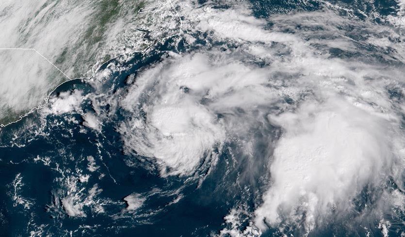
| Above: GOES-16 visible satellite image of 98L at 10:45 am EDT September 25, 2018. The coast of southeastern North Carolina is visible at upper left. Image credit: NOAA/RAMMB. |
Radar data showed that heavy rain showers from tropical disturbance 98L were moving over the Outer Banks of North Carolina on Tuesday morning. This disturbance, which preserves some of the spin from the remains of Hurricane Florence, has the potential to develop into a tropical depression by Wednesday as it moves northwards and brushes the coast of North Carolina, bringing 0.5 – 1” of rain to portions of the coast hard-hit by Hurricane Florence’s rains last week. These new rains are not likely to generate renewed flooding, though. An Air Force hurricane hunter aircraft will investigate 98L on Tuesday evening.
98L was located about 250 miles south of Cape Hatteras, NC on Tuesday morning, and was headed north at about 10 mph. Satellite loops showed that 98L was close to developing a well-defined surface circulation, but had only a modest area of heavy thunderstorms. Most of these thunderstorms were located well to the east, far from the center. There was some convection on the north side of the center, close to North Carolina, but very dry air with a mid-level relative humidity of 40% was inhibiting the growth of these thunderstorms, causing them to collapse and send out arc-shaped surface clouds away from the storm’s center, robbing it of moisture and energy.
Moderate wind shear of 10 - 15 knots and warm SSTs near 28°C (82°F) were favorable for development. These waters were considerably cooler than they were two weeks ago, thanks to the lingering cold-water wake left behind by the passage of Hurricane Florence. In its Tropical Weather Outlook issued at 8 am EDT Tuesday, the National Hurricane Center gave 98L 2-day and 5-day odds of development of 50%.
98L was expected to pass very close to Cape Hatteras late Tuesday night or early Wednesday morning, then turn more to the north-northeast and head out to sea. Due to the very dry air along the west side of 98L’s circulation, only about 0.5 – 1” inches of rain are likely along the coast. The heaviest rains will be limited to the Outer Banks, and lighter rains are expected over the region near the NC/SC border where river flooding is at its worst. Rains of this magnitude won’t do much to much aggravate river flooding, perhaps slightly slowing the fall of the rivers from peak flood stage.
The prolonged period of onshore winds that will accompany 98L will bring waves of 5 – 8 feet to the coast of North Carolina on Tuesday, with the waves subsiding to 4 – 6 feet on Wednesday. These waves will cause beach erosion and dangerous rip currents. Beach erosion from Florence was minimal across the Outer Banks, according to a roundup conducted by the Charlotte Observer, although more-significant erosion occurred where Florence made landfall near Cape Fear, reported Wilmington' Star News Online.
 |
| Figure 1. Visible-wavelength satellite image of ex-Tropical Storm Kirk at 10:35 am EDT Tuesday, September 25, 2018. Image credit: tropicaltidbits.com. |
Remains of Tropical Storm Kirk speeding towards the Lesser Antilles
The remains of Tropical Storm Kirk continued to speed to the west on Tuesday morning, at more than 20 mph. Kirk has not been able to form a closed circulation due to this fast forward motion, plus the influence of some dry air and wind shear. An Air Force hurricane hunter aircraft will investigate ex-Kirk on Wednesday afternoon, if necessary.
Satellite images Tuesday morning showed that Kirk was still showing signs of organization, with some low-level spiral bands and a moderate-sized area of heavy thunderstorms. However, there was no well-defined surface circulation, and dry air on the storm’s west side was causing the thunderstorms on that side to collapse and send out arc-shaped surface clouds away from the storm’s center, robbing it of moisture and energy. Wind shear was moderate, near 15 knots, and the sea surface temperatures (SSTs) were very warm, near 29.5°C (85°F).
Forecast for Kirk
The 12Z Tuesday run of the SHIPS model predicted that SSTs along Kirk's path would remain a warm 29°C (84°F) for the remainder of the week, and the atmosphere moderately moist. Moderate wind shear of 10 – 20 knots was expected through Wednesday morning, which may allow Kirk to re-organize into a tropical storm, particularly if the storm slows its forward speed to about 15 mph, as predicted. However, by Wednesday afternoon, wind shear was predicted to rise to the high range, 20 – 30 knots, and increase even more on Thursday. This high wind shear makes it unlikely that Kirk will be a tropical storm when it passes through the Lesser Antilles Islands on Thursday. The remnants of Kirk could still pack tropical storm-force winds of 40 mph and dump heavy rains of 2 – 4” in the islands, though. In its Tropical Weather Outlook issued at 8 am EDT Tuesday, the National Hurricane Center gave Kirk 2-day and 5-day odds of development of 60%.
Leslie becomes post-tropical
In the Central Atlantic, a cold front overtook Subtropical Storm Leslie and converted it to an extratropical storm. Leslie is expected become a hurricane-strength extratropical storm by Thursday, and to meander over the Central Atlantic for at least a week, gradually acquiring tropical characteristics. By late in the week, Leslie will likely get its name back, becoming Subtropical Storm Leslie again. In its Tropical Weather Outlook issued at 8 am EDT Tuesday, the National Hurricane Center gave ex-Leslie 2-day and 5-day odds of development of 0% and 70%, respectively. Leslie is not a threat to any land areas for at least the next seven days. By early next week, it's not out of the question that Leslie could gain a symmetric warm core and take on tropical characteristics, according to phase-space diagrams from Florida State University.
 |
| Figure 2. Enhanced infrared image of Super Typhoon Trami as of 1400Z (10 am EDT) Tuesday, September 25, 2018. Image credit: RAMMB/CSU/CIRA. |
Japan in line for a fierce hit from Trami
Typhoon-weary Japan will need to prepare for another damaging landfall late this weekend or early next week if the long-term outlook for Super Typhoon Trami pans out. Tami is now roiling the Northwest Pacific about 400 miles south of Okinawa. The typhoon maxed out early Tuesday local time with top sustained winds of 160 mph, making it a Category 5 equivalent (see discussion below). Very warm waters (around 29°C or 84°F) and low wind shear (less than 10 knots) allowed Trami to intensify very rapidly over the weekend, as it vaulted from tropical storm to Category 4 strength in just 24 hours.
Trami has now undergone a second eyewall replacement cycle, a process in which a tight, smaller eye has its eyewall collapse, to be replaced by a larger-diameter eyewall formed from a spiral band. Tropical cyclones usually weaken during this process, sometimes regaining their strength afterward if conditions are optimal. As of 8 am EDT Tuesday, Trami was a Category 4 equivalent with peak winds down to 150 mph, the minimum speed needed to be ranked as a super typhoon. In addition, a midlatitude dip in the jet stream had slowed Trami’s forward motion to just 1 mph over the previous six hours, which allowed the hurricane to churn up cooler waters from below. Satellite imagery show that the cloud tops surrounding Trami have warmed considerably, which indicates that the core thunderstorms have weakened, and it is possible that Trami is already below super typhoon status. Steering currents will restrengthen later in the week, but by that point Trami will be undergoing greater wind shear and is unlikely to regain its super-typhoon status.
After sitting in nearly the same spot for too long, #Trami is now feeling the effects of cold water upwelling beneath its circulation. The warming convection is a telltale sign. pic.twitter.com/TBBBIYXypP
— Ryan Allen (@1900hurricane) September 25, 2018
Nevertheless, Trami is expected to weaken only gradually, and it poses a serious threat to Japan, including the southernmost Ryukyu Islands as well as the nation’s larger central islands. After Trami picks up forward speed later this week, most model guidance agrees that it will accelerate into a recurvating path that will take it across or near many of the Ryukyu Islands, including Okinawa, around Sunday as a Category 3 or 4 equivalent. Models project that Trami will then sweep over and parallel to populous Honshu island around Monday, perhaps still packing Category 2 winds. This angle of approach is not ideal for a big storm surge of the type produced by Jebi, which swamped one of the nation’s biggest airports (see our post from last week), but significant surge may still be a threat. Such a track could also deliver widespread damaging winds and dump torrential rains, with localized amounts topping 10”.
 |
| Figure 3. Rich moisture surrounding Trami can be seen in this map of precipitable water (the amount of moisture in a column above any point on the ground) at 1300Z (9 am EDT) Tuesday, September 25, 2018. Precipitable water amounts of close to 3” surrounding the typhoon suggest the potential for extremely heavy rain. Image credit: RAMMB/CSU/CIRA. |
Six Category 5 storms so far in 2018
Trami is the planet’s sixth Category 5 storm of 2018, along with Marcus, Maria, Lane, Jebi, and Mangkhut (thanks go to Jasper Deng for compiling this list). Hurricane Hector in the Central Pacific just missed making Category 5 status, topping out with 155 mph winds. As discussed in our January post on the three Category 5 storms of 2017, that was the lowest total since 2012, and was well below the unusually high activity of 2014 - 2016, when eight or nine Category 5s appeared each year. Earth averaged 5.1 Category 5 storms per year between 1990 - 2017, according to ratings made by NOAA's National Hurricane Center and the U.S. Navy's Joint Typhoon Warning Center. The record number occurred in the El Niño year of 1997, which had twelve Category 5 storms--ten of them in the Northwest Pacific, where most of Earth’s Cat 5s occur. The Northwest Pacific averaged 2.9 Category 5 storms per year from 1990 - 2017, including five such storms in both 2015 and 2016. Here are the details on 2018’s Category 5 storms so far:
Western Pacific
-----------------
Trami: 18Z September 24 – 0Z September 25; peak winds 160 mph
Mangkhut: 12Z September 11 – 18Z September 14; peak winds: 180 mph
Jebi: 18Z August 30 – 0Z September 1; peak winds: 175 mph
Maria: 12Z July 8 – 18Z July 8; peak winds 160 mph
Central Pacific
----------------
Lane: 0Z August 22 – 6Z August 22; peak winds: 160 mph
Southern Hemisphere
-------------------------
Marcus: 18Z March 21 – 0Z March 22; peak winds: 160 mph
 |
| Figure 4. Global Category 5 tropical cyclones from 1990 - 2018, as rated by NOAA's National Hurricane Center and the U.S. Navy's Joint Typhoon Warning Center. The quality of the database rating Cat 5s is too poor and the time series of decent data on these storms is too short to make definitive conclusions about how climate change may be affecting these most powerful of storms. Climate change is expected to make the strongest storms stronger, and we should expect to see an increase in Category 5 storms in the coming decades. |
Bob Henson wrote the Super Typhoon Trami portion of this post.


