| Above: Invest 94L in the Central Atlantic as seen on Monday morning, July 3, 2017, by the MODIS instrument on NASA's Aqua satellite. The disturbance was poorly organized, though it had an increasing amount of heavy thunderstorm activity. Image credit: NASA. |
A tropical wave located at 11 am EDT Monday about 650 miles west-southwest of the Cabo Verde Islands has the potential to develop into a tropical depression by the time it passes near or north of the Lesser Antilles Islands this weekend. This system, designated "Invest 94L" by NHC on Sunday evening, was nearly stationary on Monday morning near 9°N 34°W.
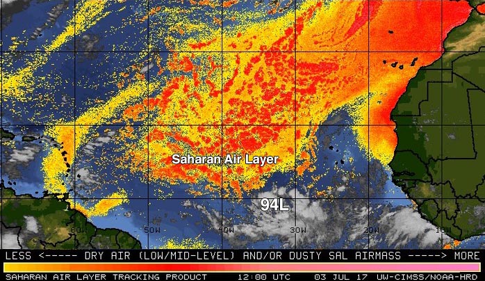
Satellite images on Monday morning showed that 94L was in the early stages of organization, with a steadily increasing amount of heavy thunderstorm activity that was poorly organized, with only a little spin. Development was likely being retarded by dry air, thanks to a presence of the Saharan Air Layer (SAL) just to the north. Wind shear was low, 5 – 10 knots, and sea surface temperatures (SSTs) were warm enough for development, near 27.5°C (82°F)--about 1°F above the seasonal norm.
 |
| Figure 1: The Saharan Air Layer (SAL) analysis from 8 am EDT Monday, July 3, 2017, showed a large area of dry Saharan air in the tropical Atlantic north of about 12°N. Invest 94L was just to the south of the SAL. Image credit: University of Wisconsin CIMSS/NOAA Hurricane Research Division. |
Forecast
The main impediment for development of 94L is the presence of the dry air to the system’s north. Otherwise, conditions are favorable for development: wind shear should mostly be moderate, and SSTs be warm enough for development--in the 27 - 28°C (81 - 83°F) range--during the week. The system does not have a high forward speed, giving it time this week to leverage Earth's spin to help itself get spinning. The Madden-Julian Oscillation (MJO), a periodic pulse of thunderstorm activity that circles equatorial regions of the globe every few weeks, is in a phase that will help development of Atlantic tropical cyclones this week. However, 94L is embedded in the larger band of heavy thunderstorms called the Intertropical Convergence Zone (ITCZ), and separation from the ITCZ may weaken 94L for a day or so by the middle of this week, as the thunderstorm clusters of the ITCZ compete with 94L for moisture.
In their 8 am EDT Monday Tropical Weather Outlook, the National Hurricane Center (NHC) gave 94L 2-day and 5-day odds of tropical cyclone development of 20% and 70%, respectively--about double the odds of 10% and 40% given on Sunday morning. The Florida State University Tropical Cyclone Genesis Portal--the top aid used by NHC to make genesis forecasts--gave 5-day odds of development of 62%, based on a consensus of the 0Z Monday forecasts from the GFS, UKMET and Canadian models.
Of our three top models for predicting tropical cyclone genesis--the European, GFS and UKMET--all but the European model showed development of 94L over the next five days. About 70% of the 50 members of the 0Z Monday European ensemble forecast and 85% of the 20 members of the 0Z Monday GFS ensemble forecast predicted development of 94L into a named storm over the next 7 days. About 30% of the GFS ensemble forecasts predicted a hurricane by next week, and 2% of the European model ensemble forecasts did so.
The models had a strong ridge of high pressure steering the system mostly west-northwest at 5 - 15 mph for the next five days, which would bring the storm a few hundred miles north of the Northern Lesser Antilles Islands this weekend. By next Sunday, a trough of low pressure expected to move off the U.S. East Coast may create a weakness in the ridge, allowing the storm to move on a more northwesterly path, potentially putting Bermuda and the U.S. East Coast at risk late next week. The more rapidly 94L develops, the more likely the storm is to exploit the weakness in the ridge and take a more northwesterly track, bringing the storm close to Bermuda next week. That is the scenario the 6Z Monday run of the GFS model painted. If 94L is slow to develop and is weak for many days, the storm is likely to keep a more southerly track, and potentially affect the northern Lesser Antilles Islands this weekend. That is the solution preferred by many of the members of the 0Z Monday European model ensemble--though the operational version of the model kept 94L a few hundred miles north of the islands.
So, it's a wait-and-see game. The next name of the list of storms is Don.


