| Above: GOES-16 visible image of 94L at 10:45 am EDT Monday, October 15, 2018. Image credit: NOAA/RAMMB. |
A broad area of low pressure (94L) over the southwestern Caribbean near Nicaragua has the potential to develop into a tropical depression by Tuesday as it moves west-northwestward at 10 – 15 mph toward Central America. The system is under moderate wind shear of 10 – 15 knots and over warm ocean waters of 29°C (84°F), conditions favorable for development. An Air Force hurricane hunter aircraft is scheduled to investigate 94L on Tuesday afternoon.
Satellite images late Monday morning showed that 94L was on its way to developing a well-formed surface circulation near the northeast coast of Honduras, and the system had a moderately large area of heavy thunderstorms to the southeast of the developing center. These thunderstorms were growing in organization and areal coverage. The one thing 94L lacks is time; its forward speed of 10 – 15 mph should bring the center inland over Belize by Tuesday afternoon. This relatively fast motion will limit the flood threat 94L poses to Central America, but 94L will be capable of bringing 2 – 4” of rain with isolated amounts of up to 8" to Belize and northern portions of Nicaragua, Honduras, and Guatemala. These rains will be capable of causing dangerous flash flooding and mudslides. In their 2 pm EDT Monday Tropical Weather Outlook, NHC gave 94L 2-day and 5-day odds of development of 40%. The next name on the Atlantic list of storms is Oscar.
 |
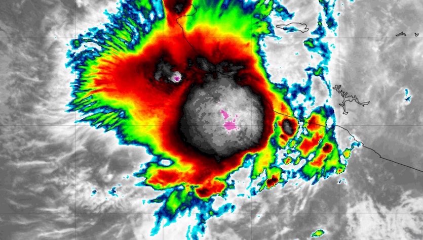
| Figure 1. Infrared satellite image of Tropical Storm Tara at 1350Z (9:50 am EDT) Monday, October 15, 2018. Image credit: tropicaltidbits.com. |
Tropical Storm Tara spins up off the Mexican coast
The Eastern Pacific got the 20th named storm of its ultra-busy 2018 hurricane season with the development of Tropical Storm Tara on Monday morning. Tara was centered about 95 miles south of Manzanillo, Mexico at 11 am EDT Monday, with top winds of 45 mph, and was bringing heavy rain to the nearby coast. This area may be dealing with Tara for several days to come, as steering currents are weak and models diverge wildly on Tara’s future. In any event, one or more days of heavy rain and localized flood risk near the coast seem probable, and NHC predicted total rainfall amounts of 3 – 5”, with isolated amounts of up to 8”. These rains will be capable of causing dangerous flash flooding and mudslides. Satellite images show that Tara is a small system, and a relatively small portion of the coast is being affected by its rains.
As of 11 am EDT Monday, the Eastern Pacific (between the International Date Line and the Americas) had racked up 293.8 units of accumulated cyclone energy (ACE), compared to the average year-to-date total (1981-2010) of 121 and the average full-season total of 132. As calculated by Phil Klotzbach (Colorado State University), the highest ACE on record for any season is 295.2 (1992), followed closely by 288.1 (2015). Models agree that 94L could help spawn yet another named storm in the Eastern Pacific by this weekend, after it crosses over Central America into the Pacific. Between this potential future system and Tara, it appears 2018 will easily vault into the #1 spot for ACE.
The 2018 hurricane season in the East Pacific (east of the Date LIne) has now had 20 named storms, 11 hurricanes, and 9 intense hurricanes. An average season has 15 named storms, 8 hurricanes, and 3 intense hurricanes, so we are well past those benchmarks with several more weeks of hurricane season remaining. The all-time records in the East Pacific are 27 named storms (set in 1992), 16 hurricanes (set in 2015, 2014, and 1992), and 11 intense hurricanes (set in 2015).
*Tropical* Tropical cyclone #Luban is nearing the eastern coast of the Arabian peninsula. Image: Suomi NPP / VIIRS pic.twitter.com/n0rS597hSu
— severe-weather.EU (@severeweatherEU) October 13, 2018
Cyclone Luban brings a year’s worth of rainfall to Oman and Yemen
Tropical Depression Luban made landfall in eastern Yemen 20 miles south of Al Ghaidah at approximately 6Z Sunday, October 14, 2018, with top winds of 35 mph. The tropical depression brought torrential rains to eastern Yemen and western Oman as the storm moved inland, with 24-hour rainfall amounts of 5.71” and 5.43” at Dalkout and Salalah in Oman, respectively, according to muscatdaily.com. This part of the Arabian Peninsula averages only about five inches of rain per year, so the resulting flash flooding was intense. Neighboring Yemen undoubtedly received even heavier rains than Oman, but we have no weather reporting stations from the war-torn nation to tell us how much rain fell. Judging by photos posted on Twitter (below), eastern Yemen was hard-hit by extreme flooding (thanks go to WU commenter BarabaraGermany for the tip).
Update (October 17): The camel you see struggling through floodwaters in the first tweet below was later rescued.
لقطات من فضيانات محافظة #المهرة شرق #اليمن
— تركي المحيا (@TurkiAlmohaiya) October 15, 2018
يوم أمس الأحد 14 أكتوبر 2018م
عاصفة #لبان #Luban pic.twitter.com/sHRk4Rwjzr
صور مؤلمة في محافظة #المهرة شرق #اليمن بعد اجتياح العاصفة #لبان #Luban للمنطقة
— تركي المحيا (@TurkiAlmohaiya) October 15, 2018
يوم أمس الأحد 14 أكتوبر 2018م pic.twitter.com/ZIzZoydXJr
We'll have an update on Hurricane Michael's wind damage later today.
Bob Henson contributed the Tara section of today's post.


