| Above: Invest 92L and 93L off the coast of Africa, as seen at 8:50 am EDT Friday, September 7, 2018. The edge of Florence is visible at upper left. Image credit: Levi Cowan, tropicaltidbits.com. |
Two tropical waves off the coast of Africa—92L and 93L (now Potential Tropical Cyclone Eight)—are likely to develop into tropical depressions by this weekend, and will likely become Tropical Storm Helene and Tropical Storm Isaac by early next week, though it's not yet clear which wave would get which name. With a resurgent Hurricane Florence expected to be intensifying as it approaches the U.S. East Coast early next week, we may well have three simultaneous Atlantic hurricanes during this coming peak week of the Atlantic hurricane season.
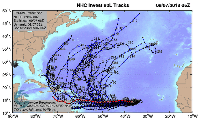
The most concerning of the newly developing storms is a strong tropical wave (92L) located about 650 miles west of the Cabo Verde Islands at 8 am EDT Friday, which was headed west at about 5 - 10 mph. This system is close to tropical depression status, and has the potential to affect the Caribbean as a hurricane next week. Conditions for development were adequate but not great on Friday morning, with sea surface temperatures (SSTs) near 27.5°C (81.5°F), an atmosphere with a mid-level relative humidity of 55 – 60%, and moderate wind shear of 10 - 15 knots. The dry air of the Saharan Air Layer lay to the northwest, and this dry air was interfering with development. Satellite images on Friday morning showed that the wave had become significantly more organized since Thursday, with a broad surface circulation, a moderate amount of heavy thunderstorms, and several low-level spiral bands.
 |
| Figure 1. Predicted tracks for 92L from the 20 members of the 0Z Friday run of the GFS ensemble forecast (grey lines) along with the operational run of the European model (red line). About 32% of the lower-resolution GFS ensemble members predicted that 92L would pass through the Lesser Antilles Islands next week, as did the European model’s forecast. Image credit: CFAN. |
92L likely to become a hurricane by Tuesday
The 12Z Friday run of the SHIPS model predicted that SSTs would remain nearly constant, the atmosphere would stay moderately dry, and wind shear would be light to moderate for the next five days for 92L, allowing for steady development. The 0Z Friday runs of our top three models for predicting tropical cyclone development—the European, GFS and UKMET models—all predicted development into a tropical depression by this weekend. Our top intensity models—the HWRF, DSHIPS, and LGEM—predicted that 92L would be a hurricane by Tuesday, and this is a reasonable forecast. In their 8 am EDT Friday Tropical Weather Outlook, NHC gave the system 2-day and 5-day odds of development of 90%. The next name on the list of Atlantic storms is Helene.
Steering currents favor a slow west to west-northwesterly track at 5 - 10 mph over the next three days, then a speed-up to 15 mph early next week. This motion would bring 92L into the Lesser Antilles Islands as early as Thursday, September 13, as predicted by the 0Z and 6Z Friday operational runs of the GFS model and the 0Z Friday operational run of the European model. About 32% of the 20 ensemble members of the 0Z Friday GFS model and 62% of the the 50 ensemble members of the 0Z Friday run of the European model also showed 92L entering the Caribbean next week.
Complicating the long-range forecast is the non-tropical low pressure system expected to form a few hundred miles west of the Azores by Tuesday. This low may or may not get invigorated by Gordon's remnants, which will be dumping heavy rain across the Midwest this weekend, then rotating over Newfoundland and back southeast over the North Atlantic later next week. The degree of any Gordon-related invigoration could have a major impact on the steering pattern for both 92L and 93L. If this non-tropical low pressure system grows large and dips far to the south, it will be capable of turning 92L to the northwest before it reaches the Lesser Antilles Islands, sparing the Caribbean. In summary, we are still several days from being confident of whether or not 92L is likely to be a significant threat to the Caribbean, but it is likely to be a hurricane headed that way by Tuesday.
93L (PTC 8) a heavy rain threat for the Cabo Verde Islands
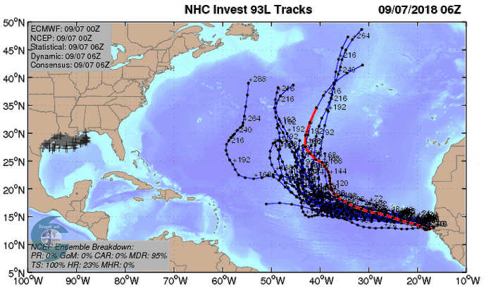
A strong tropical wave (93L) moved off the coast of Africa on Thursday evening, and was located a few hundred miles southeast of the Cabo Verde Islands at 8 am EDT Friday. At 11 am EDT Friday, NHC labeled this system Potential Tropical Cyclone Eight (PTC 8) and issued a Tropical Storm Warning for the Cabo Verde Islands. This wave was headed west to west-northwest at about 10 mph, and will likely bring tropical storm conditions to the southern Cabo Verde Islands on Saturday and Sunday. Favoring development of the wave were warm sea surface temperatures (SSTs) near 28°C (82°F) and a moist atmosphere. Slowing development was moderate wind shear of 15 - 20 knots. Satellite images on Friday morning showed that the wave was steadily growing more organized, with an impressive area of heavy thunderstorms.
 |
Figure 2. Predicted tracks for 93L from the 20 members of the 0Z Friday run of the GFS ensemble forecast (grey lines) along with the operational run of the European model (red line). None of the forecasts predicted that 93L would threaten any land areas after passing the Cabo Verde Islands on Sunday. Image credit: CFAN. |
93L likely to become a tropical storm by Saturday
PTC 8 is expected to move west-northwest at about 10 mph this weekend, passing very near the southern Cabo Verde Islands on Sunday. The 0Z Friday runs of our top three models for predicting tropical cyclone development—the European, GFS and UKMET models—all predicted development within two days. In their 8 am EDT Friday Tropical Weather Outlook, NHC gave the system 2-day and 5-day odds of development of 90%. Once it does form, intensification to a hurricane appears possible. Our top intensity models—the HWRF, DSHIPS, and LGEM—had one, the HWRF, predict that 93L would be a hurricane by Monday. The next name on the list of Atlantic storms after Helene is Isaac. The models have been consistently showing that this system is likely to turn more to the west-northwest and then northwest after affecting the Cabo Verde Islands, taking the storm into the Central Atlantic, far from any land areas.
We’ll have a post later today on Hurricane Florence, which is becoming of increasing concern to the U.S. East Coast.


