| Above: Infrared GOES-16 satellite image of the tropical wave known as Invest 90L, located over the central Caribbean at 1530Z (11:30 am EDT) Saturday, August 5, 2017. Image credit: NASA/MSFC Earth Science Branch. |
Heavy rains will be heading toward Nicaragua and Honduras from a strong tropical wave in the central Caribbean. Dubbed Invest 90L, the system could become a Gulf of Mexico tropical storm early next week if it doesn’t run aground over Central America. Meanwhile, the wave known as Invest 99L continues slogging through the tropical Atlantic, still disorganized but maintaining the potential to become a named storm next week as it nears the Lesser Antilles. The next two names on the Atlantic list are Franklin and Gert.
Showers and thunderstorms (convection) blossomed around Invest 90L on Friday night, and satellite imagery showed an increasing amount of spin near the center of the convection, located midway between Jamaica and Colombia. The wave may continue to slowly organize on Saturday as it moves west to west-northwest at about 10 mph. Conditions will be very favorable for 90L to develop further on Sunday into Monday in the northwest Caribbean. The 12Z Saturday run of the SHIPS statistical model predicts that 90L will encounter sea surface temperatures (SSTs) near 30°C (86°F), deep oceanic heat content, light wind shear (below 10 knots), and a very moist environment (mid-level relative humidity around 80%).
Our top three global models for hurricane prediction have largely stuck to their guns regarding 90L, with the European model the only one consistently calling for 90L to develop in its operational runs. There is ample reason to be cautious when only one of the three leading models foresees development, but given the organization now under way and the prime conditions lying ahead of 90L, at least some strengthening seems plausible. In its tropical weather outlook issued at 8 am EDT Saturday, the NOAA/NWS National Hurricane Center gave 90L a 30% chance of development into at least a tropical depression by Monday and a 50% chance by Thursday.
One of the biggest short-term questions is whether 90L will track mainly due west, which could take the wave along the Honduras coast or just inland from it on Sunday. In this case, 90L may never progress beyond tropical-wave status. However, if 90L maintains a distinct low-level center that stays well north of the coast, it could become a tropical depression or tropical storm by the time it reaches Belize and the Yucatan Peninsula of Mexico around Monday. About a third of the European model ensemble members from 0Z Saturday favor this northern trajectory and tropical-storm status. The northern scenario also leaves the door open for further development in the Bay of Campeche, a very favorable location for tropical cyclones because of its warm SSTs and concave topography. Again, roughly a third of the Euro ensemble members from Friday night call for a tropical storm in the Bay of Campeche or just to its north, approaching northeast Mexico or far southern Texas around the middle of next week. In contrast, only about a quarter of GFS ensemble members call for development, with lower tropical-storm intensities and a track into the far southern Bay of Campeche.
 |
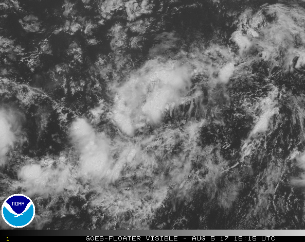
| Figure 1. Visible satellite image of Invest 99L at 1515Z (11:15 am EDT) Saturday, August 5, 2017. Image credit: NOAA/NESDIS. |
99L approaches the Central Atlantic
Located several hundred miles southwest of the Cape Verde Islands, Invest 99L is having some trouble getting its act together. The wave remains quite elongated, and convection remained scattered and relatively weak on Friday night, failing to take advantage of the typical nocturnal bump-up in tropical thunderstorm development. In its 8 am EDT Saturday outlook, NHC identified a surface low near 10°N, 33°W, with other areas of convection to its west and east. We’ll have to see if this low remains the predominant center as the wave continues moving west at 10 mph.
While the European model has been dubious about 99L for days, the GFS and UKMET models continue to favor development. However, the Friday night UKMET run depicts only a weak system, and the GFS ensemble and operational runs have pulled back notably on the potential they had flagged earlier for a strong hurricane to approach the U.S. East Coast roughly a week from now. More than 80% of GFS ensemble members from Friday night called for 99L to become a tropical storm by Monday, when the wave is expected to be approaching the northern Lesser Antilles. The big difference this time is a more southerly track than previous runs, which would take 99L closer to the northeast Caribbean. Such a track would produce much more interference from land interaction with the Greater Antilles, and increasing wind shear from an upper-level trough could also be affecting 99L by early next week. A quarter of the GFS ensemble members from Friday night insisted that 99L could survive these factors to potentially affect the U.S. Gulf or Atlantic coast as a tropical storm or a hurricane more than a week from now. Meanwhile, less than 20% of the European ensemble members called for 99L to develop into a tropical depression or weak tropical storm over the next couple of days on approach to the Lesser Antilles. All of them snuffed out 99L as it enters the eastern Caribbean, a notoriously difficult location for tropical development.
In its Saturday morning outlook, the NOAA/NWS National Hurricane Center gave 90L a 40% chance of development into at least a tropical depression by Monday and a 70% chance by Thursday.
We'll be back with our next update on the tropics by Sunday afternoon.


