| Above: GOES-East visible satellite image of 90L taken at 10:30 am EDT May 24, 2018. Lightning activity is overlaid in color. Image credit: NOAA/RAMMB . |
A broad area of low pressure (90L) centered on the coast of the Yucatan Peninsula between Belize and Cozumel, Mexico has grown moderately more organized since Wednesday. This system was spreading showers and thunderstorms over Cuba, Mexico’s Yucatan Peninsula, and the Florida Straits on Thursday morning. 90L had a modest-sized area of heavy thunderstorms that were slowly becoming more organized, as seen on satellite loops. Wind shear over the system was a high 25 - 30 knots on Thursday, which is unfavorable for development. An Air Force hurricane hunter aircraft is scheduled to investigate 90L on Friday afternoon.
 |
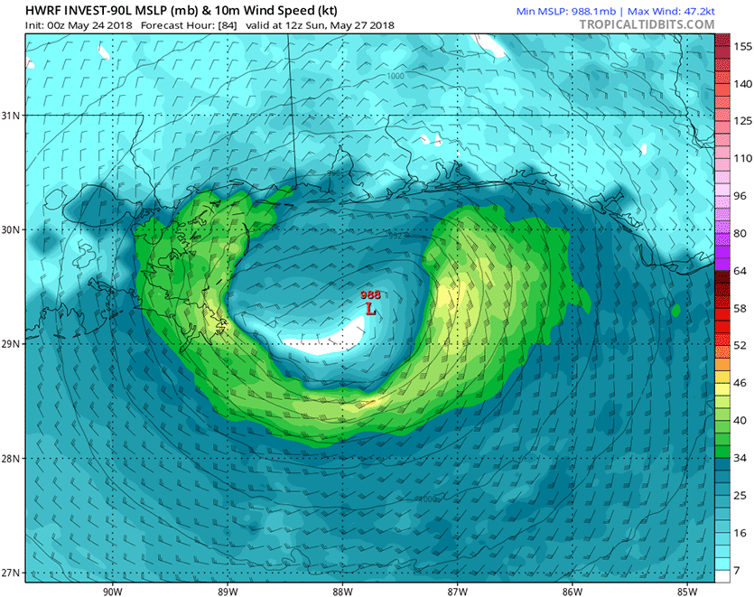
| Figure 1. Predicted wind speed (knots) for 90L at 12Z Sunday, May 27, 2018 (8 am EDT) as predicted by the 0Z Thursday, May 24, 2018 run of the HWRF model. The forecast shows 90L’s strongest winds in an arc well removed from the center of circulation (988 mb central pressure), which is characteristic of a subtropical storm. Peak winds in this run were 55 mph, with winds in excess of tropical-storm strength (34 knots, green colors) occurring along a swath from southeast Louisiana to the Florida Panhandle. Image credit: Levi Cowan, tropicaltidbits.com. |
The forecast for 90L
Wind shear is predicted to stay high through at least Friday, making development into a depression unlikely until this weekend. For Saturday and Sunday, the 12Z Thursday run of the SHIPS model was predicting moderate wind shear of 10 – 20 knots, which is more favorable for development. 90L is expected to move slowly northward at about 5 mph through the central and eastern Gulf of Mexico over the next few days, where sea surface temperatures (SSTs) range from 25 - 28°C (77 - 82°F)—near the lower limit of 26.5°C (80°F) that is typically needed for a tropical depression to form. Since the system will be moving over these marginally warm waters for several days, it has the potential to gradually acquire tropical characteristics and become a warm-cored tropical or subtropical depression by Sunday. A more easterly track will take 90L closer to Florida, where waters are cooler, which would increase the chances that a subtropical depression would form rather than a tropical depression. In a special 8 am EDT Thursday Tropical Weather Outlook, the National Hurricane Center gave the system 2-day and 5-day odds of development of 40% and 80%, respectively. The first name on the Atlantic list of storms for 2018 is Alberto.
According to Dr. Phil Klotzbach, since 1950, 8 Atlantic named storms have formed in the last week of May (May 25 - 31). And, according to TWC’s Greg Diamond, it's not uncommon for Atlantic tropical systems to form in May, but it is uncommon to see one develop in the Gulf of Mexico as is currently forecast. The only other one was Arlene, in 1959.
 |
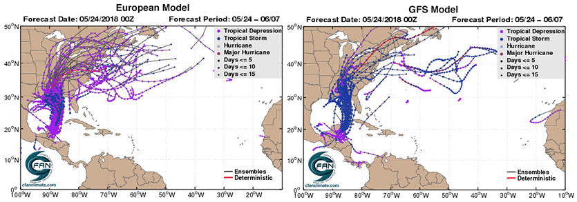
| Figure 2. Predicted tracks of a potential tropical depression or tropical storm from the 0Z Thursday European model ensemble forecast (left) and 0Z Thursday GFS ensemble forecast (right). About 50% of the ensemble members of the European model, and 80% of the members of the GFS model, predicted that a depression would form by early next week. The purple dots show where the predicted storm is at tropical depression strength, and the blue dots, tropical storm strength. None of the ensemble members predicted that a hurricane-strength storm (light blue dots) would form. Image credit: cfanclimate.com. |
Model predictions coming together
The 0Z and 06Z Thursday operational runs of our top three models for predicting tropical cyclone genesis--the European, GFS and UKMET models--all showed development of 90L into a depression, and were more unified in their forecasts compared to their Wednesday forecasts. In particular, the 06Z Thursday run of the GFS model made a big shift to the west, putting it in much closer agreement with the European model. The 0Z Thursday run of the European model predicted that a tropical depression would form by Saturday in the central Gulf of Mexico, then make landfall on Monday night over Louisiana. The 6Z Thursday operational run of the GFS model showed development near the western tip of Cuba on Saturday morning, with the system making landfall early Monday morning in the Florida Panhandle. The 0Z Thursday run of the UKMET model predicted development in the Northwest Caribbean on Saturday, with the system making landfall in the Florida Panhandle on Monday night.
About 50% of the 50 ensemble members of the 0Z Thursday European model forecast and 80% of the 20 members of the 0Z Thursday GFS forecast predicted that a tropical or subtropical depression would form over the eastern Gulf of Mexico by early next week. These solutions predominantly predicted a track that would result in landfall between Louisiana and the Florida Panhandle between Sunday and Tuesday. None of these ensemble forecasts predicted that a hurricane-strength storm would occur.
 |
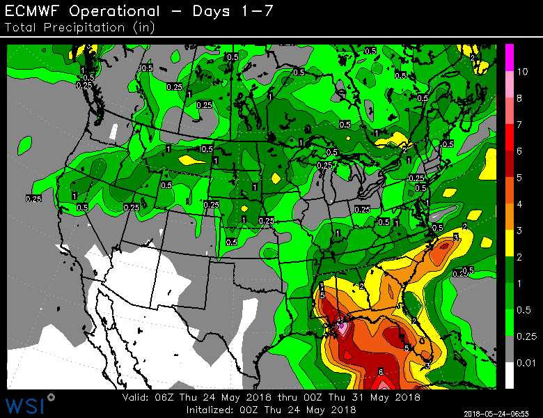
| Figure 3. Predicted precipitation for the 7-day period ending at 8 am EDT Thursday, May 31, 2018. Invest 90L is predicted to bring rainfall amounts of 3 - 5 inches to much of the Southeast U.S. Image credit: National Weather Service. |
 |
| Figure 4. The 0Z Thursday run of the European model predicted that 90L would contribute to 7-day precipitation amounts of 8” near its landfall location on the coasts of Alabama and Mississippi, with a large area of 3 – 5” falling across the Southeast U.S. |
Heavy rains the main threat
Even if 90L does not develop, the counter-clockwise flow of air around this low-pressure system in combination with a very wet tropical airmass will funnel large amounts of tropical moisture over Cuba and the Southeast U.S., resulting in very heavy rains during the coming week. Adding to the rainfall potential will be the possibility that 90L will bump into a strong ridge of high pressure to its north early next week, which would block the storm’s progress and result in a slow movement. The latest precipitation guidance from the National Weather Service and the European model (Figures 3 and 4) show that 3 – 5” of rain are expected over the next 7 days over much of the Southeast U.S. Today’s update to the weekly Drought Monitor shows that the Southeast U.S. is now mostly drought-free, though there are still large swaths of abnormally dry conditions. This will make the region less prone to flooding than usual for this time of year.
It is unlikely that 90L will intensify into a hurricane, so I doubt wind damage is a big concern with this storm. I think the most likely outcome is that 90L will be a 40 - 50 mph Subtropical Storm or Tropical Storm Alberto at landfall on Monday. If this occurs, the large wind field of the storm would be able to generate a storm surge in excess of three feet in Florida's Apalachee Bay--if the storm makes landfall in the Florida Panhandle.


