Widespread heavy snow and a damaging ice storm are on the table from the South into the Midwest and Northeast, including a potential nor'easter. Here’s the very latest forecast.
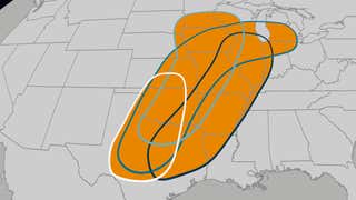
Winter Storm Fern will bring significant icing and heavy snow to the Deep South starting Friday night and continuing all weekend long. All precipitation types will be possible, as rain will change over to freezing rain, sleet and then eventually snow from north to south. Minor ice accumulations will be possible in Houston, Austin and San Antonio with higher and more damaging ice accretion likely in Dallas, Fort Worth, Shreveport, Greenville and Tupelo. This will be a long-duration event, so tree damage and power outages are likely and travel will become difficult to impossible this weekend, so adjust travel plans and have a winter emergency kit in your car just in case. Click here for your latest snow and ice forecasts.
Empty store shelves, salt trucks on the move and crews preparing roadways are all signaling an incoming winter storm set to affect 230 million Americans. From Texas through the Carolinas and across much of the East, snow, ice and dangerous cold could disrupt travel and daily life through the weekend, making now the time to prepare.
Winter Storm Fern will bring heavy snow and a wintry mix to millions across the Northeast, mid-Atlantic and Ohio Valley Saturday night into Sunday. The rain/ice line continues to shift so now the I-95 corridor has potential to see heavy snow, followed by sleet or freezing rain. Either way, this is going to be a major snow storm with the potential for at least a foot of snow along the I-95 corridor. Travel will become difficult to impossible, so adjust plans now and be sure to have a winter emergency kit in your car just in case. Watch this video to see how the forecast has changed.