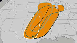
A blast of arctic air from Canada also brought a fresh round of heavy snow to the Chicago area over the weekend. Many places were blanketed by more than 5 inches of snow, and while snow plow convoys hustled to keep the roads clear, a semitrailer jackknifed off a highway in Sterling. Fliers also got stuck for hours at Chicago’s O’Hare International Airport. Watch this video for the latest.
Another quick-hitting system will bring more snow to the mid-Atlantic, falling in the same areas that saw snow on Friday. Snow will impact travel along the I-95 corridor Monday afternoon into the evening. The highest snow totals will likely be across western Virginia and West Virginia. Click on this video to see an hour-by-hour forecast.
A clipper system will slide across the Great Lakes to the Northeast midweek, bringing another shot of snow for the region. Widespread snow totals of 3-5 inches are expected with some locations possibly seeing up to a foot. And that’s not all — the system will also usher in another blast of cold, arctic air. Check out the timing here.
Another atmospheric river is set to slam into the Pacific Northwest. While some of these can be beneficial, this one may be largely hazardous for flooding rain. Here's the latest forecast.