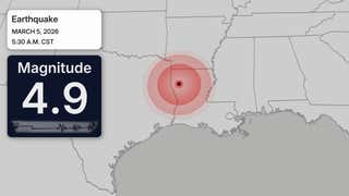
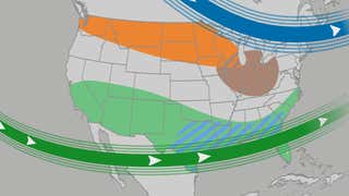
This historic storm is already hitting the South, and will spread destructive ice and heavy snow over 34 states through Monday including the Midwest and Northeast. Here is the very latest forecast.
Today is the last day to prepare across the Northeast as the snow will begin to move in from the southwest tonight. The heaviest snow will fall on Sunday, with snow changing over to a freezing rain and sleet mix along the I-95 corridor from Washington and Baltimore up to Philadelphia and even New York City. However, 8-12 inches is still expected at these major hubs despite the chance for ice. A wide swath of 12-18 inches of snow will be possible for areas that see all snow and no mix, and this includes Boston. Get your hour-by-hour forecast and the latest snow and ice totals here.
A winter storm, named Fern by The Weather Channel, is posing a significant ice accumulation threat across much of the South and Southeast. Over a quarter inch of ice is possible for major cities like Dallas, Nashville and Atlanta, which can mean widespread power outages, tree damage and hazardous travel.