| Above: Pedro Reimundo installs wood shutters on a home in Florida City, Fla., Friday, Sept. 8, 2017. Image credit: AP Photo/Gaston De Cardenas. |
Hurricane Irma was barreling toward South Florida late Friday as a top-end Category 4 storm, with sustained winds of 155 mph. Although Irma will undergo minor ups and downs in strength through Saturday, Irma’s trek over the extremely warm waters of the Florida Strait on Saturday night may give it a final upward bump in intensity. The National Hurricane Center predicted in its 5 PM EDT Friday update that Irma will approach the Florida Keys as a Category 5 storm early Sunday before making landfall Sunday afternoon along the far southwest coast of Florida. Irma represents an extreme danger to much of Southern Florida, as well as portions of northern Cuba and the southernmost Bahama Islands. If you live by the coast in an area that has been ordered to evacuate due to storm surge, get out now if you can safely do so.
 |
| Figure 1. The 5 pm Friday, September 8, 2017 wind probability forecast fro hurricane-force winds from NHC. |
The Florida Keys and Southwest Florida will take the full force of the storm, with Category 4 winds driving a life-threatening storm surge of 8 - 12 feet. Although Irma is expected to track closer to the west coast of Florida than the east coast, Category 1 winds will potentially affect the east coast of Florida from Miami to West Palm Beach, and winds at or near hurricane force may extend northward across the central peninsula to the Orlando area (Figure 1). Dangerous storm surges will affect the entire east coast of Florida, as well as Georgia and South Carolina. NHC had not yet issued a storm surge watch for the coasts of northern Florida, Georgia, and South Carolina as of 5 pm EDT Friday, but I expect the surge will be at least 3 - 5 feet in much of this region, which is lower than the 4 - 8 foot levels observed last October during Hurricane Matthew.
 |
| Figure 2. Synthetic Aperture Radar (SAR) image of Irma taken at 6:53 am EDT September 8, 2017, when the hurricane was undergoing an eyewall replacement cycle. The inner eyewall had a diameter of 24 miles (38 km), the outer eyewall had a diameter of 57 miles (92 km), and the eye was 11 miles (18.5 km) across. The inner eyewall collapsed later that morning, and the hurricane stabilized with an eye diameter of 46 miles later that morning. Winds are shown in meters per second; multiply by 2.24 to get miles per hour. Image credit: Hans Gruber, University of Miami/CSTAR. |
Irma’s status on Friday afternoon and evening
Irma moved west to west-northwest at about 14 mph on Friday afternoon, slowly drawing closer to the coast of Cuba. Irma completed an eyewall replacement cycle late Friday morning, where the inner eyewall (diameter 24 miles) collapsed, and was replaced by a new outer eyewall with a diameter of 45 – 57 miles. Infrared satellite images on Friday afternoon and evening showed that the areal extent and intensity of Irma’s core area of heavy thunderstorms were staying relatively constant, and Irma remained a high-end Category 4 hurricane. A NOAA hurricane hunter plane in the storm Friday afternoon found top surface winds near 125 mph on their first pass through the eye near 5:13 pm EDT, with a surface pressure of 925 mb. Their 2nd pass at 6:35 pm found a slightly lower pressure of 924 mb, and an eyewall that had contracted to 35 miles in diameter, indicating that Irma may be strengthening.
Intensity forecast for Irma
It is uncommon for a major hurricane that suffers a large decrease to its strength and organization to make a full recovery back to its former strength. I’m not expecting Irma to return to its 185 mph Category 5 status, and I think even a low-end Cat 5 with 160 mph winds is unlikely—though the 5 pm Friday NHC forecast called for that to happen. Much of Irma’s circulation is now over Cuba, and I expect that the core of the hurricane will pass over the Cuban coast for several hours on Saturday, as predicted by the 12Z Friday run of the European model. Conditions are otherwise favorable for intensification through Sunday, with a moist atmosphere, light wind shear less than 10 knots, and very warm ocean waters near 30°C (86°F). Irma is likely to be a large and very dangerous Category 3 or 4 hurricane with 120 – 150 mph winds when it makes landfall in the Florida Keys on Sunday morning.
 |
| Figure 3. WU model map image showing the track for Irma from the 12Z Friday, September 8, 2017 suite of computer models. All of them showed a track through the Florida Keys and into Southwest Florida. |
Track forecast for Irma
Slight shifts westward and southward occurred in the models today, resulting in most of them bringing Irma very near or over the north coast of Cuba for 6 - 12 hours on Saturday morning. This is bad news for Cuba, but good news for Florida, since it means the hurricane will not be able to intensify as much as it could have. There is a chance (perhaps 20%) that Cuba could disrupt Irma enough to reduce it to a Category 2 storm by the time of landfall in South Florida on Sunday morning. However, the northern portion of Cuba is relatively flat, and NHC does not expect Irma’s encounter with Cuba to weaken the hurricane. As of 5 pm EDT Friday, the latest available runs (12Z) of all of our top models for tracking hurricanes—the European, GFS, HWRF, HMON, and UKMET—had Irma re-intensifying after leaving Cuba, making landfall in the Middle or Lower Florida Keys on Sunday morning between 2 am and 8 am, then turning north or north-northwest and making a second landfall near Marco Island or Naples between 11 am and 2 pm. High tide at Naples is at 3 am and 4 pm on Sunday, and low tide is at 9:30 am and 9:30 pm. The difference between low tide and high tide is about 2.5 feet, so Irma will drive a significantly lower storm tide to the coast if it hits at low tide.
The 18Z Friday run of the HWRF and HMON models shifted west, and had Irma hitting Fort Myers, which makes me very uncomfortable. Since the average error in a 2-day forecast is about 90 miles, it is important to remember that the models may still have additional shifts, and one must pay attention to the NHC cone of uncertainty. If you are in the cone of uncertainty, you are in danger of a direct hit. Tampa is still in the cone, and could potentially receive a direct hit by Irma, though probably not until the hurricane had traveled over land for a considerable distance, reducing its strength to a Category 1 storm.
 |
| Figure 4. Peak storm surge heights in SW Florida as simulated by NOAA’s SLOSH model for Hurricane Donna of 1960. An animation of the surge from Donna is on WU’s storm surge animation page. |
Southwest Florida storm surge history
Southwest Florida has seen a number of large storm surges from hurricanes that rival the predicted 8 – 12’ storm surge from Hurricane Irma. Category 3 Hurricane Wilma (2005) brought a peak surge of 13.0’; Hurricane Katrina (2005), 4.0’; and Hurricane Donna (1960) brought a surge of over 11’ to SW Florida, and 13.5’ to Upper Matecumbe Key in the Florida Keys.
The best historical analogue for a hurricane that follows NHC’s 5 pm EDT Friday track and intensity forecast for Irma may be Hurricane Donna of 1960, which tore through the Florida Keys just northeast of Marathon as a Category 4 storm with 140 mph winds. The hurricane continued to the northwest along the southwest coast of Florida, passing over Naples and Fort Myers before turning inland to the northeast. Donna maintained Category 2 strength into central Florida, then weakened to a Category 1 storm as it passed near Orlando, exiting the coast near Daytona Beach. Donna killed 148 and caused $387 million in damage (1960 dollars). According to storm surge expert Dr. Hal Needham, Hurricane Donna also brought a storm tide of 4 - 8 feet in Biscayne Bay, just south of Miami, and we can expect that Irma might bring similar water levels.
If Donna were to hit today, damage would likely be more than $50 billion, according to three separate estimates. ICAT estimates a loss of $66 billion; according to a 2006 AIR Worldwide publication, “What would they cost today? The estimated impact of historical catastrophes on today’s exposures”, a repeat of Donna in 2005 would have caused $26 billion in insured losses. Since uninsured losses from a hurricane are typically roughly equal to insured losses, this would put the cost of a repeat Donna at $52 billion in 2005. That was 12 years ago, and according to a 2006 report by AIR Worldwide, catastrophe losses should be “expected to double roughly every 10 years because of increases in construction costs, increases in the number of structures and changes in their characteristics.” Thus, a repeat of Donna in 2017 could be expected to generate roughly $100 billion in losses. An independent analysis done in 2012 by Karen Clark & Company, “Historical Hurricanes that Would Cause $10 Billion or More of Insured Losses Today”, found that a repeat Donna in 2012 would have done somewhat less damage (but still a staggering amount): $25 billion in insured losses, or roughly $50 billion in total losses.
According to a 2015 article in naplesnews.com, 179,681 homes in the Naples metro area, with a reconstructive value of more than $42 billion, were located within storm surge risk zones. More than 76,000 homes in Naples with a value of $17.5 billion are in “extreme” risk zones, meaning they would be affected by all hurricane category levels. With this sort of exposure in Naples alone, we can expect damage from Irma in Florida alone to be in the tens of billions if the hurricane hits SW Florida as a Category 4 storm as predicted.
Key points
If you are in a mandated evacuation zone, evacuate. These zones are created for a reason, and Irma is not a storm to be toyed with.
Irma will be tracking north-northwest along the length of the Florida peninsula. The most recent consensus of models is that this track will run inland along the west side of the Florida peninsula from south to north, although it could end up just offshore or farther inland. There are no recent precedents for Irma’s expected north-northwest track. The best analog would be Hurricane Cleo (1964), which took a similar NNW track along the eastern peninsula. Cleo was a much weaker storm than Irma, though: it weakened from a Cat 2 at landfall near Miami to a tropical storm near Savannah, GA. Hurricane Donna (1960) traveled over land from the SW to NE sides of the peninsula: Donna was a Cat 4 near Marathon and still a Cat 1 when it moved back offshore at Daytona Beach.
The highest risk for the worst winds is in South Florida. The very strongest winds will be in the eyewall, especially just east of Irma’s center as it moves north. If Irma comes inland across far southwest Florida, it may pass directly over Naples, and the eyewall will extend across the Everglades and perhaps as far as portions of Miami. Winds will be stronger at the upper stories of high-rise buildings, up to a full category above surface-level speeds. We can expect many windows in the Miami area that are not up to current code to be blown out. Only a slight eastward departure in track could bring the core of the most dangerous winds to the Miami area.
In you live outside the evacuation zone in far South Florida, take shelter in as sturdy a building as possible. Mobile homes are not safe shelter in the winds of a major hurricane.
Dangerous storm surge is expected across far South Florida, including the Naples and Miami areas, the Florida Keys, and the Everglades. There is the potential for water heights of 9 or more feet above ground level in some coastal areas from Cape Coral/Fort Myers to the Everglades, as well as along parts of Biscayne Bay. The surge may be highly variable and quickly changing along and near Biscayne Bay in the Miami area. In southwest Florida, the surge may be greatest during the southwesterly onshore winds after Irma has passed just to the north.
Dangerous storm surge—possibly higher than the surge during Matthew—can be expected from northern Florida to southern South Carolina, especially along the Georgia coast (see Figure 5). The concave coastline in this area tends to concentrate storm surge. Significant surge can be expected even if Irma weakens before reaching Georgia, as there will be huge amounts of momentum in the water already set into motion by that point.
Power outages will affect millions of Floridians and could last for days or weeks.
Tropical storm force winds (sustained winds of 39 mph or more) may extend well inland across parts of southern Georgia. These could be strong enough to topple trees and knock out power.
 |
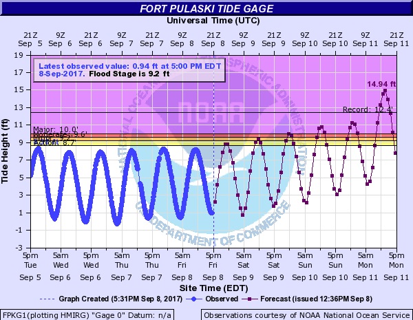
| Figure 5. As of Friday afternoon, September 8, the Savannah River at Fort Pulaski, Georgia, was predicted to rise several feet above its all-time high crest of 12.45 feet recorded during Hurricane Matthew on October 8, 2016. This estimate could go up or down as the storm evolves; please consult local officials for more detailed/updated information on predicted surge levels along the Southeast U.S. Coast. Image credit: NOAA/AHPS. |
 |
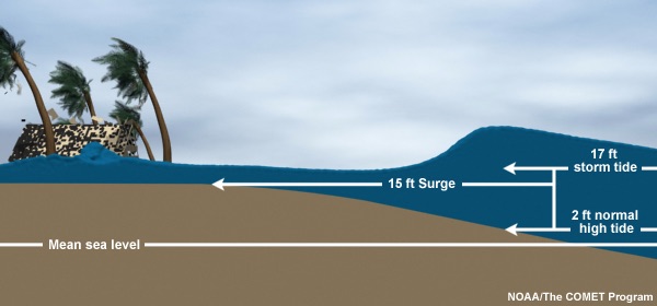
| Figure 6. Storm surge from a hurricane is combined with routine astronomical tides to produce what is known as the storm tide. Image credit: NOAA and UCAR/COMET Program. |
Understanding the language of storm surge
The words that are used to define the high water associated with hurricanes along and near coastlines can be confusing. Here are the key terms:
- Storm surge: The water pushed inland by the circulation of the hurricane.
- Storm tide: The combination of storm surge and the local tide at any given point in time.
- Inundation: The height of water above ground level at any point.
The effects of a given storm surge are accentuated if the surge arrives at high tide, and they are blunted if the surge hits at low tide. Together, these two factors produce what’s known as the storm tide. The inundation (the amount of water above ground level at any given spot) will depend on the height of the storm tide as well as local elevation above sea level. Runoff from torrential inland rains can add to these totals, although this is usually a relatively small factor.
Storm Surge Warnings, which are now issued as a routine part of NHC guidance, indicate where life-threatening inundation from rising water moving inland is possible within the next 36 hours. NHC also issues inundation maps, which account for storm surge, tides, and local elevation but not waves or rainfall-related flooding. The inundation maps show the water height that has about a 10% chance of being exceeded at any given spot.
Rainfall outlook for Irma
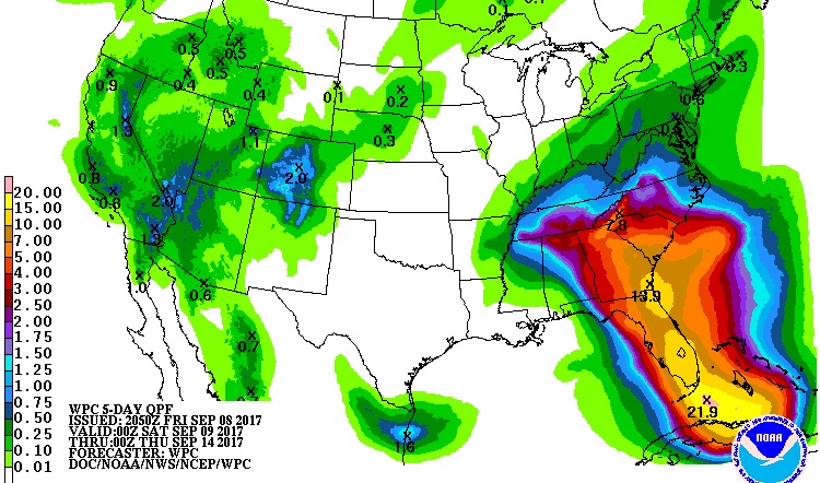
Because Irma will be moving steadily northward once it makes its turn, rainfall amounts will be far less than the top totals of 40” – 50” recorded in slow-moving Hurricane Harvey. Still, Irma is a large hurricane that will dump torrential rain along and near its path. Totals of 5” – 15” are expected throughout the Florida peninsula into eastern Georgia and southern South Carolina, with pockets of even higher amounts near far South Florida and close to the Georgia coast (see Figure 7).
 |
| Figure 7. Rainfall predicted for the 5-day period from 8:00 pm EDT Friday, September 8, to 8 pm Wednesday, September 13, 2017. Image credit: NOAA/NWS/WPC. |
How to find out about Florida evacuations
A list of current evacuation orders can be found at FloridaDisaster.org’s Hurricane Irma page (Florida Division of Emergency Management). The site allows you to search by address to find if you are in a designated evacuation zone. Some counties without designated evacuation zones may still issue evacuation orders, and evacuation orders may also be issued for “mobile homes and low-lying areas” apart from formal flood-zone designations. The state’s toll-free Florida Emergency Information Line is 1-800-342-3557. You can receive updates on your phone by texting FLPREPARES to 888777. Zones range from T (Tropical Storm Zone) to F (for the most severe situations).
The most recent local statements from Florida-based National Weather Service offices (such as Tampa Bay Area, Melbourne, Miami, and Key West) are linked from a dedicated NHC page.
We’ll be back with an update later tonight on Irma, as well as on Cat 4 Hurricane Jose and Cat 2 Hurricane Katia.
Bob Henson co-wrote this post.
***THIS IS AS REAL AS IT GETS***
— NWS Key West (@NWSKeyWest) September 8, 2017
***NOWHERE IN THE FLORIDA KEYS WILL BE SAFE***
***YOU STILL HAVE TIME TO EVACUATE***
Please RT. #Irma pic.twitter.com/VWLMEDWoUs


