WunderBlog Archive » Category 6™
Category 6 has moved! See the latest from Dr. Jeff Masters and Bob Henson here.Severe Weather and Mesoscale Boundaries
- Jeff Masters
I often categorize cold fronts, warm fronts, stationary fronts, etc. as synoptic-scale features, but, when I do, I mean the along-front scale, which can extend a thousand kilometers or more. The cross-front scale, however, is often only 100 kilometers or less, rendering any circulation a mesoscale phenomenon. In my view (the definition of mesoscale is somewhat subjective), the mesoscale spans from 2 to 1000 kilometers, with the meso-gamma scale extending from 2 to 20 kilometers (a large tornado or the rotating updraft of a supercell thunderstorm), the meso-beta scale covering 20 to 200 kilometers (a relatively small mesoscale convective system), and the meso-alpha scale, spanning from 200 to 1000 kilometers (most tropical cyclones fall into this category).
.png)
My subjective subdivisions of the mesoscale (2-1000 kilometers). The photograph insets on the left are meant to provide readers with example mesoscale weather features that represent each subdivision. Courtesy of Penn State's online certificate program.
Seasoned forecasters who predict severe weather are always aware of synoptic-scale fronts and dry lines (a topic for another day) as boundaries between contrasting air masses than can initiate deep, moist convection, which is a more technical term for thunderstorms. By "initiate," I mean lifting air parcels to the level of free convection (LFC), the altitude at which parcels become warmer than their environment and accelerate upward in response to this temperature difference. In other words, air parcels are positively buoyant through a deep layer of the troposphere (between the LFC and the equilibrium level). For the record, the equilibrium level (EL) is the altitude where the temperature of the rising parcel once again equals the temperature of its environment. Technically speaking, upward-accelerating air parcels overshoot the equilibrium level because they can't just stop on a dime (I highly recommend this instructive flash animation, courtesy of UCAR and The Comet Program).
In addition to synoptic-scale fronts and boundaries as possible initiation sites for thunderstorms, forecasters must also identify much more subtle mesoscale boundaries that can also lift air parcels to the level of free convection and initiate deep, moist convection. When I say "mesoscale" here, I'm referring to the along-front dimension, so the contrasting air masses separated by the mesoscale boundary are relatively small compared to their synoptic-scale cousins. Examples of mesoscale boundaries include gust and sea-breeze fronts. A gust front is the leading edge of rain-cooled air associated with the splashdown of thunderstorm downdrafts, and a sea-breeze front is the leading edge of maritime air moving inland as a result of the uneven heating of land and coastal waters (another future blog topic for Lee). In more general terms, mesoscale boundaries typically form in response to the uneven heating of the earth's surface (sea-breeze fronts, for example) or in concert with a relatively large horizontal gradient in latent heating / latent cooling (gust fronts, for example).
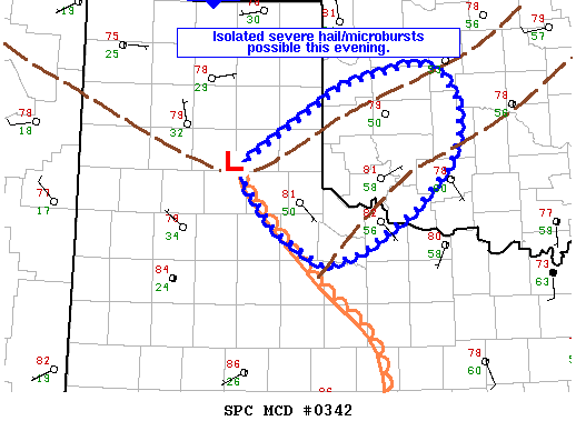
The graphic for Mesoscale Convective Discussion #342 issued by the Storm Prediction Center at 2153Z on March 30, 2013 (4:53 P.M. CDT). Courtesy of SPC.
At 4:53 P.M. CDT on Saturday, March 30, 2013, the Storm Prediction Center issued Mesoscale Discussion #342 (see graphic above), identifying mesoscale boundaries over the panhandle of Texas and a portion of Oklahoma as pretty safe bets to initiate thunderstorms that had the potential to produce severe weather (purpose of mesoscale discussions). The dashed, brown lines on the SPC graphic for MD #342 indicated the mesoscale boundaries (full text for MD #342). By the way, "342" refers to the running count of mesoscale discussions for the year.
During the daytime hours, forecasters often identify mesoscale boundaries using high-resolution visible satellite imagery. For this case, I annotated this 2145Z visible image from GOES-13 in order to highlight portions of the two mesoscale boundaries. To get a better sense for why I used the word, "subtle" in the context of mesoscale boundaries, check out this unannotated version. Here's an annotated close-up of the 2145Z visible image showing portions of the mesoscale boundaries over the panhandle of Texas and portions of Oklahoma.
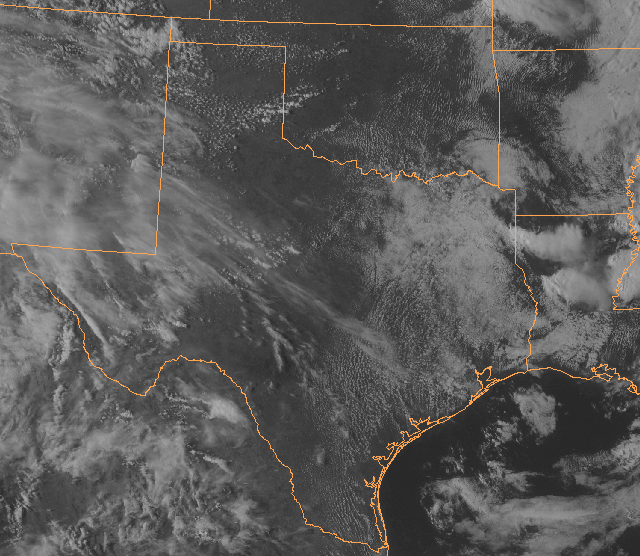
The 2145Z visible satellite image from GOES-13 on March 30, 2013. Can you find two mesoscale boundaries over the panhandle of Texas and portions of Oklahoma? Here's the answer. Courtesy of NOAA and Penn State.
About one hour later, deep, moist convection erupted along segments of the mesoscale boundaries (see the 2245Z visible image below). I circled the discrete thunderstorms in yellow. Farther south, you'll see more thunderstorms initiated by the dry line. I'll include the 21Z surface analysis so you can get a better sense for the position of the dry line around this time (late Saturday afternoon). Note how the storm anvils (photographs) spread toward the southeast in tandem with northwesterly upper-level winds (here's the GFS model analysis of 300-mb streamlines at 18Z on March 30; the standard height of 300 mb is 9000 meters, which is roughly 30,000 feet).
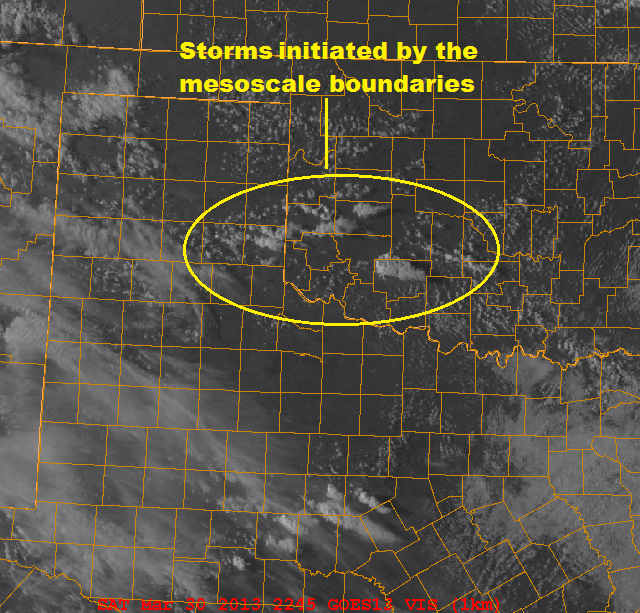
The 2245Z visible image from GOES-13 on March 30, 2013. The yellow circle encompasses thunderstorms that were initiated along two mesoscale boundaries over the Texas Panhandle and portions of Oklahoma.
As the warm season unfolds, I'll post blogs on mesoscale meteorology and forecasting. In the final analysis, "becoming one with the atmosphere" is the key philosophy for successfully predicting thunderstorms. The positions of synoptic-scale fronts and upper-level disturbances provide forecasters with the "big picture," but discovering subtle mesoscale boundaries can sometimes make a general thunderstorm forecast much more precise (with regard to location and timing).
Lee
Mesoscale Meteorology Mesoscale Forecasting
The views of the author are his/her own and do not necessarily represent the position of The Weather Company or its parent, IBM.