WunderBlog Archive » Category 6™
Category 6 has moved! See the latest from Dr. Jeff Masters and Bob Henson here.Guillermo Gathers Steam in NE Pacific; Invest 94L Clings to Life
Hurricane Guillermo is stepping up its game in the Northeast Pacific, as it moves along a steady west-northwest course that could bring it near the Hawaiian Islands next week. Guillermo was upgraded to hurricane status by the National Hurricane Center at 5:00 am EDT Friday, and in the NHC’s 11:00 am EDT advisory, Guillermo was located at 12.4°N, 132.7°W, with top sustained winds at 90 mph. Visible and infrared satellite imagery shows a healthy tropical cyclone, with extensive upper-level outflow, a distinct convective core, and a small eye beginning to take shape. Guillermo is successfully fending off an expanse of dry air to its north and maintaining an envelope of rich moisture.

Figure 1. A GOES West infrared satellite image of Hurricane Guillermo from 1630 GMT (12:30 pm EDT) on Friday, July 31. Image credit: NOAA/NESDIS.
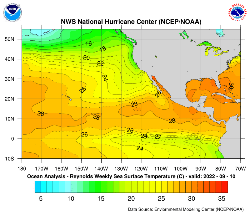
Guillermo is in a quite favorable environment to intensify further, with warm sea-surface temperatures and low wind shear. SSTs are around 28-29°C (82-84°F) along Guillermo’s path for the next day or so, which is 1-2°C above the climatological norm (see Figure 2). The oceanic heat content--the amount of energy in the uppermost part of the ocean--is rather low ahead of Guillermo, which could spell trouble for a slow-moving system churning up cooler water from below (see Figure 3). However, Guillermo is moving briskly (about 17 mph), and that pace is expected to continue for the next couple of days.

Figure 2. Departures from average sea-surface temperature over the Northeast Pacific for the week ending July 27, 2015. Image credit: NOAA National Hurricane Center.
It is still too soon to know how much of a threat Guillermo will pose to the Hawaiian Islands. The steering flow around Guillermo will be fairly stable over the next several days, keeping it on a track headed almost directly toward the islands. The NHC’s latest outlook places Guillermo located about a day away from the Big Island by early Wednesday morning. The most recent track models are in some disagreement over whether Guillermo will be picked up by a strong band of upper-level westerlies around this point, taking it well northeast of Hawaii; continue on its west-northwest track; or arc further westward, a path that could take it south of the islands. The disagreement is evident within the 1200 GMT Friday runs of the 20-member GFS ensemble (see Figure 3). As for intensity, Guillermo is likely to peak over the weekend, with NHC bringing the hurricane to low-end Category 3 strength (peak sustained winds of 115 mph) by Saturday. The unusually warm waters fostered by El Niño would keep Guillermo traveling over SSTs of at least 27°C (the rough threshold for sustaining a tropical cyclone) all the way to Hawaii. However, wind shear is expected to steadily increase as Giuillermo gains latitude and approaches the belt of upper-level westerlies noted above. Given its current track and intensity, and the increased climatological risk of hurricanes affecting Hawaii during El Niño, we will need to keep a close eye on Guillermo over the next few days. Twice-daily hurricane-hunter flights to monitor Guillermo have been slated beginning on Saturday, with the NOAA Gulfstream IV aircraft tentatively scheduled to sample the large-scale environment around Guillermo on Monday.

Figure 3. Projections for the track of Hurricane Guillermo produced on Friday morning by the 20-member GFS ensemble. The operational run is shown in white. Ensemble runs are produced by running the models at lower resolution than the operational run and varying the initial atmospheric conditions slightly to generate an "ensemble" of twenty potential weather situations, illustrating a range of possible outcomes.
Invest 94L shows little sign of strengthening
Invest 94L is still identifiable, but not very impressive, in the central North Atlantic. The loosely organized system was located around 12.5°N, 32.2°W at 8:00 am EDT Friday, moving west at about 15 mph. The circulation around 94L is highly elongated, with upper-level outflow evident but dry air invading the storm, leaving it with only weak shower and thunderstorm activity. The SHIPS statistical model brings 94L to moderate tropical-storm strength in the next several days, but none of the most reliable dynamical models for tropical cyclone formation indicate any substantial development of 94L, and NHC has lowered its five-day odds of development from 30% to 10%. Even if 94L managed to get a new lease on life in the central Atlantic, it would face largely hostile conditions as it continued west into the very high wind shear present across the Caribbean.

Figure 4. Infrared satellite image of Invest 94L (located at center left). Image credit: NOAA/NESDIS.
Soudelor a potential threat to Japan next week
Tropical Storm Soudelor should begin flexing its muscle over the next couple of days in the Northwest Pacific. Hindered over the last day by a tropical upper tropospheric trough (TUTT) to its north, Soudelor will soon escape the TUTT’s influence and likely launch into several days of significant strengthening. Soudelor’s peak winds were about 40 mph at 8:00 am EDT Friday, but the outlook issued by the Joint Typhoon Warning Center brings Soudelor’s winds to typhoon strength by Saturday and Category 4 strength (140 mph) by Monday. Track and intensity forecasts are increasingly uncertain beyond that point, as wind shear will be on the increase and water temperatures along Soudelor’s path will be cooler. It appears there is a good chance Soudelor will move far enough west to pose a potential threat to Japan later in the week.
Another off-season system pops up in the South Pacific
While our attention is focused on the peak season for tropical development in the Northern Hemisphere, Invest 91SH is defying seasonal expectations. The system was located at 7.8°S and 167.9°E at 8:00 am EDT Friday, moving slowly south-southeast with peak winds of around 23 mph. The 0600 GMT Friday run of the U.S. Navy’s version of the GFDN model brings Invest 91SH to tropical storm strength over the weekend before a weakening trend is projected to set in, well before the system approaches the islands of Vanuatu. A tropical storm in this basin in early August would be very unusual, as the official South Pacific season runs from November to April, but El Niño does tend to increase activity in the South Pacific. If 91SH does develop, it will be named Tuni and classified as the first South Pacific cyclone in the 2015-16 season. Another off-season system, Tropical Cyclone Raquel, formed at the end of June and intensified to Category 1 strength in early July, bringing at least one fatality and extensive damage to agriculture in the Solomon Islands. Raquel is the only tropical cyclone recorded to date in the South Pacific during July.
I’ll have another update by Monday at the latest. Wunderblogger Steve Gregory added a new post on Friday afternoon. We’re also pleased to welcome Dr. Phil Klotzbach (@philklotzbach) as a WU blogger. Phil worked with Dr. Bill Gray for many years on the Colorado State University seasonal hurricane forecasting project, and he is now lead author on those forecasts. In his first Weather Underground post, Phil weighs in on the multiple ways in which El Niño tends to inhibit Atlantic hurricanes.
Have a great weekend!
Bob
Figure 1. A GOES West infrared satellite image of Hurricane Guillermo from 1630 GMT (12:30 pm EDT) on Friday, July 31. Image credit: NOAA/NESDIS.
Guillermo is in a quite favorable environment to intensify further, with warm sea-surface temperatures and low wind shear. SSTs are around 28-29°C (82-84°F) along Guillermo’s path for the next day or so, which is 1-2°C above the climatological norm (see Figure 2). The oceanic heat content--the amount of energy in the uppermost part of the ocean--is rather low ahead of Guillermo, which could spell trouble for a slow-moving system churning up cooler water from below (see Figure 3). However, Guillermo is moving briskly (about 17 mph), and that pace is expected to continue for the next couple of days.
Figure 2. Departures from average sea-surface temperature over the Northeast Pacific for the week ending July 27, 2015. Image credit: NOAA National Hurricane Center.
It is still too soon to know how much of a threat Guillermo will pose to the Hawaiian Islands. The steering flow around Guillermo will be fairly stable over the next several days, keeping it on a track headed almost directly toward the islands. The NHC’s latest outlook places Guillermo located about a day away from the Big Island by early Wednesday morning. The most recent track models are in some disagreement over whether Guillermo will be picked up by a strong band of upper-level westerlies around this point, taking it well northeast of Hawaii; continue on its west-northwest track; or arc further westward, a path that could take it south of the islands. The disagreement is evident within the 1200 GMT Friday runs of the 20-member GFS ensemble (see Figure 3). As for intensity, Guillermo is likely to peak over the weekend, with NHC bringing the hurricane to low-end Category 3 strength (peak sustained winds of 115 mph) by Saturday. The unusually warm waters fostered by El Niño would keep Guillermo traveling over SSTs of at least 27°C (the rough threshold for sustaining a tropical cyclone) all the way to Hawaii. However, wind shear is expected to steadily increase as Giuillermo gains latitude and approaches the belt of upper-level westerlies noted above. Given its current track and intensity, and the increased climatological risk of hurricanes affecting Hawaii during El Niño, we will need to keep a close eye on Guillermo over the next few days. Twice-daily hurricane-hunter flights to monitor Guillermo have been slated beginning on Saturday, with the NOAA Gulfstream IV aircraft tentatively scheduled to sample the large-scale environment around Guillermo on Monday.
Figure 3. Projections for the track of Hurricane Guillermo produced on Friday morning by the 20-member GFS ensemble. The operational run is shown in white. Ensemble runs are produced by running the models at lower resolution than the operational run and varying the initial atmospheric conditions slightly to generate an "ensemble" of twenty potential weather situations, illustrating a range of possible outcomes.
Invest 94L shows little sign of strengthening
Invest 94L is still identifiable, but not very impressive, in the central North Atlantic. The loosely organized system was located around 12.5°N, 32.2°W at 8:00 am EDT Friday, moving west at about 15 mph. The circulation around 94L is highly elongated, with upper-level outflow evident but dry air invading the storm, leaving it with only weak shower and thunderstorm activity. The SHIPS statistical model brings 94L to moderate tropical-storm strength in the next several days, but none of the most reliable dynamical models for tropical cyclone formation indicate any substantial development of 94L, and NHC has lowered its five-day odds of development from 30% to 10%. Even if 94L managed to get a new lease on life in the central Atlantic, it would face largely hostile conditions as it continued west into the very high wind shear present across the Caribbean.
Figure 4. Infrared satellite image of Invest 94L (located at center left). Image credit: NOAA/NESDIS.
Soudelor a potential threat to Japan next week
Tropical Storm Soudelor should begin flexing its muscle over the next couple of days in the Northwest Pacific. Hindered over the last day by a tropical upper tropospheric trough (TUTT) to its north, Soudelor will soon escape the TUTT’s influence and likely launch into several days of significant strengthening. Soudelor’s peak winds were about 40 mph at 8:00 am EDT Friday, but the outlook issued by the Joint Typhoon Warning Center brings Soudelor’s winds to typhoon strength by Saturday and Category 4 strength (140 mph) by Monday. Track and intensity forecasts are increasingly uncertain beyond that point, as wind shear will be on the increase and water temperatures along Soudelor’s path will be cooler. It appears there is a good chance Soudelor will move far enough west to pose a potential threat to Japan later in the week.
Another off-season system pops up in the South Pacific
While our attention is focused on the peak season for tropical development in the Northern Hemisphere, Invest 91SH is defying seasonal expectations. The system was located at 7.8°S and 167.9°E at 8:00 am EDT Friday, moving slowly south-southeast with peak winds of around 23 mph. The 0600 GMT Friday run of the U.S. Navy’s version of the GFDN model brings Invest 91SH to tropical storm strength over the weekend before a weakening trend is projected to set in, well before the system approaches the islands of Vanuatu. A tropical storm in this basin in early August would be very unusual, as the official South Pacific season runs from November to April, but El Niño does tend to increase activity in the South Pacific. If 91SH does develop, it will be named Tuni and classified as the first South Pacific cyclone in the 2015-16 season. Another off-season system, Tropical Cyclone Raquel, formed at the end of June and intensified to Category 1 strength in early July, bringing at least one fatality and extensive damage to agriculture in the Solomon Islands. Raquel is the only tropical cyclone recorded to date in the South Pacific during July.
I’ll have another update by Monday at the latest. Wunderblogger Steve Gregory added a new post on Friday afternoon. We’re also pleased to welcome Dr. Phil Klotzbach (@philklotzbach) as a WU blogger. Phil worked with Dr. Bill Gray for many years on the Colorado State University seasonal hurricane forecasting project, and he is now lead author on those forecasts. In his first Weather Underground post, Phil weighs in on the multiple ways in which El Niño tends to inhibit Atlantic hurricanes.
Have a great weekend!
Bob
The views of the author are his/her own and do not necessarily represent the position of The Weather Company or its parent, IBM.