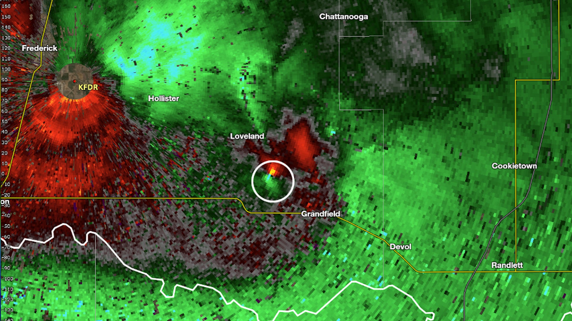
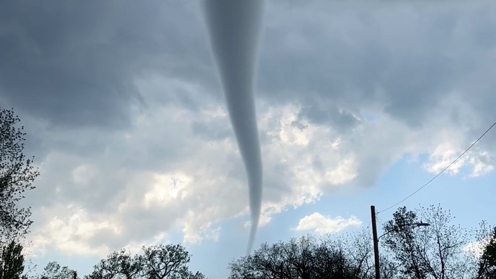
Tanjungpandan, Indonesia

4:12 PM WIT on May 24, 2013 (GMT +0700)
Elev: 144 ft
Lon: 107.8° E
Lat: 2.8° S
Rapid Fire Updates™
Updated 1:00 PM WIT - This station is not reporting! Get Free Weather Stickers® Share:
Your Custom Weather Sticker®

Copy the following lines of HTML:
Tropical Weather: Invest 91E (East Pacific)
News
May 23, 2013
Walk through the history of the U.S. space program with this huge archive of vintage photos from NASA's library of photographs taken throughout the history of manned flight, jet engine development, and the creation of the manned missions to the moon and the Space Shuttle program.
May 23, 2013
Four tourists in Iceland got an expected trip when they set up a picnic on a floating iceberg.
May 23, 2013
See the stories of just one block of families affected by the massive Oklahoma tornado.
May 23, 2013
Dollars-and-cents reality has resulted in a patchwork of protection for schools in tornado-prone areas sometimes with tragic results.
May 22, 2013
In the wake of the devastating tornado that struck Moore, Okla., teachers and educators emerge as heroes.
May 23, 2013
The Moore tornado may have been among the costliest in U.S. history. We count down the top 5 prior to this tornado.
May 22, 2013
The long, tornadic history of the Oklahoma City metro area.
May 22, 2013
Moore, Okla. tornado survivor Bernie Morris recalls the chaos and devastation of the May 20 twister that struck the area.
May 23, 2013
Officials say the focus is now on cleanup in the wake of the deadly EF5 tornado in Moore, Okla.
May 22, 2013
When a rare EF5 tornado hit Moore, Okla., on Monday afternoon, the citys medical professionals ran toward the destruction not away from it.
May 22, 2013
For survivors of Mondays devastating tornado that killed at least 24 and injured 120 more in suburban Oklahoma, the health threat might not end with the storm.
May 23, 2013
More flooding became a nuisance in North Dakota, creating worries of a possible dam break.
May 22, 2013
Two years after the EF5 tornado wrecked St. Johns Regional Medical Center in Joplin, construction continues on a new, sturdier hospital.
May 22, 2013
Photos reveal the terror after an EF5 tornado slammed Joplin in May 2011.
May 23, 2013
The Jersey Shore has made a remarkable comeback after being devastated by Hurricane Sandy. Now, it's ready to welcome tourists back to its shores.
May 23, 2013
Interactive map shows survey results from the National Weather Service.
May 22, 2013
With an ominous storm approaching, parents in Moore, Okla. had a heart-breaking choice to make:
May 22, 2013
The possibility that one child was left in the rubble of Plaza Towers Elementary School kept rescue crews working to sift through debris late Tuesday night.
May 22, 2013
Top lawmakers and officials said Tuesday that the federal government has plenty of money on hand to pay for recovery efforts in the wake of the devastating tornado that struck Oklahoma.
May 21, 2013
Students and parents recounted stories Tuesday of brave teachers who sheltered their pupils, in some cases by herding them into a closet and a restroom amid the fear and panic.
Weather Summary
Weather Underground Forecast for Friday, May 24, 2013. A storm will move away from Japan and into the Pacific Ocean Friday, allowing precipitation to gradually diminish in the country. A line of moisture will extend over the Ryukyu Islands and Taiwan, bringing scattered showers and thunderstorms to the area and adjacent areas of southeast China. Some of these thunderstorms will also pop up in the South China Sea, but no tropical development is expected through the tropical Pacific Ocean. Instead, typical tropical showers and thunderstorms will continue for Indonesia and the Philippines.

With regard to temperature, cool air will spill into the northern Sea of Japan, bringing mild daytime and overnight temperatures from the northern half of Honshu northward. A pocket of warm air will creep into the Korean Peninsula and adjacent areas of northern China, bringing warmer than normal temperatures to the area. Farther to the south, typical warm temperatures will bring a warm Spring day to the tropics.

Tokyo will rise into the upper 70s(F)/mid-20s(C), while Shanghai will see temperatures in the lower 80s(F)/upper 20s(C). Seoul will rise into the upper 70s(F)/mid-20s(C).

For Australia, a strong storm off the east coast of the country will bring heavy surf to the coast from Brisbane through Sydney. With regard to precipitation, showers will be possible for the coast, with the best chance of rain near Brisbane.

Meanwhile, a large high pressure system will move into the Great Australian Bight, spreading throughout much of the country and providing widespread dry conditions. Dry weather will even be possible for the north coast, as tropical thunderstorms will be pushed away from the coast.

Sydney will rise into the mid-60s(F)/upper 10s(C), while Melbourne will see temperatures in the lower 60s(F)/mid-10s(C). Brisbane will rise into the upper 60s(F)/lower 20s(C).

Tanjungpandan Weather at a Glance

Updated 1:00 PM WIT - This station is not reporting!
Elevation
144 ft
Report Station
You are about to report this weather station for bad data.

Please select the information which is incorrect and click 'Submit' otherwise click 'Cancel'.

Cancel

Now
Partly Cloudy
Partly Cloudy
Temperature
89 °F
Feels Like 89 °F
Wind(mph)
9
Sunrise / Set
5:46 AM
5:45 PM
Moon
Waxing Gibbous
Tonight
Chance of a Thunderstorm 75 °F
Chance of T-storms
40% chance of precipitation
Tomorrow
Thunderstorm 88 °F
T-storms
90% chance of precipitation
Tomorrow Night
Mostly Cloudy 73 °F
Mostly Cloudy
Sunday
Chance of a Thunderstorm 86 | 73 °F
Chance of T-storms
70% chance of precipitation
Monday
Chance of a Thunderstorm 86 | 75 °F
Chance of T-storms
30% chance of precipitation
Tuesday
Chance of a Thunderstorm 88 | 73 °F
Chance of T-storms
40% chance of precipitation
Tomorrow is forecast to be nearly the same temperature as today.
Conditions
Pressure
29.79 in
Visibility
6.0 miles
Clouds
Moisture
Humidity
51%
Rainfall
-
Snow Depth
Not available.
METAR
AAXX 24064 96249 32560 71808 10317 20230 30027 40088 57020 84332 333 56400 57941
Don't speak METAR? Read our FAQ.
Weather Radio
Temperature
Temperature
89 °F
Dew Point
73 °F
Wind
Speed / Dir
9 mph from South
Wind Gust
-
Health
Not available.
Pollen
Not available.
Air Quality
Not available.
Flu Activity
Not available.
Loading…
Source: BestForecast
Descriptive Forecast
Friday Night
nt_chancetstorms Overcast with a chance of a thunderstorm and rain after midnight. Fog overnight. Low of 75F. Winds less than 5 mph. Chance of rain 40%.
Saturday
tstorms Overcast with thunderstorms. High of 88F with a heat index of 93F. Winds less than 5 mph. Chance of rain 90% with rainfall amounts near 0.3 in. possible.
Saturday Night
nt_mostlycloudy Overcast. Low of 73F. Winds less than 5 mph.
Sunday
chancetstorms Overcast with a chance of a thunderstorm and rain. High of 86F. Winds less than 5 mph. Chance of rain 70% with rainfall amounts near 0.2 in. possible.
Sunday Night
nt_mostlycloudy Mostly cloudy with a chance of a thunderstorm and rain in the evening, then overcast. Low of 73F. Winds less than 5 mph.
Monday
chancetstorms Overcast in the morning, then mostly cloudy with a chance of a thunderstorm and rain. High of 86F. Winds less than 5 mph. Chance of rain 30%.
Monday Night
nt_cloudy Mostly cloudy in the evening, then overcast with a chance of a thunderstorm and rain. Low of 75F. Winds less than 5 mph. Chance of rain 20%.
Tuesday
chancetstorms Overcast with a chance of a thunderstorm and rain. High of 88F with a heat index of 93F. Winds less than 5 mph. Chance of rain 40%.
Tuesday Night
nt_cloudy Overcast with a chance of a thunderstorm. Fog overnight. Low of 73F. Winds from the SSE at 5 to 10 mph. Chance of rain 20%.
Wednesday
partlycloudy Partly cloudy with a chance of a thunderstorm. High of 88F with a heat index of 95F. Winds less than 5 mph. Chance of rain 20%.
Wednesday Night
nt_chancetstorms Partly cloudy with a chance of a thunderstorm. Fog overnight. Low of 75F. Winds from the SSE at 5 to 10 mph. Chance of rain 30%.
Thursday
chancetstorms Partly cloudy with a chance of a thunderstorm. High of 88F with a heat index of 93F. Winds less than 5 mph. Chance of rain 40%.
Thursday Night
nt_partlycloudy Partly cloudy with a chance of a thunderstorm. Fog overnight. Low of 75F. Winds less than 5 mph. Chance of rain 20%.
Friday
chancetstorms Partly cloudy with a chance of a thunderstorm. High of 86F. Winds less than 5 mph. Chance of rain 50%.
Friday Night
nt_partlycloudy Partly cloudy with a chance of a thunderstorm. Low of 75F. Winds less than 5 mph. Chance of rain 20%.
Saturday
chancetstorms Partly cloudy with a chance of a thunderstorm. High of 86F. Winds less than 5 mph. Chance of rain 40%.
Saturday Night
nt_chancetstorms Partly cloudy with a chance of a thunderstorm. Low of 73F. Winds less than 5 mph. Chance of rain 50% with rainfall amounts near 0.2 in. possible.
Sunday
chancetstorms Clear with a chance of a thunderstorm. High of 86F. Winds less than 5 mph. Chance of rain 50%.
Sunday Night
nt_clear Clear. Low of 75F. Winds less than 5 mph.
Monday
clear Clear. High of 88F. Winds less than 5 mph.
Monday Night
nt_clear Clear. Low of 75F. Winds less than 5 mph.

Radar imagery is not available for this location.


There are no webcams in your area.

Share your webcam with the world!

Nearby Weather Stations
There are no personal weather stations in this area.
webcam preview

Weather Forecast for Tanjungpandan Indonesia

View Calendar 7-Day Weather Forecast for Tanjungpandan

Friday, 24
Thunderstorm
88 | 75 °F
T-storms
Chance of
Precipitation
80%
Saturday, 25
Thunderstorm
88 | 73 °F
T-storms
Chance of
Precipitation
90%
Sunday, 26
Chance of a Thunderstorm
86 | 73 °F
Chance of T-storms
Chance of
Precipitation
70%
Monday, 27
Chance of a Thunderstorm
86 | 75 °F
Chance of T-storms
Chance of
Precipitation
30%
Tuesday, 28
Chance of a Thunderstorm
88 | 73 °F
Chance of T-storms
Chance of
Precipitation
40%
Wednesday, 29
Chance of a Thunderstorm
88 | 75 °F
Chance of a Thunderstorm
Chance of
Precipitation
20%
Thursday, 30
Chance of a Thunderstorm
88 | 75 °F
Chance of T-storms
Chance of
Precipitation
40%
Friday, 31
Chance of a Thunderstorm
86 | 75 °F
Chance of T-storms
Chance of
Precipitation
50%
Source: BestForecast at 3:20 PM WIT on May 24, 2013
Descriptive Forecast
Friday Night
nt_chancetstorms Overcast with a chance of a thunderstorm and rain after midnight. Fog overnight. Low of 75F. Winds less than 5 mph. Chance of rain 40%.
Hourly Forecast 6AM 12 Noon 6PM 12 Midnight
Temp. | Dew Point 78 | 73 83 | 74 78 | 75 79 | 75
Wind 3 mph SSE 4 mph East 5 mph NNE 2 mph North
Humidity 84% 74% 87% 85%
Chance of Precip. 10% 20% 50% 10%
Cloud Cover 99% 81% 95% 93%
Conditions Overcast Chance of Rain Thunderstorm Fog
Sunrise & Sunset
5:46 AM
5:45 PM
The quality of the forecasted high temperature for this day is excellent. MaxT RMSE [1.38], Average RMSE [0.99] : Use BestForecast
Source: BestForecast at 3:20 PM WIT on May 24, 2013
Descriptive Forecast
Saturday
tstorms Overcast with thunderstorms. High of 88F with a heat index of 93F. Winds less than 5 mph. Chance of rain 90% with rainfall amounts near 0.3 in. possible.
Saturday Night
nt_mostlycloudy Overcast. Low of 73F. Winds less than 5 mph.
Hourly Forecast 6AM 12 Noon 6PM 12 Midnight
Temp. | Dew Point 78 | 75 86 | 74 78 | 74 80 | 73
Wind 3 mph WSW 4 mph WSW 2 mph West 2 mph SSW
Humidity 89% 69% 89% 83%
Chance of Precip. 40% 30% 60% 10%
Cloud Cover 100% 100% 81% 98%
Conditions Chance of a Thunderstorm Chance of a Thunderstorm Thunderstorm Overcast
Sunrise & Sunset
5:46 AM
5:45 PM
The quality of the forecasted high temperature for this day is excellent. MaxT RMSE [1.32], Average RMSE [0.85] : Use BestForecast
Source: BestForecast at 3:20 PM WIT on May 24, 2013
Descriptive Forecast
Sunday
chancetstorms Overcast with a chance of a thunderstorm and rain. High of 86F. Winds less than 5 mph. Chance of rain 70% with rainfall amounts near 0.2 in. possible.
Sunday Night
nt_mostlycloudy Mostly cloudy with a chance of a thunderstorm and rain in the evening, then overcast. Low of 73F. Winds less than 5 mph.
Hourly Forecast 6AM 12 Noon 6PM 12 Midnight
Temp. | Dew Point 78 | 74 84 | 74 78 | 73 79 | 73
Wind 3 mph WSW 5 mph West 3 mph NNW 2 mph North
Humidity 89% 72% 86% 83%
Chance of Precip. 0% 30% 40% 10%
Cloud Cover 93% 95% 99% 73%
Conditions Overcast Chance of a Thunderstorm Chance of a Thunderstorm Mostly Cloudy
Sunrise & Sunset
5:46 AM
5:45 PM
The quality of the forecasted high temperature for this day is excellent. MaxT RMSE [1.29], Average RMSE [0.85] : Use BestForecast
Source: BestForecast at 3:20 PM WIT on May 24, 2013
Descriptive Forecast
Monday
chancetstorms Overcast in the morning, then mostly cloudy with a chance of a thunderstorm and rain. High of 86F. Winds less than 5 mph. Chance of rain 30%.
Monday Night
nt_cloudy Mostly cloudy in the evening, then overcast with a chance of a thunderstorm and rain. Low of 75F. Winds less than 5 mph. Chance of rain 20%.
Hourly Forecast 6AM 12 Noon 6PM 12 Midnight
Temp. | Dew Point 77 | 73 82 | 73 77 | 73 80 | 73
Wind 1 mph WNW 3 mph North 3 mph NNW 2 mph SSE
Humidity 88% 73% 89% 79%
Chance of Precip. 10% 0% 10% 10%
Cloud Cover 93% 84% 68% 89%
Conditions Overcast Mostly Cloudy Mostly Cloudy Overcast
Sunrise & Sunset
5:46 AM
5:45 PM
The quality of the forecasted high temperature for this day is excellent. MaxT RMSE [1.28], Average RMSE [0.96] : Use BestForecast
Source: BestForecast at 3:20 PM WIT on May 24, 2013
Descriptive Forecast
Tuesday
chancetstorms Overcast with a chance of a thunderstorm and rain. High of 88F with a heat index of 93F. Winds less than 5 mph. Chance of rain 40%.
Tuesday Night
nt_cloudy Overcast with a chance of a thunderstorm. Fog overnight. Low of 73F. Winds from the SSE at 5 to 10 mph. Chance of rain 20%.
Hourly Forecast 6AM 12 Noon 6PM 12 Midnight
Temp. | Dew Point 79 | 74 86 | 73 78 | 74 80 | 75
Wind 4 mph East 2 mph ESE 3 mph WSW 4 mph SE
Humidity 90% 65% 89% 84%
Chance of Precip. 20% 20% 10% 0%
Cloud Cover 98% 68% 100% 100%
Conditions Chance of a Thunderstorm Chance of a Thunderstorm Overcast Fog
Sunrise & Sunset
5:46 AM
5:45 PM
The quality of the forecasted high temperature for this day is excellent. MaxT RMSE [1.35], Average RMSE [1.03] : Use BestForecast
Source: BestForecast at 3:20 PM WIT on May 24, 2013
Descriptive Forecast
Wednesday
partlycloudy Partly cloudy with a chance of a thunderstorm. High of 88F with a heat index of 95F. Winds less than 5 mph. Chance of rain 20%.
Wednesday Night
nt_chancetstorms Partly cloudy with a chance of a thunderstorm. Fog overnight. Low of 75F. Winds from the SSE at 5 to 10 mph. Chance of rain 30%.
Hourly Forecast 6AM 12 Noon 6PM 12 Midnight
Temp. | Dew Point 79 | 75 86 | 75 78 | 75 80 | 75
Wind 6 mph SSE 4 mph SSE 5 mph SE 6 mph SSE
Humidity 92% 68% 90% 88%
Chance of Precip. 20% 10% 10% 10%
Cloud Cover 97% 78% 54% 26%
Conditions Chance of a Thunderstorm Mostly Cloudy Partly Cloudy Fog
Sunrise & Sunset
5:47 AM
5:45 PM
The quality of the forecasted high temperature for this day is excellent. MaxT RMSE [1.40], Average RMSE [1.06] : Use BestForecast
Source: BestForecast at 3:20 PM WIT on May 24, 2013
Descriptive Forecast
Thursday
chancetstorms Partly cloudy with a chance of a thunderstorm. High of 88F with a heat index of 93F. Winds less than 5 mph. Chance of rain 40%.
Thursday Night
nt_partlycloudy Partly cloudy with a chance of a thunderstorm. Fog overnight. Low of 75F. Winds less than 5 mph. Chance of rain 20%.
Hourly Forecast 6AM 12 Noon 6PM 12 Midnight
Temp. | Dew Point 78 | 75 85 | 73 78 | 75 79 | 75
Wind 4 mph South 3 mph South 5 mph SSW 5 mph SSE
Humidity 90% 68% 88% 87%
Chance of Precip. 30% 30% 20% 10%
Cloud Cover 39% 64% 27% 51%
Conditions Chance of a Thunderstorm Chance of a Thunderstorm Chance of a Thunderstorm Fog
Sunrise & Sunset
5:47 AM
5:45 PM
The quality of the forecasted high temperature for this day is good. MaxT RMSE [1.57], Average RMSE [1.17] : Use BestForecast
Source: BestForecast at 3:20 PM WIT on May 24, 2013
Descriptive Forecast
Friday
chancetstorms Partly cloudy with a chance of a thunderstorm. High of 86F. Winds less than 5 mph. Chance of rain 50%.
Friday Night
nt_partlycloudy Partly cloudy with a chance of a thunderstorm. Low of 75F. Winds less than 5 mph. Chance of rain 20%.
Hourly Forecast 6AM 12 Noon 6PM 12 Midnight
Temp. | Dew Point 78 | 75 86 | 73 79 | 73 80 | 73
Wind 3 mph SE 2 mph SW 2 mph NW 1 mph SSE
Humidity 89% 65% 84% 82%
Chance of Precip. 20% 20% 20% 10%
Cloud Cover 57% 48% 47% 42%
Conditions Chance of a Thunderstorm Chance of a Thunderstorm Chance of a Thunderstorm Partly Cloudy
Sunrise & Sunset
Sun does not rise
The quality of the forecasted high temperature for this day is excellent. MaxT RMSE [1.28], Average RMSE [1.20] : Use BestForecast
Source: BestForecast at 3:20 PM WIT on May 24, 2013
Descriptive Forecast
Saturday
chancetstorms Partly cloudy with a chance of a thunderstorm. High of 86F. Winds less than 5 mph. Chance of rain 40%.
Saturday Night
nt_chancetstorms Partly cloudy with a chance of a thunderstorm. Low of 73F. Winds less than 5 mph. Chance of rain 50% with rainfall amounts near 0.2 in. possible.
Hourly Forecast 6AM 12 Noon 6PM 12 Midnight
Temp. | Dew Point 79 | 73 86 | 73 78 | 74 79 | 73
Wind 1 mph SSE 0 mph ESE 2 mph SE 1 mph SSE
Humidity 85% 68% 89% 84%
Chance of Precip. 10% 10% 10% 10%
Cloud Cover 33% 32% 39% 43%
Conditions Partly Cloudy Partly Cloudy Partly Cloudy Partly Cloudy
Sunrise & Sunset
Sun does not rise
Source: BestForecast at 3:20 PM WIT on May 24, 2013
Descriptive Forecast
Sunday
chancetstorms Clear with a chance of a thunderstorm. High of 86F. Winds less than 5 mph. Chance of rain 50%.
Sunday Night
nt_clear Clear. Low of 75F. Winds less than 5 mph.
Hourly Forecast 6AM 12 Noon 6PM 12 Midnight
Temp. | Dew Point 79 | 73 86 | 73 78 | 73 79 | -9998
Wind 3 mph SSE 1 mph SE 2 mph SE 2 mph SE
Humidity 84% 66% 85% -9998%
Chance of Precip. 10% 10% 10% 10%
Cloud Cover 43% % % %
Conditions Partly Cloudy Clear Clear Clear
Sunrise & Sunset
Sun does not rise
Source: BestForecast at 3:20 PM WIT on May 24, 2013
Descriptive Forecast
Monday
clear Clear. High of 88F. Winds less than 5 mph.
Monday Night
nt_clear Clear. Low of 75F. Winds less than 5 mph.
Hourly Forecast 6AM 12 Noon 6PM 12 Midnight
Temp. | Dew Point 79 | 73 86 | 73 78 | 73 79 | 73
Wind 3 mph SSE 1 mph SE 2 mph SE 2 mph SSE
Humidity 84% 66% 85% 84%
Chance of Precip. 10% 10% 10% 0%
Cloud Cover 43% % % %
Conditions Partly Cloudy Clear Clear Clear
Sunrise & Sunset
Sun does not rise
 
Nearby
History & Almanac
Yesterday 1830 °F
Choose a date
Astronomy
May. 24, 2013 Rise Set
Actual Time 5:46 AM WIT 5:45 PM WIT
Civil Twilight 5:24 AM WIT 6:07 PM WIT
Nautical Twilight 4:58 AM WIT 6:33 PM WIT
Astronomical Twilight 4:32 AM WIT 6:58 PM WIT
Moon 4:59 PM WIT 4:35 AM WIT
Length Of Visible Light 12h 43m
Length of Day
11h 58m
Tomorrow will be 0m 4s shorter.
Waxing Gibbous, 99% of the Moon is Illuminated
Today
Waxing Gibbous
May 25
Full
Jun 1
Last Quarter
Jun 8
New
Jun 17
First Quarter
Yesterday's Extremes
Country Highs Country Lows
94 °F
Pakanbaru
93 °F
Palu
93 °F
Kolaka
56 °F
Enarotali
59 °F
Wamena
63 °F
Ruteng
65 °F
Citeko
66 °F
Kerinci
WunderPhotos®
Sunset
Lake Monroe Lightning.
Uploaded by: LarryD
1,614,441 photos uploaded!
WunderBlogs®

There are no recent blogs in this area. Why not create your own?

Travel & Activities
Travel Planning
Destination? *
When are you going?
to
Is there an activity you would like to explore?
* Required field
Aviation
City Temp. Conditions Updated
Tanjungpandan / Buluh Tumbang 89 °F Partly Cloudy 1:00 PM WIT
Flight To ETA Status
No flights were found.
Flight Tracker by FlightAware FlightAware
Type Condition
Flight Rule: VFR ()
Wind Speed: 8.0 kts.
Wind Dir: 180° (South)
Ceiling: 100000 ft

AAXX 24064 96249 32560 71808 10317 20230 30027 40088 57020 84332 333 56400 57941

Videos
Year In Weather 2012

Watch the nearly year-long satellite animation as Weather Underground calls out the most significant weather events of the past year, including Superstorm Sandy and Hurricane Isaac.

Weather Stations

There are no personal weather stations in this area.