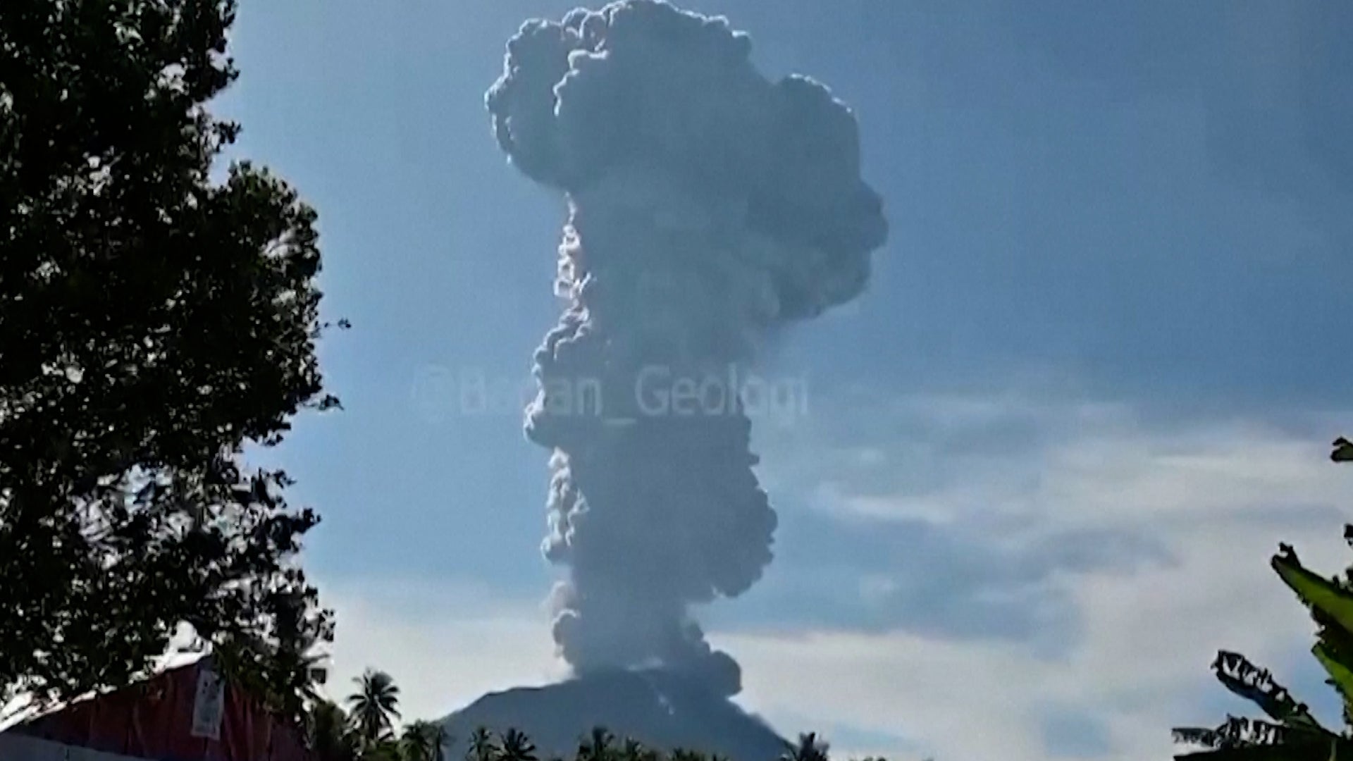
Albany, Western Australia

11:47 AM WST on May 25, 2013 (GMT +0800)
Elev: 233 ft
Lon: 117.8° E
Lat: 34.9° S
Rapid Fire Updates™
Updated 11:00 AM WST Get Free Weather Stickers® Share:
Your Custom Weather Sticker®

Copy the following lines of HTML:
Tropical Weather: Invest 91E (East Pacific)
News
May 24, 2013
Another severe weather outbreak is possible in the Plains next week.
May 24, 2013
The potential of tornadoes on May 20, 2013 was well forecast, likely saving many more lives in the Moore tornado.
May 24, 2013
It was early Thursday afternoon at the makeshift animal shelter at the Cleveland County, Okla. Fairgrounds, and Erin Brickman had yet to sleep from the night before.
May 24, 2013
This Memorial Day weekend, 31.2 million Americans will drive 50 miles or more to a beach, campground or other getaway, according to car lobbying group AAA.
May 24, 2013
Tragedy is feared on one of the world's tallest peaks.
May 24, 2013
An earthquake in far northeastern California was felt by thousands of people as far away as San Francisco.
May 24, 2013
A survivor describes the horrifying ordeal that occurred Thursday night in Washington.
May 23, 2013
Officials are being attacked by residents in India because of a nasty heat wave.
May 23, 2013
There's a new record for the oldest person to scale Mount Everest, but it might not last long.
May 24, 2013
Blake Shelton and Carrie Underwood are planning ways to help those devastated in Oklahoma.
May 23, 2013
The young victims of the Moore, Okla. tornado are being remembered by grieving parents.
May 24, 2013
Walk through the history of the U.S. space program with this huge archive of vintage photos from NASA's library of photographs taken throughout the history of manned flight, jet engine development, and the creation of the manned missions to the moon and the Space Shuttle program.
May 23, 2013
Four tourists in Iceland got an expected trip when they set up a picnic on a floating iceberg.
May 22, 2013
In the wake of the devastating tornado that struck Moore, Okla., teachers and educators emerge as heroes.
May 23, 2013
The Moore tornado may have been among the costliest in U.S. history. We count down the top 5 prior to this tornado.
May 24, 2013
The long, tornadic history of the Oklahoma City metro area.
May 22, 2013
Moore, Okla. tornado survivor Bernie Morris recalls the chaos and devastation of the May 20 twister that struck the area.
May 23, 2013
There were far fewer homes damaged than originally believed, according to officials.
May 22, 2013
When a rare EF5 tornado hit Moore, Okla., on Monday afternoon, the citys medical professionals ran toward the destruction not away from it.
May 22, 2013
For survivors of Mondays devastating tornado that killed at least 24 and injured 120 more in suburban Oklahoma, the health threat might not end with the storm.
Weather Summary
Weather Underground Forecast for Saturday, May 25, 2013.

Active weather will persist for most of China on Saturday as a strong low pressure system develops over western China. The system will strengthen as it moves off the Tibetan Plateau and pulls moisture northward from the South China Sea. This will produce moderate to heavy showers and thunderstorms from northern Vietnam through Chongqing and into Shaanxi. Expect strong storms with periods of heavy rainfall and strong winds. Flooding and landslides may accompany this system. To the south, strong storms with heavy rainfall will develop to the south from Banglades through Myanmar and Laos, but is not expected to spread throughout Indochina. Hong Kong will see showers and thunderstorms with highs near 90(F)/ 32(C), while Beijing will be partly cloudy with a chance of rain late and highs in the lower 70s(F)/ lower 20s(C). In the east, a ridge of high pressure over the Sea of Japan advances eastward on Saturday. However, a weak trough of low pressure embedded in this ridge will push some moisture into central and eastern Japan, bringing chances of showers to the region. Tokyo will be partly cloudy with a chance of rain and highs in the mid-70s(F)/ lower 20s(C).

In Australia, a broad ridge of high pressure stretches northward from the Great Australian Bight, maintaining dry and warm weather for most of the country. However in the east, onshore flow from the east may bring a few coastal showers to New South Wales. Sydney will remain mostly sunny and dry with highs in the upper 60s(F)/ near 20(C).

Albany Weather at a Glance

Updated 11:00 AM WST
Weather Station
Elevation
233 ft
Report Station
You are about to report this weather station for bad data.

Please select the information which is incorrect and click 'Submit' otherwise click 'Cancel'.

Cancel

Now
Clear
Clear
Temperature
63 °F
Feels Like 63 °F
Wind(mph)
8
Sunrise / Set
7:03 AM
5:08 PM
Moon
Full
Today
Clear 64 °F
Clear
Tonight
Clear 50 °F
Clear
Tomorrow
Partly Cloudy 68 | 48 °F
Partly Cloudy
Monday
Partly Cloudy 68 | 52 °F
Partly Cloudy
Tuesday
Partly Cloudy 66 | 50 °F
Partly Cloudy
Wednesday
Partly Cloudy 66 | 52 °F
Partly Cloudy
Today is forecast to be nearly the same temperature as yesterday.
Conditions
Pressure
30.21 in
Visibility
-
Clouds
Moisture
Humidity
46%
Rainfall
-
Snow Depth
Not available.
METAR
AAXX 25034 94802 46/// /0507 10171 20085 30145 40228
Don't speak METAR? Read our FAQ.
Weather Radio
Temperature
Temperature
63 °F
Dew Point
47 °F
Wind
Speed / Dir
8 mph from NE
Wind Gust
-
Health
Not available.
Pollen
Not available.
Air Quality
Not available.
Flu Activity
Not available.
Loading…
Source: BestForecast
Descriptive Forecast
Saturday
clear Clear. High of 64F. Winds from the NE at 5 to 10 mph.
Saturday Night
nt_clear Clear in the evening, then partly cloudy. Low of 50F. Winds from the NNE at 5 to 10 mph.
Sunday
partlycloudy Clear in the morning, then partly cloudy. High of 68F. Winds less than 5 mph.
Sunday Night
nt_clear Clear in the evening, then partly cloudy. Low of 48F. Winds from the North at 5 to 10 mph.
Monday
partlycloudy Mostly cloudy. High of 68F. Winds from the NW at 5 to 10 mph.
Monday Night
nt_partlycloudy Partly cloudy in the evening, then overcast. Low of 52F. Winds from the NNW at 5 to 10 mph.
Tuesday
partlycloudy Overcast in the morning, then partly cloudy. High of 66F. Winds from the North at 5 to 10 mph.
Tuesday Night
nt_partlycloudy Partly cloudy with a chance of rain. Fog overnight. Low of 50F. Winds from the NW at 10 to 15 mph. Chance of rain 20%.
Wednesday
partlycloudy Partly cloudy. High of 66F. Breezy. Winds from the NW at 10 to 20 mph.
Wednesday Night
nt_chancerain Overcast with a chance of rain. Low of 52F. Breezy. Winds from the NNW at 10 to 20 mph. Chance of rain 60%.
Thursday
chancetstorms Partly cloudy with a chance of a thunderstorm. High of 63F. Breezy. Winds from the NW at 15 to 20 mph. Chance of rain 50%.
Thursday Night
nt_mostlycloudy Mostly cloudy. Low of 52F. Breezy. Winds from the NW at 15 to 25 mph.
Friday
chancerain Mostly cloudy with a chance of rain. High of 63F. Breezy. Winds from the West at 15 to 25 mph. Chance of rain 50%.
Friday Night
nt_partlycloudy Clear with a chance of rain. Low of 48F. Winds from the West at 10 to 15 mph. Chance of rain 20%.
Saturday
clear Clear. High of 64F. Winds from the SSW at 5 to 15 mph.
Saturday Night
nt_partlycloudy Clear. Fog overnight. Low of 46F. Winds less than 5 mph.
Sunday
partlycloudy Partly cloudy. High of 64F. Winds less than 5 mph.
Sunday Night
nt_partlycloudy Partly cloudy. Low of 46F. Winds less than 5 mph.
Monday
mostlycloudy Mostly cloudy. High of 63F. Winds less than 5 mph.
Monday Night
nt_mostlycloudy Overcast. Low of 46F. Winds less than 5 mph.
Tuesday
partlycloudy Clear. High of 63F. Winds less than 5 mph.
Tuesday Night
nt_clear Clear. Fog overnight. Low of 46F. Winds less than 5 mph.
Loading…
 

There are no webcams in your area.

Share your webcam with the world!

Nearby Weather Stations
There are no personal weather stations in this area.
webcam preview

Weather Forecast for Albany Western Australia

View Calendar 7-Day Weather Forecast for Albany

Saturday, 25
Clear
64 | 50 °F
Clear
Chance of
Precipitation
0%
Sunday, 26
Partly Cloudy
68 | 48 °F
Partly Cloudy
Chance of
Precipitation
0%
Monday, 27
Partly Cloudy
68 | 52 °F
Partly Cloudy
Chance of
Precipitation
0%
Tuesday, 28
Partly Cloudy
66 | 50 °F
Partly Cloudy
Chance of
Precipitation
0%
Wednesday, 29
Partly Cloudy
66 | 52 °F
Partly Cloudy
Chance of
Precipitation
0%
Thursday, 30
Chance of a Thunderstorm
63 | 52 °F
Chance of T-storms
Chance of
Precipitation
50%
Friday, 31
Chance of Rain
63 | 48 °F
Chance of Rain
Chance of
Precipitation
50%
Saturday, 1
Clear
64 | 46 °F
Clear
Chance of
Precipitation
0%
Source: BestForecast at 5:08 AM WST on May 25, 2013
Descriptive Forecast
Saturday
clear Clear. High of 64F. Winds from the NE at 5 to 10 mph.
Saturday Night
nt_clear Clear in the evening, then partly cloudy. Low of 50F. Winds from the NNE at 5 to 10 mph.
Hourly Forecast 6AM 12 Noon 6PM 12 Midnight
Temp. | Dew Point 51 | 48 62 | 48 57 | 46 53 | 46
Wind 7 mph NNE 8 mph NE 8 mph ENE 8 mph NE
Humidity 88% 59% 67% 78%
Chance of Precip. 0% 0% 0% 0%
Cloud Cover 0% 0% 0% 6%
Conditions Clear Clear Clear Clear
Sunrise & Sunset
7:03 AM
5:08 PM
The quality of the forecasted high temperature for this day is excellent. MaxT RMSE [1.07], Average RMSE [1.58] : Use BestForecast
Source: BestForecast at 5:08 AM WST on May 25, 2013
Descriptive Forecast
Sunday
partlycloudy Clear in the morning, then partly cloudy. High of 68F. Winds less than 5 mph.
Sunday Night
nt_clear Clear in the evening, then partly cloudy. Low of 48F. Winds from the North at 5 to 10 mph.
Hourly Forecast 6AM 12 Noon 6PM 12 Midnight
Temp. | Dew Point 51 | 45 64 | 47 57 | 49 54 | 46
Wind 7 mph NNE 5 mph NNE 5 mph NE 7 mph North
Humidity 77% 55% 72% 70%
Chance of Precip. 0% 0% 0% 0%
Cloud Cover 34% 25% 19% 0%
Conditions Partly Cloudy Clear Clear Clear
Sunrise & Sunset
7:03 AM
5:07 PM
The quality of the forecasted high temperature for this day is excellent. MaxT RMSE [1.35], Average RMSE [1.81] : Use BestForecast
Source: BestForecast at 5:08 AM WST on May 25, 2013
Descriptive Forecast
Monday
partlycloudy Mostly cloudy. High of 68F. Winds from the NW at 5 to 10 mph.
Monday Night
nt_partlycloudy Partly cloudy in the evening, then overcast. Low of 52F. Winds from the NNW at 5 to 10 mph.
Hourly Forecast 6AM 12 Noon 6PM 12 Midnight
Temp. | Dew Point 54 | 46 67 | 51 62 | 55 57 | 54
Wind 8 mph NNW 9 mph NNW 5 mph WNW 7 mph NW
Humidity 74% 57% 79% 89%
Chance of Precip. 0% 0% 10% 0%
Cloud Cover 53% 53% 60% 64%
Conditions Partly Cloudy Partly Cloudy Partly Cloudy Mostly Cloudy
Sunrise & Sunset
7:04 AM
5:07 PM
The quality of the forecasted high temperature for this day is excellent. MaxT RMSE [1.16], Average RMSE [2.12] : Use BestForecast
Source: BestForecast at 5:08 AM WST on May 25, 2013
Descriptive Forecast
Tuesday
partlycloudy Overcast in the morning, then partly cloudy. High of 66F. Winds from the North at 5 to 10 mph.
Tuesday Night
nt_partlycloudy Partly cloudy with a chance of rain. Fog overnight. Low of 50F. Winds from the NW at 10 to 15 mph. Chance of rain 20%.
Hourly Forecast 6AM 12 Noon 6PM 12 Midnight
Temp. | Dew Point 55 | 52 64 | 54 59 | 54 55 | 54
Wind 6 mph NNW 6 mph NNE 7 mph NW 14 mph NW
Humidity 92% 68% 85% 95%
Chance of Precip. 0% 0% 10% 10%
Cloud Cover 93% 87% 43% 69%
Conditions Overcast Mostly Cloudy Partly Cloudy Fog
Sunrise & Sunset
7:05 AM
5:06 PM
The quality of the forecasted high temperature for this day is excellent. MaxT RMSE [1.48], Average RMSE [2.05] : Use BestForecast
Source: BestForecast at 5:08 AM WST on May 25, 2013
Descriptive Forecast
Wednesday
partlycloudy Partly cloudy. High of 66F. Breezy. Winds from the NW at 10 to 20 mph.
Wednesday Night
nt_chancerain Overcast with a chance of rain. Low of 52F. Breezy. Winds from the NNW at 10 to 20 mph. Chance of rain 60%.
Hourly Forecast 6AM 12 Noon 6PM 12 Midnight
Temp. | Dew Point 54 | 51 64 | 48 59 | 48 55 | 53
Wind 14 mph WNW 15 mph NW 13 mph NNW 14 mph NNW
Humidity 87% 56% 67% 87%
Chance of Precip. 10% 0% 0% 20%
Cloud Cover 0% 0% 96% 86%
Conditions Clear Clear Overcast Chance of Rain
Sunrise & Sunset
7:05 AM
5:06 PM
The quality of the forecasted high temperature for this day is good. MaxT RMSE [2.15], Average RMSE [1.94] : Use BestForecast
Source: BestForecast at 5:08 AM WST on May 25, 2013
Descriptive Forecast
Thursday
chancetstorms Partly cloudy with a chance of a thunderstorm. High of 63F. Breezy. Winds from the NW at 15 to 20 mph. Chance of rain 50%.
Thursday Night
nt_mostlycloudy Mostly cloudy. Low of 52F. Breezy. Winds from the NW at 15 to 25 mph.
Hourly Forecast 6AM 12 Noon 6PM 12 Midnight
Temp. | Dew Point 54 | 53 62 | 50 57 | 47 52 | 46
Wind 11 mph NW 16 mph NW 17 mph NW 20 mph NW
Humidity 94% 63% 71% 79%
Chance of Precip. 30% 20% 20% 10%
Cloud Cover 100% 37% 95% 58%
Conditions Chance of Rain Chance of a Thunderstorm Chance of Rain Partly Cloudy
Sunrise & Sunset
7:06 AM
5:05 PM
The quality of the forecasted high temperature for this day is good. MaxT RMSE [2.35], Average RMSE [2.24] : Use BestForecast
Source: BestForecast at 5:08 AM WST on May 25, 2013
Descriptive Forecast
Friday
chancerain Mostly cloudy with a chance of rain. High of 63F. Breezy. Winds from the West at 15 to 25 mph. Chance of rain 50%.
Friday Night
nt_partlycloudy Clear with a chance of rain. Low of 48F. Winds from the West at 10 to 15 mph. Chance of rain 20%.
Hourly Forecast 6AM 12 Noon 6PM 12 Midnight
Temp. | Dew Point 52 | 46 63 | 47 57 | 49 53 | 46
Wind 20 mph WNW 21 mph West 14 mph WSW 11 mph West
Humidity 79% 58% 76% 84%
Chance of Precip. 10% 10% 30% 10%
Cloud Cover 42% 61% 91% 0%
Conditions Partly Cloudy Partly Cloudy Chance of Rain Clear
Sunrise & Sunset
7:07 AM
5:05 PM
The quality of the forecasted high temperature for this day is good. MaxT RMSE [1.56], Average RMSE [2.53] : Use BestForecast
Source: BestForecast at 5:08 AM WST on May 25, 2013
Descriptive Forecast
Saturday
clear Clear. High of 64F. Winds from the SSW at 5 to 15 mph.
Saturday Night
nt_partlycloudy Clear. Fog overnight. Low of 46F. Winds less than 5 mph.
Hourly Forecast 6AM 12 Noon 6PM 12 Midnight
Temp. | Dew Point 51 | 48 63 | 50 57 | 51 53 | 52
Wind 10 mph WNW 1 mph West 2 mph East 3 mph NE
Humidity 87% 61% 81% 93%
Chance of Precip. 10% 0% 0% 0%
Cloud Cover 5% 8% 21% 25%
Conditions Clear Clear Clear Fog
Sunrise & Sunset
Sun does not rise
The quality of the forecasted high temperature for this day is good. MaxT RMSE [1.56], Average RMSE [2.40] : Use BestForecast
Source: BestForecast at 5:08 AM WST on May 25, 2013
Descriptive Forecast
Sunday
partlycloudy Partly cloudy. High of 64F. Winds less than 5 mph.
Sunday Night
nt_partlycloudy Partly cloudy. Low of 46F. Winds less than 5 mph.
Hourly Forecast 6AM 12 Noon 6PM 12 Midnight
Temp. | Dew Point 55 | 51 63 | 52 57 | 50 53 | 50
Wind 4 mph NNE 2 mph NNE 3 mph NE 4 mph NNE
Humidity 89% 65% 78% 88%
Chance of Precip. 0% 0% 0% 0%
Cloud Cover 22% 30% 48% 63%
Conditions Clear Partly Cloudy Partly Cloudy Partly Cloudy
Sunrise & Sunset
Sun does not rise
Source: BestForecast at 5:08 AM WST on May 25, 2013
Descriptive Forecast
Monday
mostlycloudy Mostly cloudy. High of 63F. Winds less than 5 mph.
Monday Night
nt_mostlycloudy Overcast. Low of 46F. Winds less than 5 mph.
Hourly Forecast 6AM 12 Noon 6PM 12 Midnight
Temp. | Dew Point 53 | 48 60 | 48 57 | 47 53 | 47
Wind 5 mph North 2 mph North 2 mph North 4 mph North
Humidity 83% 62% 71% 82%
Chance of Precip. 0% 0% 0% 0%
Cloud Cover 75% 84% 90% 92%
Conditions Mostly Cloudy Mostly Cloudy Overcast Overcast
Sunrise & Sunset
Sun does not rise
Source: BestForecast at 5:08 AM WST on May 25, 2013
Descriptive Forecast
Tuesday
partlycloudy Clear. High of 63F. Winds less than 5 mph.
Tuesday Night
nt_clear Clear. Fog overnight. Low of 46F. Winds less than 5 mph.
Hourly Forecast 6AM 12 Noon 6PM 12 Midnight
Temp. | Dew Point 53 | 48 63 | 49 55 | 52 52 | 50
Wind 5 mph NNW 4 mph NW 3 mph West 3 mph WNW
Humidity 80% 62% 85% 93%
Chance of Precip. 0% 0% 0% 0%
Cloud Cover 90% % % %
Conditions Overcast Clear Clear Fog
Sunrise & Sunset
Sun does not rise
 
Nearby
History & Almanac
Yesterday 1830 °F
Choose a date
Astronomy
May. 25, 2013 Rise Set
Actual Time 7:03 AM WST 5:08 PM WST
Civil Twilight 6:35 AM WST 5:35 PM WST
Nautical Twilight 6:04 AM WST 6:06 PM WST
Astronomical Twilight 5:34 AM WST 6:36 PM WST
Moon 5:22 PM WST 6:48 AM WST
Length Of Visible Light 10h 59m
Length of Day
10h 04m
Tomorrow will be 1m 9s shorter.
Full, 100% of the Moon is Illuminated
Today
Full
May 25
Full
Jun 1
Last Quarter
Jun 8
New
Jun 17
First Quarter
Yesterday's Extremes
Country Highs Country Lows
90 °F
Curtin
89 °F
Kalumburu
89 °F
Wyndham
89 °F
Derby
26 °F
Mt Hotham
27 °F
Barren Tier
27 °F
Falls Creek
WunderPhotos®
Lucky Moon II
Evening Light
Uploaded by: SunsetSailor
1,614,716 photos uploaded!
WunderBlogs®

There are no recent blogs in this area. Why not create your own?

Travel & Activities
Travel Planning
Destination? *
When are you going?
to
Is there an activity you would like to explore?
* Required field
Aviation
City Temp. Conditions Updated
Albany Airport 63 °F 11:00 AM WST
Flight To ETA Status
No flights were found.
Flight Tracker by FlightAware FlightAware
Type Condition
Flight Rule: NA
Wind Speed: 7.0 kts.
Wind Dir: 50° (NE)
Ceiling: -

AAXX 25034 94802 46/// /0507 10171 20085 30145 40228

Videos
Year In Weather 2012

Watch the nearly year-long satellite animation as Weather Underground calls out the most significant weather events of the past year, including Superstorm Sandy and Hurricane Isaac.

Weather Stations

There are no personal weather stations in this area.