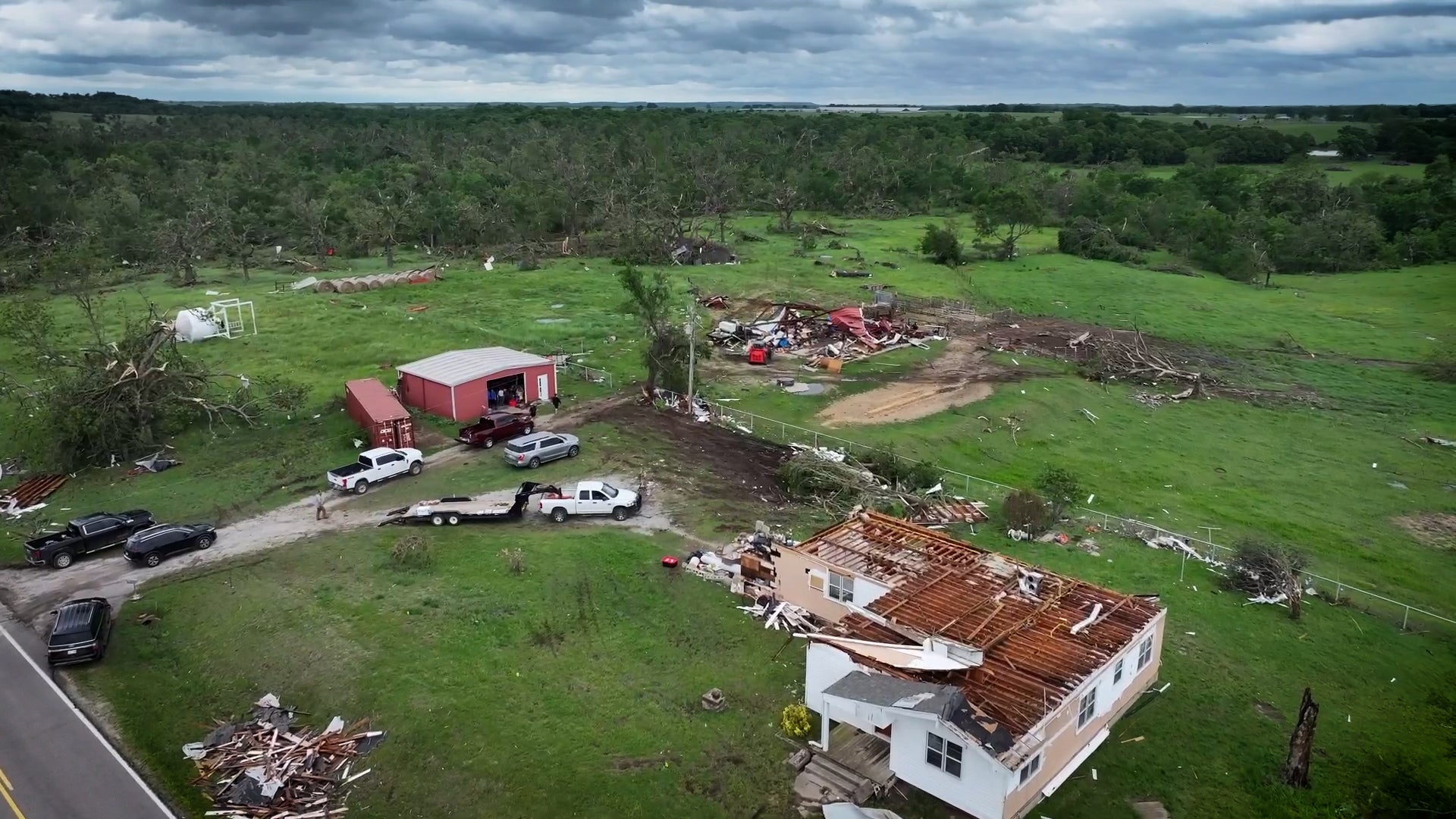
Guna, India

8:31 PM IST on February 11, 2012 (GMT +0530)
Elev: 1568 ft
Lon: 77.3° E
Lat: 24.6° N
Rapid Fire Updates™ Updated 5:30 PM IST - This station is not reporting! Make this Location a Weather Sticker® Share:
Your Custom Weather Sticker®

Copy the following lines of HTML:
Tropical Weather: Tropical Cyclone Giovanna (South Indian Ocean) Tropical Cyclone Jasmine (Southern Pacific)
Weather Summary
Weather Underground Forecast for Sunday, February 12, 2012.

A mild weather pattern continues to dominate most of Asia on Sunday. A ridge of high pressure stretches from northern and eastern China, over the Korean Peninsula, and into the Sea of Japan. This will allow for dry and quiet weather to persist in these areas. However, cool temperatures will accompany this ridge. Seoul will be sunny and cool with highs in the mid-30s(F)/ near 1(C), with windchill values in the teens(F)/ -7(C). Beijing will also remain sunny with highs in the upper 30s(F)/ near 3(C).

East of this system, a weak trough of low pressure will linger over northern Japan, pushing moisture onshore from the Sea of Japan. This will kick up scattered showers with high elevation snow showers. Tokyo remains south of this system under partly cloudy skies with highs in the mid-40s(F)/ near 6(C).

Behind this system, another weak trough of low pressure moves through southern China. This will pull moisture in from the South China Sea, triggering some rain showers over parts of southern China. Hong Kong will be dry with a few patchy clouds and highs in the mid-60s(F)/ upper teens(C), while Shanghai will be overcast with a chance of rain showers and highs in the mid-40s(F)/ near 6(C).

Near Australia, Tropical Cyclone Jasmine continues losing strength and energy as it moves away from the South Pacific Islands and northern New Zealand. This system remains at tropical storm strength with winds between 39 and 73 mph (33 to 64 knots). To the west of Australia, Tropical Cyclone Giovanna strengthens in the South Indian Ocean. This system may reach category 3 strength on Sunday with winds between 111 and 130 mph (96 and 112 knots). This storm is expected to move southwestward, towards northern Madagascar, possibly making landfall on Sunday.

Elsewhere, high pressure over Australia creates another inactive weather day. Onshore flow in the east will push warm and moist air into New South Whales, triggering showers and thunderstorms. Expect Sydney to see afternoon thunderstorms with highs in the mid-70s(F)/ lower 20s(C).
Guna Weather at a Glance
Updated 5:30 PM IST - This station is not reporting!
Weather Station
Elevation
1565 ft
Report Station
You are about to report this weather station for bad data.

Please select the information which is incorrect and click 'Submit' otherwise click 'Cancel'.

Cancel

Now
Clear
Clear
Temperature
75 °F
Feels Like 75 °F
Wind(mph)
0
Sunrise / Set
6:57 AM
6:12 PM
Moon
Waning Gibbous
Tonight
Partly Cloudy 50 °F
Partly Cloudy
Tomorrow
Partly Cloudy 79 °F
Partly Cloudy
Tomorrow Night
Partly Cloudy 55 °F
Partly Cloudy
Monday
Clear 82 | 55 °F
Clear
Tuesday
Partly Cloudy 79 | 55 °F
Partly Cloudy
Wednesday
Partly Cloudy 79 | 54 °F
Partly Cloudy
Tomorrow is forecast to be Warmer than today.
Conditions
Pressure
29.86 in
Visibility
2.0 miles
Clouds
Scattered Clouds 24606 ft
Moisture
Humidity
18%
Rainfall
-
Snow Depth
Not available.
METAR
AAXX 11124 42559 32996 40000 10240 20044 40111 80002 333 10252 59008 84075
Don't speak METAR? Read our FAQ.
Weather Radio
Temperature
Temperature
75 °F
Dew Point
40 °F
Wind
Speed / Dir
Calm
Wind Gust
-
Health
UV
Not available.
Pollen
Not available.
Air Quality
Not available.
Flu Activity
Not available.
Loading…
Source: BestForecast
Descriptive Forecast
Saturday
clear Clear. High of 75°F. Winds less than 5 mph.
Saturday Night
nt_partlycloudy Partly cloudy in the evening, then clear. Low of 50°F. Winds from the ESE at 10-15 mph.
Sunday
partlycloudy Clear in the morning, then overcast. High of 79°F. Winds from the SSE at 5-10 mph.
Sunday Night
nt_partlycloudy Partly cloudy in the evening, then clear. Low of 55°F. Winds from the SSE at 10-15 mph.
Monday
clear Clear in the morning, then partly cloudy. High of 82°F. Winds from the West at 5-15 mph.
Monday Night
nt_partlycloudy Partly cloudy in the evening, then clear. Low of 55°F. Winds from the NNW at 5-10 mph.
Tuesday
partlycloudy Clear in the morning, then overcast. High of 79°F. Winds less than 5 mph.
Tuesday Night
nt_partlycloudy Partly cloudy in the evening, then clear. Low of 55°F. Winds from the NW at 5-10 mph shifting to the NNE after midnight.
Wednesday
partlycloudy Partly cloudy. High of 79°F. Winds less than 5 mph.
Wednesday Night
nt_partlycloudy Clear. Low of 54°F. Winds from the NNE at 10-15 mph.
Thursday
partlycloudy Partly cloudy. High of 77°F. Winds from the NNE at 5-10 mph.
Thursday Night
nt_partlycloudy Partly cloudy. Low of 50°F. Winds from the NE at 10-15 mph.
Friday
clear Partly cloudy. High of 77°F. Winds less than 5 mph.
Friday Night
nt_partlycloudy Clear. Low of 52°F. Winds from the ENE at 5-10 mph.
Saturday
partlycloudy Partly cloudy. High of 79°F. Winds less than 5 mph.
Saturday Night
nt_partlycloudy Partly cloudy. Low of 52°F. Winds from the ENE at 5-10 mph.
Sunday
partlycloudy Partly cloudy. High of 79°F. Winds less than 5 mph.
Sunday Night
nt_partlycloudy Clear. Low of 52°F. Winds less than 5 mph.
Monday
clear Clear. High of 82°F. Winds less than 5 mph.
Monday Night
nt_clear Clear. Low of 54°F. Winds less than 5 mph.
Tuesday
clear Clear. High of 84°F. Winds from the SW at 5-10 mph.
Tuesday Night
nt_clear Clear. Low of 59°F. Winds less than 5 mph.

Radar imagery is not available for this location.


There are no webcams in your area.

Share your webcam with the world!

Nearby Airports
Guna | 75 °F | Clear
Nearby Weather Stations
There are no personal weather stations in this area.
webcam preview
Forecast
View Calendar 7-Day Weather Forecast for Guna
Saturday, 11
Clear
75 | 50 °F
Clear
Chance of
Precipitation
0%
Sunday, 12
Partly Cloudy
79 | 55 °F
Partly Cloudy
Chance of
Precipitation
0%
Monday, 13
Clear
82 | 55 °F
Clear
Chance of
Precipitation
0%
Tuesday, 14
Partly Cloudy
79 | 55 °F
Partly Cloudy
Chance of
Precipitation
0%
Wednesday, 15
Partly Cloudy
79 | 54 °F
Partly Cloudy
Chance of
Precipitation
0%
Thursday, 16
Partly Cloudy
77 | 50 °F
Partly Cloudy
Chance of
Precipitation
0%
Friday, 17
Clear
77 | 52 °F
Clear
Chance of
Precipitation
0%
Saturday, 18
Partly Cloudy
79 | 52 °F
Partly Cloudy
Chance of
Precipitation
0%
Source: BestForecast
Descriptive Forecast
Saturday
clear Clear. High of 75°F. Winds less than 5 mph.
Saturday Night
nt_partlycloudy Partly cloudy in the evening, then clear. Low of 50°F. Winds from the ESE at 10-15 mph.
Hourly Forecast 6AM 12 Noon 6PM 12 Midnight
Temp. | Dew Point 49 | 32 71 | 32 68 | 34 56 | 35
Wind 3 mph East 3 mph East 4 mph East 11 mph East
Humidity 52% 23% 29% 43%
Chance of Precip. 0% 0% 0% 0%
Cloud Cover 1% 3% 19% 24%
Conditions Clear Clear Clear Clear
Sunrise & Sunset
6:57 AM
6:12 PM
Source: BestForecast
Descriptive Forecast
Sunday
partlycloudy Clear in the morning, then overcast. High of 79°F. Winds from the SSE at 5-10 mph.
Sunday Night
nt_partlycloudy Partly cloudy in the evening, then clear. Low of 55°F. Winds from the SSE at 10-15 mph.
Hourly Forecast 6AM 12 Noon 6PM 12 Midnight
Temp. | Dew Point 53 | 36 74 | 37 73 | 44 60 | 42
Wind 8 mph SE 8 mph SSE 6 mph South 12 mph ESE
Humidity 48% 25% 35% 50%
Chance of Precip. 0% 0% 0% 0%
Cloud Cover 13% 0% 30% 15%
Conditions Clear Clear Partly Cloudy Clear
Sunrise & Sunset
6:57 AM
6:12 PM
Source: BestForecast
Descriptive Forecast
Monday
clear Clear in the morning, then partly cloudy. High of 82°F. Winds from the West at 5-15 mph.
Monday Night
nt_partlycloudy Partly cloudy in the evening, then clear. Low of 55°F. Winds from the NNW at 5-10 mph.
Hourly Forecast 6AM 12 Noon 6PM 12 Midnight
Temp. | Dew Point 58 | 39 79 | 38 75 | 42 62 | 49
Wind 5 mph WSW 9 mph WSW 7 mph West 5 mph North
Humidity 48% 22% 33% 64%
Chance of Precip. 0% 0% 0% 0%
Cloud Cover 0% 0% 34% 0%
Conditions Clear Clear Partly Cloudy Clear
Sunrise & Sunset
6:56 AM
6:13 PM
Source: BestForecast
Descriptive Forecast
Tuesday
partlycloudy Clear in the morning, then overcast. High of 79°F. Winds less than 5 mph.
Tuesday Night
nt_partlycloudy Partly cloudy in the evening, then clear. Low of 55°F. Winds from the NW at 5-10 mph shifting to the NNE after midnight.
Hourly Forecast 6AM 12 Noon 6PM 12 Midnight
Temp. | Dew Point 55 | 44 75 | 43 75 | 39 61 | 45
Wind 6 mph NNW 4 mph NW 3 mph West 7 mph NNW
Humidity 65% 31% 30% 56%
Chance of Precip. 0% 0% 0% 0%
Cloud Cover 0% 10% 28% 0%
Conditions Clear Clear Partly Cloudy Clear
Sunrise & Sunset
6:56 AM
6:14 PM
Source: BestForecast
Descriptive Forecast
Wednesday
partlycloudy Partly cloudy. High of 79°F. Winds less than 5 mph.
Wednesday Night
nt_partlycloudy Clear. Low of 54°F. Winds from the NNE at 10-15 mph.
Hourly Forecast 6AM 12 Noon 6PM 12 Midnight
Temp. | Dew Point 56 | 39 75 | 41 73 | 44 59 | 50
Wind 2 mph ENE 2 mph NNW 2 mph WNW 11 mph NNE
Humidity 53% 29% 36% 70%
Chance of Precip. 0% 0% 0% 0%
Cloud Cover 5% 23% 29% 0%
Conditions Clear Clear Partly Cloudy Clear
Sunrise & Sunset
6:55 AM
6:14 PM
Source: BestForecast
Descriptive Forecast
Thursday
partlycloudy Partly cloudy. High of 77°F. Winds from the NNE at 5-10 mph.
Thursday Night
nt_partlycloudy Partly cloudy. Low of 50°F. Winds from the NE at 10-15 mph.
Hourly Forecast 6AM 12 Noon 6PM 12 Midnight
Temp. | Dew Point 58 | 52 74 | 48 71 | 44 56 | 39
Wind 4 mph NE 4 mph NE 5 mph NE 11 mph NE
Humidity 82% 42% 38% 53%
Chance of Precip. 0% 0% 0% 0%
Cloud Cover 1% 2% 33% 17%
Conditions Clear Clear Partly Cloudy Clear
Sunrise & Sunset
6:55 AM
6:14 PM
Source: BestForecast
Descriptive Forecast
Friday
clear Partly cloudy. High of 77°F. Winds less than 5 mph.
Friday Night
nt_partlycloudy Clear. Low of 52°F. Winds from the ENE at 5-10 mph.
Hourly Forecast 6AM 12 Noon 6PM 12 Midnight
Temp. | Dew Point 51 | 45 72 | 45 71 | 44 60 | 42
Wind 4 mph ENE 4 mph East 4 mph ESE 9 mph NE
Humidity 79% 36% 36% 52%
Chance of Precip. 0% 0% 0% 0%
Cloud Cover 0% 0% 32% 0%
Conditions Clear Clear Partly Cloudy Clear
Sunrise & Sunset
6:55 AM
6:14 PM
Source: BestForecast
Descriptive Forecast
Saturday
partlycloudy Partly cloudy. High of 79°F. Winds less than 5 mph.
Saturday Night
nt_partlycloudy Partly cloudy. Low of 52°F. Winds from the ENE at 5-10 mph.
Hourly Forecast 6AM 12 Noon 6PM 12 Midnight
Temp. | Dew Point 54 | 35 75 | 41 73 | 38 60 | 28
Wind 4 mph ESE 2 mph ESE 3 mph NE 9 mph ENE
Humidity 47% 28% 26% 30%
Chance of Precip. 0% 0% 0% 0%
Cloud Cover 0% 7% 49% 3%
Conditions Clear Clear Partly Cloudy Clear
Sunrise & Sunset
6:55 AM
6:14 PM
Source: BestForecast
Descriptive Forecast
Sunday
partlycloudy Partly cloudy. High of 79°F. Winds less than 5 mph.
Sunday Night
nt_partlycloudy Clear. Low of 52°F. Winds less than 5 mph.
Hourly Forecast 6AM 12 Noon 6PM 12 Midnight
Temp. | Dew Point 54 | 29 75 | 24 75 | 34 58 | 29
Wind 3 mph East 1 mph NE 2 mph NE 4 mph NE
Humidity 37% 14% 22% 31%
Chance of Precip. 0% 0% 0% 0%
Cloud Cover 9% 3% 34% 0%
Conditions Clear Clear Partly Cloudy Clear
Sunrise & Sunset
6:55 AM
6:14 PM
Source: BestForecast
Descriptive Forecast
Monday
clear Clear. High of 82°F. Winds less than 5 mph.
Monday Night
nt_clear Clear. Low of 54°F. Winds less than 5 mph.
Hourly Forecast 6AM 12 Noon 6PM 12 Midnight
Temp. | Dew Point 56 | 36 79 | 48 76 | 38 60 | 33
Wind 2 mph SSE 3 mph SSW 1 mph NNE 4 mph ESE
Humidity 44% 32% 25% 35%
Chance of Precip. 0% 0% 0% 0%
Cloud Cover 0% 0% 0% 0%
Conditions Clear Clear Clear Clear
Sunrise & Sunset
6:55 AM
6:14 PM
Source: BestForecast
Descriptive Forecast
Tuesday
clear Clear. High of 84°F. Winds from the SW at 5-10 mph.
Tuesday Night
nt_clear Clear. Low of 59°F. Winds less than 5 mph.
Hourly Forecast 6AM 12 Noon 6PM 12 Midnight
Temp. | Dew Point 60 | 36 82 | 47 79 | 36 63 | 29
Wind 4 mph South 6 mph SW 3 mph SW 2 mph SSE
Humidity 40% 29% 20% 26%
Chance of Precip. 0% 0% 0% 0%
Cloud Cover 0% 3% 5% 6%
Conditions Clear Clear Clear Clear
Sunrise & Sunset
6:55 AM
6:14 PM
Source: BestForecast
Descriptive Forecast
Hourly Forecast 6AM 12 Noon 6PM 12 Midnight
Temp. | Dew Point 62 | 31 82 | 38 78 | 30 63 | 33
Wind 3 mph SSW 5 mph WSW 3 mph West 1 mph NE
Humidity 30% 22% 16% 31%
Chance of Precip. 0% 0% 0% 0%
Cloud Cover 7% % % %
Conditions Clear Clear Clear Clear
Sunrise & Sunset
6:55 AM
6:14 PM
 
Nearby
History & Almanac
Yesterday 1830 °F
Choose a date
Astronomy
Feb. 11, 2012 Rise Set
Actual Time 6:57 AM IST 6:12 PM IST
Civil Twilight 6:34 AM IST 6:35 PM IST
Nautical Twilight 6:07 AM IST 7:02 PM IST
Astronomical Twilight 5:40 AM IST 7:29 PM IST
Moon 9:51 PM IST 8:55 AM IST
Length Of Visible Light 12h 01m
Length of Day
11h 14m
Tomorrow will be 1m 16s longer.
Waning Gibbous, 83% of the Moon is Illuminated
Today
Waning Gibbous
Feb 14
Last Quarter
Feb 22
New
Mar 1
First Quarter
Mar 8
Full
Yesterday's Extremes
Country Highs State Lows
96 °F
Anantapur
96 °F
Kozhikode
95 °F
Kurnool
94 °F
Cochin
93 °F
Ratnagiri
27 °F
Srinagar
35 °F
Amritsar
37 °F
Agra
38 °F
Jaipur
39 °F
New Delhi
Source: WMO
WunderPhotos®
Arctic Front Roars in
cyclone Ismet
Uploaded by: MichiganSnowLvr
1,456,440 photos uploaded!
WunderBlogs®

There are no recent blogs in this area. Why not create your own?

News

There are currently no news stories in your area.

Source: FWIX
Travel & Activities
Travel Planning
Destination? *
When are you going?
to
Is there an activity you would like to explore?
* Required field
Aviation
City Temp. Conditions Updated
Guna 75 °F Clear 5:30 PM IST
Flight To ETA Status
No flights were found.
Flight Tracker by FlightAware FlightAware
Type Condition
Flight Rule: IFR ()
Wind Speed: 0.0 kts.
Wind Dir: N/A
Ceiling: 100000 ft

AAXX 11124 42559 32996 40000 10240 20044 40111 80002 333 10252 59008 84075

Sports
Event Date Forecast
Paris SG vs. Nice 12:00 PM CET on February 11, 2012 Overcast, High 33° F/ 1° C
St. Etienne vs. Toulouse 12:00 PM CET on February 11, 2012 Clear, High 30° F/ -1° C
Weather Stations

There are no personal weather stations in this area.