Skip to Main Content
_
Sensor Network
Maps & Radar
Severe Weather
News & Blogs
Mobile Apps
More
Search
close
gps_fixed
gps_fixed
Find Nearest Station
Manage Favorite Cities
Log In
Go Ad Free
account_box
Log in
Go Ad Free
settings
Settings
Sensor Network
Maps & Radar
Severe Weather
News & Blogs
Mobile Apps
Historical Weather
star
Current Weather for
Popular
Cities
San Francisco, CA
warning
67
°
F
Sunny
Manhattan, NY
76
°
F
Fair
Schiller Park, IL (60176)
80
°
F
Cloudy
Boston, MA
71
°
F
Fair
Houston, TX
warning
66
°
F
Light Rain with Thunder
St James's, England, United Kingdom
56
°
F
Cloudy
Search
close
gps_fixed
gps_fixed
Find Nearest Station
Manage Favorite Cities
settings
warning
Active Advisory
:
Small Craft Advisory
(
See More
)
--
Feels like
--
--
--
/
--
--
--
--
--
--
--
--
--
--
12AM
6AM
NOON
6PM
12AM
May 2
+0000
May 3
Full Forecast
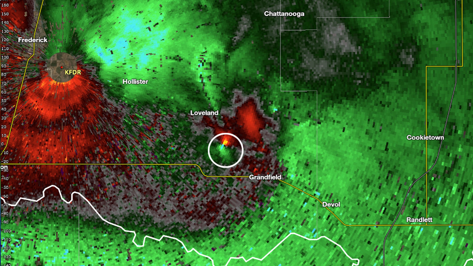
Oklahoma Tornado Did Something That 99% Don't Do
A tornado in Oklahoma Tuesday evening didn't spin in the normal direction we see in the Northern Hemisphere. It was in the rare 1% of tornadoes that spin the opposite direction.
Oklahoma Tornado Did Something That 99% Don't Do
Child's 'Monster' Turns Out To Be Homeowner's Nightmare
A toddler's innocent claim of “monsters” in her bedroom unraveled a chilling discovery in a family’s century-old farmhouse.
Child's 'Monster' Turns Out To Be Homeowner's Nightmare
Tourists Can Visit The House From ‘Up’ This Summer
Tourists can visit the house from “Up” this summer as part of Airbnb’s new “Icons” series. A crane lifts the home into the air.
Tourists Can Visit The House From ‘Up’ This Summer
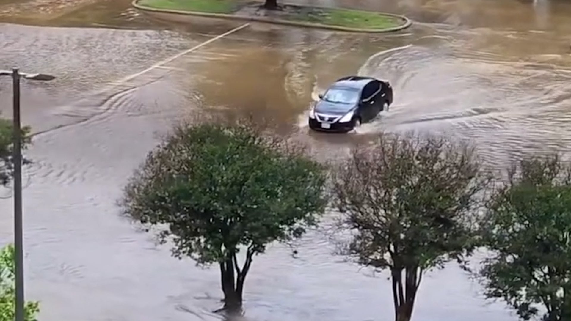
Driver Takes On Texas Flood And Loses
A driver in College Station, Texas, took her chances against rising floodwaters, which she didn’t realize were hiding something more dangerous.
Driver Takes On Texas Flood And Loses
Punxsutawney Phil Needs Help Naming His New Heirs
Punxsutawney Phil and Phyllis need help naming their new baby groundhogs. Can you predict a winner?
Punxsutawney Phil Needs Help Naming His New Heirs
Please enable JavaScript to continue using this application.