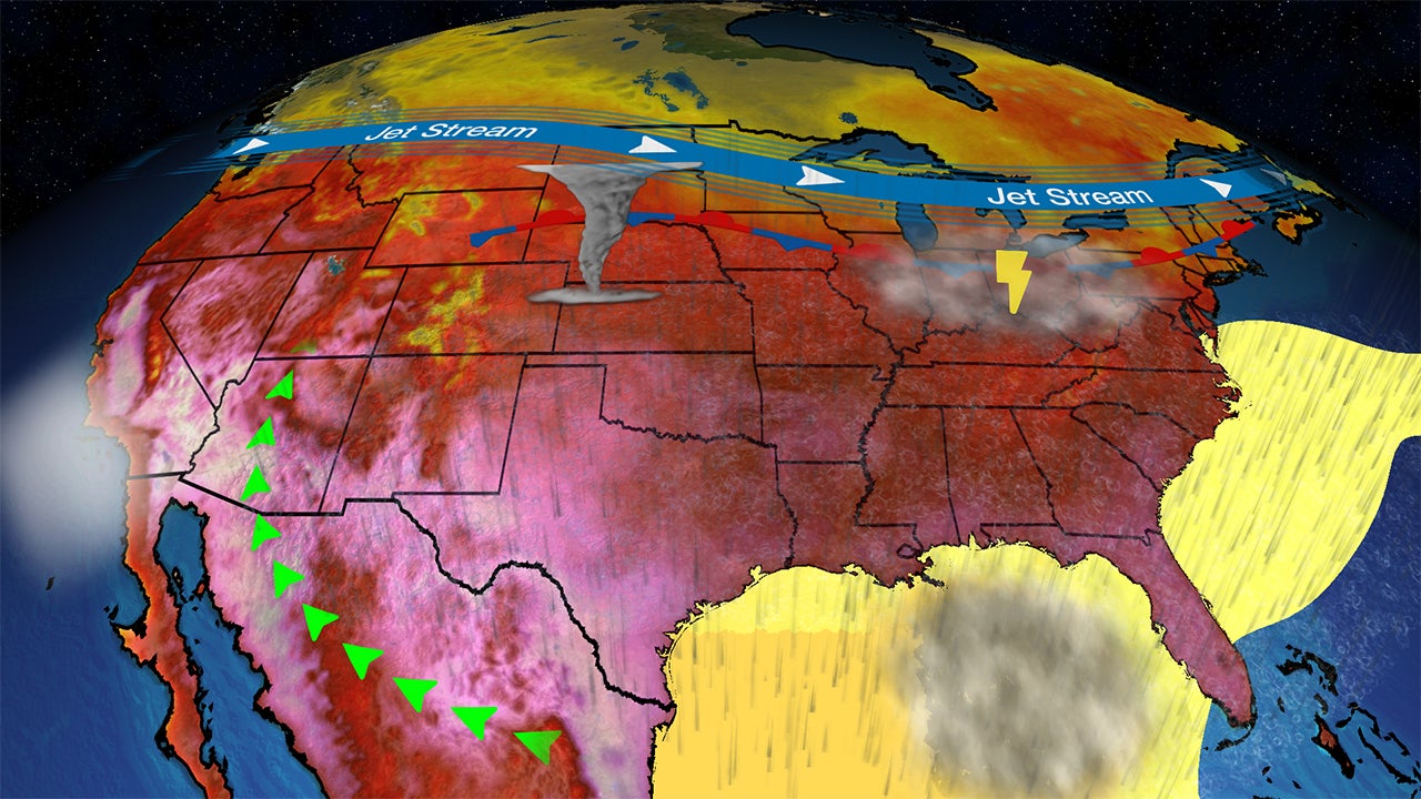
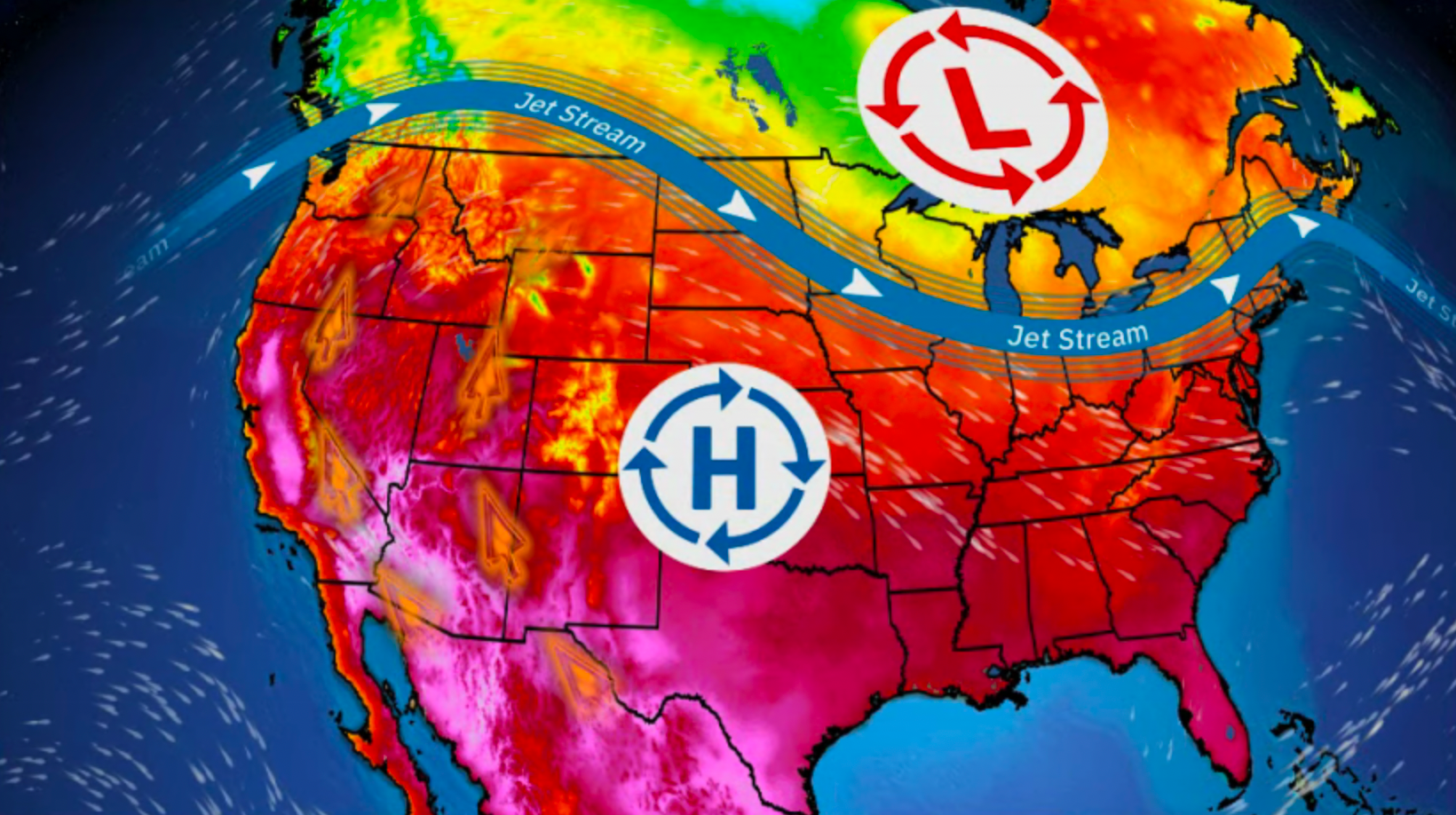
Barkley Regional, KY

2:31 AM CDT on June 18, 2013 (GMT -0500)
Elev: 410 ft
Lon: 88.8° W
Lat: 37.1° N
Source
Rapid Fire Updates™
Updated 1:53 AM CDT Get Free Weather Stickers® Share:
Your Custom Weather Sticker®

Copy the following lines of HTML:
Tropical Weather: Tropical Depression Two (North Atlantic) Tropical Storm Leepi (Western Pacific)
News
June 17, 2013
NASA has eight new astronauts.
June 17, 2013
Heavy rain makes for a nightmare commute in St. Louis, Missori.
June 17, 2013
A collection of NASA Satellite images of the month, from May 2013.
June 17, 2013
See some of the cities threatened the most by climate change and how they'll remedy the rising seas.
June 17, 2013
Deadly flooding continues in India, washing away roads and buildings.
June 17, 2013
It'll take more than a month to get a magnet this large from New York to Chicago.
June 17, 2013
Investigators want to know exactly where the Black Forest Fire started.
June 16, 2013
Heavy weekend rains have caused severe flooding in the Mexican city of Piedras Negras on the border with Texas. Coahuila state officials say one person died and 10,000 houses are damaged, leaving 40,000 peoples homeless.
June 17, 2013
Humans have dreamed of taking control of the weather long before Superman and James Bond villians plotted world domination. Here's a look at some of the colorful ideas behind weather manipulation.
June 17, 2013
Periods of rain Sunday and Monday have helped firefighters get a handle on the Black Forest Fire out of Colorado Springs.
June 16, 2013
Remnants of Oil Spill Linger Despite End of Cleanup
June 16, 2013
Fracking is increasing competition for water, driving up the price of the precious resource and burdening already depleted aquifers and rivers in certain drought-stricken stretches.
June 16, 2013
A pair of earthquakes rattled Latin America over the weekend.
June 16, 2013
Strong showers and thunderstorms developed ahead of a stationary front as it moved through the Great Plains on Saturday.
June 16, 2013
One Texas town recorded more than 16" of rain in 36 hours!
June 14, 2013
Chicago-based photographer Tom Gill battles perilous freezing conditions on Lake Michigan to capture the unique and stunning images of ice-covered lighthouses.
June 14, 2013
For all the recent tornadoes in the nation's heartland and east, we had one Thursday in Oregon. How unusual is that?
June 14, 2013
Emergency response crews are being credited for rescuing a girl and two women from an SUV in northern Iowa that was submerged in rushing floodwater.
June 17, 2013
The Black Forest Fire is now the most destructive fire in Colorado state history.
June 14, 2013
This is probably the most unique eclipse image ever released by NASA, but it's not all it seems.
Weather Summary
Weather Underground Forecast for Tuesday, June 18, 2013.

Wet and unsettled weather continues for parts of the East and South on Tuesday as a cold front dropping southeastward across the Midwest reinforces another frontal boundary extending from the Northeast through the Central Plains. Expect rain and thunderstorm activity along and ahead the advancing cold front in parts of the Ohio Valley into New England, while a cooler airmass behind this cold front leads to cooler daytimes highs in the Upper Great Lakes and Northeast. Areas of isolated to scattered showers and isolated thunderstorms are expected to develop south of the main frontal disturbance from the Mid-Atlantic and Southeast through the Central and Southern Plains. Impulses from from the West will enhance precipitation eastern Oklahoma and northeastern Texas, as well as create the potential for strong to severe thunderstorms in parts of the Central and Southern High Plains. The Storm Prediction Center issued a slight risk of severe thunderstorm development from the late afternoon through the evening. While the main concerns with these storms are isolated areas of hail and damaging wind gusts, a localized tornado threat remains possible.

Meanwhile, thunderstorm will pick up across the High Plains late Monday afternoon. The Storm Prediction Center has issued a slight risk of severe thunderstorm development for parts of the region. While the main concerns with these storms are hail and damaging wind gusts, conditions may turn favorable for isolated tornadoes by the evening.

Out West, an upper level low located off the Pacific Northwest coast will bring progressively better chances for showers to the region through the mid-week. The low will slowly work its way closer to the coast Tuesday, before moving inland Wednesday.

Barkley Regional Weather at a Glance

Updated 1:53 AM CDT
Weather Station
Elevation
410 ft
Report Station
You are about to report this weather station for bad data.

Please select the information which is incorrect and click 'Submit' otherwise click 'Cancel'.

Cancel

Now
Clear
Clear
Temperature
66 °F
Feels Like 66 °F
Wind(mph)
9
Sunrise / Set
5:35 AM
8:17 PM
Moon
Waxing Gibbous
Tonight
Thunderstorm 66 °F
T-storms
70% chance of precipitation
Tuesday
Chance of a Thunderstorm 86 °F
Chance of a Thunderstorm
20% chance of precipitation
Tuesday Night
Partly Cloudy 64 °F
Partly Cloudy
Wednesday
Partly Cloudy 86 | 64 °F
Partly Cloudy
Thursday
Partly Cloudy 88 | 68 °F
Partly Cloudy
Friday
Partly Cloudy 90 | 70 °F
Partly Cloudy
Today is forecast to be nearly the same temperature as yesterday.
Conditions
Pressure
29.85 in
Visibility
10.0 miles
Clouds
Clear -
Moisture
Humidity
93%
Rainfall
0.01 in
Snow Depth
Not available.
METAR
METAR KPAH 180653Z AUTO 06008G16KT 10SM CLR 19/18 A2986 RMK AO2 SLP108 T01890178 $
Don't speak METAR? Read our FAQ.
Weather Radio
Temperature
Temperature
66 °F
72,71,72,71,70,70,70,69,68,67,67,66,67
Dew Point
64 °F
Wind
Speed / Dir
9 mph from ENE
Wind Gust
18 mph
Health
0 out of 16
Pollen
3.30 out of 12
Pollen Forecast
Air Quality
Not available.
Flu Activity
No Activity
View Flu Map
Loading…
Source: BestForecast
Descriptive Forecast
Tuesday
partlycloudy Partly cloudy with a chance of a thunderstorm and a chance of rain. High of 86F. Winds from the North at 5 to 10 mph. Chance of rain 20%.
Tuesday Night
nt_partlycloudy Partly cloudy. Low of 64F. Winds less than 5 mph.
Wednesday
partlycloudy Partly cloudy. High of 86F. Winds less than 5 mph.
Wednesday Night
nt_partlycloudy Partly cloudy. Low of 64F. Winds from the East at 5 to 10 mph.
Thursday
partlycloudy Partly cloudy. High of 88F. Winds from the ESE at 5 to 10 mph.
Thursday Night
nt_mostlycloudy Partly cloudy in the evening, then overcast. Low of 68F. Winds from the ESE at 5 to 10 mph.
Friday
partlycloudy Overcast in the morning, then partly cloudy. High of 90F. Winds less than 5 mph.
Friday Night
nt_partlycloudy Partly cloudy. Low of 70F. Winds from the South at 5 to 10 mph.
Saturday
partlycloudy Partly cloudy in the morning, then clear. High of 90F. Winds from the South at 5 to 10 mph.
Saturday Night
nt_clear Clear. Low of 73F. Winds from the South at 5 to 10 mph.
Sunday
clear Clear. High of 90F. Winds from the South at 5 to 10 mph.
Sunday Night
nt_clear Clear. Low of 73F. Winds from the South at 5 to 10 mph.
Monday
chancetstorms Clear with a chance of a thunderstorm. High of 91F. Winds from the SSW at 5 to 10 mph. Chance of rain 40%.
Monday Night
nt_chancetstorms Partly cloudy with a chance of a thunderstorm. Low of 70F. Winds from the SSW at 5 to 10 mph. Chance of rain 30% with rainfall amounts near 0.2 in. possible.
Tuesday
chancetstorms Partly cloudy with a chance of a thunderstorm. High of 88F. Winds from the SSW at 5 to 10 mph. Chance of rain 30%.
Tuesday Night
nt_partlycloudy Partly cloudy. Fog overnight. Low of 72F. Winds from the SSW at 5 to 15 mph.
Wednesday
chancetstorms Clear with a chance of a thunderstorm. High of 90F. Winds from the SSW at 5 to 10 mph. Chance of rain 40%.
Wednesday Night
nt_clear Clear. Low of 70F. Winds from the SSW at 5 to 10 mph.
Thursday
clear Clear. High of 90F. Winds from the SSW at 5 to 10 mph.
Thursday Night
nt_clear Clear. Low of 73F. Winds from the SSW at 5 to 10 mph.
Friday
clear Clear. High of 90F. Winds from the SSW at 5 to 10 mph.
Friday Night
nt_partlycloudy Clear. Low of 73F. Winds from the SSW at 5 to 10 mph.
Loading…
 
First Previous Last Next  
Updated:  


Barkley Regional Weather Forecast

View Calendar 10-Day Forecast for Barkley Regional Weather Station KPAH

Tuesday, 18
Chance of a Thunderstorm
86 | 64 °F
Chance of a Thunderstorm
Chance of
Precipitation
20%
Wednesday, 19
Partly Cloudy
86 | 64 °F
Partly Cloudy
Chance of
Precipitation
10%
Thursday, 20
Partly Cloudy
88 | 68 °F
Partly Cloudy
Chance of
Precipitation
10%
Friday, 21
Partly Cloudy
90 | 70 °F
Partly Cloudy
Chance of
Precipitation
0%
Saturday, 22
Partly Cloudy
90 | 73 °F
Partly Cloudy
Chance of
Precipitation
0%
Sunday, 23
Clear
90 | 73 °F
Clear
Chance of
Precipitation
0%
Monday, 24
Chance of a Thunderstorm
91 | 70 °F
Chance of T-storms
Chance of
Precipitation
40%
Tuesday, 25
Chance of a Thunderstorm
88 | 72 °F
Chance of T-storms
Chance of
Precipitation
30%
Wednesday, 26
Chance of a Thunderstorm
90 | 70 °F
Chance of T-storms
Chance of
Precipitation
40%
Thursday, 27
Clear
90 | 73 °F
Clear
Chance of
Precipitation
0%
Source: BestForecast at 2:21 AM CDT on June 18, 2013
Descriptive Forecast
Tuesday
partlycloudy Partly cloudy with a chance of a thunderstorm and a chance of rain. High of 86F. Winds from the North at 5 to 10 mph. Chance of rain 20%.
Tuesday Night
nt_partlycloudy Partly cloudy. Low of 64F. Winds less than 5 mph.
Hourly Forecast 6AM 12 Noon 6PM 12 Midnight
Temp. | Dew Point 69 | 64 81 | 64 83 | 63 71 | 64
Wind 6 mph NNE 7 mph NNE 5 mph North 3 mph NNE
Humidity 88% 57% 49% 77%
Chance of Precip. 70% 30% 20% 10%
Cloud Cover 84% 47% 31% 31%
Conditions Rain Showers Chance of a Thunderstorm Chance of a Thunderstorm Partly Cloudy
Sunrise & Sunset
5:35 AM
8:17 PM
The quality of the forecasted high temperature for this day is good. MaxT RMSE [1.74], Average RMSE [1.41]
The National Weather Service forecast quality is good. MaxT RMSE [1.52], Average RMSE [1.36] : Use NWS
Source: BestForecast at 2:21 AM CDT on June 18, 2013
Descriptive Forecast
Wednesday
partlycloudy Partly cloudy. High of 86F. Winds less than 5 mph.
Wednesday Night
nt_partlycloudy Partly cloudy. Low of 64F. Winds from the East at 5 to 10 mph.
Hourly Forecast 6AM 12 Noon 6PM 12 Midnight
Temp. | Dew Point 69 | 64 80 | 62 83 | 62 71 | 63
Wind 3 mph NNE 3 mph NE 5 mph NE 6 mph East
Humidity 89% 52% 47% 75%
Chance of Precip. 10% 10% 10% 10%
Cloud Cover 33% 37% 25% 31%
Conditions Partly Cloudy Partly Cloudy Clear Partly Cloudy
Sunrise & Sunset
5:35 AM
8:17 PM
The quality of the forecasted high temperature for this day is good. MaxT RMSE [1.98], Average RMSE [1.46]
The National Weather Service forecast quality is good. MaxT RMSE [1.85], Average RMSE [1.60] : Use NWS
Source: BestForecast at 2:21 AM CDT on June 18, 2013
Descriptive Forecast
Thursday
partlycloudy Partly cloudy. High of 88F. Winds from the ESE at 5 to 10 mph.
Thursday Night
nt_mostlycloudy Partly cloudy in the evening, then overcast. Low of 68F. Winds from the ESE at 5 to 10 mph.
Hourly Forecast 6AM 12 Noon 6PM 12 Midnight
Temp. | Dew Point 69 | 63 83 | 62 85 | 64 74 | 62
Wind 6 mph East 7 mph ESE 7 mph SE 6 mph ESE
Humidity 83% 48% 48% 66%
Chance of Precip. 0% 10% 10% 0%
Cloud Cover 35% 44% 19% 59%
Conditions Partly Cloudy Partly Cloudy Clear Partly Cloudy
Sunrise & Sunset
5:35 AM
8:18 PM
The quality of the forecasted high temperature for this day is good. MaxT RMSE [2.20], Average RMSE [1.97]
The National Weather Service forecast quality is good. MaxT RMSE [2.25], Average RMSE [1.76] : Use NWS
Source: BestForecast at 2:21 AM CDT on June 18, 2013
Descriptive Forecast
Friday
partlycloudy Overcast in the morning, then partly cloudy. High of 90F. Winds less than 5 mph.
Friday Night
nt_partlycloudy Partly cloudy. Low of 70F. Winds from the South at 5 to 10 mph.
Hourly Forecast 6AM 12 Noon 6PM 12 Midnight
Temp. | Dew Point 71 | 62 85 | 65 86 | 69 76 | 66
Wind 5 mph SE 5 mph SSE 4 mph SSW 5 mph SSW
Humidity 71% 52% 58% 73%
Chance of Precip. 0% 0% 0% 0%
Cloud Cover 96% 43% 3% 31%
Conditions Overcast Partly Cloudy Clear Partly Cloudy
Sunrise & Sunset
5:35 AM
8:18 PM
The quality of the forecasted high temperature for this day is fair. MaxT RMSE [2.65], Average RMSE [2.57]
The National Weather Service forecast quality is fair. MaxT RMSE [2.78], Average RMSE [1.91] : Use NWS
Source: BestForecast at 2:21 AM CDT on June 18, 2013
Descriptive Forecast
Saturday
partlycloudy Partly cloudy in the morning, then clear. High of 90F. Winds from the South at 5 to 10 mph.
Saturday Night
nt_clear Clear. Low of 73F. Winds from the South at 5 to 10 mph.
Hourly Forecast 6AM 12 Noon 6PM 12 Midnight
Temp. | Dew Point 73 | 66 86 | 68 87 | 70 76 | 68
Wind 6 mph SSE 7 mph SSW 6 mph South 5 mph SSW
Humidity 78% 55% 58% 74%
Chance of Precip. 0% 0% 0% 0%
Cloud Cover 63% 15% 23% 16%
Conditions Partly Cloudy Clear Clear Clear
Sunrise & Sunset
5:35 AM
8:18 PM
The quality of the forecasted high temperature for this day is fair. MaxT RMSE [3.26], Average RMSE [3.10]
The National Weather Service forecast quality is fair. MaxT RMSE [2.72], Average RMSE [2.21] : Use NWS
Source: BestForecast at 2:21 AM CDT on June 18, 2013
Descriptive Forecast
Sunday
clear Clear. High of 90F. Winds from the South at 5 to 10 mph.
Sunday Night
nt_clear Clear. Low of 73F. Winds from the South at 5 to 10 mph.
Hourly Forecast 6AM 12 Noon 6PM 12 Midnight
Temp. | Dew Point 76 | 66 87 | 65 88 | 69 77 | 70
Wind 6 mph SSE 6 mph South 7 mph SSE 6 mph South
Humidity 70% 50% 54% 79%
Chance of Precip. 0% 0% 0% 0%
Cloud Cover 13% 5% 29% 2%
Conditions Clear Clear Partly Cloudy Clear
Sunrise & Sunset
5:36 AM
8:18 PM
The quality of the forecasted high temperature for this day is good. MaxT RMSE [2.45], Average RMSE [2.58]
The National Weather Service forecast quality is fair. MaxT RMSE [2.58], Average RMSE [2.30] : Use NWS
Source: BestForecast at 2:21 AM CDT on June 18, 2013
Descriptive Forecast
Monday
chancetstorms Clear with a chance of a thunderstorm. High of 91F. Winds from the SSW at 5 to 10 mph. Chance of rain 40%.
Monday Night
nt_chancetstorms Partly cloudy with a chance of a thunderstorm. Low of 70F. Winds from the SSW at 5 to 10 mph. Chance of rain 30% with rainfall amounts near 0.2 in. possible.
Hourly Forecast 6AM 12 Noon 6PM 12 Midnight
Temp. | Dew Point 74 | 70 87 | 69 85 | 73 76 | 71
Wind 5 mph South 8 mph SSW 7 mph SSW 6 mph SSW
Humidity 84% 58% 66% 81%
Chance of Precip. 0% 20% 20% 10%
Cloud Cover 5% 38% 13% 5%
Conditions Clear Chance of a Thunderstorm Chance of a Thunderstorm Clear
Sunrise & Sunset
5:36 AM
8:18 PM
The quality of the forecasted high temperature for this day is fair. MaxT RMSE [2.93], Average RMSE [2.70]
The National Weather Service forecast quality is fair. MaxT RMSE [2.85], Average RMSE [2.73] : Use NWS
Source: BestForecast at 2:21 AM CDT on June 18, 2013
Descriptive Forecast
Tuesday
chancetstorms Partly cloudy with a chance of a thunderstorm. High of 88F. Winds from the SSW at 5 to 10 mph. Chance of rain 30%.
Tuesday Night
nt_partlycloudy Partly cloudy. Fog overnight. Low of 72F. Winds from the SSW at 5 to 15 mph.
Hourly Forecast 6AM 12 Noon 6PM 12 Midnight
Temp. | Dew Point 72 | 69 85 | 71 85 | 72 76 | 73
Wind 6 mph SSW 9 mph SSW 8 mph SSW 9 mph SSW
Humidity 92% 59% 64% 92%
Chance of Precip. 20% 10% 10% 0%
Cloud Cover 40% 57% 55% 38%
Conditions Chance of a Thunderstorm Partly Cloudy Partly Cloudy Partly Cloudy
Sunrise & Sunset
5:36 AM
8:18 PM
The quality of the forecasted high temperature for this day is poor. MaxT RMSE [3.55], Average RMSE [3.85]
Source: BestForecast at 2:21 AM CDT on June 18, 2013
Descriptive Forecast
Wednesday
chancetstorms Clear with a chance of a thunderstorm. High of 90F. Winds from the SSW at 5 to 10 mph. Chance of rain 40%.
Wednesday Night
nt_clear Clear. Low of 70F. Winds from the SSW at 5 to 10 mph.
Hourly Forecast 6AM 12 Noon 6PM 12 Midnight
Temp. | Dew Point 72 | 72 85 | 72 83 | 73 75 | 72
Wind 8 mph SSW 10 mph SSW 9 mph SSW 9 mph SSW
Humidity 98% 65% 69% 88%
Chance of Precip. 0% 10% 10% 10%
Cloud Cover 38% 27% 6% 4%
Conditions Fog Partly Cloudy Clear Clear
Sunrise & Sunset
5:37 AM
8:18 PM
The quality of the forecasted high temperature for this day is poor. MaxT RMSE [3.82], Average RMSE [4.06]
Source: BestForecast at 2:21 AM CDT on June 18, 2013
Descriptive Forecast
Thursday
clear Clear. High of 90F. Winds from the SSW at 5 to 10 mph.
Thursday Night
nt_clear Clear. Low of 73F. Winds from the SSW at 5 to 10 mph.
Hourly Forecast 6AM 12 Noon 6PM 12 Midnight
Temp. | Dew Point 75 | 71 87 | 73 83 | 74 75 | 73
Wind 7 mph SSW 9 mph SSW 9 mph SSW 7 mph SSW
Humidity 86% 60% 72% 92%
Chance of Precip. 0% 0% 0% 0%
Cloud Cover 18% 11% 14% 15%
Conditions Clear Clear Clear Clear
Sunrise & Sunset
5:37 AM
8:18 PM
Source: BestForecast at 2:21 AM CDT on June 18, 2013
Descriptive Forecast
Friday
clear Clear. High of 90F. Winds from the SSW at 5 to 10 mph.
Friday Night
nt_partlycloudy Clear. Low of 73F. Winds from the SSW at 5 to 10 mph.
Hourly Forecast 6AM 12 Noon 6PM 12 Midnight
Temp. | Dew Point 75 | 72 87 | 73 83 | 75 75 | 74
Wind 6 mph SSW 8 mph SSW 7 mph SSW 7 mph SSW
Humidity 88% 63% 74% 96%
Chance of Precip. 0% 0% 0% 0%
Cloud Cover 14% 14% 14% %
Conditions Clear Clear Clear Clear
Sunrise & Sunset
Sun does not rise
Nearby
Weather History & Almanac
June 18, 2013 Max Temp Min Temp
Normal 87 °F 66 °F
Record 99 °F (1944) 49 °F (1960)
Yesterday 88 °F 67 °F
Yesterday's Cooling Degree Days: 13
Choose a date
Earthquake Activity
City Distance Mag. Time & Date
No recent earthquake activity has been reported nearby.
Minimum magnitude displayed is 2.5.
Astronomy
Jun. 18, 2013 Rise Set
Actual Time 5:35 AM CDT 8:17 PM CDT
Civil Twilight 5:04 AM CDT 8:48 PM CDT
Nautical Twilight 4:25 AM CDT 9:27 PM CDT
Astronomical Twilight 3:42 AM CDT 10:10 PM CDT
Moon 3:07 PM CDT 1:37 AM CDT
Length Of Visible Light 15h 44m
Length of Day
14h 42m
Tomorrow will be 0m 6s longer.
Waxing Gibbous, 67% of the Moon is Illuminated
Today
Waxing Gibbous
Jun 23
Full
Jun 29
Last Quarter
Jul 8
New
Jul 15
First Quarter
Today's Extremes
State Highs State Lows
71 °F
Harlan
71 °F
Middlesboro
70 °F
Covington
69 °F
London-Corbin
69 °F
Bowling Green
62 °F
Jackson
64 °F
Owensboro
64 °F
Murray
64 °F
Harlan
64 °F
Richmond
Snow Depth
Station Depth Elevation
No new snow has been reported.
WunderPhotos®
sweet little sunset
Just after sundown
Uploaded by: jjulian
1,621,444 photos uploaded!
WunderBlogs®

There are no recent blogs in this area. Why not create your own?

Travel & Activities
Travel Planning
Destination? *
When are you going?
to
Is there an activity you would like to explore?
* Required field
Aviation
City Temp. Conditions Updated
Paducah 66 °F Clear 1:53 AM CDT
Metropolis 67 °F Mostly Cloudy 2:15 AM CDT
Cairo 70 °F Overcast 2:15 AM CDT
Murray 66 °F Overcast 2:15 AM CDT
Flight To ETA Status
No flights were found.
Flight Tracker by FlightAware FlightAware
Type Condition
Flight Rule: VFR (KPAH)
Wind Speed: 8.0 kts.
Wind Dir: 60° (ENE)
Ceiling: Unlimited

METAR KPAH 180653Z AUTO 06008G16KT 10SM CLR 19/18 A2986 RMK AO2 SLP108 T01890178 $

Nearby Events
Event Date Forecast
No events within 10 mi of location. View all events.
Event data courtesy eviesays.com
Sports
Event Date Forecast
Marlins vs. Diamondbacks 6:40 PM MST on June 17, 2013 Clear, 101 °F
Mariners vs. Angels 7:05 PM PDT on June 17, 2013 Clear, 67 °F
Event Date Forecast
Almería vs. Girona 8:00 PM CEST on June 19, 2013 Chance of Rain, High 78° F/ 26° C
Houston vs. Montreal 8:00 PM EDT on June 19, 2013 Forecast not available.
Event Date Forecast
Toyota/Save Mart 350 12:19 PM PDT on June 23, 2013 Clear, 70 °F
Quaker State 400 7:45 PM EDT on June 29, 2013 Average High 84° F/ 28° C
Event Date Forecast
Travelers Championship 8:30 AM EDT on June 20, 2013 Clear, 56 °F
Travelers Championship 8:30 AM EDT on June 21, 2013 Clear, 61 °F
Videos
Year In Weather 2012

Watch the nearly year-long satellite animation as Weather Underground calls out the most significant weather events of the past year, including Superstorm Sandy and Hurricane Isaac.

Barkley Regional Weather Stations
Station Location Temp. Dew Point Humidity Wind Precipitation Elevation Updated Type Website
Heath, West Paducah, KY 65.8 °F 55 °F 69% NW  at  9.8 mph 0.01 in / hr 404 ft 2:31 AM CDT Rapid Fire
Kevil Ky, Kevil, KY 66.5 °F 65 °F 94% East  at  2.0 mph 0.00 in / hr 0 ft 2:31 AM CDT Rapid Fire  
Metropolis, Metropolis, IL 65.5 °F 63 °F 93% North  at  0.0 mph 0.00 in / hr 359 ft 2:31 AM CDT Rapid Fire
Metropolis, IL 67.3 °F 66 °F 94% ESE  at  0.0 mph 0.00 in / hr 0 ft 2:31 AM CDT Rapid Fire  
Gage Area, La Center, KY 66.7 °F 66 °F 97% WNW  at  6.9 mph 0.00 in / hr 456 ft 2:31 AM CDT Rapid Fire
Paducah Ky, Paducah, KY 63.9 °F 62 °F 93% NNW  at  1.0 mph 0.00 in / hr 0 ft 2:31 AM CDT Rapid Fire  
Weather Observatory, Round Knob, IL 67.0 °F 67 °F 99% NW  at  4.0 mph 0.00 in / hr 550 ft 2:31 AM CDT Rapid Fire
South Adkins Dixon Road, Wickliffe, KY 65.8 °F 65 °F 97% NW  at  1.1 mph 0.00 in / hr 443 ft 2:31 AM CDT Rapid Fire
Reidland, Paducah, KY 69.2 °F 69 °F 100% SSE  at  0.0 mph - / hr 330 ft 2:31 AM CDT Normal  
hopewell rd, Boaz, KY 65.2 °F 64 °F 96% NE  at  1.0 mph 0.00 in / hr 400 ft 2:29 AM CDT Normal
Hickory, Ky, Hickory, KY 66.7 °F 65 °F 95% East  at  7.0 mph - / hr 427 ft 2:18 AM CDT Normal
KYTC_RWIS US-51 @ Willow Slough Br. (Wic, Wickliffe, KY 67 °F - - NNW  at  8 mph 0.00 in / hr 320 ft 2:10 AM CDT MADIS
Would you like to share your weather data with the rest of the world? Add Your Weather Station!
Local Storm Report


06/17/2013 0311 PM

Paducah, McCracken County.

Flood, reported by public.


            Houser Rd near old Mayfield Rd impassable.


06/17/2013 0245 PM

Paducah, McCracken County.

Heavy rain m3.05 inch, reported by trained spotter.


            3.05 inches of rain in 45 min


06/17/2013 0229 PM

Paducah, McCracken County.

Thunderstorm wind damage, reported by law enforcement.


            Tree down over Benton Road in Reidland near Railroad
            tracks. Another tree down across New Hope Church Road.