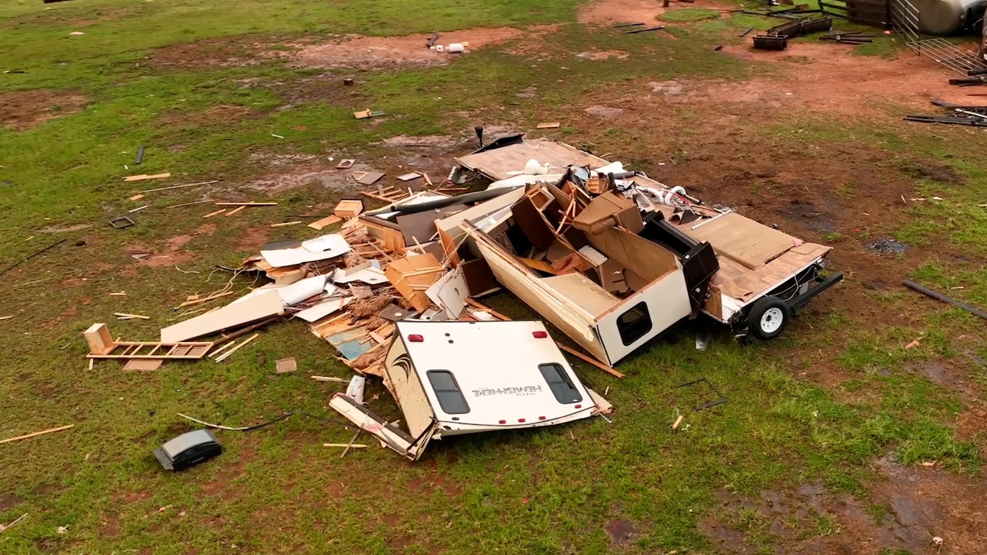
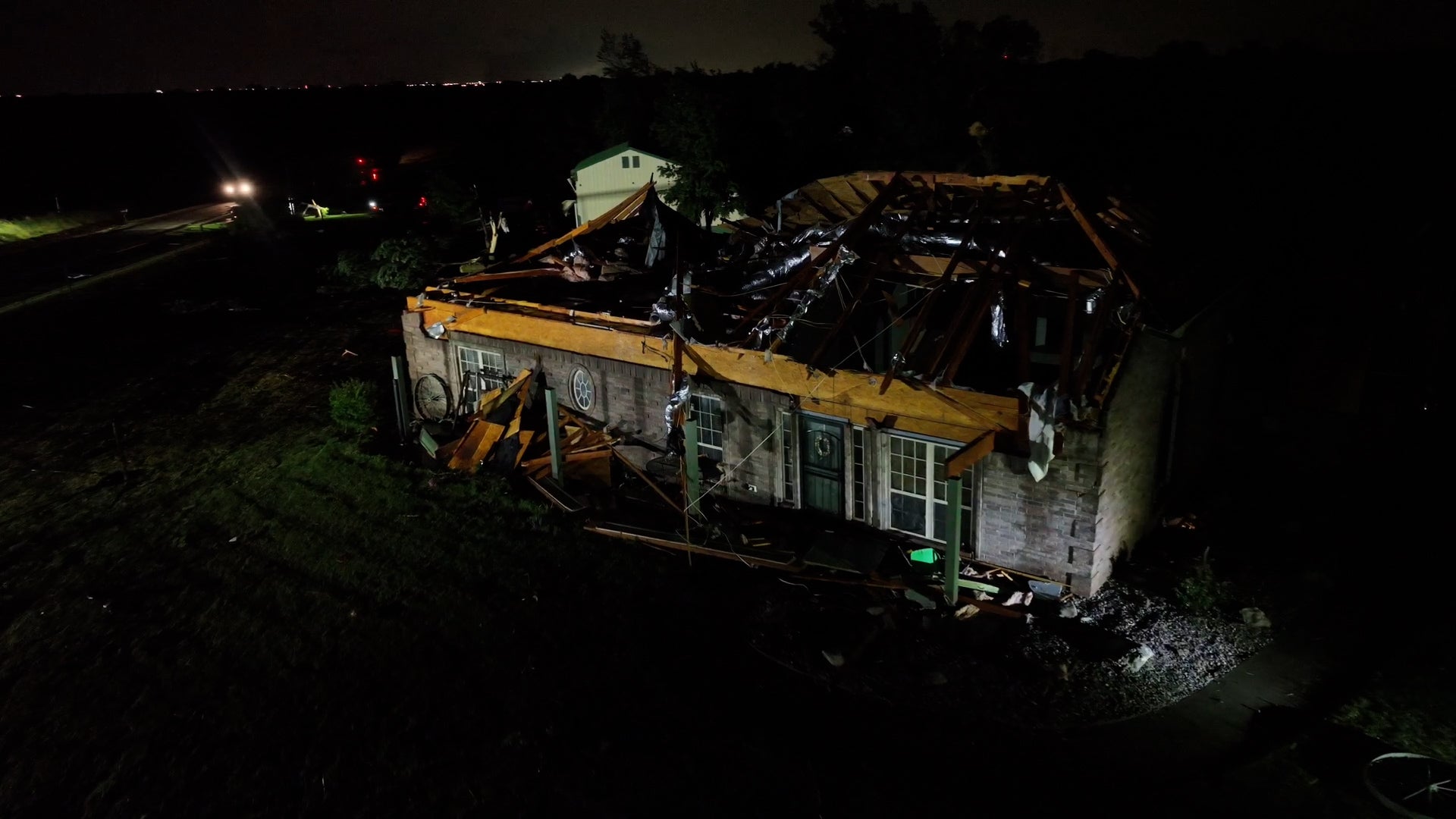
Bowling Green-Warren County Regional, KY

10:31 PM CST on February 10, 2012 (GMT -0600)
Elev: 545 ft
Lon: 86.4° W
Lat: 37.0° N
Rapid Fire Updates™ Updated 9:53 PM CST Make this Location a Weather Sticker® Share:
Your Custom Weather Sticker®

Copy the following lines of HTML:
Tropical Weather: Tropical Cyclone Giovanna (South Indian Ocean) Tropical Cyclone Jasmine (Southern Pacific)
Weather Summary
Weather Underground midday recap for Friday, February 10, 2012.

Snow showers moved through the Midwest, thunderstorms developed in the South, and cold air poured into the Plains on Friday. A trough of low pressure moved eastward from the Southern Plains and continued to push a cold front eastward, which extended from the Great Lakes into the Gulf states. The southern end of this system pulled moisture in from the Gulf of Mexico and triggered scattered showers and thunderstorms over the Lower Mississippi Valley. Severe storms have not been reported over the region, but rainfall totals reached over an inch in eastern Texas and southern Louisiana. Heaviest rainfall was reported at Angleton, Texas with a mid-day total of 1.12 inches of rain.

To the North, cool air over the Great Lakes and Midwest allowed for snow showers to develop along the northern side of this cold front. Snowfall accumulation ranged from 1 to 2 inches from southern Wisconsin and Michigan, through Ohio and the Central Appalachians. Some of these areas saw a messy combination of freezing rain and sleet.

Behind this system, a strong ridge of high pressure built into the Plains. This pushed in cool and dry air from central Canada and brought cold and breezy conditions to most of the Plains. The Northern Plains and Upper Midwest saw highs in the single digits, with overnight lows temperatures near 10 degrees below zero. Parts of the Southern Plains saw highs in the 40s, with overnight lows in the 20s.

Out West, a trough of low pressure pushed another cold front toward the Pacific Northwest. Moisture poured in ahead of this system, kicking up more rain showers over Oregon and Washington, with a few sprinkles in northern California. The Northern Rockies saw light and scattered snow showers as moisture reached over Idaho and Montana. Snowfall accumulations ranged from 2 to 4 inches in these areas.
Bowling Green-Warren County Regional Weather at a Glance
Updated 9:53 PM CST
Weather Station
Elevation
545 ft
Report Station
You are about to report this weather station for bad data.

Please select the information which is incorrect and click 'Submit' otherwise click 'Cancel'.

Cancel

Now
Overcast
Overcast
Temperature
36 °F
Feels Like 30 °F
Wind(mph)
8
Sunrise / Set
6:40 AM
5:20 PM
Moon
Waning Gibbous
Tonight
Snow 23 °F
Snow
90% chance of precipitation
Tomorrow
Partly Cloudy 27 °F
Partly Cloudy
Tomorrow Night
Clear 16 °F
Clear
Sunday
Clear 34 | 20 °F
Clear
Monday
Mostly Cloudy 40 | 32 °F
Mostly Cloudy
Tuesday
Chance of Snow 43 | 32 °F
Chance of Snow
30% chance of precipitation
Tomorrow is forecast to be Much Cooler than today.
Conditions
Pressure
30.03 in
Visibility
4.0 miles
Clouds
Overcast 600 ft
Moisture
Humidity
89%
Rainfall
0.01 in
Snow Depth
Not available.
METAR
METAR KBWG 110353Z AUTO 24007KT 4SM BR OVC006 02/01 A3002 RMK AO2 UPB27E44SNE27 SLP169 P0000 T00220006
Don't speak METAR? Read our FAQ.
Weather Radio
Temperature
Windchill
30 °F
Dew Point
33 °F
Wind
Speed / Dir
8 mph from WSW
Wind Gust
Health
UV
0 out of 16
Pollen
1.70 out of 12
Pollen Forecast
Air Quality
Not available.
Flu Activity
Local Activity
View Flu Map
Loading…
Regional Forecast for Warren
Tonight
nt_snow Snow and chance of light sleet. Little or no snow and sleet accumulation. Lows in the mid 20s. Northwest winds 5 to 15 mph with gusts to around 30 mph. Chance of precipitation 90 percent.
Saturday
partlycloudy Partly cloudy. Highs in the upper 20s. Northwest winds 10 to 15 mph with gusts to around 30 mph.
Saturday Night
nt_sunny Mostly clear. Lows around 17. Northwest winds 5 to 10 mph with gusts to around 25 mph.
Sunday
partlycloudy Mostly sunny. Highs in the mid 30s. Northwest winds 5 to 10 mph.
Sunday Night
nt_sunny Mostly clear. Lows around 20. West winds up to 5 mph.
Monday
cloudy Mostly cloudy. Highs in the upper 30s.
Monday Night
nt_snow Rain and snow likely. Lows in the lower 30s. Chance of precipitation 60 percent.
Tuesday
snow Cloudy with a 40 percent chance of rain and light snow. Highs in the lower 40s.
Tuesday Night
nt_partlycloudy Partly cloudy. Lows in the lower 30s.
Wednesday
partlycloudy Partly cloudy with a 20 percent chance of rain. Highs around 50.
Wednesday Night and Thursday
nt_chancerain Mostly cloudy with a 30 percent chance of rain. Lows in the upper 30s. Highs in the lower 50s.
Thursday Night
nt_chancerain Partly cloudy with a 30 percent chance of rain. Lows in the upper 30s.
Friday
partlycloudy Partly cloudy with a 20 percent chance of rain. Highs in the mid 50s.
Source: NWS at 6:20 PM CST on February 10, 2012
Loading…
 
First Previous Last Next  
Updated:  


Nowcast
Winter Weather Advisory in effect until 11 am CST Saturday...
Forecast
View Calendar 7-Day Weather Forecast for 42102
Saturday, 11
Partly Cloudy
27 | 16 °F
Partly Cloudy
Chance of
Precipitation
10%
Sunday, 12
Clear
34 | 20 °F
Clear
Chance of
Precipitation
0%
Monday, 13
Mostly Cloudy
40 | 32 °F
Mostly Cloudy
Chance of
Precipitation
10%
Tuesday, 14
Chance of Snow
43 | 32 °F
Chance of Snow
Chance of
Precipitation
30%
Wednesday, 15
Chance of Rain
50 | 38 °F
Chance of Rain
Chance of
Precipitation
20%
Thursday, 16
Chance of Rain
52 | 38 °F
Chance of Rain
Chance of
Precipitation
30%
Friday, 17
Chance of Rain
56 | NA
Chance of Rain
Chance of
Precipitation
20%
Source: NWS at 6:20 PM CST on February 10, 2012
Regional Forecast for Warren
Saturday
partlycloudy Partly cloudy. Highs in the upper 20s. Northwest winds 10 to 15 mph with gusts to around 30 mph.
Saturday Night
nt_sunny Mostly clear. Lows around 17. Northwest winds 5 to 10 mph with gusts to around 25 mph.
Hourly Forecast 6AM 12 Noon 6PM 12 Midnight
Temp. | Dew Point 23 | 20 27 | 11 22 | 7 20 | 7
Wind 13 mph NW 13 mph NNW 7 mph NW 7 mph NW
Humidity 84% 52% 51% 56%
Chance of Precip. 90% 10% 10% 0%
Cloud Cover 75% 32% 18% 11%
Conditions Mostly Cloudy Partly Cloudy Clear Clear
Sunrise & Sunset
6:40 AM
5:20 PM
Source: NWS at 6:20 PM CST on February 10, 2012
Regional Forecast for Warren
Sunday
partlycloudy Mostly sunny. Highs in the mid 30s. Northwest winds 5 to 10 mph.
Sunday Night
nt_sunny Mostly clear. Lows around 20. West winds up to 5 mph.
Hourly Forecast 6AM 12 Noon 6PM 12 Midnight
Temp. | Dew Point 18 | 7 29 | 7 29 | 11 23 | 11
Wind 6 mph NW 7 mph WNW 5 mph West 1 mph WSW
Humidity 58% 36% 46% 59%
Chance of Precip. 0% 0% 0% 0%
Cloud Cover 11% 8% 10% 23%
Conditions Clear Clear Clear Clear
Sunrise & Sunset
6:39 AM
5:21 PM
Source: NWS at 6:20 PM CST on February 10, 2012
Regional Forecast for Warren
Monday
cloudy Mostly cloudy. Highs in the upper 30s.
Monday Night
nt_snow Rain and snow likely. Lows in the lower 30s. Chance of precipitation 60 percent.
Hourly Forecast 6AM 12 Noon 6PM 12 Midnight
Temp. | Dew Point 22 | 13 36 | 11 36 | 20 34 | 25
Wind 1 mph South 6 mph South 5 mph South 6 mph South
Humidity 65% 37% 49% 69%
Chance of Precip. 0% 10% 10% 60%
Cloud Cover 47% 72% 88% 98%
Conditions Partly Cloudy Mostly Cloudy Rain Snow
Sunrise & Sunset
6:38 AM
5:22 PM
Source: NWS at 6:20 PM CST on February 10, 2012
Regional Forecast for Warren
Tuesday
snow Cloudy with a 40 percent chance of rain and light snow. Highs in the lower 40s.
Tuesday Night
nt_partlycloudy Partly cloudy. Lows in the lower 30s.
Hourly Forecast 6AM 12 Noon 6PM 12 Midnight
Temp. | Dew Point 34 | 29 40 | 36 38 | 36 36 | 34
Wind 5 mph South 6 mph SSW 4 mph SW 2 mph SW
Humidity 84% 81% 88% 92%
Chance of Precip. 60% 40% 40% 10%
Cloud Cover 98% 89% 70% 64%
Conditions Chance of Snow Chance of Rain Mostly Cloudy Partly Cloudy
Sunrise & Sunset
6:37 AM
5:23 PM
Source: NWS at 6:20 PM CST on February 10, 2012
Regional Forecast for Warren
Wednesday
partlycloudy Partly cloudy with a 20 percent chance of rain. Highs around 50.
Wednesday Night and Thursday
nt_chancerain Mostly cloudy with a 30 percent chance of rain. Lows in the upper 30s. Highs in the lower 50s.
Hourly Forecast 6AM 12 Noon 6PM 12 Midnight
Temp. | Dew Point 34 | 31 47 | 38 47 | 38 41 | 36
Wind 1 mph South 4 mph South 4 mph SE 4 mph SSE
Humidity 88% 71% 73% 79%
Chance of Precip. 10% 20% 20% 30%
Cloud Cover 68% 59% 70% 75%
Conditions Chance of Rain Chance of Rain Chance of Rain Chance of Rain
Sunrise & Sunset
6:35 AM
5:24 PM
Source: NWS at 6:20 PM CST on February 10, 2012
Regional Forecast for Warren
Wednesday Night and Thursday
nt_chancerain Mostly cloudy with a 30 percent chance of rain. Lows in the upper 30s. Highs in the lower 50s.
Thursday Night
nt_chancerain Partly cloudy with a 30 percent chance of rain. Lows in the upper 30s.
Hourly Forecast 6AM 12 Noon 6PM 12 Midnight
Temp. | Dew Point 40 | 36 49 | 43 47 | 41 43 | 40
Wind 2 mph SE 4 mph South 1 mph South 1 mph East
Humidity 89% 77% 79% 88%
Chance of Precip. 30% 30% 30% 30%
Cloud Cover 87% 75% 72% 60%
Conditions Chance of Rain Chance of Rain Chance of Rain Chance of Rain
Sunrise & Sunset
6:35 AM
5:24 PM
Source: NWS at 6:20 PM CST on February 10, 2012
Regional Forecast for Warren
Friday
partlycloudy Partly cloudy with a 20 percent chance of rain. Highs in the mid 50s.
Hourly Forecast 6AM 12 Noon 6PM 12 Midnight
Temp. | Dew Point 40 | 36 52 | 41 47 | 41 43 | 40
Wind 2 mph ENE 1 mph West 1 mph South 1 mph East
Humidity 81% 68% 79% 88%
Chance of Precip. 30% 20% 30% 30%
Cloud Cover 57% 67% 72% 60%
Conditions Chance of Rain Chance of Rain Chance of Rain Chance of Rain
Sunrise & Sunset
6:35 AM
5:24 PM
BestForecast (what's this?)
Nearby
History & Almanac
February 10, 2012 Max Temp Min Temp
Normal 49 °F 29 °F
Record 79 °F (1932) -16 °F (1899)
Yesterday 43 °F 30 °F
Yesterday's Heating Degree Days: 28
Choose a date
Earthquake Activity
City Distance Mag. Time & Date
No recent earthquake activity has been reported nearby.
Minimum magnitude displayed is 2.5.
Astronomy
Feb. 10, 2012 Rise Set
Actual Time 6:40 AM CST 5:20 PM CST
Civil Twilight 6:13 AM CST 5:46 PM CST
Nautical Twilight 5:42 AM CST 6:17 PM CST
Astronomical Twilight 5:12 AM CST 6:47 PM CST
Moon 8:50 PM CST (2/10) 7:54 AM CST (2/10)
Length Of Visible Light 11h 33m
Length of Day
10h 39m
Tomorrow will be 2m 6s longer.
Waning Gibbous, 86% of the Moon is Illuminated
Today
Waning Gibbous
Feb 14
Last Quarter
Feb 21
New
Feb 29
First Quarter
Mar 8
Full
Today's Extremes
State Highs State Lows
42 °F
Middlesboro
40 °F
Bowling Green
39 °F
Fort Campbell
39 °F
Henderson
38 °F
London-Corbin
23 °F
Monticello
26 °F
London-Corbin
26 °F
Danville
26 °F
Harlan
26 °F
Middlesboro
Source: NWS
Snow Depth
Station Depth Elevation
No new snow has been reported.
WunderPhotos®
cyclone Ismet
Crossing Over...
Uploaded by: antoniomise
1,456,355 photos uploaded!
WunderBlogs®

There are no recent blogs in this area. Why not create your own?

Travel & Activities
Travel Planning
Destination? *
When are you going?
to
Is there an activity you would like to explore?
* Required field
Aviation
City Temp. Conditions Updated
Bowling Green 36 °F Overcast 9:53 PM CST
Glasgow 32 °F Light Snow 10:15 PM CST
Nashville 36 °F Light Snow Mist 9:53 PM CST
Clarksville This station is not reporting.
Flight To ETA Status
SWA2065
Chicago, IL
KBNA 10:07PM On Time
TCF5876
New York, NY
KBNA 10:28PM On Time
FFT230
Denver, CO
KBNA 10:30PM On Time
AWE1869
Charlotte, NC
KBNA 10:32PM On Time
Flight Tracker by FlightAware FlightAware
Type Condition
Flight Rule: IFR (KBWG)
Wind Speed: 7.0 kts.
Wind Dir: 240° (WSW)
Ceiling: 600 ft

METAR KBWG 110353Z AUTO 24007KT 4SM BR OVC006 02/01 A3002 RMK AO2 UPB27E44SNE27 SLP169 P0000 T00220006

Nearby Events
Event Date Forecast
Powder Puff Mechanics 10:00 AM CST 2012-02-11 Overcast, 24°F
Josh London Band 10:00 PM CST 2012-02-11 Clear, 23°F
Super Sunday 2012 11:00 AM CST 2012-02-12 Clear, 29°F
Meet Stella & Dot, Bowling Green, KY 11:00 AM CST 2012-02-16 Chance of Rain, 48°F
Event data courtesy eviesays.com
Sports
Event Date Forecast
Budweiser Shootout 8:29 PM EST on February 18, 2012 Average High 71° F/ 21° C
Gatorade Duel 1 2:19 PM EST on February 23, 2012 Average High 70° F/ 21° C
Event Date Forecast
AT&T Pebble Beach National Pro-Am 8:30 AM PST on February 11, 2012 Chance of Rain, 45 °F
AT&T Pebble Beach National Pro-Am 8:30 AM PST on February 12, 2012 Mostly Cloudy, 45 °F
Weather Stations
Station Location Temp. Windchill Dew Point Humidity Wind Precipitation Elevation Updated Type Website
HADS BARREN RIVER AT BOWLING GREEN KY, Bowling Green, KY - - - - North  at  - 0.01 in / hr 480 ft 9:45 PM CST MADIS
Quarry View, Bowling Green, KY 35.0 °F 35 °F 35 °F 100% WNW  at  0.0 mph 0.01 in / hr 584 ft 10:31 PM CST Rapid Fire
Ridgeview Drive, Bowling Green, KY 34.4 °F 34 °F 33 °F 95% SW  at  1.0 mph 0.01 in / hr 714 ft 10:31 PM CST Rapid Fire
HADS BARREN RIVER NEAR FINNEY 2SW KY, Lucas, KY - - - - North  at  - 0.00 in / hr 520 ft 9:00 PM CST MADIS
HADS GREEN RIVER AT BROWNSVILLE KY, Brownsville, KY - - - - North  at  - 0.01 in / hr 560 ft 9:45 PM CST MADIS
RAWS HOUCHIN MEADOW KY, Rocky Hill, KY 33 °F 33 °F 33 °F 99% SW  at  3 mph 0.00 in / hr 773 ft 9:12 PM CST MADIS
MesoWest Franklin 4 SW , Franklin, KY 34 °F 27 °F 33 °F 96% WSW  at  9 mph 0.00 in / hr 740 ft 9:45 PM CST MADIS
HADS NOLIN RIVER LAKE AT KYROCK NEAR KY, Sweeden, KY - - - - North  at  - 0.00 in / hr 609 ft 9:10 PM CST MADIS
Would you like to share your weather data with the rest of the world? Add Your Weather Station!
Winter Weather Advisory
Mobile & Email Alerts Statement as of 8:08 PM CST on February 10, 2012

... Winter Weather Advisory remains in effect until noon EST
/11 am CST/ Saturday...

A Winter Weather Advisory remains in effect until noon EST /11 am
CST/ Saturday.

* Timing: light to moderate snow will continue tonight into
Saturday morning.

* Main impact: snow tonight will result in snowfall accumulations
from a trace to around an inch north of the western Kentucky and
Bluegrass parkways. Further south... across southern Kentucky a
half inch of snow or less is expected.

* Other impacts: the combination of the anticipated snowfall along
with temperatures falling into the 20s tonight may lead to
hazardous driving conditions across the area. If you have travel
plans for tonight... allow yourself plenty of time to reach your
destination.

Precautionary/preparedness actions...

A Winter Weather Advisory for snow means that periods of snow
will cause primarily travel difficulties. Be prepared for slick roads
and limited visibilities... and use caution while driving.

Stay tuned to NOAA all hazards weather radio and your local media
for the latest updates on this winter weather situation.


Public Information Statement
Mobile & Email Alerts Statement as of 07:26 PM EST on February 10, 2012

... Snow reports for Louisville County Warning Area climate sites...

Location snowfall since total snow
                                     midnight on ground
                                     through 7 PM at 7 PM
                                     (inches) (inches)

Lexington (official) T 0
Louisville international (official) T 0
Louisville NWS office T 0
Bowling Green (official) T 0