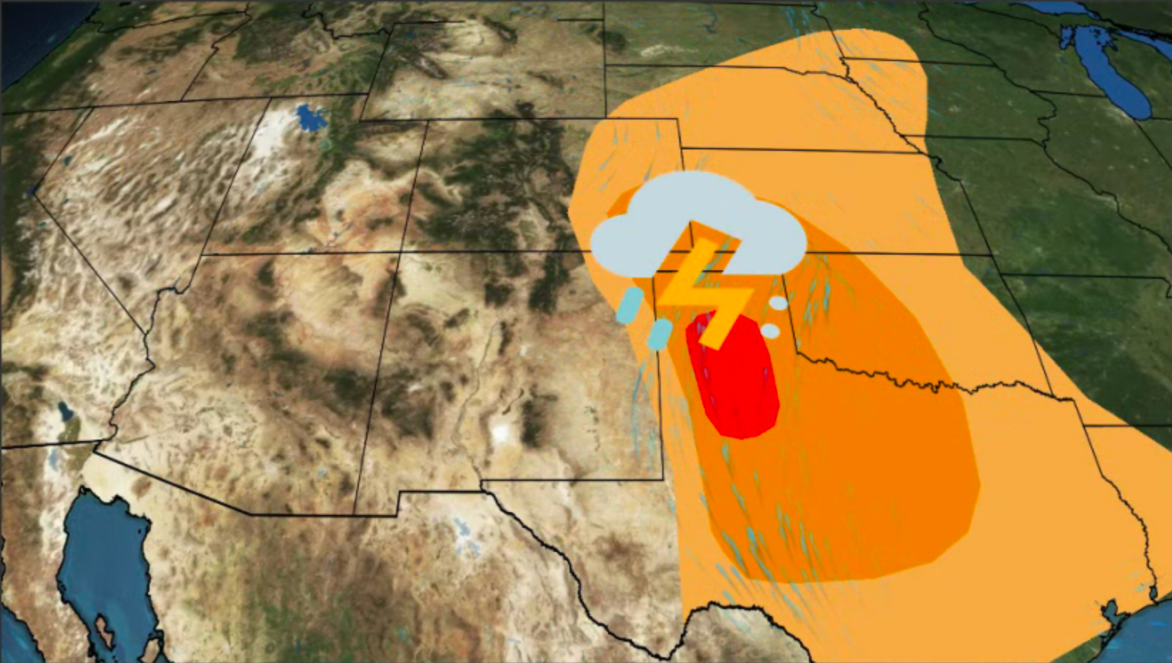
New York, NY

10:36 PM EDT on June 18, 2013 (GMT -0400)
Elev: 92 ft
Lon: 74.0° W
Lat: 40.8° N
Source
Rapid Fire Updates™
Updated 10:12 PM EDT Get Free Weather Stickers® Share:
Your Custom Weather Sticker®

Copy the following lines of HTML:
Tropical Weather: Tropical Depression Two (North Atlantic) Tropical Storm Leepi (Western Pacific)
News
June 18, 2013
Women who are exposed to high levels of air pollution during pregnancy might be twice as likely to have a child with autism, according to a new study from the Harvard School of Public Health thats published in the journal Environmental Health Perspectives.
June 18, 2013
Get your telescopes ready -- the largest full moon of the year is coming!
June 18, 2013
The World's Most Amazing Places: Fly Geyser
June 18, 2013
With 4 million people in its shadow, a massive volcano in Mexico rumbles back to life.
June 18, 2013
Tropical Depression Two is moving west over Guatemala and Mexico.
June 18, 2013
Check out incredible views of a planet that hasn't been photographed by NASA in nearly 40 years.
June 18, 2013
The weather in London has been far from normal lately, and the locals want to find out why.
June 17, 2013
NASA has eight new astronauts.
June 17, 2013
Heavy rain makes for a nightmare in cities from St. Louis to Cape Girardeau.
June 17, 2013
A collection of NASA Satellite images of the month, from May 2013.
June 17, 2013
See some of the cities threatened the most by climate change and how they'll remedy the rising seas.
June 17, 2013
Deadly flooding continues in India, washing away roads and buildings.
June 17, 2013
It'll take more than a month to get a magnet this large from New York to Chicago.
June 17, 2013
Investigators want to know exactly where the Black Forest Fire started.
June 16, 2013
Heavy weekend rains have caused severe flooding in the Mexican city of Piedras Negras on the border with Texas. Coahuila state officials say one person died and 10,000 houses are damaged, leaving 40,000 peoples homeless.
June 17, 2013
Humans have dreamed of taking control of the weather long before Superman and James Bond villians plotted world domination. Here's a look at some of the colorful ideas behind weather manipulation.
June 18, 2013
Periods of rain have helped firefighters get a handle on the Black Forest Fire out of Colorado Springs.
June 16, 2013
Remnants of Oil Spill Linger Despite End of Cleanup
June 16, 2013
Fracking is increasing competition for water, driving up the price of the precious resource and burdening already depleted aquifers and rivers in certain drought-stricken stretches.
June 16, 2013
A pair of earthquakes rattled Latin America over the weekend.
Weather Summary
Weather Underground midday recap for Tuesday, June 18, 2013.

Wet and unsettled weather continued for parts of the East and South on Tuesday as a cold front dropped southeastward across the Midwest and Northeast and reinforced another frontal boundary extending from southern New England through the Southern Plains. Rain and thunderstorm activity developed ahead the advancing cold front in parts of the Ohio Valley into New England, while a cooler airmass followed behind the cold front and led to cooler daytimes highs in the Upper Great Lakes and Northeast. Areas of scattered showers and thunderstorms developed near and to the south of the main frontal disturbance from the Mid-Atlantic and Southeast through the Central and Southern Plains. The Storm Prediction Center issued a slight risk of severe thunderstorms for parts of the lower Ohio Valley and eastern and central Carolinas through the afternoon and evenings. Areas of the Ohio Valley were at primary risks of damaging wind gusts and hail, while areas of the Carolinas remained at risk of damaging wind gusts.

Meanwhile, behind this activity impulses from from the West enhanced precipitation and thunderstorm activity in the High Plains and created the potential for strong to severe thunderstorms for a large part of the region. The Storm Prediction Center issued a slight risk of severe thunderstorm development from this afternoon through tonight with threats of hail and damaging wind gusts.

Elsewhere, an upper level low located off the Pacific Northwest coast brought progressively better chances for showers and thunderstorm activity to the Northwest. The Storm Prediction Center issued a slight risk of severe thunderstorm development for the Northern Rockies with hail and damaging wind gusts possible from this afternoon through tonight.

New York Weather at a Glance

Updated 10:12 PM EDT
Weather Station
Elevation
89 ft
Report Station
You are about to report this weather station for bad data.

Please select the information which is incorrect and click 'Submit' otherwise click 'Cancel'.

Cancel

Now
Overcast
Overcast
Temperature
66 °F
Feels Like 66 °F
Wind(mph)
7
Sunrise / Set
5:24 AM
8:30 PM
Moon
Waxing Gibbous
Tonight
Thunderstorm 64 °F
T-storms
60% chance of precipitation
Tomorrow
Chance of Rain 77 °F
Chance of Rain
20% chance of precipitation
Tomorrow Night
Partly Cloudy 63 °F
Partly Cloudy
Thursday
Partly Cloudy 77 | 63 °F
Partly Cloudy
Friday
Clear 81 | 59 °F
Clear
Saturday
Partly Cloudy 79 | 61 °F
Partly Cloudy
Tomorrow is forecast to be Cooler than today.
Conditions
Pressure
29.90 in
Visibility
5.0 miles
Clouds
Overcast 1000 ft
Moisture
Humidity
93%
Rainfall
0.18 in
Snow Depth
Not available.
METAR
SPECI KNYC 190212Z AUTO 09006KT 5SM BR OVC010 19/18 A2990 RMK AO2 CIG 008V015 T01890178 $
Don't speak METAR? Read our FAQ.
Weather Radio
Temperature
Temperature
66 °F
71,71,67,66,66,66,66,65,65,66,66,66,67
Dew Point
64 °F
Wind
Speed / Dir
7 mph from East
Wind Gust
Health
0 out of 16
Pollen
5.30 out of 12
Pollen Forecast
PM2.5
Good
Flu Activity
Sporadic
View Flu Map
Loading…
Source: BestForecast
Descriptive Forecast
Tuesday Night
nt_tstorms Overcast with thunderstorms and rain showers, then a chance of rain after midnight. Low of 64F. Winds from the NNE at 5 to 10 mph. Chance of rain 60% with rainfall amounts near 0.2 in. possible.
Wednesday
partlycloudy Partly cloudy. High of 77F. Winds from the NNE at 5 to 15 mph. Chance of rain 20%.
Wednesday Night
nt_partlycloudy Partly cloudy in the evening, then clear. Low of 63F. Winds less than 5 mph.
Thursday
partlycloudy Clear in the morning, then partly cloudy. High of 77F. Winds from the NW at 5 to 10 mph shifting to the South in the afternoon.
Thursday Night
nt_clear Clear. Low of 63F. Winds from the SSW at 5 to 10 mph.
Friday
clear Clear in the morning, then partly cloudy. High of 81F. Winds from the SSW at 5 to 10 mph.
Friday Night
nt_clear Clear in the evening, then partly cloudy. Low of 59F. Winds from the SW at 5 to 10 mph.
Saturday
partlycloudy Partly cloudy. High of 79F. Winds from the SW at 5 to 10 mph.
Saturday Night
nt_clear Clear. Low of 61F. Winds from the SW at 5 to 10 mph.
Sunday
partlycloudy Clear in the morning, then partly cloudy. High of 81F. Winds from the SSW at 5 to 10 mph.
Sunday Night
nt_clear Clear. Low of 59F. Winds from the SW at 5 to 10 mph.
Monday
clear Clear. High of 88F. Winds from the SSW at 5 to 15 mph.
Monday Night
nt_clear Clear. Fog overnight. Low of 64F. Winds from the SSW at 5 to 10 mph.
Tuesday
partlycloudy Partly cloudy. High of 82F. Winds from the SSW at 5 to 15 mph.
Tuesday Night
nt_partlycloudy Partly cloudy. Fog overnight. Low of 64F. Winds from the SSW at 5 to 10 mph.
Wednesday
partlycloudy Clear. High of 82F. Winds from the SSW at 5 to 10 mph.
Wednesday Night
nt_chancetstorms Partly cloudy with a chance of a thunderstorm. Low of 68F. Winds less than 5 mph. Chance of rain 40%.
Thursday
chancetstorms Partly cloudy with a chance of a thunderstorm. High of 82F. Winds from the SSW at 5 to 10 mph. Chance of rain 50%.
Thursday Night
nt_chancetstorms Mostly cloudy with a chance of a thunderstorm. Fog overnight. Low of 70F. Winds less than 5 mph. Chance of rain 50% with rainfall amounts near 0.4 in. possible.
Friday
chancetstorms Mostly cloudy with a chance of a thunderstorm. High of 82F. Winds from the SSW at 5 to 10 mph. Chance of rain 40%.
Friday Night
nt_partlycloudy Partly cloudy. Low of 70F. Winds less than 5 mph.
Saturday
partlycloudy Clear. High of 82F. Winds less than 5 mph.
Saturday Night
nt_clear Clear. Low of 70F. Winds less than 5 mph.
Loading…
 
First Previous Last Next  
Updated:  


New York Weather Forecast

View Calendar 10-Day Forecast for 10101 Weather Station KNYC

Wednesday, 19
Chance of Rain
77 | 63 °F
Chance of Rain
Chance of
Precipitation
20%
Thursday, 20
Partly Cloudy
77 | 63 °F
Partly Cloudy
Chance of
Precipitation
10%
Friday, 21
Clear
81 | 59 °F
Clear
Chance of
Precipitation
10%
Saturday, 22
Partly Cloudy
79 | 61 °F
Partly Cloudy
Chance of
Precipitation
0%
Sunday, 23
Partly Cloudy
81 | 59 °F
Partly Cloudy
Chance of
Precipitation
0%
Monday, 24
Clear
88 | 64 °F
Clear
Chance of
Precipitation
0%
Tuesday, 25
Partly Cloudy
82 | 64 °F
Partly Cloudy
Chance of
Precipitation
0%
Wednesday, 26
Partly Cloudy
82 | 68 °F
Partly Cloudy
Chance of
Precipitation
0%
Thursday, 27
Chance of a Thunderstorm
82 | 70 °F
Chance of T-storms
Chance of
Precipitation
50%
Friday, 28
Chance of a Thunderstorm
82 | 70 °F
Chance of T-storms
Chance of
Precipitation
40%
Source: BestForecast at 9:35 PM EDT on June 18, 2013
Descriptive Forecast
Wednesday
partlycloudy Partly cloudy. High of 77F. Winds from the NNE at 5 to 15 mph. Chance of rain 20%.
Wednesday Night
nt_partlycloudy Partly cloudy in the evening, then clear. Low of 63F. Winds less than 5 mph.
Hourly Forecast 6AM 12 Noon 6PM 12 Midnight
Temp. | Dew Point 65 | 55 72 | 51 73 | 50 67 | 49
Wind 10 mph NNE 10 mph NNE 6 mph NNE 3 mph ENE
Humidity 69% 46% 41% 53%
Chance of Precip. 60% 10% 10% 10%
Cloud Cover 75% 43% 23% 33%
Conditions Chance of Rain Partly Cloudy Clear Partly Cloudy
Sunrise & Sunset
5:24 AM
8:30 PM
The quality of the forecasted high temperature for this day is excellent. MaxT RMSE [1.45], Average RMSE [2.16]
The National Weather Service forecast quality is good. MaxT RMSE [1.55], Average RMSE [1.62] : Use NWS
Source: BestForecast at 9:35 PM EDT on June 18, 2013
Descriptive Forecast
Thursday
partlycloudy Clear in the morning, then partly cloudy. High of 77F. Winds from the NW at 5 to 10 mph shifting to the South in the afternoon.
Thursday Night
nt_clear Clear. Low of 63F. Winds from the SSW at 5 to 10 mph.
Hourly Forecast 6AM 12 Noon 6PM 12 Midnight
Temp. | Dew Point 63 | 49 72 | 48 71 | 51 64 | 51
Wind 3 mph ENE 7 mph West 10 mph South 6 mph South
Humidity 59% 41% 45% 62%
Chance of Precip. 10% 10% 10% 0%
Cloud Cover 9% 7% 43% 11%
Conditions Clear Clear Partly Cloudy Clear
Sunrise & Sunset
5:24 AM
8:30 PM
The quality of the forecasted high temperature for this day is good. MaxT RMSE [2.12], Average RMSE [2.36]
The National Weather Service forecast quality is good. MaxT RMSE [2.05], Average RMSE [2.16] : Use NWS
Source: BestForecast at 9:35 PM EDT on June 18, 2013
Descriptive Forecast
Friday
clear Clear in the morning, then partly cloudy. High of 81F. Winds from the SSW at 5 to 10 mph.
Friday Night
nt_clear Clear in the evening, then partly cloudy. Low of 59F. Winds from the SW at 5 to 10 mph.
Hourly Forecast 6AM 12 Noon 6PM 12 Midnight
Temp. | Dew Point 64 | 53 76 | 54 79 | 56 67 | 58
Wind 4 mph SW 8 mph SW 8 mph SSW 7 mph SW
Humidity 67% 43% 43% 73%
Chance of Precip. 0% 10% 10% 0%
Cloud Cover 11% 12% 38% 5%
Conditions Clear Clear Partly Cloudy Clear
Sunrise & Sunset
5:24 AM
8:30 PM
The quality of the forecasted high temperature for this day is good. MaxT RMSE [2.33], Average RMSE [2.51]
The National Weather Service forecast quality is fair. MaxT RMSE [2.54], Average RMSE [3.03] : Use NWS
Source: BestForecast at 9:35 PM EDT on June 18, 2013
Descriptive Forecast
Saturday
partlycloudy Partly cloudy. High of 79F. Winds from the SW at 5 to 10 mph.
Saturday Night
nt_clear Clear. Low of 61F. Winds from the SW at 5 to 10 mph.
Hourly Forecast 6AM 12 Noon 6PM 12 Midnight
Temp. | Dew Point 61 | 58 76 | 64 76 | 65 71 | 60
Wind 4 mph West 5 mph SSW 9 mph South 7 mph SSW
Humidity 87% 68% 67% 67%
Chance of Precip. 0% 0% 10% 0%
Cloud Cover 36% 9% 19% 15%
Conditions Partly Cloudy Clear Clear Clear
Sunrise & Sunset
5:24 AM
8:30 PM
The quality of the forecasted high temperature for this day is fair. MaxT RMSE [2.81], Average RMSE [3.73]
The National Weather Service forecast quality is good. MaxT RMSE [2.50], Average RMSE [3.09] : Use NWS
Source: BestForecast at 9:35 PM EDT on June 18, 2013
Descriptive Forecast
Sunday
partlycloudy Clear in the morning, then partly cloudy. High of 81F. Winds from the SSW at 5 to 10 mph.
Sunday Night
nt_clear Clear. Low of 59F. Winds from the SW at 5 to 10 mph.
Hourly Forecast 6AM 12 Noon 6PM 12 Midnight
Temp. | Dew Point 64 | 56 74 | 61 72 | 63 70 | 60
Wind 6 mph WSW 9 mph SSW 9 mph South 7 mph SW
Humidity 77% 62% 72% 67%
Chance of Precip. 0% 0% 0% 0%
Cloud Cover 12% 6% 16% 11%
Conditions Clear Clear Clear Clear
Sunrise & Sunset
5:25 AM
8:31 PM
The quality of the forecasted high temperature for this day is fair. MaxT RMSE [3.48], Average RMSE [3.97]
The National Weather Service forecast quality is fair. MaxT RMSE [2.83], Average RMSE [3.51] : Use NWS
Source: BestForecast at 9:35 PM EDT on June 18, 2013
Descriptive Forecast
Monday
clear Clear. High of 88F. Winds from the SSW at 5 to 15 mph.
Monday Night
nt_clear Clear. Fog overnight. Low of 64F. Winds from the SSW at 5 to 10 mph.
Hourly Forecast 6AM 12 Noon 6PM 12 Midnight
Temp. | Dew Point 64 | 58 80 | 64 80 | 67 74 | 65
Wind 6 mph WSW 8 mph SSW 10 mph South 8 mph SW
Humidity 83% 57% 63% 73%
Chance of Precip. 0% 0% 0% 0%
Cloud Cover 9% 9% 28% 13%
Conditions Clear Clear Partly Cloudy Clear
Sunrise & Sunset
5:25 AM
8:31 PM
The quality of the forecasted high temperature for this day is fair. MaxT RMSE [3.38], Average RMSE [3.49]
The National Weather Service forecast quality is fair. MaxT RMSE [2.87], Average RMSE [3.52] : Use NWS
Source: BestForecast at 9:35 PM EDT on June 18, 2013
Descriptive Forecast
Tuesday
partlycloudy Partly cloudy. High of 82F. Winds from the SSW at 5 to 15 mph.
Tuesday Night
nt_partlycloudy Partly cloudy. Fog overnight. Low of 64F. Winds from the SSW at 5 to 10 mph.
Hourly Forecast 6AM 12 Noon 6PM 12 Midnight
Temp. | Dew Point 69 | 65 80 | 69 80 | 71 72 | 67
Wind 6 mph SW 8 mph SSW 10 mph South 9 mph SSW
Humidity 86% 69% 71% 81%
Chance of Precip. 0% 0% 10% 10%
Cloud Cover 6% 15% 54% 32%
Conditions Fog Clear Partly Cloudy Partly Cloudy
Sunrise & Sunset
5:25 AM
8:31 PM
The quality of the forecasted high temperature for this day is fair. MaxT RMSE [2.85], Average RMSE [3.48]
The National Weather Service forecast quality is poor. MaxT RMSE [3.61], Average RMSE [4.13] : Use NWS
Source: BestForecast at 9:35 PM EDT on June 18, 2013
Descriptive Forecast
Wednesday
partlycloudy Clear. High of 82F. Winds from the SSW at 5 to 10 mph.
Wednesday Night
nt_chancetstorms Partly cloudy with a chance of a thunderstorm. Low of 68F. Winds less than 5 mph. Chance of rain 40%.
Hourly Forecast 6AM 12 Noon 6PM 12 Midnight
Temp. | Dew Point 67 | 64 80 | 67 80 | 69 74 | 69
Wind 7 mph SSW 5 mph SSW 5 mph SSW 4 mph SSW
Humidity 89% 64% 67% 84%
Chance of Precip. 0% 0% 0% 10%
Cloud Cover 11% 12% 13% 25%
Conditions Fog Clear Clear Clear
Sunrise & Sunset
5:25 AM
8:31 PM
The quality of the forecasted high temperature for this day is fair. MaxT RMSE [2.96], Average RMSE [3.36]
Source: BestForecast at 9:35 PM EDT on June 18, 2013
Descriptive Forecast
Thursday
chancetstorms Partly cloudy with a chance of a thunderstorm. High of 82F. Winds from the SSW at 5 to 10 mph. Chance of rain 50%.
Thursday Night
nt_chancetstorms Mostly cloudy with a chance of a thunderstorm. Fog overnight. Low of 70F. Winds less than 5 mph. Chance of rain 50% with rainfall amounts near 0.4 in. possible.
Hourly Forecast 6AM 12 Noon 6PM 12 Midnight
Temp. | Dew Point 72 | 69 81 | 70 80 | 72 75 | 71
Wind 4 mph SSW 6 mph SSW 6 mph South 5 mph SSW
Humidity 91% 68% 74% 89%
Chance of Precip. 10% 10% 10% 10%
Cloud Cover 49% 66% 76% 82%
Conditions Partly Cloudy Mostly Cloudy Mostly Cloudy Mostly Cloudy
Sunrise & Sunset
5:26 AM
8:31 PM
The quality of the forecasted high temperature for this day is poor. MaxT RMSE [3.51], Average RMSE [4.09]
Source: BestForecast at 9:35 PM EDT on June 18, 2013
Descriptive Forecast
Friday
chancetstorms Mostly cloudy with a chance of a thunderstorm. High of 82F. Winds from the SSW at 5 to 10 mph. Chance of rain 40%.
Friday Night
nt_partlycloudy Partly cloudy. Low of 70F. Winds less than 5 mph.
Hourly Forecast 6AM 12 Noon 6PM 12 Midnight
Temp. | Dew Point 72 | 69 80 | 68 80 | 66 75 | 64
Wind 4 mph SSW 6 mph SSW 6 mph SSW 4 mph SW
Humidity 92% 68% 63% 72%
Chance of Precip. 10% 10% 10% 10%
Cloud Cover 83% 80% 72% 66%
Conditions Fog Mostly Cloudy Mostly Cloudy Mostly Cloudy
Sunrise & Sunset
5:26 AM
8:31 PM
Source: BestForecast at 9:35 PM EDT on June 18, 2013
Descriptive Forecast
Saturday
partlycloudy Clear. High of 82F. Winds less than 5 mph.
Saturday Night
nt_clear Clear. Low of 70F. Winds less than 5 mph.
Hourly Forecast 6AM 12 Noon 6PM 12 Midnight
Temp. | Dew Point 71 | 62 78 | 63 80 | 65 73 | 64
Wind 4 mph WSW 4 mph WSW 4 mph WSW 3 mph WSW
Humidity 72% 57% 61% 75%
Chance of Precip. 0% 0% 0% 0%
Cloud Cover 60% % % %
Conditions Partly Cloudy Clear Clear Clear
Sunrise & Sunset
Sun does not rise
Nearby
Weather History & Almanac
June 18, 2013 Max Temp Min Temp
Normal 80 °F 65 °F
Record 95 °F (1929) 48 °F (1950)
Yesterday 84 °F 69 °F
Yesterday's Cooling Degree Days: 12
Choose a date
Earthquake Activity
City Distance Mag. Time & Date
No recent earthquake activity has been reported nearby.
Minimum magnitude displayed is 2.5.
Air Quality
  Air Quality AQ Index Pollutant
Yesterday Moderate
PM2.5
Yesterday Good
OZONE
Current Good
PM2.5
Tuesday Moderate
PM2.5
Tuesday Moderate
OZONE
Wednesday Good
OZONE
Wednesday Good
PM2.5
Coastal Water Temperatures
Place Temperature
Sandy Hook, NJ 73.0 °F
The Battery, NY 66.9 °F
Bergen Point West Reach, NJ 68.0 °F
Kings Point, NY 66.0 °F
Astronomy
Jun. 18, 2013 Rise Set
Actual Time 5:24 AM EDT 8:30 PM EDT
Civil Twilight 4:50 AM EDT 9:03 PM EDT
Nautical Twilight 4:08 AM EDT 9:46 PM EDT
Astronomical Twilight 3:17 AM EDT 10:36 PM EDT
Moon 3:10 PM EDT (6/18) 1:32 AM EDT (6/18)
Length Of Visible Light 16h 12m
Length of Day
15h 05m
Tomorrow will be 0m 7s longer.
Waxing Gibbous, 75% of the Moon is Illuminated
Today
Waxing Gibbous
Jun 23
Full
Jun 30
Last Quarter
Jul 8
New
Jul 15
First Quarter
Today's Extremes
State Highs State Lows
84 °F
Central Park
82 °F
New York
81 °F
Montgomery
80 °F
White Plains
79 °F
Shirley
39 °F
Saranac Lake
42 °F
Massena
45 °F
Plattsburgh
51 °F
Olean
53 °F
Watertown
Snow Depth
Station Depth Elevation
No new snow has been reported.
WunderPhotos®
Harvest Storm- 2
Mo
Uploaded by: amy1225
1,621,701 photos uploaded!
WunderBlogs®
Travel & Activities
Travel Planning
Destination? *
When are you going?
to
Is there an activity you would like to explore?
* Required field
Aviation
City Temp. Conditions Updated
Central Park 66 °F Overcast 10:12 PM EDT
New York 66 °F Mostly Cloudy 10:19 PM EDT
Teterboro 66 °F Mostly Cloudy 10:15 PM EDT
Newark 66 °F Overcast 9:51 PM EDT
Flight To ETA Status
POE143
Toronto, Ontario
KEWR 10:26PM On Time
SWA2347
St Louis, MO
KEWR 10:29PM On Time
TCF5137
Austin, TX
KEWR 10:32PM On Time
ASQ4382
Detroit, MI
KEWR 10:32PM On Time
AAL348
Chicago, IL
KLGA 10:31PM On Time
DAL834
West Palm Beach, FL
KLGA 10:35PM On Time
CHQ6119
Louisville, KY
KLGA 10:35PM On Time
CHQ6038
Cleveland, OH
KLGA 10:36PM On Time
Flight Tracker by FlightAware FlightAware
Type Condition
Flight Rule: IFR (KNYC)
Wind Speed: 6.0 kts.
Wind Dir: 90° (East)
Ceiling: 1000 ft

SPECI KNYC 190212Z AUTO 09006KT 5SM BR OVC010 19/18 A2990 RMK AO2 CIG 008V015 T01890178 $

Nearby Events
Event Date Forecast
No events within 10 mi of location. View all events.
Event data courtesy eviesays.com
Sports
Event Date Forecast
Royals vs. Indians 7:05 PM EDT on June 18, 2013 Clear, 65 °F
Dodgers vs. Yankees 7:05 PM EDT on June 18, 2013 Thunderstorm, 72 °F
Event Date Forecast
Almería vs. Girona 8:00 PM CEST on June 19, 2013 Scattered Clouds, High 82° F/ 28° C
Houston vs. Montreal 8:00 PM EDT on June 19, 2013 Forecast not available.
Houston vs. New York 2:00 PM EDT on June 30, 2013 Average High 84° F/ 28° C
Montreal vs. New York 7:00 PM EDT on July 13, 2013 Average High 86° F/ 29° C
Event Date Forecast
Toyota/Save Mart 350 12:19 PM PDT on June 23, 2013 Clear, 70 °F
Quaker State 400 7:45 PM EDT on June 29, 2013 Average High 84° F/ 28° C
Event Date Forecast
Travelers Championship 8:30 AM EDT on June 20, 2013 Clear, 58 °F
Travelers Championship 8:30 AM EDT on June 21, 2013 Clear, 58 °F
The Barclays 8:30 AM EDT on August 22, 2013 Average High 81° F/ 27° C
The Barclays 8:30 AM EDT on August 23, 2013 Average High 81° F/ 27° C
Videos
Year In Weather 2012

Watch the nearly year-long satellite animation as Weather Underground calls out the most significant weather events of the past year, including Superstorm Sandy and Hurricane Isaac.

10101 Weather Stations
Station Location Temp. Dew Point Humidity Wind Precipitation Elevation Updated Type Website
Hells Kitchen, 48th St, NYC, New York, NY 67.3 °F 64 °F 89% NE  at  4.2 mph - / hr 66 ft 10:32 PM EDT Normal  
Hunter College, Upper East Side, New York, NY 67.8 °F 64 °F 86% North  at  4.0 mph 0.00 in / hr 270 ft 10:35 PM EDT Rapid Fire
Sutton East, New York, NY 68.2 °F 66 °F 91% NNW  at  1.7 mph - / hr 79 ft 10:25 PM EDT Normal  
Murray Hill, New York, NY 66.6 °F 63 °F 89% ESE  at  3.0 mph 0.00 in / hr 325 ft 10:35 PM EDT Rapid Fire  
New York, NY 66.7 °F 64 °F 92% East  at  13.0 mph 0.00 in / hr 255 ft 10:35 PM EDT Rapid Fire  
East Village, New York, NY 68.7 °F 64 °F 84% SE  at  0.0 mph 0.00 in / hr 49 ft 10:35 PM EDT Normal
Dutch Kills, Long Island City, NY 67.6 °F 9 °F 10% North  at  6.9 mph 0.00 in / hr 49 ft 10:35 PM EDT Rapid Fire  
Greenpoint, Brookyln, NY 66.7 °F 63 °F 89% SE  at  4.0 mph 0.00 in / hr 23 ft 10:33 PM EDT Normal  
Williamsburg, Brooklyn, NY 65.6 °F 62 °F 87% South  at  5.4 mph 0.00 in / hr 64 ft 10:35 PM EDT Normal  
APRSWXNET Astoria NY , Long Island City, NY 67 °F 64 °F 91% NE  at  1 mph 0.00 in / hr 41 ft 10:02 PM EDT MADIS
Sunnyside, Long Island City, NY 66.7 °F 64 °F 90% SE  at  2.0 mph 0.00 in / hr 82 ft 10:22 PM EDT Normal  
Williamsburg, Brooklyn, NY 67.1 °F 64 °F 90% ENE  at  1.0 mph 0.00 in / hr 39 ft 10:33 PM EDT Normal  
Woodside, Queens, NY 66.3 °F 63 °F 90% NNW  at  1.0 mph 0.00 in / hr 115 ft 10:33 PM EDT Normal
Harmon Cove, Secaucus, NJ 66.9 °F 66 °F 98% SW  at  7.0 mph 0.00 in / hr 26 ft 10:30 PM EDT Normal  
NJWxNet JERSEY CITY (LSC) - NJ , Jersey City, NJ 66 °F 63 °F 91% North  at  6 mph 0.00 in / hr 6 ft 10:00 PM EDT MADIS
Jackson Heights, New York, Jackson Heights, NY 65.8 °F 63 °F 92% NE  at  15.0 mph 0.00 in / hr 89 ft 10:35 PM EDT Rapid Fire  
Bushwick, Brooklyn, NY 67.0 °F 64 °F 89% ESE  at  0.0 mph 0.00 in / hr 62 ft 10:34 PM EDT Normal  
Middle Village, Queens, NY 66.4 °F 64 °F 93% ENE  at  5.0 mph 0.00 in / hr 108 ft 10:35 PM EDT Rapid Fire  
Ridgewood, NEW YORK, NY 66.6 °F 64 °F 92% ENE  at  9.0 mph 0.00 in / hr 118 ft 10:22 PM EDT Normal
Washington Heights, New York, NY 68.2 °F 66 °F 92% East  at  2.2 mph - / hr 200 ft 10:28 PM EDT Normal  
Bedford-Stuyvesant, Brooklyn, NY 66.4 °F 64 °F 93% East  at  2.0 mph 0.00 in / hr 69 ft 10:21 PM EDT Normal  
APRSWXNET Brooklyn NY , Flushing, NY 68 °F 64 °F 87% ENE  at  3 mph 0.00 in / hr 32 ft 9:32 PM EDT MADIS
Park Slope, Brooklyn, NY 11215, Brooklyn, NY 66.7 °F 64 °F 92% ENE  at  0.0 mph 0.00 in / hr 95 ft 10:35 PM EDT Rapid Fire
Glendale, Queens,The Original 11385, NY 66.5 °F 64 °F 92% NNW  at  3.0 mph 0.00 in / hr 120 ft 10:19 PM EDT Normal  
North Arlington EMS, North Arlington, NJ 66.9 °F 66 °F 96% NNW  at  4.0 mph 0.00 in / hr 27 ft 10:36 PM EDT Rapid Fire
APRSWXNET Wood Ridge NJ , Wood Ridge, NJ 66 °F 63 °F 90% NNW  at  3 mph 0.00 in / hr 52 ft 9:15 PM EDT MADIS
Glendale, Glendale, NY 66.2 °F 64 °F 93% WSW  at  1.0 mph 0.00 in / hr 95 ft 10:21 PM EDT Normal
Carlstadt OEM, Carlstadt, NJ 65.3 °F 46 °F 50% NW  at  6.9 mph 0.00 in / hr 60 ft 10:35 PM EDT Rapid Fire  
South Bergen Weather, Wood-Ridge, NJ 65.8 °F 65 °F 97% North  at  0.0 mph 0.00 in / hr 157 ft 10:35 PM EDT Rapid Fire
Heights, Hasbrouck Heights, NJ 65.3 °F 64 °F 95% NE  at  3.0 mph 0.00 in / hr 149 ft 10:35 PM EDT Normal  
APRSWXNET KEARNY, NJ, Kearny, NJ 64.6 °F 61 °F 87% NNE  at  0.0 mph 0.00 in / hr 98 ft 10:36 PM EDT Rapid Fire
Wood Ridge, Wood Ridge, NJ 66.4 °F 64 °F 92% ENE  at  2.5 mph 0.00 in / hr 52 ft 10:35 PM EDT Rapid Fire
Would you like to share your weather data with the rest of the world? Add Your Weather Station!