Skip to Main Content
_
Sensor Network
Maps & Radar
Severe Weather
News & Blogs
Mobile Apps
More
Search
close
gps_fixed
gps_fixed
Find Nearest Station
Manage Favorite Cities
Log In
Go Ad Free
account_box
Log in
Go Ad Free
settings
Settings
Sensor Network
Maps & Radar
Severe Weather
News & Blogs
Mobile Apps
Historical Weather
star
Current Weather for
Popular
Cities
San Francisco, CA
64
°
F
Sunny
Manhattan, NY
72
°
F
Clear
Schiller Park, IL (60176)
warning
85
°
F
Mostly Cloudy/Wind
Boston, MA
warning
73
°
F
Mostly Cloudy
Houston, TX
84
°
F
Partly Cloudy
St James's, England, United Kingdom
57
°
F
Light Rain
Search
close
gps_fixed
gps_fixed
Find Nearest Station
Manage Favorite Cities
settings
--
Feels like
--
--
--
/
--
--
--
--
--
--
--
--
--
--
12AM
6AM
NOON
6PM
12AM
May 22
+0000
May 23
Full Forecast
Iowa Devastation After Deadly Monster Tornado; Thousands Lose Power
Tornadoes and severe weather ripped across parts of the U.S. Tuesday night.
Iowa Devastation After Deadly Monster Tornado; Thousands Lose Power
Severe Threat Continues; Midwest And Plains On Alert
The Midwest and Plains are in the midst of another multi-day severe weather outbreak. Here's what to know.
Severe Threat Continues; Midwest And Plains On Alert
Wind Turbine Wrecked, Set Ablaze In Iowa Storm
Multiple tornadoes touched down southwest of Des Moines, Iowa, on Tuesday, causing extensive damage to wind farms in the area.
Wind Turbine Wrecked, Set Ablaze In Iowa Storm
Inside Singapore Airlines Plane After Deadly Turbulence
Here's what we know so far about this developing situation.
Inside Singapore Airlines Plane After Deadly Turbulence
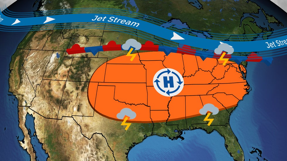
Why Weather Moves Slower Headed Into Summer
Weather patterns move slower in the summertime, which means heavy rainfall is also more common. Here's why that happens.
Why Weather Moves Slower Headed Into Summer
Please enable JavaScript to continue using this application.