Skip to Main Content
_
Sensor Network
Maps & Radar
Severe Weather
News & Blogs
Mobile Apps
More
Search
close
gps_fixed
gps_fixed
Find Nearest Station
Manage Favorite Cities
Log In
Go Ad Free
account_box
Log in
Go Ad Free
settings
Settings
Sensor Network
Maps & Radar
Severe Weather
News & Blogs
Mobile Apps
Historical Weather
star
Current Weather for
Popular
Cities
San Francisco, CA
warning
59
°
F
Partly Cloudy/Wind
Manhattan, NY
50
°
F
Sunny
Schiller Park, IL (60176)
warning
53
°
F
Cloudy
Boston, MA
52
°
F
Clear
Houston, TX
80
°
F
Mostly Cloudy
St James's, England, United Kingdom
47
°
F
Rain Shower
Search
close
gps_fixed
gps_fixed
Find Nearest Station
Manage Favorite Cities
settings
warning
Active Advisory
:
Small Craft Advisory
(
See More
)
--
Feels like
--
--
--
/
--
--
--
--
--
--
--
--
--
--
12AM
6AM
NOON
6PM
12AM
Apr 26
+0000
Apr 27
Full Forecast
Live Updates: Tornadoes Slash Across Nebraska Amid Severe Weather Outbreak
Dangerous and potentially catastrophic severe weather is moving across parts of the Plains and into the Midwest. Here's what's happening right now.
Live Updates: Tornadoes Slash Across Nebraska Amid Severe Weather Outbreak
White-Knuckle Video Of Tornadoes In Texas
A series of tornadoes ravaged parts of Texas, ripping through homes, snapping utility poles and leaving thousands of people without power.
White-Knuckle Video Of Tornadoes In Texas
Severe Outbreak Could Produce Strong Tornadoes Into The Weekend
A classic springtime ignite widespread severe storms through the weekend. Here's what to know.
Severe Outbreak Could Produce Strong Tornadoes Into The Weekend
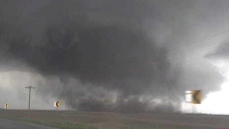
Watch: Huge Iowa Tornado Crosses Highway
Storm chasers captured a large tornado as it cross the road near Shelby, Iowa early Friday evening.
Watch: Huge Iowa Tornado Crosses Highway
Wildfire Risk Looms Over Hurricane-Wrought Acapulco
Nearly every hotel in Acapulco was either destroyed or damaged by Hurricane Otis last year. Now, the struggling resort city is facing a different sort of natural peril: raging wildfires.
Wildfire Risk Looms Over Hurricane-Wrought Acapulco
Please enable JavaScript to continue using this application.