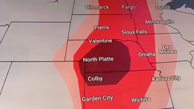
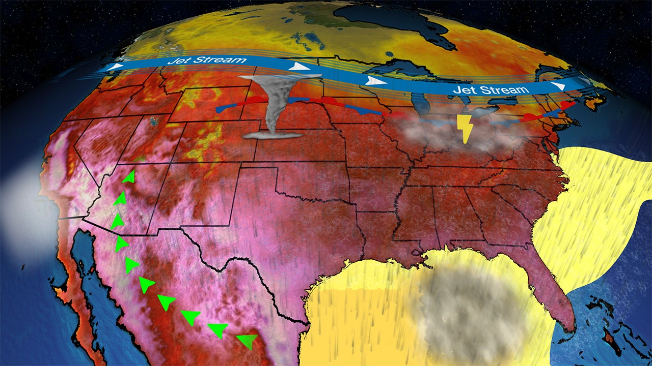
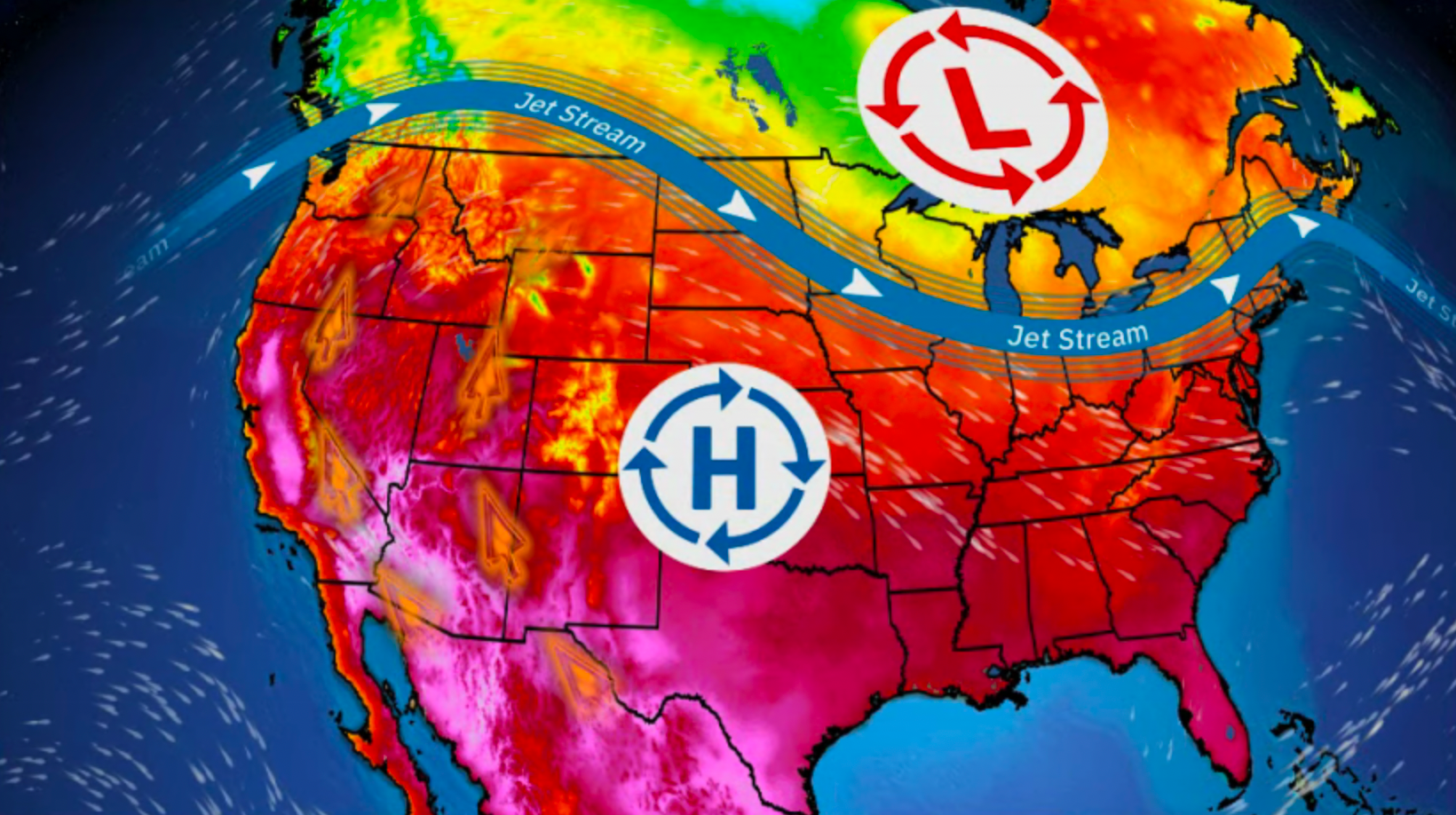
Crivitz, WI

10:34 PM CST on February 03, 2012 (GMT -0600)
Elev: 906 ft
Lon: 88.2° W
Lat: 45.2° N
Rapid Fire Updates™ Updated 10:34 PM CST Make this Location a Weather Sticker® Share:
Your Custom Weather Sticker®

Copy the following lines of HTML:
Weather Summary
Weather Underground midday recap for Friday, February 03, 2012.

A strong winter storm moved into the Central Plains on Friday, which produced heavy precipitation and strong winds. The system pulled moisture and energy in from the Gulf of Mexico and allowed for heavy snow showers to develop in the North and heavy rain showers in the South. Heaviest snowfall developed over Nebraska and Kansas, with snowfall accumulation from 6 to 10 inches. Blizzard warnings were issued in these areas due to strong winds gusts up to 45 mph. In combination with heavy snow, this created white-out conditions and dangerous road conditions across the Central Plains. Meanwhile, to the south, a cold front moved into the Southern Plains. Heavy rain showers developed ahead of this frontal boundary from Texas through the Mid- and Lower Mississippi River Valley. Rainfall totals ranged from 2 to 3 inches across parts of Oklahoma and northern Texas, and Louisiana, while most areas saw 1 to 2 inches of rain. Thunderstorms developed in some areas, but these thunderstorms have not yet turned severe. Alexandria Esle, Louisiana reported the heaviest rainfall with a mid-day total of 3.02 inches.

Behind this system, high pressure built over the West Coast and created another dry and pleasant day. This system pushed moisture offshore, which produced plenty of sunshine and created a warming trend for most of the Pacific Northwest and California. High pressure also covered the East Coast and brought a sunny day with mild temperatures. Highs ranged in the 40s and 50s for most of the Northeast and Mid-Atlantic states.
Crivitz Weather at a Glance
Updated 10:34 PM CST
Elevation
966 ft
Report Station
You are about to report this weather station for bad data.

Please select the information which is incorrect and click 'Submit' otherwise click 'Cancel'.

Cancel

Now
Clear
Clear
Temperature
20.3 °F
Feels Like 20 °F
Wind(mph)
0.0
Sunrise / Set
7:11 AM
5:02 PM
Moon
Waxing Gibbous
Tonight
Partly Cloudy 18 °F
Partly Cloudy
Tomorrow
Partly Cloudy 43 °F
Partly Cloudy
Tomorrow Night
Clear 20 °F
Clear
Sunday
Partly Cloudy 40 | 25 °F
Partly Cloudy
Monday
Clear 43 | 20 °F
Clear
Tuesday
Partly Cloudy 27 | 13 °F
Partly Cloudy
Tomorrow is forecast to be nearly the same temperature as today.
Conditions
Pressure
30.37 in
Visibility
7.0 miles
Clouds
Clear -
Moisture
Humidity
75%
Rainfall
0.04 in
Snow Depth
Not available.
METAR
METAR KMNM 040415Z AUTO 27003KT 7SM CLR M03/M04 A3043 RMK AO1
Don't speak METAR? Read our FAQ.
Weather Radio
Temperature
Windchill
20 °F
Dew Point
14 °F
Wind
Speed / Dir
Calm
Wind Gust
0.0 mph
Health
UV
0 out of 16
Pollen
.10 out of 12
Pollen Forecast
Air Quality
Not available.
Flu Activity
Sporadic
View Flu Map
Loading…
Regional Forecast for Southern Marinette County
Overnight
nt_sunny Mostly clear. Patchy fog late. Lows 18 to 23. Light and variable wind.
Saturday
partlycloudy Mostly sunny. Highs 40 to 45. Light and variable wind becoming west at 5 to 10 mph in the afternoon.
Saturday Night
nt_sunny Mostly clear. Lows 20 to 25. North wind 5 to 10 mph.
Sunday
partlycloudy Mostly sunny. Highs around 40. Northwest wind 5 to 10 mph.
Sunday Night
nt_sunny Mostly clear. Lows in the middle 20s. West wind 5 to 10 mph.
Monday
partlycloudy Mostly sunny. Highs in the lower 40s.
Monday Night
nt_partlycloudy Partly cloudy in the evening...then becoming mostly cloudy. Lows in the lower 20s.
Tuesday
partlycloudy Partly cloudy. Highs in the upper 20s.
Tuesday Night
nt_sunny Mostly clear. Lows in the middle teens.
Wednesday
partlycloudy Partly cloudy. Highs in the lower 30s.
Wednesday Night
nt_partlycloudy Partly cloudy. Lows around 20.
Thursday
partlysunny Partly sunny. Highs in the middle 30s.
Thursday Night
nt_partlycloudy Partly cloudy. Lows in the middle teens.
Friday
partlycloudy Partly cloudy. Highs in the middle 20s.
Source: NWS at 10:16 PM CST on February 3, 2012
Loading…
 
First Previous Last Next  
Updated:  


Forecast
View Calendar 7-Day Weather Forecast for 54114
Saturday, 4
Partly Cloudy
43 | 20 °F
Partly Cloudy
Chance of
Precipitation
0%
Sunday, 5
Partly Cloudy
40 | 25 °F
Partly Cloudy
Chance of
Precipitation
0%
Monday, 6
Clear
43 | 20 °F
Clear
Chance of
Precipitation
0%
Tuesday, 7
Partly Cloudy
27 | 13 °F
Partly Cloudy
Chance of
Precipitation
0%
Wednesday, 8
Partly Cloudy
31 | 18 °F
Partly Cloudy
Chance of
Precipitation
10%
Thursday, 9
Partly Cloudy
32 | 13 °F
Partly Cloudy
Chance of
Precipitation
0%
Friday, 10
Partly Cloudy
25 | NA
Partly Cloudy
Chance of
Precipitation
0%
Source: NWS at 10:16 PM CST on February 3, 2012
Regional Forecast for Southern Marinette County
Overnight
nt_sunny Mostly clear. Patchy fog late. Lows 18 to 23. Light and variable wind.
Saturday
partlycloudy Mostly sunny. Highs 40 to 45. Light and variable wind becoming west at 5 to 10 mph in the afternoon.
Saturday Night
nt_sunny Mostly clear. Lows 20 to 25. North wind 5 to 10 mph.
Hourly Forecast 6AM 12 Noon 6PM 12 Midnight
Temp. | Dew Point 18 | 16 36 | 25 36 | 22 27 | 22
Wind 0 mph NW 2 mph West 5 mph NW 4 mph North
Humidity 92% 61% 58% 84%
Chance of Precip. 0% 0% 0% 0%
Cloud Cover 25% 19% 20% 25%
Conditions Clear Clear Clear Clear
Sunrise & Sunset
7:11 AM
5:02 PM
Source: NWS at 10:16 PM CST on February 3, 2012
Regional Forecast for Southern Marinette County
Sunday
partlycloudy Mostly sunny. Highs around 40. Northwest wind 5 to 10 mph.
Sunday Night
nt_sunny Mostly clear. Lows in the middle 20s. West wind 5 to 10 mph.
Hourly Forecast 6AM 12 Noon 6PM 12 Midnight
Temp. | Dew Point 20 | 18 36 | 23 34 | 23 29 | 22
Wind 5 mph NNW 4 mph NW 5 mph WSW 5 mph West
Humidity 91% 60% 63% 75%
Chance of Precip. 0% 0% 0% 0%
Cloud Cover 24% 27% 22% 22%
Conditions Clear Partly Cloudy Clear Clear
Sunrise & Sunset
7:09 AM
5:03 PM
Source: NWS at 10:16 PM CST on February 3, 2012
Regional Forecast for Southern Marinette County
Monday
partlycloudy Mostly sunny. Highs in the lower 40s.
Monday Night
nt_partlycloudy Partly cloudy in the evening...then becoming mostly cloudy. Lows in the lower 20s.
Hourly Forecast 6AM 12 Noon 6PM 12 Midnight
Temp. | Dew Point 25 | 22 38 | 25 36 | 25 27 | 20
Wind 5 mph West 6 mph WNW 6 mph NNW 6 mph North
Humidity 92% 56% 64% 74%
Chance of Precip. 0% 0% 0% 0%
Cloud Cover 21% 19% 42% 56%
Conditions Clear Clear Partly Cloudy Partly Cloudy
Sunrise & Sunset
7:08 AM
5:05 PM
Source: NWS at 10:16 PM CST on February 3, 2012
Regional Forecast for Southern Marinette County
Tuesday
partlycloudy Partly cloudy. Highs in the upper 20s.
Tuesday Night
nt_sunny Mostly clear. Lows in the middle teens.
Hourly Forecast 6AM 12 Noon 6PM 12 Midnight
Temp. | Dew Point 20 | 13 25 | 11 22 | 9 18 | 7
Wind 7 mph North 6 mph North 5 mph NNE 0 mph NW
Humidity 77% 52% 56% 63%
Chance of Precip. 0% 0% 0% 0%
Cloud Cover 55% 42% 34% 30%
Conditions Partly Cloudy Partly Cloudy Partly Cloudy Partly Cloudy
Sunrise & Sunset
7:07 AM
5:06 PM
Source: NWS at 10:16 PM CST on February 3, 2012
Regional Forecast for Southern Marinette County
Wednesday
partlycloudy Partly cloudy. Highs in the lower 30s.
Wednesday Night
nt_partlycloudy Partly cloudy. Lows around 20.
Hourly Forecast 6AM 12 Noon 6PM 12 Midnight
Temp. | Dew Point 13 | 7 27 | 13 27 | 16 22 | 16
Wind 1 mph WSW 6 mph SW 6 mph SW 6 mph WSW
Humidity 76% 54% 62% 80%
Chance of Precip. 0% 10% 10% 10%
Cloud Cover 37% 39% 50% 47%
Conditions Partly Cloudy Partly Cloudy Partly Cloudy Partly Cloudy
Sunrise & Sunset
7:06 AM
5:08 PM
Source: NWS at 10:16 PM CST on February 3, 2012
Regional Forecast for Southern Marinette County
Thursday
partlysunny Partly sunny. Highs in the middle 30s.
Thursday Night
nt_partlycloudy Partly cloudy. Lows in the middle teens.
Hourly Forecast 6AM 12 Noon 6PM 12 Midnight
Temp. | Dew Point 18 | 16 29 | 18 27 | 14 18 | 14
Wind 6 mph WSW 9 mph West 7 mph NW 6 mph NW
Humidity 91% 65% 59% 84%
Chance of Precip. 10% 0% 0% 0%
Cloud Cover 58% 54% 49% 31%
Conditions Partly Cloudy Partly Cloudy Partly Cloudy Partly Cloudy
Sunrise & Sunset
7:06 AM
5:08 PM
Source: NWS at 10:16 PM CST on February 3, 2012
Regional Forecast for Southern Marinette County
Friday
partlycloudy Partly cloudy. Highs in the middle 20s.
Hourly Forecast 6AM 12 Noon 6PM 12 Midnight
Temp. | Dew Point 13 | 9 22 | 7 27 | 14 18 | 14
Wind 6 mph NW 6 mph NW 7 mph NW 6 mph NW
Humidity 87% 50% 59% 84%
Chance of Precip. 0% 10% 0% 0%
Cloud Cover 34% 40% 49% 31%
Conditions Partly Cloudy Partly Cloudy Partly Cloudy Partly Cloudy
Sunrise & Sunset
7:06 AM
5:08 PM
BestForecast (what's this?)
Nearby
History & Almanac
February 3, 2012 Max Temp Min Temp
Normal (KMNM) 26 °F 11 °F
Record (KMNM) 44 °F (2005) -13 °F (1965)
Yesterday 36.1 °F 21.6 °F
Choose a date
Earthquake Activity
City Distance Mag. Time & Date
No recent earthquake activity has been reported nearby.
Minimum magnitude displayed is 2.5.
Coastal Water Temperatures
Place Temperature
Menominee, MI 32.0 °F
Astronomy
Feb. 03, 2012 Rise Set
Actual Time 7:11 AM CST 5:02 PM CST
Civil Twilight 6:39 AM CST 5:33 PM CST
Nautical Twilight 6:04 AM CST 6:08 PM CST
Astronomical Twilight 5:30 AM CST 6:43 PM CST
Moon 12:57 PM CST (2/3) 3:53 AM CST (2/3)
Length Of Visible Light 10h 53m
Length of Day
9h 51m
Tomorrow will be 2m 41s longer.
Waxing Gibbous, 85% of the Moon is Illuminated
Today
Waxing Gibbous
Feb 7
Full
Feb 14
Last Quarter
Feb 21
New
Feb 29
First Quarter
Today's Extremes
State Highs State Lows
42 °F
Hayward
41 °F
Phillips
39 °F
Shawano
38 °F
Wausau
21 °F
Tomahawk
21 °F
Eagle River
21 °F
Land O' Lakes
21 °F
Rhinelander
21 °F
Antigo
Source: NWS
Snow Depth
Station Depth Elevation
No new snow has been reported.
WunderPhotos®
Cold as Ice...
The snow and sun
Uploaded by: henkhoekstra
1,453,215 photos uploaded!
WunderBlogs®

There are no recent blogs in this area. Why not create your own?

Travel & Activities
Travel Planning
Destination? *
When are you going?
to
Is there an activity you would like to explore?
* Required field
Aviation
City Temp. Conditions Updated
Menominee 27 °F Clear 10:15 PM CST
Shawano 25 °F Clear 10:35 PM CST
Iron Mountain 16 °F Clear 9:54 PM CST
Sturgeon Bay 27 °F Clear 10:15 PM CST
Flight To ETA Status
No flights were found.
Flight Tracker by FlightAware FlightAware
Type Condition
Flight Rule: VFR (KMNM)
Wind Speed: 3.0 kts.
Wind Dir: 86° (East)
Ceiling: Unlimited

METAR KMNM 040415Z AUTO 27003KT 7SM CLR M03/M04 A3043 RMK AO1

Nearby Events
Event Date Forecast
No events within 10 mi of location. View all events.
Event data courtesy eviesays.com
Sports
Event Date Forecast
Giants vs. Patriots 6:30 PM EST on February 05, 2012 Clear, 38 °F
Event Date Forecast
Budweiser Shootout 12:00 AM EST on February 18, 2012 Average High 71° F/ 21° C
Gatorade Duel 2 12:00 AM EST on February 23, 2012 Average High 70° F/ 21° C
Event Date Forecast
Waste Management Phoenix Open 8:30 AM MST on February 04, 2012 Clear, 45 °F
Waste Management Phoenix Open 8:30 AM MST on February 05, 2012 Partly Cloudy, 47 °F
Weather Stations
Station Location Temp. Windchill Dew Point Humidity Wind Precipitation Elevation Updated Type Website
Athelstane Township, Athelstane, WI 20.3 °F 20 °F 14 °F 75% East  at  0.0 mph 0.00 in / hr 966 ft 10:34 PM CST Rapid Fire
RAWS WAUSAUKEE WI, Wausaukee, WI 22 °F 22 °F 20 °F 92% West  at  1 mph 0.00 in / hr 763 ft 9:05 PM CST MADIS
Lakewood, WI 24.2 °F 24 °F 20 °F 84% NNW  at  0.0 mph 0.00 in / hr 1219 ft 10:30 PM CST Normal
APRSWXNET Dunbar WI , Dunbar, WI - - - - North  at  - 0.00 in / hr 1042 ft 9:55 PM CST MADIS
Would you like to share your weather data with the rest of the world? Add Your Weather Station!