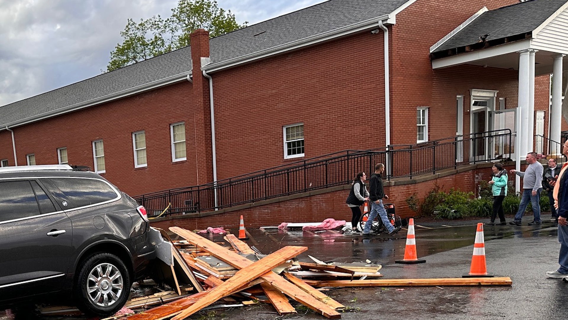
Waterbury, VT

12:00 AM EST on February 04, 2012 (GMT -0500)
Elev: 427 ft
Lon: 72.8° W
Lat: 44.3° N
Rapid Fire Updates™ Updated 12:00 AM EST Make this Location a Weather Sticker® Share:
Your Custom Weather Sticker®

Copy the following lines of HTML:
Weather Summary
Weather Underground midday recap for Friday, February 03, 2012.

A strong winter storm moved into the Central Plains on Friday, which produced heavy precipitation and strong winds. The system pulled moisture and energy in from the Gulf of Mexico and allowed for heavy snow showers to develop in the North and heavy rain showers in the South. Heaviest snowfall developed over Nebraska and Kansas, with snowfall accumulation from 6 to 10 inches. Blizzard warnings were issued in these areas due to strong winds gusts up to 45 mph. In combination with heavy snow, this created white-out conditions and dangerous road conditions across the Central Plains. Meanwhile, to the south, a cold front moved into the Southern Plains. Heavy rain showers developed ahead of this frontal boundary from Texas through the Mid- and Lower Mississippi River Valley. Rainfall totals ranged from 2 to 3 inches across parts of Oklahoma and northern Texas, and Louisiana, while most areas saw 1 to 2 inches of rain. Thunderstorms developed in some areas, but these thunderstorms have not yet turned severe. Alexandria Esle, Louisiana reported the heaviest rainfall with a mid-day total of 3.02 inches.

Behind this system, high pressure built over the West Coast and created another dry and pleasant day. This system pushed moisture offshore, which produced plenty of sunshine and created a warming trend for most of the Pacific Northwest and California. High pressure also covered the East Coast and brought a sunny day with mild temperatures. Highs ranged in the 40s and 50s for most of the Northeast and Mid-Atlantic states.
Waterbury Weather at a Glance
Updated 12:00 AM EST
Elevation
1037 ft
Report Station
You are about to report this weather station for bad data.

Please select the information which is incorrect and click 'Submit' otherwise click 'Cancel'.

Cancel

Now
Light Snow
Light Snow Mist
Temperature
27.3 °F
Feels Like 27 °F
Wind(mph)
0.0
Sunrise / Set
7:06 AM
5:04 PM
Moon
Waxing Gibbous
Tonight
Chance of Snow 20 °F
Chance of Snow
50% chance of precipitation
Saturday
Partly Cloudy 27 °F
Partly Cloudy
Saturday Night
Partly Cloudy 7 °F
Partly Cloudy
Sunday
Partly Cloudy 27 | 11 °F
Partly Cloudy
Monday
Partly Cloudy 38 | 20 °F
Partly Cloudy
Tuesday
Chance of Snow 25 | 2 °F
Chance of Snow
20% chance of precipitation
Today is forecast to be Cooler than yesterday.
Conditions
Pressure
30.25 in
Visibility
4.0 miles
Clouds
Mostly Cloudy 1800 ft
Overcast 2300 ft
Moisture
Humidity
93%
Rainfall
-
Not available.
Snow Depth
Not available.
METAR
METAR KMPV 040451Z AUTO 00000KT 4SM -SN BR BKN018 OVC023 M03/M04 A3023 RMK AO2 SLP254 P0000 T10331044 410281133
Don't speak METAR? Read our FAQ.
Weather Radio
Temperature
Windchill
27 °F
Dew Point
26 °F
Wind
Speed / Dir
Calm
Wind Gust
2.0 mph
Health
UV
0 out of 16
Pollen
.10 out of 12
Pollen Forecast
Ozone
Good
PM2.5
Good
Flu Activity
Sporadic
View Flu Map
Loading…
Regional Forecast for Washington
Saturday
cloudy Mostly cloudy in the morning...then becoming partly sunny. Highs in the mid 20s. Light and variable winds...becoming northwest around 10 mph in the afternoon.
Saturday Night
nt_sunny Clear until midnight...then becoming partly cloudy. Lows around 5 above. Light and variable winds.
Sunday
partlycloudy Mostly sunny. Highs in the mid 20s. Light and variable winds.
Sunday Night
nt_sunny Mostly clear. Lows around 10 above. Light and variable winds.
Monday
partlycloudy Mostly sunny. Highs in the mid 30s.
Monday Night
nt_chancesnow Partly cloudy with a 30 percent chance of snow showers. Lows 15 to 20.
Tuesday
partlysunny Partly sunny. Highs in the lower 20s.
Tuesday Night
nt_sunny Mostly clear. Lows around zero.
Wednesday
sunny Sunny. Highs in the upper 20s.
Wednesday Night
nt_sunny Mostly clear. Lows around 10 above.
Thursday
partlysunny Partly sunny. Highs in the lower 30s.
Thursday Night
nt_chancesnow Partly cloudy with a 30 percent chance of snow showers. Lows around 20.
Friday
chancesnow Cloudy with a 30 percent chance of snow showers. Highs in the upper 20s.
Source: NWS at 9:18 PM EST on February 3, 2012
Loading…
 
First Previous Last Next  
Updated:  


Forecast
View Calendar 7-Day Weather Forecast for 05671
Saturday, 4
Partly Cloudy
27 | 7 °F
Partly Cloudy
Chance of
Precipitation
10%
Sunday, 5
Partly Cloudy
27 | 11 °F
Partly Cloudy
Chance of
Precipitation
0%
Monday, 6
Partly Cloudy
38 | 20 °F
Partly Cloudy
Chance of
Precipitation
10%
Tuesday, 7
Chance of Snow
25 | 2 °F
Chance of Snow
Chance of
Precipitation
20%
Wednesday, 8
Clear
29 | 11 °F
Clear
Chance of
Precipitation
10%
Thursday, 9
Chance of Snow
34 | 22 °F
Chance of Snow
Chance of
Precipitation
20%
Friday, 10
Chance of Snow
29 | NA
Chance of Snow
Chance of
Precipitation
30%
Source: NWS at 9:18 PM EST on February 3, 2012
Regional Forecast for Washington
Saturday
cloudy Mostly cloudy in the morning...then becoming partly sunny. Highs in the mid 20s. Light and variable winds...becoming northwest around 10 mph in the afternoon.
Saturday Night
nt_sunny Clear until midnight...then becoming partly cloudy. Lows around 5 above. Light and variable winds.
Hourly Forecast 6AM 12 Noon 6PM 12 Midnight
Temp. | Dew Point 20 | 13 23 | 11 20 | 8 12 | 6
Wind 4 mph NW 7 mph NNW 3 mph NNW 0 mph North
Humidity 76% 58% 58% 73%
Chance of Precip. 50% 10% 10% 0%
Cloud Cover 88% 48% 0% 12%
Conditions Chance of Snow Partly Cloudy Clear Clear
Sunrise & Sunset
7:06 AM
5:04 PM
Source: NWS at 9:18 PM EST on February 3, 2012
Regional Forecast for Washington
Sunday
partlycloudy Mostly sunny. Highs in the mid 20s. Light and variable winds.
Sunday Night
nt_sunny Mostly clear. Lows around 10 above. Light and variable winds.
Hourly Forecast 6AM 12 Noon 6PM 12 Midnight
Temp. | Dew Point 9 | 4 23 | 6 22 | 9 14 | 9
Wind 0 mph NNE 4 mph East 3 mph NNW 0 mph NW
Humidity 79% 50% 56% 80%
Chance of Precip. 0% 0% 0% 10%
Cloud Cover 37% 26% 0% 16%
Conditions Partly Cloudy Partly Cloudy Clear Clear
Sunrise & Sunset
7:05 AM
5:05 PM
Source: NWS at 9:18 PM EST on February 3, 2012
Regional Forecast for Washington
Monday
partlycloudy Mostly sunny. Highs in the mid 30s.
Monday Night
nt_chancesnow Partly cloudy with a 30 percent chance of snow showers. Lows 15 to 20.
Hourly Forecast 6AM 12 Noon 6PM 12 Midnight
Temp. | Dew Point 15 | 11 31 | 16 33 | 18 26 | 16
Wind 1 mph SW 7 mph SSW 5 mph SSW 4 mph SW
Humidity 86% 55% 54% 66%
Chance of Precip. 10% 10% 10% 10%
Cloud Cover 32% 8% 12% 43%
Conditions Partly Cloudy Clear Clear Chance of Snow
Sunrise & Sunset
7:03 AM
5:06 PM
Source: NWS at 9:18 PM EST on February 3, 2012
Regional Forecast for Washington
Tuesday
partlysunny Partly sunny. Highs in the lower 20s.
Tuesday Night
nt_sunny Mostly clear. Lows around zero.
Hourly Forecast 6AM 12 Noon 6PM 12 Midnight
Temp. | Dew Point 21 | 14 24 | 8 19 | 5 12 | 0
Wind 2 mph NW 5 mph NNW 7 mph NNW 1 mph NNW
Humidity 70% 51% 52% 56%
Chance of Precip. 30% 30% 20% 20%
Cloud Cover 59% 68% 21% 13%
Conditions Chance of Snow Chance of Snow Chance of Snow Clear
Sunrise & Sunset
7:02 AM
5:08 PM
Source: NWS at 9:18 PM EST on February 3, 2012
Regional Forecast for Washington
Wednesday
sunny Sunny. Highs in the upper 20s.
Wednesday Night
nt_sunny Mostly clear. Lows around 10 above.
Hourly Forecast 6AM 12 Noon 6PM 12 Midnight
Temp. | Dew Point 8 | -2 22 | 1 23 | 5 19 | 7
Wind 0 mph North 3 mph NE 1 mph ENE 1 mph SSE
Humidity 61% 40% 45% 59%
Chance of Precip. 10% 10% 10% 10%
Cloud Cover 11% 12% 0% 0%
Conditions Clear Clear Clear Clear
Sunrise & Sunset
7:01 AM
5:09 PM
Source: NWS at 9:18 PM EST on February 3, 2012
Regional Forecast for Washington
Thursday
partlysunny Partly sunny. Highs in the lower 30s.
Thursday Night
nt_chancesnow Partly cloudy with a 30 percent chance of snow showers. Lows around 20.
Hourly Forecast 6AM 12 Noon 6PM 12 Midnight
Temp. | Dew Point 15 | 7 28 | 12 29 | 14 26 | 16
Wind 1 mph SSW 4 mph South 3 mph SW 4 mph SSW
Humidity 71% 52% 51% 63%
Chance of Precip. 10% 10% 20% 20%
Cloud Cover 18% 26% 40% 43%
Conditions Clear Chance of Snow Chance of Snow Chance of Snow
Sunrise & Sunset
7:01 AM
5:09 PM
Source: NWS at 9:18 PM EST on February 3, 2012
Regional Forecast for Washington
Friday
chancesnow Cloudy with a 30 percent chance of snow showers. Highs in the upper 20s.
Hourly Forecast 6AM 12 Noon 6PM 12 Midnight
Temp. | Dew Point 23 | 16 28 | 16 27 | 16 26 | 16
Wind 4 mph SSW 6 mph SW 4 mph WNW 4 mph SSW
Humidity 73% 62% 62% 63%
Chance of Precip. 30% 30% 30% 20%
Cloud Cover 62% 87% 84% 43%
Conditions Chance of Snow Chance of Snow Chance of Snow Chance of Snow
Sunrise & Sunset
7:01 AM
5:09 PM
BestForecast (what's this?)
Nearby
History & Almanac
February 4, 2012 Max Temp Min Temp
Normal (KMPV) 24 °F 3 °F
Record (KMPV) 55 °F (1991) -21 °F (1971)
Yesterday 28.8 °F 11.7 °F
Choose a date
Earthquake Activity
City Distance Mag. Time & Date
No recent earthquake activity has been reported nearby.
Minimum magnitude displayed is 2.5.
Air Quality
  Air Quality AQ Index Pollutant
Yesterday Good
OZONE
Yesterday Good
PM2.5
Current Good
PM2.5
Current Good
OZONE
Friday Good
PM2.5
Saturday Good
PM2.5
Sunday Good
PM2.5
Monday Good
PM2.5
Astronomy
Feb. 04, 2012 Rise Set
Actual Time 7:06 AM EST 5:04 PM EST
Civil Twilight 6:35 AM EST 5:34 PM EST
Nautical Twilight 6:01 AM EST 6:09 PM EST
Astronomical Twilight 5:27 AM EST 6:43 PM EST
Moon 1:54 PM EST 4:34 AM EST
Length Of Visible Light 10h 59m
Length of Day
9h 57m
Tomorrow will be 2m 37s longer.
Waxing Gibbous, 85% of the Moon is Illuminated
Today
Waxing Gibbous
Feb 7
Full
Feb 14
Last Quarter
Feb 21
New
Feb 29
First Quarter
Yesterday's Extremes
State Highs State Lows
35 °F
Bennington
33 °F
Rutland
33 °F
Springfield
30 °F
Burlington
28 °F
Morrisville
7 °F
Morrisville
9 °F
Montpelier
10 °F
Newport
11 °F
Lyndonville
12 °F
Highgate
Source: NWS
Snow Depth
Station Depth Elevation
No new snow has been reported.
WunderPhotos®
Cold as Ice...
The snow and sun
Uploaded by: henkhoekstra
1,453,217 photos uploaded!
WunderBlogs®
Please visit the East Street We...
By johnnylion 2 days ago
Travel & Activities
Travel Planning
Destination? *
When are you going?
to
Is there an activity you would like to explore?
* Required field
Aviation
City Temp. Conditions Updated
Montpelier 26 °F Light Snow Mist 11:51 PM EST
Morrisville 26 °F Light Snow 11:54 PM EST
Burlington 28 °F Light Snow 11:54 PM EST
St. Johnsbury 26 °F N/A 11:54 PM EST
Flight To ETA Status
No flights were found.
Flight Tracker by FlightAware FlightAware
Type Condition
Flight Rule: MVFR (KMPV)
Wind Speed: 0.0 kts.
Wind Dir: 248° (WSW)
Ceiling: 1800 ft

METAR KMPV 040451Z AUTO 00000KT 4SM -SN BR BKN018 OVC023 M03/M04 A3023 RMK AO2 SLP254 P0000 T10331044 410281133

Nearby Events
Event Date Forecast
No events within 10 mi of location. View all events.
Event data courtesy eviesays.com
Sports
Event Date Forecast
Giants vs. Patriots 6:30 PM EST on February 05, 2012 Clear, 38 °F
Event Date Forecast
Budweiser Shootout 12:00 AM EST on February 18, 2012 Average High 71° F/ 21° C
Gatorade Duel 2 12:00 AM EST on February 23, 2012 Average High 70° F/ 21° C
Event Date Forecast
Waste Management Phoenix Open 8:30 AM MST on February 04, 2012 Clear, 45 °F
Waste Management Phoenix Open 8:30 AM MST on February 05, 2012 Partly Cloudy, 47 °F
Weather Stations
Station Location Temp. Windchill Dew Point Humidity Wind Precipitation Elevation Updated Type Website
Evergreen Woods, Waterbury Center, VT 27.3 °F 27 °F 26 °F 93% WSW  at  0.0 mph 0.00 in / hr 1037 ft 12:00 AM EST Rapid Fire  
HADS MAD RIVER NEAR MORETOWN 2NNE VT, Moretown, VT 27 °F 27 °F - - North  at  - 0.00 in / hr 543 ft 11:00 PM EST MADIS
Stevens Brook Road, Moretown, VT 25.9 °F 26 °F 24 °F 91% East  at  0.0 mph 0.00 in / hr 680 ft 9:29 PM EST Normal
Emilys Bridge, Stowe, VT 27.8 °F 28 °F 24 °F 85% SW  at  0.0 mph 0.00 in / hr 950 ft 12:00 AM EST Rapid Fire  
MesoWest I-89 Bolton , Richmond, VT 28 °F 23 °F 25 °F 88% WNW  at  4 mph 0.00 in / hr 317 ft 11:25 PM EST MADIS
South Hill Rd, Moretown, VT 28.2 °F 28 °F 25 °F 89% WSW  at  0.0 mph 0.00 in / hr 1380 ft 12:00 AM EST Rapid Fire  
Worcester Range in North Central Vermont, Worcester, VT 26.3 °F 22 °F 23 °F 87% NNE  at  3.5 mph 0.00 in / hr 1375 ft 12:00 AM EST Rapid Fire
APRSWXNET Worcester VT , Worcester, VT 27 °F 27 °F 23 °F 85% SW  at  2 mph 0.00 in / hr 1374 ft 11:29 PM EST MADIS
APRSWXNET S. Duxbury VT , Moretown, VT 29 °F 29 °F 26 °F 88% South  at  0 mph 0.00 in / hr 799 ft 11:32 PM EST MADIS
East Street, Huntington, VT 27.3 °F 27 °F 26 °F 95% West  at  0.0 mph 0.00 in / hr 854 ft 12:00 AM EST Rapid Fire
Murray Hill, Montpelier, VT 27.1 °F 27 °F 26 °F 94% NE  at  0.0 mph 0.00 in / hr 800 ft 12:00 AM EST Rapid Fire
APRSWXNET Jericho VT , Jericho, VT 26 °F 26 °F 24 °F 93% NNW  at  0 mph 0.00 in / hr 826 ft 11:33 PM EST MADIS
Fields Lane, Jericho, VT 25.5 °F 26 °F 18 °F 73% North  at  0.0 mph 0.00 in / hr 820 ft 11:50 PM EST Normal  
MesoWest I-89 Berlin , Montpelier, VT 25 °F 25 °F 22 °F 88% South  at  0 mph 0.00 in / hr 1037 ft 11:25 PM EST MADIS
Norm's Weather, Waitsfield, VT 26.0 °F 26 °F 21 °F 81% North  at  0.0 mph 0.00 in / hr 1150 ft 12:00 AM EST Rapid Fire
Jackson Hill, Underhill, VT 26.1 °F 26 °F 18 °F 72% North  at  0.0 mph 0.00 in / hr 1096 ft 12:00 AM EST Rapid Fire  
APRSWXNET East Montpelier VT , North Montpelier, VT 26 °F 21 °F 23 °F 90% NW  at  4 mph 0.00 in / hr 875 ft 11:31 PM EST MADIS
Jericho Center, Jericho, VT 28.7 °F 29 °F 18 °F 65% NNW  at  0.0 mph 0.00 in / hr 775 ft 11:37 PM EST Normal
Mud City OBH, Morrisville, VT 26.6 °F 27 °F 26 °F 98% ESE  at  0.0 mph - / hr 1100 ft 11:55 PM EST Normal  
Sugar Hill, Underhill, VT 26.2 °F 26 °F 22 °F 85% North  at  0.0 mph 0.00 in / hr 988 ft 12:00 AM EST Normal  
Bridle Trail, Underhill, VT 25.6 °F 26 °F 23 °F 89% SE  at  0.0 mph 0.00 in / hr 919 ft 11:51 PM EST Normal
MesoWest I-89 Williston , Williston, VT 27 °F 27 °F 23 °F 86% SSE  at  2 mph 0.00 in / hr 499 ft 11:25 PM EST MADIS
Deer Crossing, Essex, VT 27.1 °F 27 °F 21 °F 77% ENE  at  0.0 mph 0.00 in / hr 512 ft 11:45 PM EST Normal
Williston Road, Williston, VT 28.6 °F 29 °F 26 °F 88% ESE  at  0.0 mph 0.00 in / hr 413 ft 12:00 AM EST Rapid Fire  
RAWS ELMORE VT, Morrisville, VT 25 °F 20 °F 22 °F 89% NNE  at  4 mph 0.00 in / hr 1200 ft 11:02 PM EST MADIS
Smuggs View, Jeffersonville, VT 26.6 °F 27 °F 23 °F 85% ESE  at  0.4 mph 0.00 in / hr 1000 ft 12:00 AM EST Rapid Fire  
TenBends, Hyde Park, VT 26.3 °F 26 °F 25 °F 94% ESE  at  0.0 mph 0.00 in / hr 600 ft 11:51 PM EST Normal  
HADS ELDER HILL SWAMP RAIN NEAR LINCO VT, Warren, VT - - - - North  at  - 0.00 in / hr 1399 ft 11:15 PM EST MADIS
Maple Street Park, Essex Junction, VT 28.7 °F 29 °F - - North  at  0.0 mph 0.00 in / hr 347 ft 11:31 PM EST Normal
Fire Station in Village, Marshfield, VT 26.0 °F 26 °F 24 °F 92% ENE  at  0.0 mph 0.00 in / hr 812 ft 11:59 PM EST Normal  
Phen Basin, Fayston, VT 26.7 °F 27 °F 23 °F 86% South  at  2.0 mph 0.00 in / hr 1630 ft 12:00 AM EST Rapid Fire  
Stowe, VT 26.4 °F 19 °F 23 °F 86% NNE  at  7.0 mph 0.00 in / hr 1640 ft 12:00 AM EST Rapid Fire  
Conway Road, Starksboro, VT 24.9 °F 25 °F 23 °F 91% South  at  0.0 mph 0.00 in / hr 1780 ft 11:56 PM EST Normal  
APRSWXNET Waitsfield VT , Waitsfield, VT 27 °F 27 °F 22 °F 82% NW  at  1 mph 0.00 in / hr 3772 ft 11:26 PM EST MADIS
Would you like to share your weather data with the rest of the world? Add Your Weather Station!