Skip to Main Content
_
Sensor Network
Maps & Radar
Severe Weather
News & Blogs
Mobile Apps
More
Search
close
gps_fixed
gps_fixed
Find Nearest Station
Manage Favorite Cities
Log In
Go Ad Free
account_box
Log in
Go Ad Free
settings
Settings
Sensor Network
Maps & Radar
Severe Weather
News & Blogs
Mobile Apps
Historical Weather
star
Current Weather for
Popular
Cities
San Francisco, CA
warning
65
°
F
Sunny
Manhattan, NY
75
°
F
Sunny
Schiller Park, IL (60176)
warning
76
°
F
Cloudy
Boston, MA
68
°
F
Mostly Cloudy
Houston, TX
warning
72
°
F
Showers in the Vicinity
St James's, England, United Kingdom
54
°
F
Cloudy
Search
close
gps_fixed
gps_fixed
Find Nearest Station
Manage Favorite Cities
settings
warning
Active Advisory
:
Small Craft Advisory
(
See More
)
--
Feels like
--
--
--
/
--
--
--
--
--
--
--
--
--
--
12AM
6AM
NOON
6PM
12AM
May 2
+0000
May 3
Full Forecast
Flooding Submerges Houston Area; Driver Takes On Floodwaters, Loses
Flash flooding and river flooding are ongoing across East Texas.
Flooding Submerges Houston Area; Driver Takes On Floodwaters, Loses
Child's 'Monster' Turns Out To Be Homeowner's Nightmare
A toddler's innocent claim of “monsters” in her bedroom unraveled a chilling discovery in a family’s century-old farmhouse.
Child's 'Monster' Turns Out To Be Homeowner's Nightmare
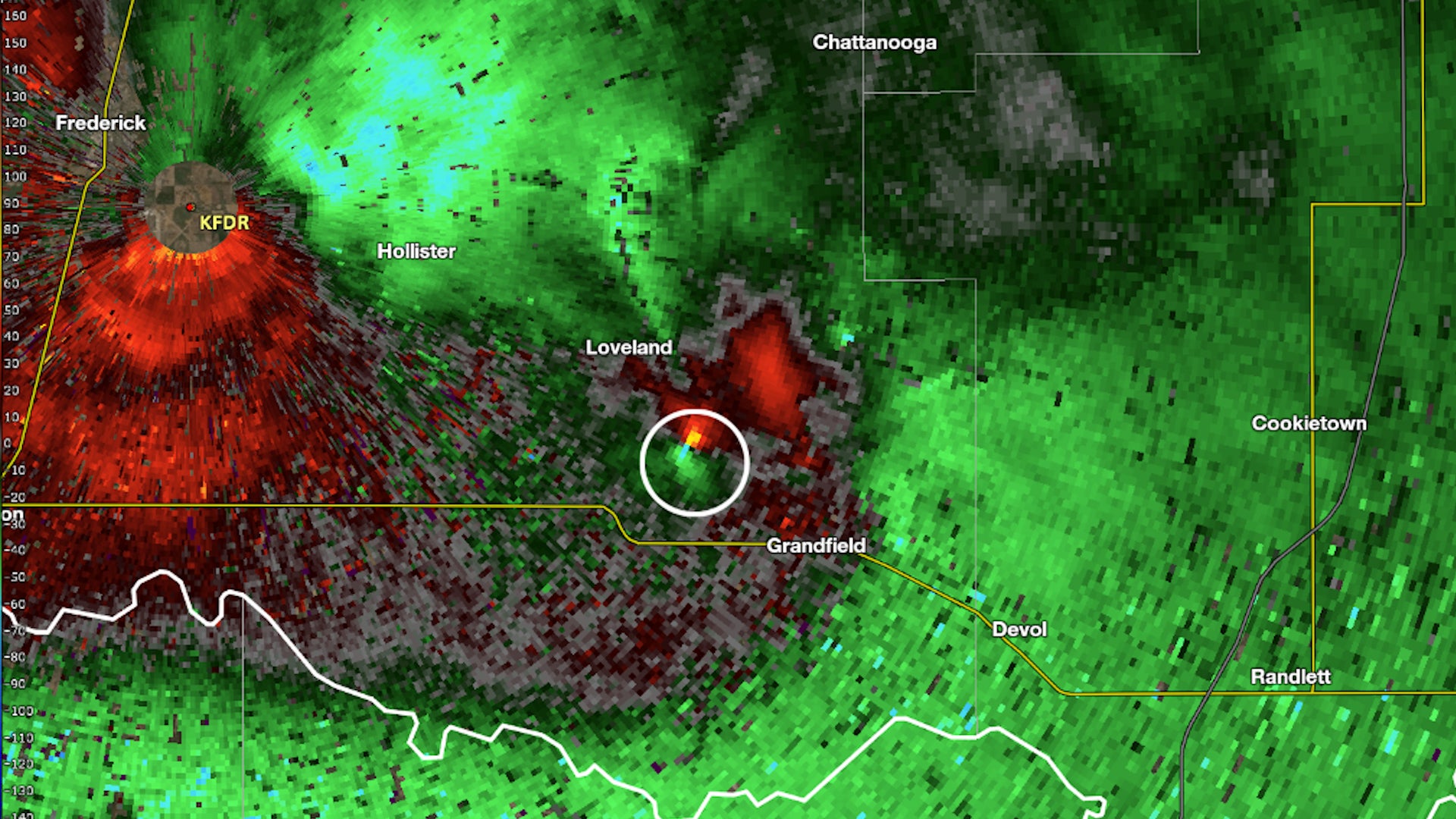
Oklahoma Tornado Did Something That 99% Don't Do
A tornado in Oklahoma Tuesday evening didn't spin in the normal direction we see in the Northern Hemisphere. It was in the rare 1% of tornadoes that spin the opposite direction.
Oklahoma Tornado Did Something That 99% Don't Do
Tourists Can Visit The House From ‘Up’ This Summer
Tourists can visit the house from “Up” this summer as part of Airbnb’s new “Icons” series. A crane lifts the home into the air.
Tourists Can Visit The House From ‘Up’ This Summer
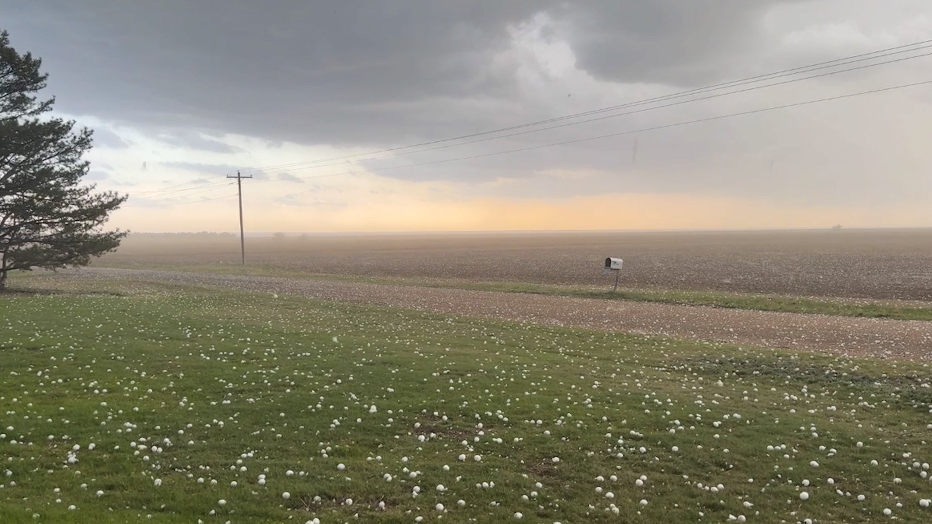
Window-Smashing Hailstones Rain Down In Kansas Plains
Storm chasers captured intense hail as storms moved across the Plains. Reports indicate these stones were baseball size or larger.
Window-Smashing Hailstones Rain Down In Kansas Plains
Please enable JavaScript to continue using this application.