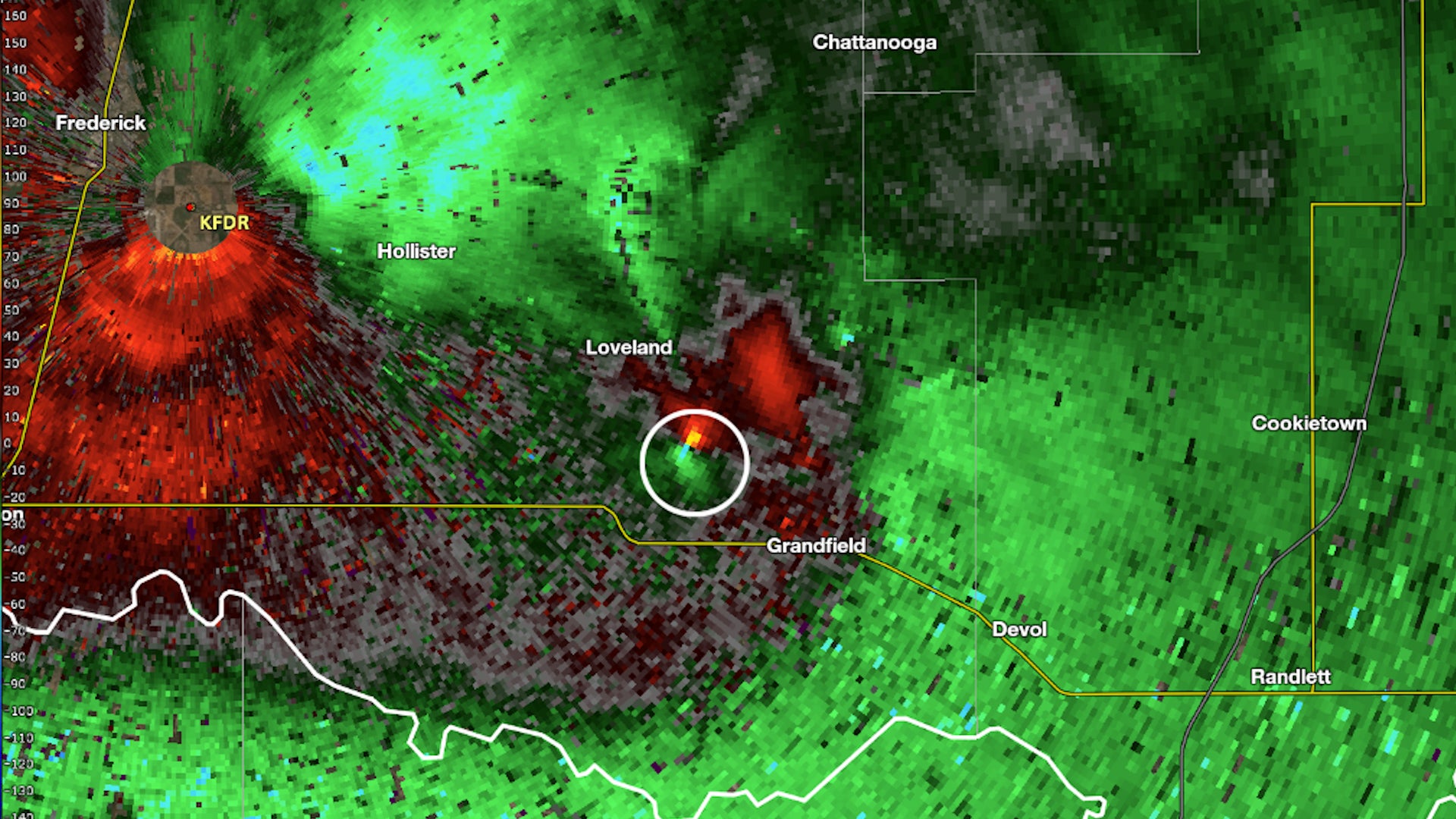
Canandaigua, NY

3:43 AM EDT on May 27, 2012 (GMT -0400)
Elev: 991 ft
Lon: 77.3° W
Lat: 42.8° N
Source
Rapid Fire Updates™
Updated 3:42 AM EDT Get Free Weather Stickers® Share:
Your Custom Weather Sticker®

Copy the following lines of HTML:
Tropical Weather: Subtropical Storm Beryl (North Atlantic) Tropical Storm Sanvu (Western Pacific)
Weather Summary
Weather Underground Forecast for Sunday, May 27, 2012. More interesting weather for many parts of the country is expected Sunday. Subtropical Storm Beryl will continue on its path toward the northeast coast of Florida near Georgia. It is expected to make landfall with tropical storm strength winds either late Sunday night or early Monday morning. This storm will not be a signficant wind threat, and the rain associated with it will mostly be a blessing to this region as it has suffered through an exceptional drought.

Elsewhere, an intense heat wave will continue for the Plains and Southeast while also spreading northward into the Ohio Valley and Upper Midwest. Maximum temperature records are most likely to be broken for many areas as temperatures will soar into the 90s and 100s. Even more dangerous will be the heat index values over 100 degrees. The heat index tells you how hot the air feels. The more humid the weather, the higher the heat index will soar. Thankfully, many areas will not experience the extremely high humidity common during the Summer months.

In the West, a strong storm will move through the Northern Rockies and into the Dakotas. This storm will bring widespread rain and even some snow from Idaho through Minnesota. The associated cold front will move through the Plains, possibly instigating some strong thunderstorms that could become severe.

The Northeast will rise into the 70s and 80s, while the Southeast and Southern Plains will see temperatures in the 90s and 100s. The Northwest will rise into the 70s.

Canandaigua Weather at a Glance

Updated 3:42 AM EDT
Weather Station - report
Elevation
1420 ft
Report Station
You are about to report this weather station for bad data.

Please select the information which is incorrect and click 'Submit' otherwise click 'Cancel'.

Cancel

Now
Clear
Clear
Temperature
62.2 °F
Feels Like 62.2 °F
Wind(mph)
0.0
Sunrise / Set
5:35 AM
8:37 PM
Moon
Waxing Crescent
Tonight
Partly Cloudy 57 °F
Partly Cloudy
Sunday
Thunderstorm 88 °F
T-storms
60% chance of precipitation
Sunday Night
Chance of a Thunderstorm 64 °F
Chance of T-storms
40% chance of precipitation
Monday
Chance of a Thunderstorm 93 | 72 °F
Chance of T-storms
30% chance of precipitation
Tuesday
Thunderstorm 88 | 64 °F
T-storms
60% chance of precipitation
Wednesday
Chance of Rain 79 | 54 °F
Chance of Rain
20% chance of precipitation
Today is forecast to be Warmer than yesterday.
Conditions
Pressure
30.14 in
Visibility
10.0 miles
Clouds
Clear -
Moisture
Humidity
57%
Rainfall
0.00 in
Snow Depth
Not available.
METAR
METAR KPEO 270653Z AUTO 24003KT 10SM CLR 14/11 A3015 RMK AO2 SLP206 T01440106 TSNO
Don't speak METAR? Read our FAQ.
Weather Radio
Temperature
Temperature
62.2 °F
Dew Point
47 °F
Wind
Speed / Dir
Calm
Wind Gust
5.0 mph
Health
0 out of 16
Pollen
9.80 out of 12
Pollen Forecast
Air Quality
Not available.
Flu Activity
Widespread
View Flu Map
Loading…
Source: BestForecast
Descriptive Forecast
Sunday
tstorms Partly cloudy with a chance of a thunderstorm and a chance of rain, then thunderstorms and rain showers in the afternoon. High of 88F. Winds from the SSW at 5 to 10 mph. Chance of rain 60%.
Sunday Night
nt_chancetstorms Partly cloudy with a chance of a thunderstorm and a chance of rain. Low of 64F. Winds from the SSW at 5 to 10 mph. Chance of rain 40%.
Monday
chancetstorms Partly cloudy with a chance of rain, then a chance of a thunderstorm and a chance of rain in the afternoon. High of 93F. Winds from the SW at 10 to 15 mph. Chance of rain 30%.
Monday Night
nt_chancetstorms Partly cloudy with a chance of a thunderstorm and a chance of rain in the evening, then mostly cloudy with a chance of a thunderstorm and a chance of rain. Low of 72F. Winds from the SSW at 10 to 15 mph. Chance of rain 40% with rainfall amounts near 0.4 in. possible.
Tuesday
tstorms Mostly cloudy with a chance of a thunderstorm and a chance of rain, then thunderstorms and rain showers in the afternoon. High of 88F. Winds from the SW at 10 to 15 mph. Chance of rain 60% with rainfall amounts near 0.3 in. possible.
Tuesday Night
nt_tstorms Overcast with thunderstorms. Fog overnight. Low of 64F. Winds from the WSW at 5 to 15 mph. Chance of rain 20%.
Wednesday
chancerain Mostly cloudy with a chance of rain. High of 79F. Winds from the WNW at 10 to 15 mph. Chance of rain 20%.
Wednesday Night
nt_partlycloudy Mostly cloudy in the evening, then clear. Low of 54F. Winds from the WNW at 5 to 10 mph.
Thursday
mostlycloudy Partly cloudy in the morning, then overcast. High of 82F. Winds from the WNW at 10 to 15 mph.
Thursday Night
nt_cloudy Overcast. Low of 48F. Winds less than 5 mph.
Friday
chancerain Overcast with a chance of rain. High of 77F. Winds from the East at 5 to 10 mph. Chance of rain 30%.
Friday Night
nt_chancerain Mostly cloudy with a chance of rain. Low of 55F. Winds from the NE at 10 to 15 mph. Chance of rain 80% with rainfall amounts near 1.2 in. possible.
Saturday
chancerain Mostly cloudy with a chance of rain. High of 79F. Winds from the NNW at 10 to 15 mph. Chance of rain 70%.
Saturday Night
nt_chancerain Mostly cloudy with a chance of rain. Low of 54F. Winds from the WNW at 5 to 10 mph. Chance of rain 20%.
Sunday
clear Clear. High of 81F. Winds from the WNW at 10 to 15 mph.
Sunday Night
nt_chancerain Partly cloudy with a chance of rain. Low of 55F. Winds from the WSW at 5 to 10 mph. Chance of rain 20%.
Monday
chancerain Partly cloudy with a chance of rain. High of 82F. Winds from the West at 5 to 10 mph. Chance of rain 20%.
Monday Night
nt_partlycloudy Partly cloudy. Low of 57F. Winds from the West at 5 to 10 mph.
Tuesday
partlycloudy Partly cloudy. High of 88F with a heat index of 93F. Winds from the West at 5 to 10 mph.
Tuesday Night
nt_partlycloudy Partly cloudy. Low of 59F. Winds less than 5 mph.
Wednesday
chancetstorms Partly cloudy with a chance of a thunderstorm. High of 90F with a heat index of 111F. Winds less than 5 mph. Chance of rain 30%.
Wednesday Night
nt_chancetstorms Partly cloudy with a chance of a thunderstorm. Low of 59F. Winds less than 5 mph. Chance of rain 30%.
Loading…
 
First Previous Last Next  
Updated:  


Forecast

View Calendar 10-Day Forecast for station MKD38

Sunday, 27
Thunderstorm
88 | 64 °F
T-storms
Chance of
Precipitation
60%
Monday, 28
Chance of a Thunderstorm
93 | 72 °F
Chance of T-storms
Chance of
Precipitation
30%
Tuesday, 29
Thunderstorm
88 | 64 °F
T-storms
Chance of
Precipitation
60%
Wednesday, 30
Chance of Rain
79 | 54 °F
Chance of Rain
Chance of
Precipitation
20%
Thursday, 31
Mostly Cloudy
82 | 48 °F
Mostly Cloudy
Chance of
Precipitation
0%
Friday, 1
Chance of Rain
77 | 55 °F
Chance of Rain
Chance of
Precipitation
30%
Saturday, 2
Chance of Rain
79 | 54 °F
Chance of Rain
Chance of
Precipitation
70%
Sunday, 3
Clear
81 | 55 °F
Clear
Chance of
Precipitation
0%
Monday, 4
Chance of Rain
82 | 57 °F
Chance of Rain
Chance of
Precipitation
20%
Tuesday, 5
Partly Cloudy
88 | 59 °F
Partly Cloudy
Chance of
Precipitation
0%
Source: BestForecast at 3:31 AM EDT on May 27, 2012
Descriptive Forecast
Sunday
tstorms Partly cloudy with a chance of a thunderstorm and a chance of rain, then thunderstorms and rain showers in the afternoon. High of 88F. Winds from the SSW at 5 to 10 mph. Chance of rain 60%.
Sunday Night
nt_chancetstorms Partly cloudy with a chance of a thunderstorm and a chance of rain. Low of 64F. Winds from the SSW at 5 to 10 mph. Chance of rain 40%.
Hourly Forecast 6AM 12 Noon 6PM 12 Midnight
Temp. | Dew Point 61 | 53 81 | 62 80 | 73 70 | 64
Wind 4 mph SSE 6 mph SSE 4 mph NW 6 mph SSW
Humidity 74% 53% 78% 79%
Chance of Precip. 10% 50% 60% 40%
Cloud Cover 59% 66% 69% 56%
Conditions Partly Cloudy Chance of a Thunderstorm Thunderstorm Chance of a Thunderstorm
Sunrise & Sunset
5:35 AM
8:37 PM
The quality of the forecasted high temperature for this day is good. MaxT RMSE [1.97], Average RMSE [1.56]
The National Weather Service forecast quality is fair. MaxT RMSE [2.90], Average RMSE [1.88] : Use NWS
Source: BestForecast at 3:31 AM EDT on May 27, 2012
Descriptive Forecast
Monday
chancetstorms Partly cloudy with a chance of rain, then a chance of a thunderstorm and a chance of rain in the afternoon. High of 93F. Winds from the SW at 10 to 15 mph. Chance of rain 30%.
Monday Night
nt_chancetstorms Partly cloudy with a chance of a thunderstorm and a chance of rain in the evening, then mostly cloudy with a chance of a thunderstorm and a chance of rain. Low of 72F. Winds from the SSW at 10 to 15 mph. Chance of rain 40% with rainfall amounts near 0.4 in. possible.
Hourly Forecast 6AM 12 Noon 6PM 12 Midnight
Temp. | Dew Point 69 | 65 86 | 71 89 | 69 74 | 67
Wind 8 mph SW 12 mph WSW 13 mph SW 10 mph SSW
Humidity 85% 59% 50% 75%
Chance of Precip. 10% 30% 30% 10%
Cloud Cover 48% 55% 64% 48%
Conditions Partly Cloudy Chance of Rain Chance of a Thunderstorm Partly Cloudy
Sunrise & Sunset
5:35 AM
8:38 PM
The quality of the forecasted high temperature for this day is good. MaxT RMSE [2.15], Average RMSE [1.58]
The National Weather Service forecast quality is fair. MaxT RMSE [2.84], Average RMSE [1.85] : Use NWS
Source: BestForecast at 3:31 AM EDT on May 27, 2012
Descriptive Forecast
Tuesday
tstorms Mostly cloudy with a chance of a thunderstorm and a chance of rain, then thunderstorms and rain showers in the afternoon. High of 88F. Winds from the SW at 10 to 15 mph. Chance of rain 60% with rainfall amounts near 0.3 in. possible.
Tuesday Night
nt_tstorms Overcast with thunderstorms. Fog overnight. Low of 64F. Winds from the WSW at 5 to 15 mph. Chance of rain 20%.
Hourly Forecast 6AM 12 Noon 6PM 12 Midnight
Temp. | Dew Point 75 | 68 85 | 71 80 | 69 70 | 65
Wind 10 mph SSW 12 mph SW 11 mph SW 8 mph WSW
Humidity 77% 59% 66% 82%
Chance of Precip. 40% 50% 60% 20%
Cloud Cover 82% 88% 86% 100%
Conditions Chance of a Thunderstorm Chance of a Thunderstorm Thunderstorm Chance of a Thunderstorm
Sunrise & Sunset
5:34 AM
8:39 PM
The quality of the forecasted high temperature for this day is good. MaxT RMSE [2.33], Average RMSE [1.91]
The National Weather Service forecast quality is fair. MaxT RMSE [3.00], Average RMSE [2.33] : Use NWS
Source: BestForecast at 3:31 AM EDT on May 27, 2012
Descriptive Forecast
Wednesday
chancerain Mostly cloudy with a chance of rain. High of 79F. Winds from the WNW at 10 to 15 mph. Chance of rain 20%.
Wednesday Night
nt_partlycloudy Mostly cloudy in the evening, then clear. Low of 54F. Winds from the WNW at 5 to 10 mph.
Hourly Forecast 6AM 12 Noon 6PM 12 Midnight
Temp. | Dew Point 67 | 64 74 | 57 74 | 50 62 | 54
Wind 7 mph WSW 12 mph WNW 9 mph WNW 7 mph West
Humidity 89% 55% 42% 75%
Chance of Precip. 0% 20% 10% 10%
Cloud Cover 97% 27% 84% 0%
Conditions Fog Chance of Rain Mostly Cloudy Clear
Sunrise & Sunset
5:34 AM
8:39 PM
The quality of the forecasted high temperature for this day is good. MaxT RMSE [2.49], Average RMSE [2.61]
The National Weather Service forecast quality is poor. MaxT RMSE [3.66], Average RMSE [2.69] : Use NWS
Source: BestForecast at 3:31 AM EDT on May 27, 2012
Descriptive Forecast
Thursday
mostlycloudy Partly cloudy in the morning, then overcast. High of 82F. Winds from the WNW at 10 to 15 mph.
Thursday Night
nt_cloudy Overcast. Low of 48F. Winds less than 5 mph.
Hourly Forecast 6AM 12 Noon 6PM 12 Midnight
Temp. | Dew Point 56 | 51 70 | 52 77 | 57 61 | 55
Wind 9 mph WNW 12 mph WNW 9 mph NW 4 mph WNW
Humidity 80% 52% 49% 81%
Chance of Precip. 10% 0% 10% 0%
Cloud Cover 0% 65% 100% 100%
Conditions Clear Mostly Cloudy Overcast Overcast
Sunrise & Sunset
5:33 AM
8:40 PM
The quality of the forecasted high temperature for this day is fair. MaxT RMSE [3.38], Average RMSE [3.46]
The National Weather Service forecast quality is poor. MaxT RMSE [3.97], Average RMSE [3.05] : Use NWS
Source: BestForecast at 3:31 AM EDT on May 27, 2012
Descriptive Forecast
Friday
chancerain Overcast with a chance of rain. High of 77F. Winds from the East at 5 to 10 mph. Chance of rain 30%.
Friday Night
nt_chancerain Mostly cloudy with a chance of rain. Low of 55F. Winds from the NE at 10 to 15 mph. Chance of rain 80% with rainfall amounts near 1.2 in. possible.
Hourly Forecast 6AM 12 Noon 6PM 12 Midnight
Temp. | Dew Point 55 | 51 71 | 57 74 | 68 63 | 58
Wind 2 mph West 6 mph ENE 10 mph NE 12 mph NE
Humidity 87% 59% 79% 85%
Chance of Precip. 0% 0% 30% 40%
Cloud Cover 100% 100% 99% 79%
Conditions Overcast Overcast Chance of Rain Chance of Rain
Sunrise & Sunset
5:33 AM
8:40 PM
The quality of the forecasted high temperature for this day is poor. MaxT RMSE [3.53], Average RMSE [3.98]
The National Weather Service forecast quality is poor. MaxT RMSE [4.68], Average RMSE [3.59] : Use NWS
Source: BestForecast at 3:31 AM EDT on May 27, 2012
Descriptive Forecast
Saturday
chancerain Mostly cloudy with a chance of rain. High of 79F. Winds from the NNW at 10 to 15 mph. Chance of rain 70%.
Saturday Night
nt_chancerain Mostly cloudy with a chance of rain. Low of 54F. Winds from the WNW at 5 to 10 mph. Chance of rain 20%.
Hourly Forecast 6AM 12 Noon 6PM 12 Midnight
Temp. | Dew Point 59 | 57 74 | 61 76 | 66 62 | 58
Wind 12 mph NNE 13 mph NNW 9 mph NNW 8 mph NW
Humidity 89% 66% 71% 82%
Chance of Precip. 30% 30% 30% 10%
Cloud Cover 61% 76% 74% 92%
Conditions Chance of Rain Chance of Rain Chance of Rain Overcast
Sunrise & Sunset
5:33 AM
8:40 PM
The quality of the forecasted high temperature for this day is poor. MaxT RMSE [3.77], Average RMSE [4.65]
The National Weather Service forecast quality is poor. MaxT RMSE [4.49], Average RMSE [3.13] : Use NWS
Source: BestForecast at 3:31 AM EDT on May 27, 2012
Descriptive Forecast
Sunday
clear Clear. High of 81F. Winds from the WNW at 10 to 15 mph.
Sunday Night
nt_chancerain Partly cloudy with a chance of rain. Low of 55F. Winds from the WSW at 5 to 10 mph. Chance of rain 20%.
Hourly Forecast 6AM 12 Noon 6PM 12 Midnight
Temp. | Dew Point 58 | 53 73 | 53 79 | 56 62 | 55
Wind 9 mph WNW 14 mph WNW 12 mph WNW 6 mph WSW
Humidity 84% 47% 45% 80%
Chance of Precip. 10% 10% 0% 0%
Cloud Cover 8% 0% 0% 46%
Conditions Clear Clear Clear Partly Cloudy
Sunrise & Sunset
5:33 AM
8:40 PM
The quality of the forecasted high temperature for this day is poor. MaxT RMSE [5.78], Average RMSE [4.66]
Source: BestForecast at 3:31 AM EDT on May 27, 2012
Descriptive Forecast
Monday
chancerain Partly cloudy with a chance of rain. High of 82F. Winds from the West at 5 to 10 mph. Chance of rain 20%.
Monday Night
nt_partlycloudy Partly cloudy. Low of 57F. Winds from the West at 5 to 10 mph.
Hourly Forecast 6AM 12 Noon 6PM 12 Midnight
Temp. | Dew Point 58 | 55 73 | 59 79 | 62 58 | 54
Wind 7 mph WSW 7 mph West 7 mph WNW 6 mph West
Humidity 89% 60% 56% 84%
Chance of Precip. 10% 10% 10% 0%
Cloud Cover 66% 71% 61% 50%
Conditions Mostly Cloudy Mostly Cloudy Partly Cloudy Partly Cloudy
Sunrise & Sunset
5:33 AM
8:40 PM
The quality of the forecasted high temperature for this day is poor. MaxT RMSE [6.91], Average RMSE [5.12]
Source: BestForecast at 3:31 AM EDT on May 27, 2012
Descriptive Forecast
Tuesday
partlycloudy Partly cloudy. High of 88F with a heat index of 93F. Winds from the West at 5 to 10 mph.
Tuesday Night
nt_partlycloudy Partly cloudy. Low of 59F. Winds less than 5 mph.
Hourly Forecast 6AM 12 Noon 6PM 12 Midnight
Temp. | Dew Point 60 | 56 78 | 71 85 | 77 62 | 55
Wind 6 mph WSW 5 mph West 5 mph West 4 mph WSW
Humidity 85% 81% 76% 78%
Chance of Precip. 0% 0% 0% 0%
Cloud Cover 40% 38% 44% 47%
Conditions Partly Cloudy Partly Cloudy Partly Cloudy Partly Cloudy
Sunrise & Sunset
5:33 AM
8:40 PM
Source: BestForecast at 3:31 AM EDT on May 27, 2012
Descriptive Forecast
Wednesday
chancetstorms Partly cloudy with a chance of a thunderstorm. High of 90F with a heat index of 111F. Winds less than 5 mph. Chance of rain 30%.
Wednesday Night
nt_chancetstorms Partly cloudy with a chance of a thunderstorm. Low of 59F. Winds less than 5 mph. Chance of rain 30%.
Hourly Forecast 6AM 12 Noon 6PM 12 Midnight
Temp. | Dew Point 62 | 58 72 | 68 88 | 85 63 | 62
Wind 4 mph SW 3 mph West 3 mph WNW 4 mph WSW
Humidity 83% 88% 93% 95%
Chance of Precip. 0% 0% 10% 10%
Cloud Cover 47% 52% 63% %
Conditions Partly Cloudy Partly Cloudy Partly Cloudy Clear
Sunrise & Sunset
5:33 AM
8:40 PM
Nearby
History & Almanac
May 27, 2012 Max Temp Min Temp
Normal (KROC) 72 °F 50 °F
Record (KROC) 92 °F (1978) 35 °F (1969)
Yesterday 80 °F 61 °F
Yesterday's Cooling Degree Days: 6
Choose a date
Earthquake Activity
City Distance Mag. Time & Date
No recent earthquake activity has been reported nearby.
Minimum magnitude displayed is 2.5.
Air Quality
  Air Quality AQ Index Pollutant
Yesterday Good
OZONE
Sunday Good
OZONE
Sunday Good
PM2.5
Monday Good
OZONE
Monday Good
PM2.5
Tuesday Good
OZONE
Tuesday Good
PM2.5
Astronomy
May. 27, 2012 Rise Set
Actual Time 5:35 AM EDT 8:37 PM EDT
Civil Twilight 5:02 AM EDT 9:11 PM EDT
Nautical Twilight 4:18 AM EDT 9:54 PM EDT
Astronomical Twilight 3:27 AM EDT 10:46 PM EDT
Moon 11:44 AM EDT 12:38 AM EDT
Length Of Visible Light 16h 09m
Length of Day
15h 01m
Tomorrow will be 1m 30s longer.
Waxing Crescent, 34% of the Moon is Illuminated
Today
Waxing Crescent
May 28
First Quarter
Jun 4
Full
Jun 11
Last Quarter
Jun 19
New
Today's Extremes
State Highs State Lows
75 °F
New York
72 °F
Central Park
72 °F
New York JFK
70 °F
Farmingdale
68 °F
White Plains
44 °F
Saranac Lake
52 °F
Fulton
53 °F
Watertown
54 °F
Fort Drum
55 °F
Rome
Snow Depth
Station Depth Elevation
No new snow has been reported.
WunderPhotos®
Memorial Day Weekend
Tornado just passed
Uploaded by: MTOUTDOORSMAN
1,496,468 photos uploaded!
WunderBlogs®
Leaving and My Station is Comin...
By wx04spotter 3 days ago
Travel & Activities
Travel Planning
Destination? *
When are you going?
to
Is there an activity you would like to explore?
* Required field
Nearby Events
Event Date Forecast
Steve Winwood 8:00 PM EDT 2012-06-01 Chance of Rain, 70°F
Lady Antebellum: Own The Night 2012 World Tour 7:00 PM EDT 2012-06-03 Partly Cloudy, 73°F
Darius Rucker, Thompson Square, and Lady Antebellum 7:00 PM EDT 2012-06-03 Partly Cloudy, 73°F
Own The Night Tour (Lady Antebellum) 7:00 PM EDT 2012-06-03 Partly Cloudy, 73°F
Event data courtesy eviesays.com
Aviation
City Temp. Conditions Updated
Penn Yan 58 °F Clear 2:53 AM EDT
Rochester 58 °F Scattered Clouds 2:54 AM EDT
Dansville 59 °F Clear 2:54 AM EDT
Ithaca 56 °F Partly Cloudy 2:56 AM EDT
Flight To ETA Status
No flights were found.
Flight Tracker by FlightAware FlightAware
Type Condition
Flight Rule: VFR (KPEO)
Wind Speed: 3.0 kts.
Wind Dir: 244° (WSW)
Ceiling: Unlimited

METAR KPEO 270653Z AUTO 24003KT 10SM CLR 14/11 A3015 RMK AO2 SLP206 T01440106 TSNO

Sports
Event Date Forecast
Astros vs. Dodgers 7:10 PM PDT on May 26, 2012 Partly Cloudy, 58 °F
Brewers vs. Diamondbacks 7:10 PM MST on May 26, 2012 Clear, 76 °F
Event Date Forecast
Vancouver vs. Portland 7:00 PM PDT on May 26, 2012 Partly Cloudy, 67 °F
Seattle vs. Chivas USA 7:30 PM PDT on May 26, 2012 Mostly Cloudy, 59 °F
Event Date Forecast
Coca-Cola 600 6:16 PM EDT on May 27, 2012 Chance of a Thunderstorm, 85 °F
FedEx 400 benefiting Autism Speaks 1:15 PM EDT on June 03, 2012 Average High 79° F/ 26° C
Event Date Forecast
Crowne Plaza Invitational at Colonial 8:30 AM CDT on May 27, 2012 Mostly Cloudy, 72 °F
the Memorial Tournament presented by Nationwide Insurance 8:30 AM EDT on May 31, 2012 Partly Cloudy, 56 °F
Weather Stations
Station Location Temp. Windchill Dew Point Humidity Wind Precipitation Elevation Updated Type Website
Canandaigua, NY 62.2 °F - 47 °F 57% WSW  at  0.0 mph 0.00 in / hr 1420 ft 3:42 AM EDT Rapid Fire  
NonFedAWOS CANANDAIGUA , Farmington, NY 57 °F - 50 °F 77% West  at  5 mph 0.00 in / hr 813 ft 3:24 AM EDT MADIS
Town of Gorham, Rushville, NY 55.5 °F - 53 °F 92% West  at  0.0 mph 0.00 in / hr 1000 ft 3:42 AM EDT Rapid Fire  
Bristol Hills, East Bloomfield, NY 58.1 °F - 48 °F 69% NW  at  0.0 mph 0.00 in / hr 1230 ft 3:40 AM EDT Normal
Bristol Hills, Canandaigua, NY 51.6 °F - 49 °F 92% West  at  0.0 mph 0.00 in / hr 1403 ft 3:41 AM EDT Rapid Fire  
Bristol Hills, Canandaigua, NY 61.3 °F - 46 °F 56% West  at  1.6 mph 0.00 in / hr 1440 ft 3:40 AM EDT Normal  
Amateur Radio Station K2CAN, Bristol, NY 56.7 °F - 49 °F 75% ESE  at  0.0 mph 0.00 in / hr 1780 ft 3:30 AM EDT Normal
APRSWXNET Victor NY US, Victor, NY 52 °F - 44 °F 75% SW  at  1 mph 0.00 in / hr 639 ft 3:13 AM EDT MADIS
J MInns Farm, Stanley, NY 55.5 °F - 52 °F 88% North  at  0.0 mph 0.00 in / hr 889 ft 3:40 AM EDT Normal  
Powell Hill, South Bristol NY, Naples, NY 56.2 °F - 48 °F 75% NW  at  2.0 mph 0.00 in / hr 1410 ft 3:43 AM EDT Rapid Fire  
Wiley Estates, Victor, NY 58.6 °F - 50 °F 73% SSW  at  1.0 mph 0.00 in / hr 700 ft 3:42 AM EDT Normal  
Victor, NY 56.6 °F - 25 °F 30% NW  at  0.0 mph - / hr 571 ft 3:00 AM EDT Normal
MesoWest GENEVA #1 , Geneva, NY 63 °F - 50 °F 63% WSW  at  4 mph 0.00 in / hr 725 ft 12:00 AM EDT MADIS
Bell Rd., Newark, NY 56.9 °F - 52 °F 84% WNW  at  0.0 mph 0.00 in / hr 535 ft 3:40 AM EDT Normal
Southern Hills, Fairport, NY 56.7 °F - 51 °F 81% SW  at  0.0 mph 0.00 in / hr 604 ft 3:43 AM EDT Rapid Fire
NAPLES, Naples, NY 54.4 °F - 52 °F 90% SW  at  1.0 mph 0.00 in / hr 850 ft 3:43 AM EDT Rapid Fire  
Pittsford, Pittsford, NY 54.2 °F - 52 °F 94% NE  at  0.0 mph 0.00 in / hr 572 ft 3:40 AM EDT Normal  
South of Rochester, Honeoye Falls, NY 53.9 °F - 51 °F 91% North  at  0.0 mph 0.00 in / hr 680 ft 3:38 AM EDT Normal
Alderman Rd, Macedon, NY 53.1 °F - 51 °F 92% North  at  0.0 mph 0.00 in / hr 482 ft 3:42 AM EDT Rapid Fire  
Old French Road, Honeoye Falls, NY 52.1 °F - 49 °F 89% South  at  0.0 mph 0.00 in / hr 653 ft 3:42 AM EDT Rapid Fire
Chicken Thistle Farm, Walworth, NY 54.3 °F - 41 °F 60% WSW  at  0.0 mph 0.00 in / hr 521 ft 3:43 AM EDT Rapid Fire
Newark, NY 53.8 °F - 54 °F 99% West  at  0.0 mph 0.00 in / hr 403 ft 3:42 AM EDT Rapid Fire  
Avon, NY - Near NYS DEC, Avon, NY 56.1 °F - 54 °F 91% SW  at  0.0 mph 0.00 in / hr 873 ft 3:40 AM EDT Normal
East, Avon, NY 57.0 °F - 57 °F 100% ESE  at  0.0 mph 0.00 in / hr 922 ft 3:40 AM EDT Normal  
Crystal Springs, Fairport, NY 54.9 °F - 53 °F 92% NNW  at  0.0 mph 0.00 in / hr 432 ft 3:43 AM EDT Rapid Fire  
APRSWXNET Fairport NY , Fairport, NY 60 °F - 51 °F 72% WNW  at  2 mph 0.00 in / hr 600 ft 3:18 AM EDT MADIS
Naples, NY 56.4 °F - 52 °F 84% NE  at  0.0 mph 0.00 in / hr 0 ft 3:30 AM EDT Normal  
Indian Hills, Henrietta, NY 56.3 °F - 54 °F 91% ENE  at  0.0 mph 0.00 in / hr 650 ft 3:43 AM EDT Rapid Fire  
Lyons, NY 56.7 °F - 53 °F 86% SW  at  0.0 mph - / hr 475 ft 3:32 AM EDT Normal
MesoWest Penn Yan , Penn Yan, NY 49 °F 49 °F - - North  at  0 mph 0.00 in / hr 1122 ft 2:58 AM EDT MADIS
Avon, Avon, NY 59.0 °F - 54 °F 85% WSW  at  0.0 mph 0.00 in / hr 699 ft 3:40 AM EDT Normal  
wayland, Wayland, NY 56.5 °F - 51 °F 82% ESE  at  2.0 mph 0.00 in / hr 1479 ft 3:40 AM EDT Normal  
Penfield, NY, Rochester, NY 53.1 °F - 52 °F 97% East  at  0.0 mph 0.00 in / hr 300 ft 3:40 AM EDT Normal
Wildbriar Rd. Henrietta, Henrietta, NY 55.0 °F - 48 °F 78% NW  at  0.0 mph 0.00 in / hr 565 ft 3:43 AM EDT Rapid Fire  
Would you like to share your weather data with the rest of the world? Add Your Weather Station!