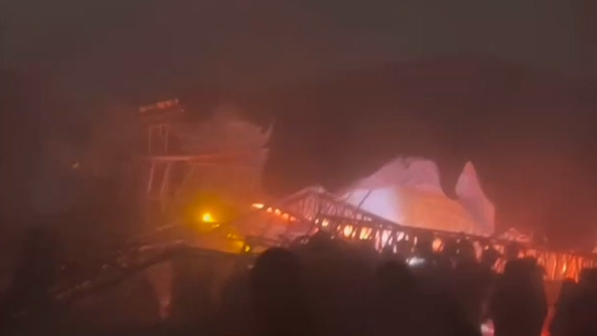
Pembroke, NC

8:59 PM EDT on May 20, 2013 (GMT -0400)
Elev: 167 ft
Lon: 79.2° W
Lat: 34.7° N
Source
Rapid Fire Updates™
Updated 8:52 PM EDT Get Free Weather Stickers® Share:
Your Custom Weather Sticker®

Copy the following lines of HTML:
News
May 20, 2013
Several children have been pulled out of the rubble alive at a school in an Oklahoma City suburb.
May 20, 2013
Homeland Security Secretary Janet Napolitano is assuring Oklahoma's governor that the Obama administration will provide all possible help to the state after a massive tornado tore through the Oklahoma City suburbs.
May 20, 2013
A monstrous tornado as much as a mile wide roared through the Oklahoma City suburbs Monday, flattening entire neighborhoods, setting buildings on fire and landing a direct blow on an elementary school.
May 20, 2013
Catastrophic tornadoes developed in Oklahoma on Monday. Here are photos and social media reports.
May 20, 2013
The moon has a new hole on its surface thanks to a boulder that slammed into it in March, creating the biggest explosion scientists have seen on the moon since they started monitoring it.
May 20, 2013
Chinese authorities say rainstorms that battered southern China this week have killed 55 people and left 14 others missing.
May 20, 2013
A tornado outbreak struck the Plains states on May 19, 2013, leaving widespread damage in its wake.
May 20, 2013
The weather imagery, video and recap from tornadoes in the Plains on May 19, 2013.
May 20, 2013
These stunning images of nature captured across the globe will change the way you view our world.
May 20, 2013
Photos and social media reports of severe weather damage over the weekend in Oklahoma, Iowa and Kansas.
May 20, 2013
Continuing coverage of destructive severe weather.
May 19, 2013
A tornado kicked up debris in an Oklahoma City suburb and threatened a number of tourist attractions on historic Route 66 but there were no immediate reports of injuries or major damage.
May 19, 2013
State emergency officials are monitoring a tornado in the Wichita area.
May 20, 2013
The latest breaking news, tornado warnings, photos and more.
May 19, 2013
Mice and other critters return from a month long stay in space.
May 20, 2013
Some locations have seen 5 to 6 inches of rainfall.
May 19, 2013
See the tornado, damaging wind and large hail reports on our interactive map.
May 19, 2013
See images and video from the Plains as severe thunderstorms left their mark.
May 19, 2013
Parts of the Plains, Midwest have seen a startling absence of tornadoes.
May 18, 2013
More than five dozens climbers successfully scaled Mount Everest.
Weather Summary
Weather Underground midday recap for Monday, May 20, 2013.

Heavy rains and chances of severe thunderstorm activity continued for areas of the Plains into the Midwest on Tuesday as a broad, nearly stationary low remained over the Northern Plains. As the system lingered, ample moisture streamed northward from the Gulf of Mexico, while an associated cold front reached from the low southward through Central and Southern Plains. The sharpening cold front combined with a dry line in the Southern Plains and the moisture laden conditions of the Central U.S. set the stage for multiple clusters of thunderstorms to develop across the Plains and into the Mid-Mississippi Valley. Portions of eastern/central Oklahoma, north-central Texas, northwestern Arkansas, southern Missouri, far southeastern Kansas remained at moderate risk of severe thunderstorm activity as environmental conditions remained favorable for strong tornadoes, damaging wind gusts, and very large hail. Areas surrounding this moderate risk region from the parts of the central Texas into the Upper Great Lakes and Upper Mississippi Valley were at slight risk of severe thunderstorm development with hail and isolated tornadoes.

Meanwhile, areas of heavy rain and widely scattered showers persisted near the low and it\\\\'s associated warm front in portions of the north-central U.S. Continued precipitation in this already saturate region combined with rapid runoff maintained flood concerns from parts of North Dakota into northwestern Wisconsin.

Elsewhere, scattered showers and thunderstorms developed in the Mid-Atlantic and southeastern corner of the nation as a weak upper trough of low pressure dropped southward over the region. To the north, additional showers were possible in the Northeast.

Pembroke Weather at a Glance

Updated 8:52 PM EDT
Weather Station
Elevation
220 ft
Report Station
You are about to report this weather station for bad data.

Please select the information which is incorrect and click 'Submit' otherwise click 'Cancel'.

Cancel

Now
Scattered Clouds
Scattered Clouds
Temperature
69 °F
Feels Like 69 °F
Wind(mph)
4
Sunrise / Set
6:10 AM
8:16 PM
Moon
Waxing Gibbous
Tonight
Thunderstorm 66 °F
T-storms
60% chance of precipitation
Tomorrow
Chance of a Thunderstorm 84 °F
Chance of T-storms
30% chance of precipitation
Tomorrow Night
Chance of a Thunderstorm 64 °F
Chance of T-storms
30% chance of precipitation
Wednesday
Chance of a Thunderstorm 84 | 64 °F
Chance of T-storms
30% chance of precipitation
Thursday
Chance of a Thunderstorm 84 | 64 °F
Chance of T-storms
40% chance of precipitation
Friday
Chance of a Thunderstorm 84 | 63 °F
Chance of a Thunderstorm
20% chance of precipitation
Tomorrow is forecast to be Warmer than today.
Conditions
Pressure
30.05 in
Visibility
10.0 miles
Clouds
Scattered Clouds 1500 ft
Moisture
Humidity
96%
Rainfall
0.01 in
Snow Depth
Not available.
METAR
METAR KMEB 210052Z AUTO 16003KT 10SM SCT015 21/20 A3006 RMK AO2 SLP176 T02060200 $
Don't speak METAR? Read our FAQ.
Weather Radio
Temperature
Temperature
69 °F
73,72,73,72,73,73,72,72,72,72,70,70,70
Dew Point
68 °F
Wind
Speed / Dir
4 mph from SSE
Wind Gust
Health
0 out of 16
Pollen
4.00 out of 12
Pollen Forecast
Ozone
Good
PM2.5
Good
Flu Activity
Sporadic
View Flu Map
Loading…
Source: BestForecast
Descriptive Forecast
Monday Night
nt_tstorms Mostly cloudy with thunderstorms and rain showers, then a chance of rain after midnight. Low of 66F. Winds from the SSW at 5 to 10 mph. Chance of rain 60%.
Tuesday
chancetstorms Partly cloudy with a chance of rain, then a chance of a thunderstorm and a chance of rain in the afternoon. High of 84F. Winds from the SSW at 5 to 10 mph. Chance of rain 30%.
Tuesday Night
nt_chancetstorms Partly cloudy with a chance of a thunderstorm and a chance of rain. Low of 64F. Winds from the SSW at 5 to 10 mph. Chance of rain 30%.
Wednesday
chancetstorms Partly cloudy in the morning, then clear with a chance of a thunderstorm and a chance of rain. High of 84F. Winds from the South at 5 to 10 mph. Chance of rain 30%.
Wednesday Night
nt_partlycloudy Clear with a chance of a thunderstorm and a chance of rain. Low of 64F. Winds from the South at 5 to 10 mph.
Thursday
chancetstorms Mostly cloudy with a chance of a thunderstorm and rain in the afternoon. High of 84F. Winds from the SSW at 5 to 10 mph. Chance of rain 40%.
Thursday Night
nt_chancetstorms Mostly cloudy with a chance of a thunderstorm and rain. Low of 64F. Winds from the SSW at 5 to 10 mph shifting to the West after midnight. Chance of rain 70% with rainfall amounts near 0.3 in. possible.
Friday
clear Clear with a chance of rain in the afternoon. High of 84F. Winds from the North at 10 to 15 mph. Chance of rain 20%.
Friday Night
nt_partlycloudy Clear. Low of 63F. Winds from the NE at 5 to 10 mph.
Saturday
partlycloudy Partly cloudy. High of 79F. Winds from the NE at 5 to 10 mph.
Saturday Night
nt_clear Clear. Low of 57F. Winds from the East at 5 to 10 mph.
Sunday
partlycloudy Partly cloudy. High of 81F. Winds less than 5 mph.
Sunday Night
nt_partlycloudy Partly cloudy. Low of 59F. Winds from the SSE at 5 to 10 mph.
Monday
partlycloudy Partly cloudy. High of 77F. Winds less than 5 mph.
Monday Night
nt_partlycloudy Partly cloudy. Low of 61F. Winds from the SSE at 5 to 10 mph.
Tuesday
partlycloudy Partly cloudy with a chance of a thunderstorm. High of 79F. Winds less than 5 mph. Chance of rain 20%.
Tuesday Night
nt_partlycloudy Partly cloudy. Low of 64F. Winds from the South at 5 to 10 mph.
Wednesday
chancetstorms Partly cloudy with a chance of a thunderstorm. High of 88F. Winds less than 5 mph. Chance of rain 50%.
Wednesday Night
nt_chancetstorms Partly cloudy with a chance of a thunderstorm. Low of 68F. Winds less than 5 mph. Chance of rain 50%.
Thursday
chancetstorms Partly cloudy with a chance of a thunderstorm. High of 90F. Winds less than 5 mph. Chance of rain 50%.
Thursday Night
nt_partlycloudy Partly cloudy. Low of 72F. Winds from the SSW at 5 to 10 mph.
Friday
partlycloudy Clear. High of 86F. Winds less than 5 mph.
Friday Night
nt_clear Clear. Low of 72F. Winds less than 5 mph.
Loading…
 
First Previous Last Next  
Updated:  


Weather Forecast for Pembroke NC

View Calendar 10-Day Forecast for station KMEB

Monday, 20
Thunderstorm
81 | 66 °F
T-storms
Chance of
Precipitation
60%
Tuesday, 21
Chance of a Thunderstorm
84 | 64 °F
Chance of T-storms
Chance of
Precipitation
30%
Wednesday, 22
Chance of a Thunderstorm
84 | 64 °F
Chance of T-storms
Chance of
Precipitation
30%
Thursday, 23
Chance of a Thunderstorm
84 | 64 °F
Chance of T-storms
Chance of
Precipitation
40%
Friday, 24
Chance of a Thunderstorm
84 | 63 °F
Chance of a Thunderstorm
Chance of
Precipitation
20%
Saturday, 25
Partly Cloudy
79 | 57 °F
Partly Cloudy
Chance of
Precipitation
0%
Sunday, 26
Partly Cloudy
81 | 59 °F
Partly Cloudy
Chance of
Precipitation
0%
Monday, 27
Partly Cloudy
77 | 61 °F
Partly Cloudy
Chance of
Precipitation
0%
Tuesday, 28
Chance of a Thunderstorm
79 | 64 °F
Chance of a Thunderstorm
Chance of
Precipitation
20%
Wednesday, 29
Chance of a Thunderstorm
88 | 68 °F
Chance of T-storms
Chance of
Precipitation
50%
Source: BestForecast at 3:48 PM EDT on May 20, 2013
Descriptive Forecast
Monday Night
nt_tstorms Mostly cloudy with thunderstorms and rain showers, then a chance of rain after midnight. Low of 66F. Winds from the SSW at 5 to 10 mph. Chance of rain 60%.
Hourly Forecast 6AM 12 Noon 6PM 12 Midnight
Temp. | Dew Point 66 | 65 75 | 66 76 | 66 66 | 65
Wind 7 mph South 9 mph SSW 8 mph SSW 6 mph SSW
Humidity 95% 74% 72% 96%
Chance of Precip. 80% 90% 60% 60%
Cloud Cover 92% 89% 69% 61%
Conditions Chance of Rain Thunderstorm Thunderstorm Thunderstorm
Sunrise & Sunset
6:10 AM
8:16 PM
The quality of the forecasted high temperature for this day is excellent. MaxT RMSE [1.11], Average RMSE [1.74]
The National Weather Service forecast quality is excellent. MaxT RMSE [1.41], Average RMSE [1.85] : Use NWS
Source: BestForecast at 3:48 PM EDT on May 20, 2013
Descriptive Forecast
Tuesday
chancetstorms Partly cloudy with a chance of rain, then a chance of a thunderstorm and a chance of rain in the afternoon. High of 84F. Winds from the SSW at 5 to 10 mph. Chance of rain 30%.
Tuesday Night
nt_chancetstorms Partly cloudy with a chance of a thunderstorm and a chance of rain. Low of 64F. Winds from the SSW at 5 to 10 mph. Chance of rain 30%.
Hourly Forecast 6AM 12 Noon 6PM 12 Midnight
Temp. | Dew Point 69 | 65 79 | 67 79 | 66 67 | 65
Wind 5 mph SSW 7 mph SSW 7 mph SSW 7 mph South
Humidity 91% 68% 62% 91%
Chance of Precip. 60% 40% 30% 10%
Cloud Cover 75% 76% 22% 72%
Conditions Chance of Rain Chance of Rain Chance of a Thunderstorm Mostly Cloudy
Sunrise & Sunset
6:09 AM
8:17 PM
The quality of the forecasted high temperature for this day is good. MaxT RMSE [1.59], Average RMSE [1.85]
The National Weather Service forecast quality is good. MaxT RMSE [1.88], Average RMSE [1.72] : Use NWS
Source: BestForecast at 3:48 PM EDT on May 20, 2013
Descriptive Forecast
Wednesday
chancetstorms Partly cloudy in the morning, then clear with a chance of a thunderstorm and a chance of rain. High of 84F. Winds from the South at 5 to 10 mph. Chance of rain 30%.
Wednesday Night
nt_partlycloudy Clear with a chance of a thunderstorm and a chance of rain. Low of 64F. Winds from the South at 5 to 10 mph.
Hourly Forecast 6AM 12 Noon 6PM 12 Midnight
Temp. | Dew Point 68 | 66 79 | 65 78 | 63 69 | 67
Wind 6 mph SSW 8 mph South 9 mph South 8 mph South
Humidity 93% 62% 60% 94%
Chance of Precip. 10% 10% 30% 10%
Cloud Cover 62% 69% 17% 44%
Conditions Partly Cloudy Mostly Cloudy Chance of a Thunderstorm Partly Cloudy
Sunrise & Sunset
6:09 AM
8:18 PM
The quality of the forecasted high temperature for this day is good. MaxT RMSE [2.13], Average RMSE [1.81]
The National Weather Service forecast quality is good. MaxT RMSE [1.95], Average RMSE [2.13] : Use NWS
Source: BestForecast at 3:48 PM EDT on May 20, 2013
Descriptive Forecast
Thursday
chancetstorms Mostly cloudy with a chance of a thunderstorm and rain in the afternoon. High of 84F. Winds from the SSW at 5 to 10 mph. Chance of rain 40%.
Thursday Night
nt_chancetstorms Mostly cloudy with a chance of a thunderstorm and rain. Low of 64F. Winds from the SSW at 5 to 10 mph shifting to the West after midnight. Chance of rain 70% with rainfall amounts near 0.3 in. possible.
Hourly Forecast 6AM 12 Noon 6PM 12 Midnight
Temp. | Dew Point 69 | 67 80 | 70 82 | 70 72 | 67
Wind 6 mph South 7 mph SSW 6 mph SW 7 mph SSW
Humidity 93% 69% 67% 88%
Chance of Precip. 0% 0% 30% 30%
Cloud Cover 84% 82% 52% 49%
Conditions Mostly Cloudy Mostly Cloudy Chance of a Thunderstorm Chance of a Thunderstorm
Sunrise & Sunset
6:08 AM
8:18 PM
The quality of the forecasted high temperature for this day is good. MaxT RMSE [2.09], Average RMSE [1.68]
The National Weather Service forecast quality is good. MaxT RMSE [2.37], Average RMSE [2.33] : Use NWS
Source: BestForecast at 3:48 PM EDT on May 20, 2013
Descriptive Forecast
Friday
clear Clear with a chance of rain in the afternoon. High of 84F. Winds from the North at 10 to 15 mph. Chance of rain 20%.
Friday Night
nt_partlycloudy Clear. Low of 63F. Winds from the NE at 5 to 10 mph.
Hourly Forecast 6AM 12 Noon 6PM 12 Midnight
Temp. | Dew Point 64 | 64 77 | 61 74 | 60 67 | 53
Wind 7 mph NW 12 mph NNW 10 mph NNE 6 mph NE
Humidity 94% 56% 62% 62%
Chance of Precip. 20% 10% 20% 10%
Cloud Cover 33% 17% 4% 29%
Conditions Chance of a Thunderstorm Clear Chance of Rain Partly Cloudy
Sunrise & Sunset
6:08 AM
8:19 PM
The quality of the forecasted high temperature for this day is good. MaxT RMSE [2.25], Average RMSE [1.74]
The National Weather Service forecast quality is good. MaxT RMSE [2.23], Average RMSE [2.56] : Use NWS
Source: BestForecast at 3:48 PM EDT on May 20, 2013
Descriptive Forecast
Saturday
partlycloudy Partly cloudy. High of 79F. Winds from the NE at 5 to 10 mph.
Saturday Night
nt_clear Clear. Low of 57F. Winds from the East at 5 to 10 mph.
Hourly Forecast 6AM 12 Noon 6PM 12 Midnight
Temp. | Dew Point 63 | 47 71 | 46 74 | 49 64 | 45
Wind 8 mph NNE 8 mph NE 5 mph NE 6 mph ESE
Humidity 57% 40% 39% 49%
Chance of Precip. 0% 0% 0% 0%
Cloud Cover 33% 35% 46% 26%
Conditions Partly Cloudy Partly Cloudy Partly Cloudy Partly Cloudy
Sunrise & Sunset
6:07 AM
8:20 PM
The quality of the forecasted high temperature for this day is fair. MaxT RMSE [2.64], Average RMSE [2.28]
The National Weather Service forecast quality is good. MaxT RMSE [2.48], Average RMSE [2.60] : Use NWS
Source: BestForecast at 3:48 PM EDT on May 20, 2013
Descriptive Forecast
Sunday
partlycloudy Partly cloudy. High of 81F. Winds less than 5 mph.
Sunday Night
nt_partlycloudy Partly cloudy. Low of 59F. Winds from the SSE at 5 to 10 mph.
Hourly Forecast 6AM 12 Noon 6PM 12 Midnight
Temp. | Dew Point 58 | 43 74 | 48 73 | 52 59 | 51
Wind 5 mph East 4 mph ESE 5 mph SE 7 mph SSE
Humidity 55% 40% 46% 73%
Chance of Precip. 0% 0% 0% 0%
Cloud Cover 14% 63% 35% 47%
Conditions Clear Partly Cloudy Partly Cloudy Partly Cloudy
Sunrise & Sunset
6:07 AM
8:20 PM
The quality of the forecasted high temperature for this day is poor. MaxT RMSE [4.76], Average RMSE [2.64]
The National Weather Service forecast quality is fair. MaxT RMSE [2.83], Average RMSE [2.73] : Use NWS
Source: BestForecast at 3:48 PM EDT on May 20, 2013
Descriptive Forecast
Monday
partlycloudy Partly cloudy. High of 77F. Winds less than 5 mph.
Monday Night
nt_partlycloudy Partly cloudy. Low of 61F. Winds from the SSE at 5 to 10 mph.
Hourly Forecast 6AM 12 Noon 6PM 12 Midnight
Temp. | Dew Point 60 | 53 72 | 56 75 | 59 64 | 56
Wind 4 mph SSE 5 mph SSE 3 mph SE 7 mph SSE
Humidity 75% 56% 57% 75%
Chance of Precip. 0% 0% 10% 0%
Cloud Cover 23% 66% 60% 76%
Conditions Clear Mostly Cloudy Partly Cloudy Mostly Cloudy
Sunrise & Sunset
6:06 AM
8:21 PM
The quality of the forecasted high temperature for this day is poor. MaxT RMSE [5.69], Average RMSE [3.16]
Source: BestForecast at 3:48 PM EDT on May 20, 2013
Descriptive Forecast
Tuesday
partlycloudy Partly cloudy with a chance of a thunderstorm. High of 79F. Winds less than 5 mph. Chance of rain 20%.
Tuesday Night
nt_partlycloudy Partly cloudy. Low of 64F. Winds from the South at 5 to 10 mph.
Hourly Forecast 6AM 12 Noon 6PM 12 Midnight
Temp. | Dew Point 63 | 56 74 | 60 74 | 63 67 | 63
Wind 4 mph SSE 3 mph SSE 5 mph SSE 5 mph SSE
Humidity 74% 57% 67% 85%
Chance of Precip. 10% 0% 10% 10%
Cloud Cover 83% 60% 25% 60%
Conditions Mostly Cloudy Partly Cloudy Clear Partly Cloudy
Sunrise & Sunset
6:06 AM
8:22 PM
The quality of the forecasted high temperature for this day is poor. MaxT RMSE [4.59], Average RMSE [4.24]
Source: BestForecast at 3:48 PM EDT on May 20, 2013
Descriptive Forecast
Wednesday
chancetstorms Partly cloudy with a chance of a thunderstorm. High of 88F. Winds less than 5 mph. Chance of rain 50%.
Wednesday Night
nt_chancetstorms Partly cloudy with a chance of a thunderstorm. Low of 68F. Winds less than 5 mph. Chance of rain 50%.
Hourly Forecast 6AM 12 Noon 6PM 12 Midnight
Temp. | Dew Point 67 | 61 77 | 63 86 | 67 70 | 67
Wind 3 mph South 3 mph SSW 4 mph South 4 mph South
Humidity 81% 60% 54% 90%
Chance of Precip. 0% 10% 10% 10%
Cloud Cover 43% 38% 36% 40%
Conditions Partly Cloudy Partly Cloudy Partly Cloudy Partly Cloudy
Sunrise & Sunset
6:05 AM
8:22 PM
Source: BestForecast at 3:48 PM EDT on May 20, 2013
Descriptive Forecast
Thursday
chancetstorms Partly cloudy with a chance of a thunderstorm. High of 90F. Winds less than 5 mph. Chance of rain 50%.
Thursday Night
nt_partlycloudy Partly cloudy. Low of 72F. Winds from the SSW at 5 to 10 mph.
Hourly Forecast 6AM 12 Noon 6PM 12 Midnight
Temp. | Dew Point 69 | 65 81 | 67 88 | 69 73 | 67
Wind 3 mph SSW 3 mph SSW 5 mph South 6 mph South
Humidity 88% 62% 53% 85%
Chance of Precip. 10% 10% 10% 10%
Cloud Cover 49% 51% 45% 42%
Conditions Partly Cloudy Partly Cloudy Partly Cloudy Partly Cloudy
Sunrise & Sunset
Sun does not rise
Source: BestForecast at 3:48 PM EDT on May 20, 2013
Descriptive Forecast
Friday
partlycloudy Clear. High of 86F. Winds less than 5 mph.
Friday Night
nt_clear Clear. Low of 72F. Winds less than 5 mph.
Hourly Forecast 6AM 12 Noon 6PM 12 Midnight
Temp. | Dew Point 72 | 65 81 | 65 80 | 66 69 | 65
Wind 5 mph SSW 4 mph SW 5 mph SSW 5 mph ESE
Humidity 80% 56% 62% 85%
Chance of Precip. 0% 0% 0% 0%
Cloud Cover 43% % % %
Conditions Partly Cloudy Clear Clear Clear
Sunrise & Sunset
Sun does not rise
Nearby
Active Notice: Record Report  (US Severe Weather)
History & Almanac
May 20, 2013 Max Temp Min Temp
Normal (KLBT) 83 °F 59 °F
Record (KLBT) 98 °F (2000) 42 °F (2002)
Yesterday 84 °F 68 °F
Yesterday's Cooling Degree Days: 11
Choose a date
Earthquake Activity
City Distance Mag. Time & Date
No recent earthquake activity has been reported nearby.
Minimum magnitude displayed is 2.5.
Air Quality
  Air Quality AQ Index Pollutant
Yesterday Good
OZONE
Yesterday Good
PM2.5
Current Good
OZONE
Current Good
PM2.5
Monday Good
PM2.5
Monday Good
OZONE
Tuesday Good
OZONE
Tuesday Good
PM2.5
Wednesday Good
PM2.5
Wednesday Good
OZONE
Thursday Good
PM2.5
Thursday Good
OZONE
Astronomy
May. 20, 2013 Rise Set
Actual Time 6:10 AM EDT 8:16 PM EDT
Civil Twilight 5:42 AM EDT 8:45 PM EDT
Nautical Twilight 5:07 AM EDT 9:19 PM EDT
Astronomical Twilight 4:30 AM EDT 9:56 PM EDT
Moon 3:33 PM EDT (5/20) 2:52 AM EDT (5/20)
Length Of Visible Light 15h 03m
Length of Day
14h 06m
Tomorrow will be 1m 21s longer.
Waxing Gibbous, 78% of the Moon is Illuminated
Today
Waxing Gibbous
May 25
Full
May 31
Last Quarter
Jun 8
New
Jun 16
First Quarter
Today's Extremes
State Highs State Lows
83 °F
Andrews
82 °F
Charlotte
82 °F
Jacksonville
82 °F
Concord
53 °F
Andrews
56 °F
Franklin
59 °F
Jefferson
60 °F
Asheville
Snow Depth
Station Depth Elevation
No new snow has been reported.
WunderPhotos®
Robertson River
Today's rays of the sun before the sunset!
Uploaded by: katy99780
1,613,389 photos uploaded!
WunderBlogs®

There are no recent blogs in this area. Why not create your own?

Travel & Activities
Travel Planning
Destination? *
When are you going?
to
Is there an activity you would like to explore?
* Required field
Aviation
City Temp. Conditions Updated
Lumberton 70 °F Mostly Cloudy 8:54 PM EDT
Laurinburg-Maxton 69 °F Scattered Clouds 8:52 PM EDT
Fayetteville 71 °F Clear 8:53 PM EDT
Mackall AAF 71 °F Overcast 8:56 PM EDT
Flight To ETA Status
No flights were found.
Flight Tracker by FlightAware FlightAware
Type Condition
Flight Rule: VFR (KMEB)
Wind Speed: 3.0 kts.
Wind Dir: 160° (SSE)
Ceiling: Unlimited

METAR KMEB 210052Z AUTO 16003KT 10SM SCT015 21/20 A3006 RMK AO2 SLP176 T02060200 $

Nearby Events
Event Date Forecast
No events within 10 mi of location. View all events.
Event data courtesy eviesays.com
Sports
Event Date Forecast
Yankees vs. Orioles 7:05 PM EDT on May 20, 2013 Partly Cloudy, 79 °F
Twins vs. Braves 7:10 PM EDT on May 20, 2013 Partly Cloudy, 81 °F
Event Date Forecast
Murcia vs. Guadalajara 3:00 PM EDT on May 20, 2013 Forecast not available.
Betis vs. Mallorca 10:00 PM CEST on May 20, 2013 Partly Cloudy, High 71° F/ 22° C
Event Date Forecast
Coca-Cola 600 6:16 PM EDT on May 26, 2013 Chance of Rain, 70 °F
FedEx 400 benefiting Autism Speaks 1:15 PM EDT on June 02, 2013 Average High 81° F/ 27° C
Event Date Forecast
Crowne Plaza Invitational at Colonial 8:30 AM CDT on May 23, 2013 Partly Cloudy, 68 °F
Crowne Plaza Invitational at Colonial 8:30 AM CDT on May 24, 2013 Partly Cloudy, 68 °F
Videos
Year In Weather 2012

Watch the nearly year-long satellite animation as Weather Underground calls out the most significant weather events of the past year, including Superstorm Sandy and Hurricane Isaac.

Weather Stations
Station Location Temp. Heat Index Dew Point Humidity Wind Precipitation Elevation Updated Type Website
Fayetteville Road, Lumberton, NC 70.9 °F - 70 °F 98% ESE  at  0.0 mph 0.00 in / hr 126 ft 8:59 PM EDT Rapid Fire  
Timberland , Western Hoke Co NC, Raeford, NC 69.3 °F - 67 °F 92% SSW  at  0.0 mph - / hr 0 ft 8:59 PM EDT Rapid Fire
Town of Tar Heel, Tar Heel, NC 72.5 °F 72 °F 67 °F 83% SW  at  0.7 mph 0.00 in / hr 125 ft 8:09 PM EDT Rapid Fire
MesoWest W58A Raeford , Raeford, NC 71 °F - 67 °F 86% South  at  5 mph 0.00 in / hr 274 ft 8:15 PM EDT MADIS
Gates Four, Fayetteville, NC 70.7 °F - 69 °F 95% South  at  1.0 mph 0.00 in / hr 190 ft 8:55 PM EDT Normal  
Would you like to share your weather data with the rest of the world? Add Your Weather Station!
Record Report
Mobile & Email Alerts Statement as of 04:44 am EDT on May 20, 2013

... Record daily maximum rainfall set at Florence SC...

A record rainfall of 1.38 inches was set at Florence SC yesterday.
This breaks the old record of 0.91 set in 1960.