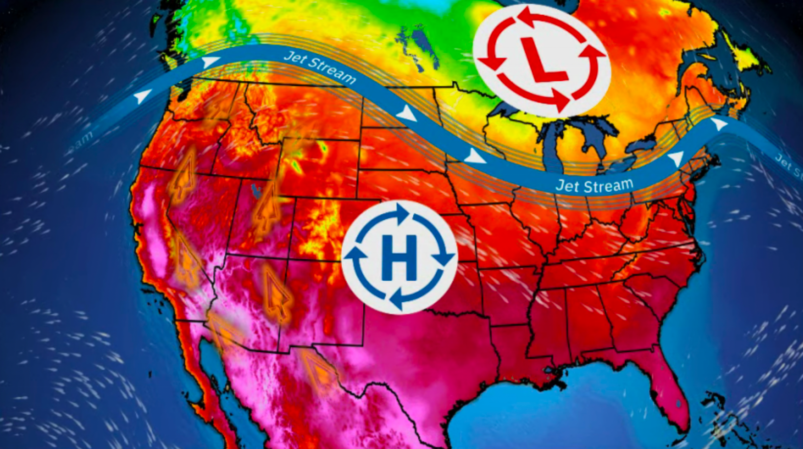
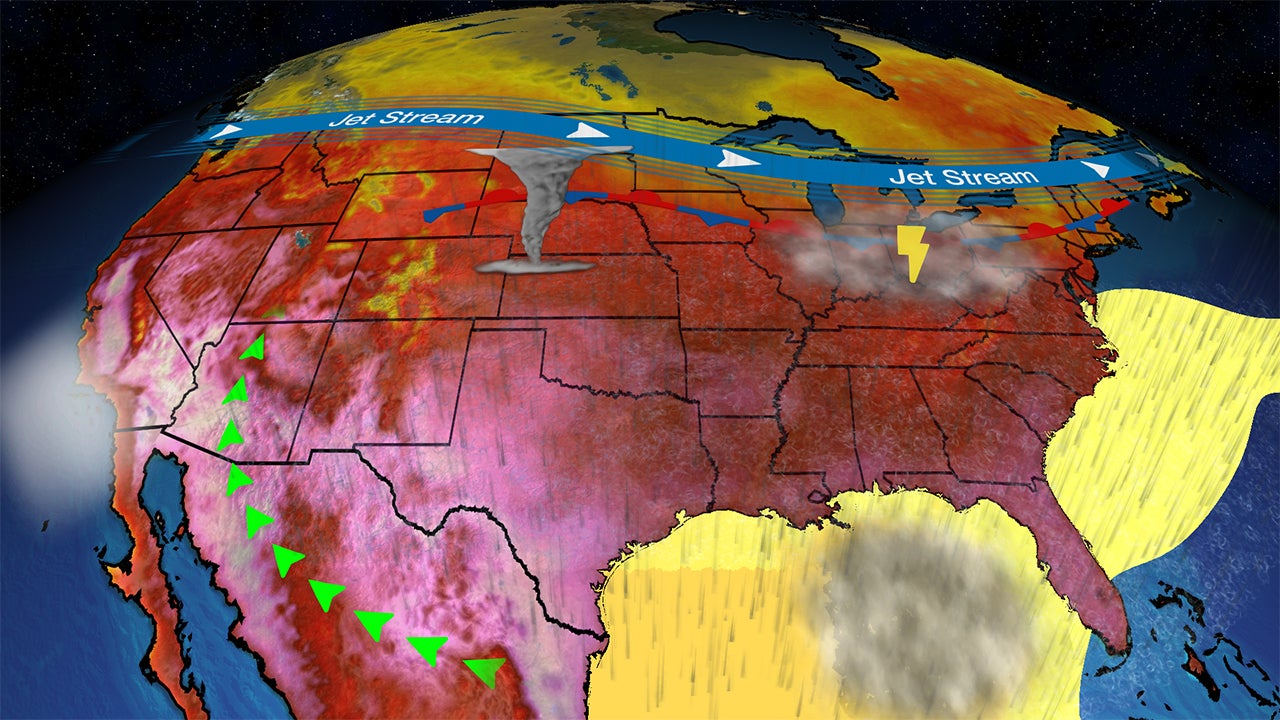
Blaine, MN

11:15 AM CST on February 11, 2012 (GMT -0600)
Elev: 899 ft
Lon: 93.1° W
Lat: 45.2° N
Rapid Fire Updates™ Updated 11:15 AM CST Make this Location a Weather Sticker® Share:
Your Custom Weather Sticker®

Copy the following lines of HTML:
Tropical Weather: Tropical Cyclone Giovanna (South Indian Ocean) Tropical Cyclone Jasmine (Southern Pacific)
Weather Summary
Weather Underground Forecast for Saturday, February 11, 2012.

Precipitation will spread across the East Coast on Saturday, while more rain and mountain snow showers are anticipated for parts of the West. A trough of low pressure and associated cold front continue moving eastward across the Eastern Valleys into the Eastern Seaboard. Cool temperatures to the north will allow for snow showers to develop across the Northeast and New England, while rain showers are likely over the Mid-Atlantic states. Rain showers over the Southeastern states should wind down in the early morning hours as the tail end of the system pushes offshore early in the day. Expect the New York metropolitan area to see 1 to 3 inches of snow, while the Washington D.C. area will see a messy combination of snow and freezing rain as high temperatures reach into the lower 40s.

Behind this system, a ridge of high pressure continues to build in from the Plains, pushing cold and dry air in from Canada. This allows for plenty of sunshine to spread from the Plains over the Mississippi River Valley and into the Eastern Valleys. Expect the Northern Plains and Upper Midwest to see highs in the teens again, while the Midwest will see highs in the 20s. Strong winds will accompany this system, pushing windchill values below zero in these areas. The Southern Plains will remain in the 40s on Saturday.

Out West, a trough of low pressure pushes a cold front over the Pacific Northwest and continues pulling moisture onshore with it. This will kick up more rain showers with high elevation snow showers likely in the Cascades. The tail end of the frontal boundary will sweep through California, bringing light rain showers to the coasts and interior valleys. Expect light snow showers in the Sierra Nevadas by Saturday evening.
Blaine Weather at a Glance
Updated 11:15 AM CST
Weather Station - report
Elevation
902 ft
Report Station
You are about to report this weather station for bad data.

Please select the information which is incorrect and click 'Submit' otherwise click 'Cancel'.

Cancel

Now
Clear
Clear
Temperature
12.6 °F
Feels Like 6 °F
Wind(mph)
4.0
Sunrise / Set
7:20 AM
5:33 PM
Moon
Waning Gibbous
Today
Clear 14 °F
Clear
Tonight
Clear 2 °F
Clear
Tomorrow
Clear 25 | 14 °F
Clear
Monday
Chance of Snow 31 | 22 °F
Chance of Snow
20% chance of precipitation
Tuesday
Partly Cloudy 34 | 23 °F
Partly Cloudy
Wednesday
Partly Cloudy 36 | 23 °F
Partly Cloudy
Today is forecast to be nearly the same temperature as yesterday.
Conditions
Pressure
30.55 in
Visibility
10.0 miles
Clouds
Clear -
Moisture
Humidity
44%
Rainfall
0.00 in
Snow Depth
Not available.
METAR
METAR KANE 111445Z 30013G19KT 10SM SKC M15/M23 A3058
Don't speak METAR? Read our FAQ.
Weather Radio
Temperature
Windchill
6 °F
Dew Point
-5 °F
Wind
Speed / Dir
4.0 mph from NNW
Wind Gust
10.9 mph
Health
UV
1 out of 16
Pollen
.10 out of 12
Pollen Forecast
Ozone
Good
PM2.5
Good
Flu Activity
Local Activity
View Flu Map
Loading…
Regional Forecast for Anoka
Today
sunny Sunny. Highs around 15. Northwest winds 10 to 20 mph.
Tonight
nt_sunny Clear. Lows zero to 5 above zero. West winds 5 to 15 mph.
Sunday
sunny Sunny. Highs around 25. West winds 5 to 15 mph.
Sunday Night
nt_sunny Not as cold. Clear. Lows around 15. South winds 10 mph.
Monday
chancesnow Partly cloudy in the morning...then mostly cloudy with a 20 percent chance of snow in the afternoon. Highs around 30. South winds 5 to 10 mph.
Monday Night
nt_chancesnow Mostly cloudy. A 20 percent chance of snow in the evening. Lows 20 to 25.
Tuesday through Wednesday Night
partlycloudy Partly cloudy. Highs around 35. Lows around 25.
Thursday and Thursday Night
nt_partlycloudy Partly cloudy. Highs around 40. Lows 20 to 25.
Friday
partlycloudy Partly cloudy. Highs around 35.
Source: NWS at 3:30 am CST on February 11, 2012
Loading…
 
First Previous Last Next  
Updated:  


webcam preview
Forecast
View Calendar 7-Day Weather Forecast for 55014
Saturday, 11
Clear
14 | 2 °F
Clear
Chance of
Precipitation
0%
Sunday, 12
Clear
25 | 14 °F
Clear
Chance of
Precipitation
0%
Monday, 13
Chance of Snow
31 | 22 °F
Chance of Snow
Chance of
Precipitation
20%
Tuesday, 14
Partly Cloudy
34 | 23 °F
Partly Cloudy
Chance of
Precipitation
0%
Wednesday, 15
Partly Cloudy
36 | 23 °F
Partly Cloudy
Chance of
Precipitation
0%
Thursday, 16
Partly Cloudy
38 | 22 °F
Partly Cloudy
Chance of
Precipitation
10%
Friday, 17
Partly Cloudy
36 | NA
Partly Cloudy
Chance of
Precipitation
10%
Source: NWS at 3:30 am CST on February 11, 2012
Regional Forecast for Anoka
Today
sunny Sunny. Highs around 15. Northwest winds 10 to 20 mph.
Tonight
nt_sunny Clear. Lows zero to 5 above zero. West winds 5 to 15 mph.
Hourly Forecast 6AM 12 Noon 6PM 12 Midnight
Temp. | Dew Point 0 | -9 11 | -12 11 | 0 7 | -5
Wind 7 mph NW 14 mph WNW 12 mph WNW 11 mph WNW
Humidity 64% 32% 52% 51%
Chance of Precip. 0% 0% 0% 0%
Cloud Cover 7% 7% 8% 6%
Conditions Clear Clear Clear Clear
Sunrise & Sunset
7:20 AM
5:33 PM
Source: NWS at 3:30 am CST on February 11, 2012
Regional Forecast for Anoka
Sunday
sunny Sunny. Highs around 25. West winds 5 to 15 mph.
Sunday Night
nt_sunny Not as cold. Clear. Lows around 15. South winds 10 mph.
Hourly Forecast 6AM 12 Noon 6PM 12 Midnight
Temp. | Dew Point 4 | -3 20 | 0 20 | 0 16 | -3
Wind 9 mph West 8 mph West 5 mph WSW 5 mph SSW
Humidity 65% 35% 40% 38%
Chance of Precip. 0% 0% 0% 0%
Cloud Cover 3% 2% 4% 6%
Conditions Clear Clear Clear Clear
Sunrise & Sunset
7:18 AM
5:35 PM
Source: NWS at 3:30 am CST on February 11, 2012
Regional Forecast for Anoka
Monday
chancesnow Partly cloudy in the morning...then mostly cloudy with a 20 percent chance of snow in the afternoon. Highs around 30. South winds 5 to 10 mph.
Monday Night
nt_chancesnow Mostly cloudy. A 20 percent chance of snow in the evening. Lows 20 to 25.
Hourly Forecast 6AM 12 Noon 6PM 12 Midnight
Temp. | Dew Point 14 | 2 25 | 11 27 | 22 25 | 22
Wind 4 mph South 6 mph South 4 mph South 2 mph SSW
Humidity 58% 54% 81% 92%
Chance of Precip. 0% 20% 20% 10%
Cloud Cover 40% 70% 94% 90%
Conditions Partly Cloudy Chance of Snow Overcast Overcast
Sunrise & Sunset
7:17 AM
5:36 PM
Source: NWS at 3:30 am CST on February 11, 2012
Regional Forecast for Anoka
Tuesday through Wednesday Night
partlycloudy Partly cloudy. Highs around 35. Lows around 25.
Hourly Forecast 6AM 12 Noon 6PM 12 Midnight
Temp. | Dew Point 22 | 22 32 | 22 32 | 20 27 | 20
Wind 1 mph SW 4 mph SW 4 mph SW 2 mph SW
Humidity 91% 66% 61% 77%
Chance of Precip. 10% 0% 0% 0%
Cloud Cover 74% 50% 36% 38%
Conditions Mostly Cloudy Partly Cloudy Partly Cloudy Partly Cloudy
Sunrise & Sunset
7:15 AM
5:38 PM
Source: NWS at 3:30 am CST on February 11, 2012
Regional Forecast for Anoka
Tuesday through Wednesday Night
partlycloudy Partly cloudy. Highs around 35. Lows around 25.
Hourly Forecast 6AM 12 Noon 6PM 12 Midnight
Temp. | Dew Point 23 | 18 36 | 22 31 | 22 27 | 20
Wind 2 mph WSW 6 mph WSW 4 mph WSW 2 mph WSW
Humidity 80% 54% 66% 77%
Chance of Precip. 0% 10% 10% 10%
Cloud Cover 39% 39% 33% 41%
Conditions Partly Cloudy Partly Cloudy Partly Cloudy Partly Cloudy
Sunrise & Sunset
7:14 AM
5:39 PM
Source: NWS at 3:30 am CST on February 11, 2012
Regional Forecast for Anoka
Thursday and Thursday Night
nt_partlycloudy Partly cloudy. Highs around 40. Lows 20 to 25.
Hourly Forecast 6AM 12 Noon 6PM 12 Midnight
Temp. | Dew Point 25 | 20 36 | 22 32 | 20 25 | 18
Wind 1 mph West 6 mph WNW 6 mph WNW 4 mph NW
Humidity 81% 54% 60% 77%
Chance of Precip. 10% 10% 10% 10%
Cloud Cover 53% 49% 49% 40%
Conditions Partly Cloudy Partly Cloudy Partly Cloudy Partly Cloudy
Sunrise & Sunset
7:14 AM
5:39 PM
Source: NWS at 3:30 am CST on February 11, 2012
Regional Forecast for Anoka
Friday
partlycloudy Partly cloudy. Highs around 35.
Hourly Forecast 6AM 12 Noon 6PM 12 Midnight
Temp. | Dew Point 22 | 18 36 | 20 32 | 20 25 | 18
Wind 2 mph NW 1 mph WSW 6 mph WNW 4 mph NW
Humidity 80% 54% 60% 77%
Chance of Precip. 10% 10% 10% 10%
Cloud Cover 55% 50% 49% 40%
Conditions Partly Cloudy Partly Cloudy Partly Cloudy Partly Cloudy
Sunrise & Sunset
7:14 AM
5:39 PM
BestForecast (what's this?)
Nearby
History & Almanac
February 11, 2012 Max Temp Min Temp
Normal (KANE) 26 °F 11 °F
Record (KANE) 46 °F (2005) -9 °F (2011)
Yesterday 27.2 °F 5.5 °F
Choose a date
Earthquake Activity
City Distance Mag. Time & Date
No recent earthquake activity has been reported nearby.
Minimum magnitude displayed is 2.5.
Air Quality
  Air Quality AQ Index Pollutant
Yesterday Good
OZONE
Yesterday Good
PM10
Current Good
OZONE
Current Good
PM2.5
Saturday Good
PM2.5
Sunday Good
PM2.5
Monday Good
PM2.5
Tuesday Good
PM2.5
Wednesday Moderate
PM2.5
Astronomy
Feb. 11, 2012 Rise Set
Actual Time 7:20 AM CST 5:33 PM CST
Civil Twilight 6:49 AM CST 6:04 PM CST
Nautical Twilight 6:15 AM CST 6:39 PM CST
Astronomical Twilight 5:40 AM CST 7:13 PM CST
Moon 10:40 PM CST 8:47 AM CST
Length Of Visible Light 11h 14m
Length of Day
10h 13m
Tomorrow will be 2m 53s longer.
Waning Gibbous, 82% of the Moon is Illuminated
Today
Waning Gibbous
Feb 14
Last Quarter
Feb 21
New
Feb 29
First Quarter
Mar 8
Full
Today's Extremes
State Highs State Lows
8 °F
Preston
8 °F
Red Wing
8 °F
Winona
-14 °F
Crookston
-13 °F
Orr
-11 °F
Flag Island
-11 °F
Crane Lake
Source: NWS
Snow Depth
Station Depth Elevation
No new snow has been reported.
WunderPhotos®
Arctic Front Roars in
cyclone Ismet
Uploaded by: MichiganSnowLvr
1,456,494 photos uploaded!
WunderBlogs®
Another warm week ahead
By MNTornado 10 days ago
Travel & Activities
Travel Planning
Destination? *
When are you going?
to
Is there an activity you would like to explore?
* Required field
Aviation
City Temp. Conditions Updated
Anoka County 5 °F Clear 8:45 AM CST
Minneapolis Crystal 4 °F Clear 8:53 AM CST
St. Paul 5 °F Clear 8:53 AM CST
St. Paul Lake Elmo 3 °F Clear 8:55 AM CST
Flight To ETA Status
No flights were found.
Flight Tracker by FlightAware FlightAware
Type Condition
Flight Rule: VFR (KANE)
Wind Speed: 13.0 kts.
Wind Dir: 340° (NNW)
Ceiling: Unlimited

METAR KANE 111445Z 30013G19KT 10SM SKC M15/M23 A3058

Nearby Events
Event Date Forecast
Vegas Lounge Karaoke 9:00 PM CST 2012-02-11 Clear, 14°F
King Size Weekend 2012 7:00 PM CST 2012-02-11 Clear, 17°F
Uke Make Me Laugh Comedy Show 8:00 PM CST 2012-02-11 Clear, 15°F
Ruff Start Rescue - Sit Means Sit 10:00 AM CST 2012-02-11 Clear, 10°F
Vegas Lounge Karaoke 9:00 PM CST 2012-02-12 Clear, 21°F
GracePoint Life Application Project 2012 6:00 PM CST 2012-02-12 Clear, 25°F
Event data courtesy eviesays.com
Sports
Event Date Forecast
Budweiser Shootout 8:29 PM EST on February 18, 2012 Average High 71° F/ 21° C
Gatorade Duel 1 2:19 PM EST on February 23, 2012 Average High 70° F/ 21° C
Event Date Forecast
AT&T Pebble Beach National Pro-Am 8:30 AM PST on February 11, 2012 Rain Showers, 45 °F
AT&T Pebble Beach National Pro-Am 8:30 AM PST on February 12, 2012 Mostly Cloudy, 45 °F
Weather Stations
Station Location Temp. Windchill Dew Point Humidity Wind Precipitation Elevation Updated Type Website
"Rural" Blaine, Blaine, MN 12.6 °F 6 °F -5 °F 44% NNW  at  4.0 mph 0.00 in / hr 902 ft 11:15 AM CST Rapid Fire
Flowerfield Road, SE Blaine, MN 17.6 °F 18 °F -0 °F 45% WNW  at  2.2 mph 0.00 in / hr 889 ft 11:15 AM CST Rapid Fire  
Blaine, Blaine, MN 12.9 °F 2 °F 31 °F 27% NNW  at  8.0 mph - / hr 0 ft 11:14 AM CST Rapid Fire
Woods of Deer Creek, Ham Lake, MN 10.0 °F 10 °F -8 °F 44% SW  at  1.0 mph 0.00 in / hr 890 ft 11:07 AM CST Normal
Coon Rapids - Burl Oaks II, Coon Rapids, MN 10.0 °F - -13 °F 34% WNW  at  6.0 mph - / hr 890 ft 11:04 AM CST Normal  
Hy10, Coon Rapids, MN 10.0 °F -1 °F -7 °F 45% WNW  at  7.5 mph 0.00 in / hr 900 ft 11:14 AM CST Rapid Fire
Andar's, Fridley, MN 11.3 °F -1 °F -13 °F 31% NW  at  8.3 mph 0.00 in / hr 899 ft 11:15 AM CST Rapid Fire  
APRSWXNET Coon Rapids MN , Minneapolis, MN 10 °F -4 °F -12 °F 35% NNW  at  10 mph 0.00 in / hr 910 ft 11:03 AM CST MADIS
Bald Eagle Lk., St Paul, MN 8.6 °F -3 °F -7 °F 48% West  at  7.0 mph 0.00 in / hr 942 ft 11:10 AM CST Normal  
Memory Lane, Fridley, MN 10.0 °F 10 °F -13 °F 33% North  at  2.0 mph 0.00 in / hr 900 ft 11:15 AM CST Rapid Fire
Clover Ave., Vadnais Heights, MN 10.0 °F -4 °F -18 °F 27% NW  at  10.7 mph 0.00 in / hr 980 ft 11:03 AM CST Normal  
RAWS CARLOS AVERY MN, Wyoming, MN 7 °F -7 °F -13 °F 39% WNW  at  10 mph 0.00 in / hr 899 ft 10:06 AM CST MADIS
Coon Rapids - Oaks of Shenandoah, Coon Rapids, MN 11.3 °F 2 °F -10 °F 37% WNW  at  6.0 mph 0.00 in / hr 849 ft 11:15 AM CST Rapid Fire  
Parkwood Circle, Vadnais Heights, MN 8.2 °F 8 °F -9 °F 44% WSW  at  2.0 mph 0.00 in / hr 880 ft 11:07 AM CST Normal
Brooklyn Park, Solar Energy Data, Brooklyn Park, MN 11.5 °F 4 °F -6 °F 44% NNW  at  4.0 mph 0.00 in / hr 870 ft 11:13 AM CST Normal
Coon Rapids H.S., Coon Rapids, MN 17.6 °F 2 °F -8 °F 31% NW  at  18.4 mph 0.00 in / hr 900 ft 11:14 AM CST Rapid Fire
Downtown Andover, Andover, MN 15.0 °F 5 °F 2 °F 56% North  at  7.0 mph 0.00 in / hr 930 ft 11:15 AM CST Rapid Fire  
Jake, Ethan and Malia's backyard, Brooklyn Park, MN 14.4 °F 3 °F -9 °F 33% SW  at  8.3 mph 0.00 in / hr 843 ft 11:09 AM CST Normal  
S Owasso FJG, Roseville, MN 10.4 °F 4 °F -6 °F 47% NW  at  3.6 mph 0.00 in / hr 899 ft 11:15 AM CST Rapid Fire  
Near Andover High School, Andover, MN 12.9 °F 13 °F -5 °F 44% North  at  0.0 mph 0.00 in / hr 922 ft 11:15 AM CST Rapid Fire  
Andover, MN 13.3 °F 2 °F -12 °F 31% NW  at  8.3 mph 0.00 in / hr 895 ft 11:12 AM CST Normal  
White Bear Lake HS-South Campus, White Bear Lake, MN 10.6 °F -1 °F -7 °F 44% NW  at  8.0 mph 0.00 in / hr 990 ft 11:15 AM CST Rapid Fire
Gary's Back Yard, Maple, Grove, MN 7.7 °F -12 °F -25 °F 20% NW  at  20.7 mph 0.00 in / hr 978 ft 11:15 AM CST Rapid Fire  
Brooklyn Park Trail, Minneapolis, MN 9.1 °F -6 °F -8 °F 45% NW  at  12.0 mph 0.00 in / hr 950 ft 11:10 AM CST Normal
Tara's Backyard, Brooklyn Park, MN 10.5 °F -5 °F -11 °F 36% WNW  at  13.0 mph 0.00 in / hr 860 ft 11:11 AM CST Normal  
White Bear Lake, MN 7.3 °F - -9 °F 47% NNW  at  3.8 mph 0.00 in / hr 0 ft 9:54 AM CST Rapid Fire  
Cities Edge Hillside, White Bear Lake, MN 11.8 °F - -7 °F 38% NW  at  8.1 mph 0.00 in / hr 1191 ft 11:07 AM CST Normal  
Blackfoot St Nw, Coon Rapids, MN 12.0 °F 3 °F -5 °F 46% NNW  at  5.8 mph 0.00 in / hr 888 ft 11:15 AM CST Rapid Fire
Forest Lake/Wyoming, Forest Lake, MN 11.3 °F 11 °F -5 °F 47% ESE  at  3.0 mph 0.00 in / hr 916 ft 11:15 AM CST Normal  
The Crabtree Farm, Stillwater, MN 9.5 °F -5 °F -8 °F 44% West  at  10.5 mph 0.00 in / hr 1020 ft 11:15 AM CST Rapid Fire
North St.Paul,Mn, North St.Paul, MN 11.0 °F 11 °F -6 °F 45% NW  at  3.0 mph 0.00 in / hr 971 ft 11:10 AM CST Normal
Villa Park Overlook, Roseville, MN 11.7 °F 2 °F -6 °F 45% NNE  at  6.0 mph 0.00 in / hr 965 ft 11:14 AM CST Rapid Fire  
Ryan Avenue, Roseville, MN 10.0 °F 10 °F -7 °F 47% WNW  at  2.0 mph 0.00 in / hr 948 ft 11:03 AM CST Normal  
North Hennepin Community College, Brooklyn Park, MN 10.2 °F -5 °F -8 °F 43% West  at  13.0 mph 0.00 in / hr 850 ft 11:15 AM CST Normal  
Jefferson Highway and 111th, Champlin, MN 12.9 °F 5 °F -9 °F 36% WNW  at  5.0 mph 0.00 in / hr 890 ft 11:03 AM CST Normal  
Andover, MN. 7th Ave and 165th Ave, Andover, MN 12.0 °F -2 °F -10 °F 35% NW  at  11.0 mph 0.00 in / hr 900 ft 11:15 AM CST Rapid Fire  
Northern Andover, Andover, MN 9.0 °F 2 °F -4 °F 55% North  at  4.0 mph 0.00 in / hr 879 ft 11:15 AM CST Rapid Fire  
APRSWXNET Roseville MN , Maplewood, MN 10 °F 10 °F -6 °F 47% WNW  at  3 mph 0.00 in / hr 3143 ft 11:03 AM CST MADIS
Would you like to share your weather data with the rest of the world? Add Your Weather Station!