Skip to Main Content
_
Sensor Network
Maps & Radar
Severe Weather
News & Blogs
Mobile Apps
More
Search
close
gps_fixed
gps_fixed
Find Nearest Station
Manage Favorite Cities
Log In
Go Ad Free
account_box
Log in
Go Ad Free
settings
Settings
Sensor Network
Maps & Radar
Severe Weather
News & Blogs
Mobile Apps
Historical Weather
star
Current Weather for
Popular
Cities
San Francisco, CA
57
°
F
Partly Cloudy
Manhattan, NY
66
°
F
Fair
Schiller Park, IL (60176)
64
°
F
Mostly Cloudy
Boston, MA
71
°
F
Partly Cloudy
Houston, TX
warning
81
°
F
Cloudy
St James's, England, United Kingdom
53
°
F
Mostly Cloudy
Search
close
gps_fixed
gps_fixed
Find Nearest Station
Manage Favorite Cities
settings
--
Feels like
--
--
--
/
--
--
--
--
--
--
--
--
--
--
12AM
6AM
NOON
6PM
12AM
May 7
+0000
May 8
Full Forecast
Live Updates: Tornadoes Confirmed In Tennessee, Oklahoma
Our latest updates as we tracked the serious tornado threat in the Plains.
Live Updates: Tornadoes Confirmed In Tennessee, Oklahoma
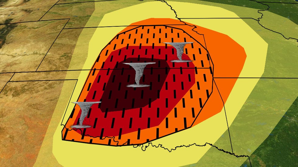
Rare Severe ‘High Risk’; Golf-Ball Size Hail, Tornado Watches Issued
Another widespread bout of severe thunderstorms is expected this week in the Plains and Midwest. Here's a look at the forecast.
Rare Severe ‘High Risk’; Golf-Ball Size Hail, Tornado Watches Issued
Highest-Level Severe Weather Threat Issued For Plains
The National Weather Service has issued its highest-level warning for severe weather Monday as a possible tornado outbreak loomed in the Plains.
Highest-Level Severe Weather Threat Issued For Plains
What 'High Risk' Severe Weather Outlooks Mean; How To Prepare
Here's why a level 5 "high risk" severe weather forecast deserves your attention.
What 'High Risk' Severe Weather Outlooks Mean; How To Prepare
How To Find Your Tornado Safe Space
When a tornado is imminent, it's crucial to find an interior space away from windows. The Weather Channel's Justin Michaels walks you through it.
How To Find Your Tornado Safe Space
Please enable JavaScript to continue using this application.