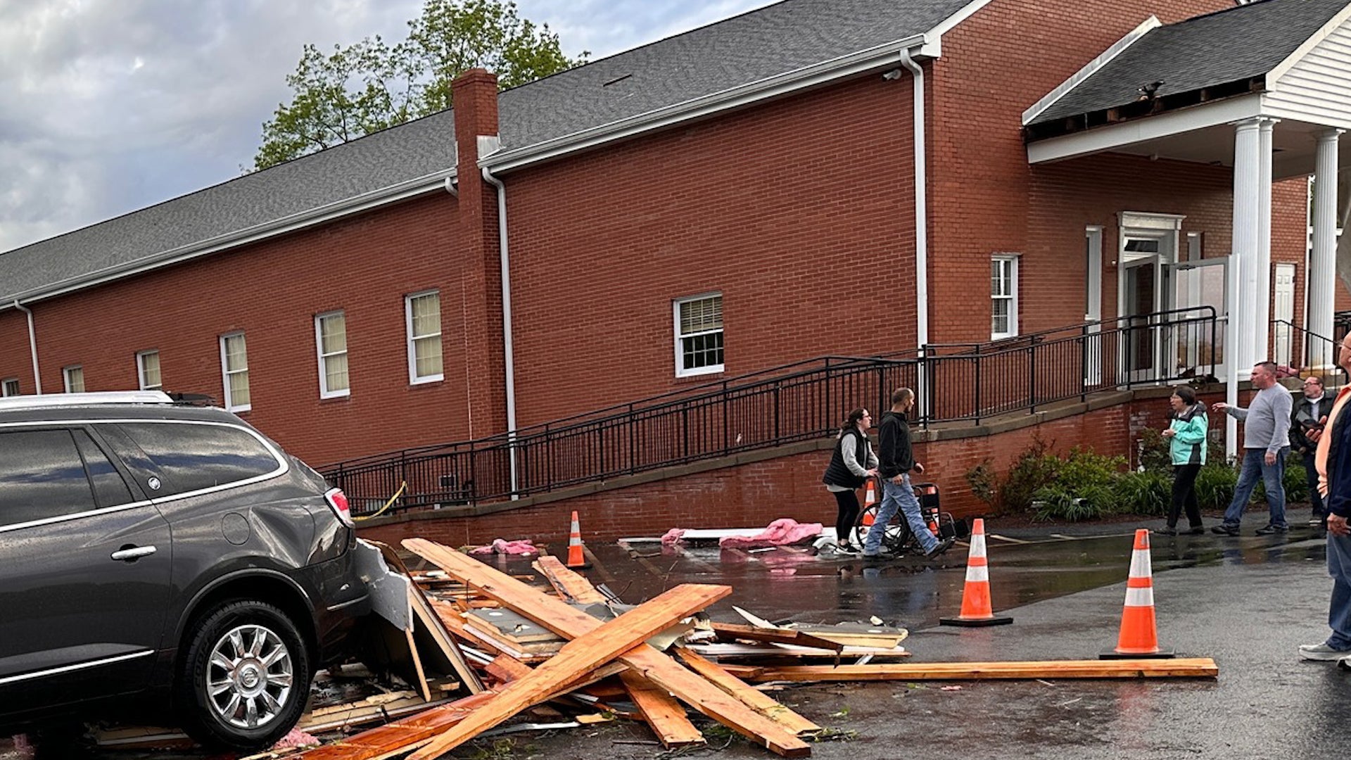
Wales, MA

5:23 PM EST on February 12, 2012 (GMT -0500)
Elev: 994 ft
Lon: 72.2° W
Lat: 42.1° N
Rapid Fire Updates™ Updated 4:58 PM EST Make this Location a Weather Sticker® Share:
Your Custom Weather Sticker®

Copy the following lines of HTML:
Tropical Weather: Tropical Cyclone Giovanna (South Indian Ocean) Tropical Cyclone Jasmine (Southern Pacific)
Weather Summary
Weather Underground Forecast for Sunday, February 12, 2012.

The East dries out on Sunday, but wet weather continues moving through the West. A trough of low pressure advances eastward over the Great Basin and Central Rockies, producing moderate snow showers over Utah and Colorado. Winter weather advisories have been issued for parts of western Colorado as snowfall accumulations may reach from 6 to 8 inches by Sunday evening. Most of Utah, western Wyoming, and northern New Mexico should see lighter snow showers with accumulation around 1 to 2 inches. The tail end of this trough will extend into western Texas, bringing snow and freezing rain showers into northwestern Texas. Precipitation from this system will move into the Texas Panhandle late Sunday into Monday morning. Winter storm warnings have been issued for the region as 3 to 5 inches of snow are possible, with ice accumulations from 0.10 to 0.30 inches by Sunday evening. This will cause dangerous roads and travel conditions.

Meanwhile, another trough of low pressure and associated cold front approach the West Coast on Sunday. This system will reach the coasts of the Pacific Northwest and northern California in the afternoon and evening hours, bringing more rain showers. Temperatures will remain cool over most of the West Coast as this system pushes clouds and moisture onshore.

In the East, a strong ridge of high pressure allows for dry, sunny, and cool weather to persist. This system creates strong flow from the north, pushing cold air into the Plains and Eastern Valleys. Expect highs to range in the 20s in the Midwest, while the Ohio River Valley and Tennessee Valleys will see highs in the 30s. Freeze advisories have been issued for the Gulf states as low temperatures will drop into the 20s Sunday night. Dangerous fire conditions spread over the Southeastern states due to high pressure creating a very dry airmas with strong winds.
Wales Weather at a Glance
Updated 4:58 PM EST
Elevation
814 ft
Report Station
You are about to report this weather station for bad data.

Please select the information which is incorrect and click 'Submit' otherwise click 'Cancel'.

Cancel

Now
Clear
Clear
Temperature
20.8 °F
Feels Like 14 °F
Wind(mph)
5.4
Sunrise / Set
6:49 AM
5:17 PM
Moon
Waning Gibbous
Tonight
Partly Cloudy 9 °F
Partly Cloudy
Tomorrow
Partly Cloudy 34 °F
Partly Cloudy
Tomorrow Night
Partly Cloudy 18 °F
Partly Cloudy
Tuesday
Mostly Cloudy 43 | 25 °F
Mostly Cloudy
Wednesday
Mostly Cloudy 41 | 27 °F
Mostly Cloudy
Thursday
Partly Cloudy 43 | 32 °F
Partly Cloudy
Tomorrow is forecast to be Much Warmer than today.
Conditions
Pressure
29.53 in
Visibility
10.0 miles
Clouds
Clear -
Moisture
Humidity
31%
Rainfall
0.00 in
Snow Depth
Not available.
METAR
METAR KCEF 122155Z AUTO 28020G25KT 10SM CLR M05/M17 A2973 RMK AO2 PK WND 31026/2056 SLP073 T10481165
Don't speak METAR? Read our FAQ.
Weather Radio
Temperature
Windchill
14 °F
Dew Point
-6 °F
Wind
Speed / Dir
5.4 mph from SW
Wind Gust
15.2 mph
Health
UV
0 out of 16
Pollen
.30 out of 12
Pollen Forecast
Ozone
Good
PM2.5
Good
Flu Activity
Local Activity
View Flu Map
Loading…
Regional Forecast for Eastern Hampden
Tonight
nt_partlycloudy Partly cloudy. Lows around 12. Northwest winds 10 to 15 mph. Gusts up to 30 mph this evening.
Monday
partlysunny Partly sunny in the morning...then clearing. Not as cool with highs in the mid 30s. West winds 10 to 15 mph with gusts up to 30 mph.
Monday Night
nt_sunny Clear in the evening...then becoming partly cloudy. Lows around 20. Southwest winds 5 to 10 mph.
Tuesday
cloudy Cloudy. Highs in the lower 40s. Southwest winds 5 to 10 mph.
Tuesday Night
nt_cloudy Cloudy. Not as cool with lows around 30. West winds around 5 mph.
Wednesday
chancerain Cloudy with a chance of rain showers. Highs in the mid 40s. Chance of rain 30 percent.
Wednesday Night
nt_cloudy Mostly cloudy. Lows in the upper 20s.
Thursday
chancerain Partly sunny with a 40 percent chance of rain showers. Highs in the mid 40s.
Thursday Night
nt_chancerain Cloudy with a 50 percent chance of rain showers. Near steady temperature in the upper 30s.
Friday
chancerain Cloudy with a 40 percent chance of showers. Highs in the mid 40s.
Friday Night and Saturday
nt_cloudy Mostly cloudy. Lows in the mid 20s. Highs in the upper 30s.
Saturday Night and Sunday
nt_partlycloudy Partly cloudy. Lows in the lower 20s. Highs in the mid 30s.
Source: NWS at 4:16 PM EST on February 12, 2012
Loading…
 
First Previous Last Next  
Updated:  


Forecast
View Calendar 7-Day Weather Forecast for 01081
Sunday, 12
Partly Cloudy
23 | 9 °F
Partly Cloudy
Chance of
Precipitation
0%
Monday, 13
Partly Cloudy
34 | 18 °F
Partly Cloudy
Chance of
Precipitation
0%
Tuesday, 14
Mostly Cloudy
43 | 25 °F
Mostly Cloudy
Chance of
Precipitation
20%
Wednesday, 15
Mostly Cloudy
41 | 27 °F
Mostly Cloudy
Chance of
Precipitation
10%
Thursday, 16
Partly Cloudy
43 | 32 °F
Partly Cloudy
Chance of
Precipitation
20%
Friday, 17
Chance of Snow
38 | 22 °F
Chance of Snow
Chance of
Precipitation
30%
Saturday, 18
Chance of Snow
38 | NA
Chance of Snow
Chance of
Precipitation
20%
Source: NWS at 4:16 PM EST on February 12, 2012
Regional Forecast for Eastern Hampden
Tonight
nt_partlycloudy Partly cloudy. Lows around 12. Northwest winds 10 to 15 mph. Gusts up to 30 mph this evening.
Hourly Forecast 6AM 12 Noon 6PM 12 Midnight
Temp. | Dew Point 13 | 0 17 | -1 16 | 0 13 | 1
Wind 13 mph NW 17 mph NW 15 mph WNW 7 mph WNW
Humidity 53% 40% 46% 58%
Chance of Precip. 10% 0% 0% 0%
Cloud Cover 13% 22% 47% 34%
Conditions Clear Clear Partly Cloudy Partly Cloudy
Sunrise & Sunset
6:49 AM
5:17 PM
Source: NWS at 4:16 PM EST on February 12, 2012
Regional Forecast for Eastern Hampden
Monday
partlysunny Partly sunny in the morning...then clearing. Not as cool with highs in the mid 30s. West winds 10 to 15 mph with gusts up to 30 mph.
Monday Night
nt_sunny Clear in the evening...then becoming partly cloudy. Lows around 20. Southwest winds 5 to 10 mph.
Hourly Forecast 6AM 12 Noon 6PM 12 Midnight
Temp. | Dew Point 12 | 5 28 | 14 31 | 14 26 | 16
Wind 5 mph West 13 mph West 9 mph West 4 mph WSW
Humidity 74% 54% 49% 68%
Chance of Precip. 0% 0% 0% 0%
Cloud Cover 47% 53% 15% 2%
Conditions Partly Cloudy Partly Cloudy Clear Clear
Sunrise & Sunset
6:48 AM
5:18 PM
Source: NWS at 4:16 PM EST on February 12, 2012
Regional Forecast for Eastern Hampden
Tuesday
cloudy Cloudy. Highs in the lower 40s. Southwest winds 5 to 10 mph.
Tuesday Night
nt_cloudy Cloudy. Not as cool with lows around 30. West winds around 5 mph.
Hourly Forecast 6AM 12 Noon 6PM 12 Midnight
Temp. | Dew Point 21 | 13 37 | 13 37 | 17 30 | 20
Wind 4 mph WSW 6 mph SW 6 mph SSW 2 mph SSW
Humidity 71% 38% 43% 65%
Chance of Precip. 0% 20% 20% 20%
Cloud Cover 57% 91% 98% 99%
Conditions Partly Cloudy Overcast Overcast Chance of Rain
Sunrise & Sunset
6:46 AM
5:19 PM
Source: NWS at 4:16 PM EST on February 12, 2012
Regional Forecast for Eastern Hampden
Wednesday
chancerain Cloudy with a chance of rain showers. Highs in the mid 40s. Chance of rain 30 percent.
Wednesday Night
nt_cloudy Mostly cloudy. Lows in the upper 20s.
Hourly Forecast 6AM 12 Noon 6PM 12 Midnight
Temp. | Dew Point 27 | 23 38 | 26 37 | 27 32 | 27
Wind 1 mph SW 4 mph NW 2 mph NW 1 mph NNW
Humidity 85% 66% 67% 79%
Chance of Precip. 30% 30% 10% 10%
Cloud Cover 98% 80% 75% 61%
Conditions Chance of Snow Mostly Cloudy Mostly Cloudy Partly Cloudy
Sunrise & Sunset
6:45 AM
5:21 PM
Source: NWS at 4:16 PM EST on February 12, 2012
Regional Forecast for Eastern Hampden
Thursday
chancerain Partly sunny with a 40 percent chance of rain showers. Highs in the mid 40s.
Thursday Night
nt_chancerain Cloudy with a 50 percent chance of rain showers. Near steady temperature in the upper 30s.
Hourly Forecast 6AM 12 Noon 6PM 12 Midnight
Temp. | Dew Point 29 | 25 38 | 28 38 | 29 36 | 29
Wind 1 mph NW 5 mph NW 5 mph SW 5 mph SSW
Humidity 84% 66% 68% 77%
Chance of Precip. 10% 10% 20% 20%
Cloud Cover 59% 34% 46% 79%
Conditions Partly Cloudy Partly Cloudy Partly Cloudy Chance of Rain
Sunrise & Sunset
6:44 AM
5:22 PM
Source: NWS at 4:16 PM EST on February 12, 2012
Regional Forecast for Eastern Hampden
Friday
chancerain Cloudy with a 40 percent chance of showers. Highs in the mid 40s.
Friday Night and Saturday
nt_cloudy Mostly cloudy. Lows in the mid 20s. Highs in the upper 30s.
Hourly Forecast 6AM 12 Noon 6PM 12 Midnight
Temp. | Dew Point 33 | 27 37 | 27 32 | 24 26 | 21
Wind 5 mph SSW 8 mph WNW 7 mph West 7 mph WNW
Humidity 81% 69% 71% 76%
Chance of Precip. 40% 40% 30% 30%
Cloud Cover 95% 90% 83% 56%
Conditions Chance of Rain Chance of Snow Chance of Rain Chance of Snow
Sunrise & Sunset
6:44 AM
5:22 PM
Source: NWS at 4:16 PM EST on February 12, 2012
Regional Forecast for Eastern Hampden
Friday Night and Saturday
nt_cloudy Mostly cloudy. Lows in the mid 20s. Highs in the upper 30s.
Saturday Night and Sunday
nt_partlycloudy Partly cloudy. Lows in the lower 20s. Highs in the mid 30s.
Hourly Forecast 6AM 12 Noon 6PM 12 Midnight
Temp. | Dew Point 23 | 17 34 | 16 30 | 14 26 | 21
Wind 7 mph WNW 14 mph WNW 12 mph WNW 7 mph WNW
Humidity 77% 49% 50% 76%
Chance of Precip. 20% 20% 20% 30%
Cloud Cover 41% 31% 43% 56%
Conditions Chance of Snow Chance of Snow Chance of Rain Chance of Snow
Sunrise & Sunset
6:44 AM
5:22 PM
BestForecast (what's this?)
Nearby
History & Almanac
February 12, 2012 Max Temp Min Temp
Normal (KCEF) 34 °F 17 °F
Record (KCEF) 53 °F (1999) 0 °F (2001)
Yesterday 37.8 °F 24.4 °F
Choose a date
Earthquake Activity
City Distance Mag. Time & Date
No recent earthquake activity has been reported nearby.
Minimum magnitude displayed is 2.5.
Air Quality
  Air Quality AQ Index Pollutant
Yesterday Good
PM2.5
Yesterday Good
OZONE
Current Good
OZONE
Current Good
PM2.5
Sunday Good
PM2.5
Sunday Good
OZONE
Monday Good
PM2.5
Monday Good
OZONE
Astronomy
Feb. 12, 2012 Rise Set
Actual Time 6:49 AM EST 5:17 PM EST
Civil Twilight 6:20 AM EST 5:46 PM EST
Nautical Twilight 5:47 AM EST 6:19 PM EST
Astronomical Twilight 5:15 AM EST 6:51 PM EST
Moon 11:19 PM EST 8:59 AM EST
Length Of Visible Light 11h 25m
Length of Day
10h 27m
Tomorrow will be 2m 35s longer.
Waning Gibbous, 70% of the Moon is Illuminated
Today
Waning Gibbous
Feb 14
Last Quarter
Feb 21
New
Feb 29
First Quarter
Mar 8
Full
Today's Extremes
State Highs State Lows
35 °F
Nantucket
34 °F
Chatham
33 °F
Hyannis
33 °F
Provincetown
6 °F
Pittsfield
9 °F
North Adams
10 °F
Worcester
10 °F
Orange
12 °F
East Milton
Source: NWS
Snow Depth
Station Depth Elevation
No new snow has been reported.
WunderPhotos®
Ice moving through on the Danube river
Sotto la neve
Uploaded by: Danube
1,457,062 photos uploaded!
WunderBlogs®

There are no recent blogs in this area. Why not create your own?

Travel & Activities
Travel Planning
Destination? *
When are you going?
to
Is there an activity you would like to explore?
* Required field
Aviation
City Temp. Conditions Updated
Chicopee 23 °F Clear 4:55 PM EST
Willimantic 27 °F Overcast 4:52 PM EST
Worcester 20 °F Partly Cloudy 4:54 PM EST
Windsor Locks 25 °F Scattered Clouds 4:51 PM EST
Flight To ETA Status
GGN7434
Montreal, Quebec
KBDL 05:26PM On Time
JBU230
West Palm Beach, FL
KBDL 05:39PM On Time
CPZ5719
Minneapolis, MN
KBDL 05:46PM On Time
UPS1064
Louisville, KY
KBDL 06:21PM On Time
Flight Tracker by FlightAware FlightAware
Type Condition
Flight Rule: VFR (KCEF)
Wind Speed: 20.0 kts.
Wind Dir: 225° (SW)
Ceiling: Unlimited

METAR KCEF 122155Z AUTO 28020G25KT 10SM CLR M05/M17 A2973 RMK AO2 PK WND 31026/2056 SLP073 T10481165

Nearby Events
Event Date Forecast
Lisa Martin 7:00 PM EST 2012-02-16 Chance of Rain, 41°F
Event data courtesy eviesays.com
Sports
Event Date Forecast
Budweiser Shootout 8:29 PM EST on February 18, 2012 Partly Cloudy, 59 °F
Gatorade Duel 1 2:19 PM EST on February 23, 2012 Average High 70° F/ 21° C
Event Date Forecast
AT&T Pebble Beach National Pro-Am 8:30 AM PST on February 12, 2012 Mostly Cloudy, 45 °F
Northern Trust Open 8:30 AM PST on February 16, 2012 Clear, 61 °F
Weather Stations
Station Location Temp. Windchill Dew Point Humidity Wind Precipitation Elevation Updated Type Website
Monson/Wales Town Line, Monson, MA 20.8 °F 14 °F -6 °F 31% SW  at  5.4 mph 0.00 in / hr 814 ft 4:58 PM EST Normal
Stickney Hill, Union, CT 18.2 °F 18 °F 3 °F 50% North  at  - - / hr 1050 ft 5:20 PM EST Normal  
APRSWXNET Union CT , Stafford Springs, CT 17 °F 17 °F 2 °F 52% North  at  - 0.00 in / hr 1253 ft 5:00 PM EST MADIS
Hunter's Ridge, Stafford Springs, Ct 20.8 °F 15 °F 2 °F 43% SSE  at  4.0 mph 0.00 in / hr 788 ft 5:23 PM EST Rapid Fire  
HADS EAST BRIMFIELD LAKE , Fiskdale, MA 26 °F 26 °F - - North  at  - 0.00 in / hr 850 ft 4:30 PM EST MADIS
Brendan Heights, Stafford Springs, CT 19.9 °F 14 °F 6 °F 53% North  at  3.8 mph 0.00 in / hr 650 ft 5:20 PM EST Normal  
APRSWXNET Sturbridge M, Fiskdale, MA 22 °F 22 °F 3 °F 43% WSW  at  3 mph 0.00 in / hr 708 ft 5:03 PM EST MADIS
APRSWXNET Warren MA , Warren, MA 22 °F 22 °F - - NW  at  1 mph 0.00 in / hr 675 ft 5:02 PM EST MADIS
whipples, Palmer, MA 22.5 °F 16 °F -3 °F 32% NW  at  4.5 mph 0.00 in / hr 433 ft 5:23 PM EST Rapid Fire  
Three Rivers, MA 22.4 °F 17 °F 4 °F 45% SW  at  4.0 mph 0.00 in / hr 331 ft 5:10 PM EST Normal  
NE Tolland, Tolland, CT 21.7 °F 22 °F 2 °F 42% NW  at  2.2 mph 0.00 in / hr 710 ft 5:23 PM EST Rapid Fire  
APRSWXNET Woodstock CT , Woodstock, CT 21 °F 11 °F 5 °F 50% West  at  8 mph 0.00 in / hr 908 ft 5:04 PM EST MADIS
Ashford, Ashford, CT 21.2 °F 21 °F 4 °F 47% WNW  at  2.0 mph 0.00 in / hr 502 ft 5:20 PM EST Normal  
East Longmeadow, East Longmeadow, MA 23.5 °F 24 °F 2 °F 39% NNE  at  2.2 mph 0.00 in / hr 255 ft 5:15 PM EST Normal
APRSWXNET Ashford CT , Ashford, CT 22 °F 22 °F 6 °F 50% North  at  3 mph 0.00 in / hr 695 ft 5:01 PM EST MADIS
APRSWXNET Brookfield MA , Brookfield, MA 22 °F 22 °F 2 °F 41% West  at  2 mph 0.00 in / hr 682 ft 5:01 PM EST MADIS
Crystal Lake, Ellington, CT 23.9 °F 18 °F 7 °F 48% WSW  at  4.9 mph 0.00 in / hr 686 ft 5:22 PM EST Rapid Fire  
Hidden in the woods, Charlton, MA 23.3 °F 23 °F 4 °F 43% ENE  at  3.0 mph 0.00 in / hr 680 ft 3:53 PM EST Normal
NEAR MEADOWBROOK SCHOOL, East Longmeadow, MA 22.9 °F 18 °F 6 °F 48% WSW  at  4.0 mph 0.00 in / hr 250 ft 5:09 PM EST Normal  
Leela Way, Tolland, CT 21.1 °F 12 °F 7 °F 54% WNW  at  8.0 mph 0.00 in / hr 848 ft 5:22 PM EST Normal  
Goodwin Dr, Somers, CT 23.7 °F 11 °F 5 °F 43% North  at  14.5 mph 0.00 in / hr 117 ft 5:23 PM EST Rapid Fire
Willington Hill, Willington, CT 22.9 °F 11 °F 5 °F 46% NW  at  12.0 mph 0.00 in / hr 650 ft 5:15 PM EST Normal
Ragged Hill, West Brookfield, MA 18.9 °F 9 °F 4 °F 52% NW  at  8.0 mph 0.00 in / hr 912 ft 5:20 PM EST Normal  
Belchertown, MA 21.8 °F 14 °F 5 °F 48% WNW  at  6.3 mph 0.00 in / hr 656 ft 5:15 PM EST Normal
North Brookfield, MA 20.1 °F 20 °F -2 °F 37% North  at  0.0 mph 0.00 in / hr 825 ft 5:23 PM EST Rapid Fire  
Hurlbut Rd, Tolland, CT 23.7 °F 24 °F 25 °F 25% NNW  at  0.0 mph - / hr 568 ft 5:22 PM EST Normal  
Masons Mill, Storrs, CT 25.2 °F 25 °F 9 °F 50% NNE  at  1.0 mph 0.00 in / hr 350 ft 5:23 PM EST Rapid Fire  
Tolland, CT 22.0 °F 13 °F 9 °F 57% NNW  at  7.0 mph - / hr 750 ft 5:15 PM EST Normal  
Island Pond, Springfield, MA 23.5 °F 16 °F 0 °F 36% South  at  6.5 mph 0.00 in / hr 190 ft 5:23 PM EST Rapid Fire
Eastford, CT 23.8 °F 19 °F 8 °F 50% NNW  at  4.0 mph 0.00 in / hr 500 ft 5:21 PM EST Normal
Forest Park Section, Springfield, MA 23.9 °F 20 °F -9 °F 22% NNW  at  3.1 mph 0.00 in / hr 206 ft 5:23 PM EST Normal
HADS BUFFUMVILLE LAKE , Oxford, MA 23 °F 23 °F - - North  at  - 0.00 in / hr 490 ft 4:30 PM EST MADIS
Spencer, MA 20.8 °F 12 °F -3 °F 34% NNW  at  6.9 mph 0.00 in / hr 881 ft 5:23 PM EST Rapid Fire  
Spencer, MA 18.3 °F 14 °F -17 °F 19% WNW  at  3.1 mph 0.00 in / hr 995 ft 5:23 PM EST Rapid Fire  
Ellington Weather, Ellington, CT 24.3 °F 17 °F 4 °F 42% WNW  at  6.3 mph 0.00 in / hr 283 ft 5:22 PM EST Rapid Fire  
Whitacres Park, Enfield, CT 23.5 °F 18 °F 8 °F 50% NNE  at  4.0 mph 0.00 in / hr 172 ft 5:22 PM EST Rapid Fire
TheKenwoods, Spencer, MA 20.8 °F 21 °F -1 °F 38% East  at  2.2 mph 0.00 in / hr 839 ft 5:15 PM EST Normal  
Springfield DPW, Springfield, MA 22.0 °F 12 °F - - NW  at  9.0 mph -0.30 in / hr 220 ft 5:23 PM EST Rapid Fire
NE Connecticut, Quinebaug, CT 23.0 °F 23 °F 7 °F 50% NNE  at  2.7 mph - / hr - 5:16 PM EST Normal
Would you like to share your weather data with the rest of the world? Add Your Weather Station!