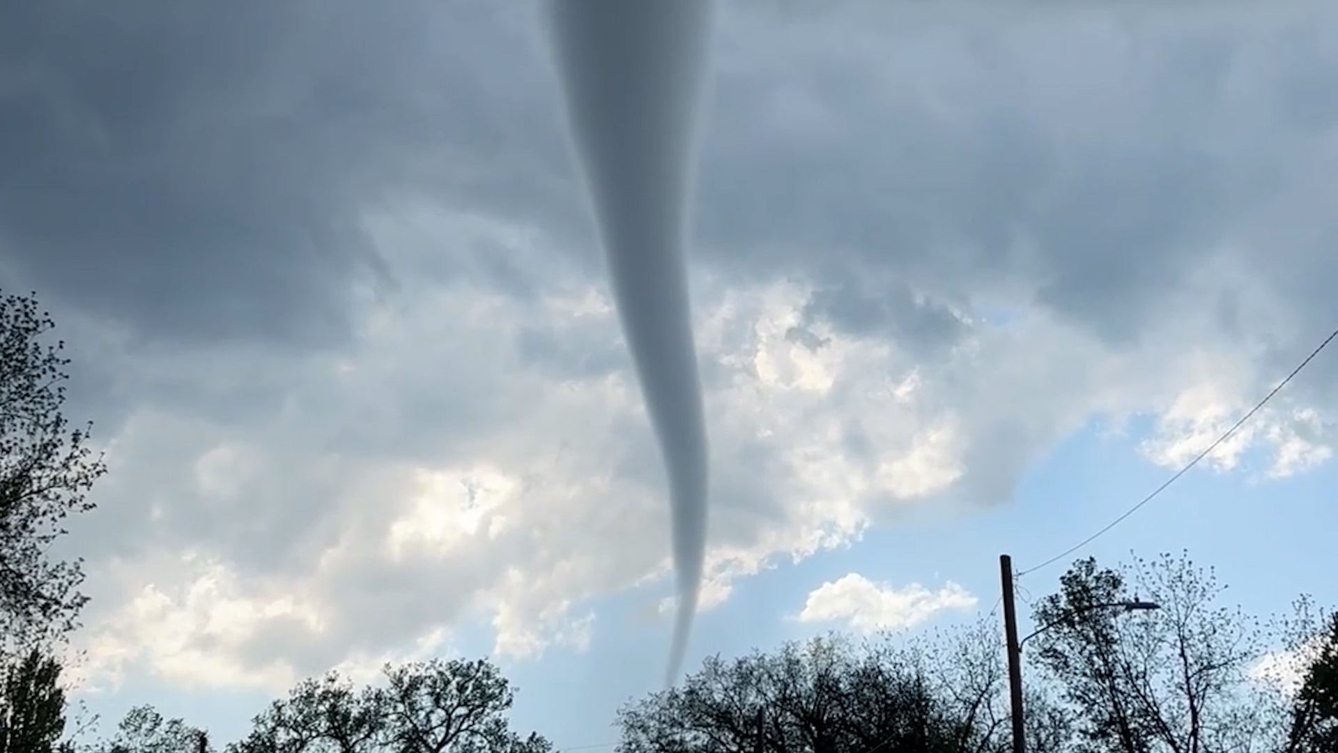
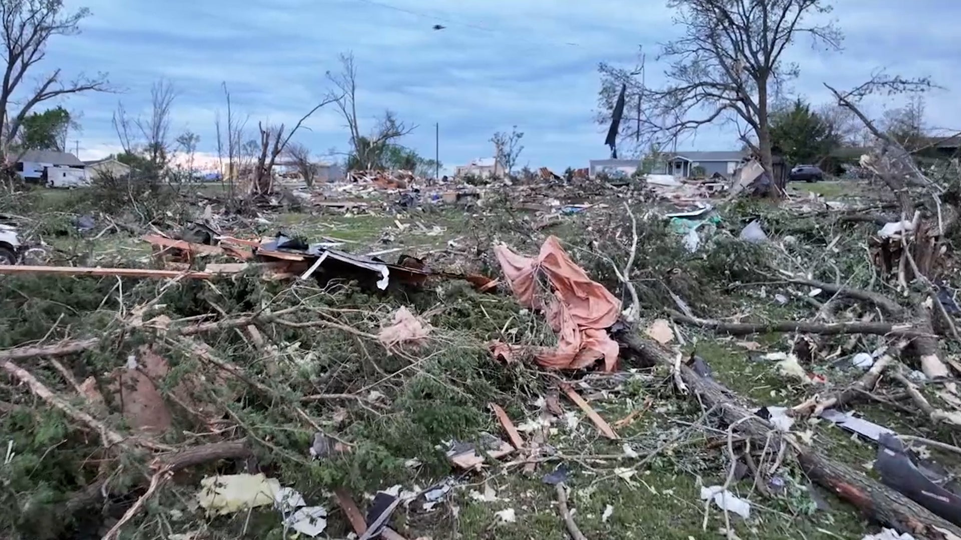
Daytona Beach, FL

8:59 PM EST on February 09, 2012 (GMT -0500)
Elev: 39 ft
Lon: 81.0° W
Lat: 29.2° N
Rapid Fire Updates™ Updated 8:59 PM EST Make this Location a Weather Sticker® Share:
Your Custom Weather Sticker®

Copy the following lines of HTML:
Tropical Weather: Tropical Cyclone Twelve (South Indian Ocean) Tropical Cyclone Jasmine (Southern Pacific)
Weather Summary
Weather Underground midday recap for Thursday, February 09, 2012.

Areas of active weather developed over the West on Thursday, while Texas saw a mix of snow, freezing rain, and rain. A trough of low pressure moved off the Southern Rockies and into the Southern Plains. This allowed for snow showers to end over New Mexico and moved into northern Texas and Oklahoma. Snowfall accumulation in northern New Mexico ranged from 1 to 3 inches, while the panhandle of Texas saw an inch of snow and ice accumulation up to a tenth of an inch. Winter weather advisories have been issued for parts of the Southern Plains as this system created dangerous road and travel conditions. To the south, onshore flow from the Gulf of Mexico pushed moist air into eastern Texas. This kicked up scattered showers and thunderstorms from northeastern Mexico and through southeastern Texas. These storms have not yet turned severe.

In the West, a low pressure system in the Gulf of Alaska continued pushing a warm front into the Pacific Northwest. Temperatures increased as this system moved onshore, which increased snow levels across the Washington Cascades. Precipitation remained as rain showers in most areas. Rainfall totals ranged around 1 inch, with heaviest rainfall totals up to 1.12 inches in Chehalis, Washington.

Back East, a ridge of high pressure covered the Mississippi River Valley and Eastern US. This pushed cool and dry air in from Canada and created sunny skies with brisk conditions. High temperatures ranged in the 30s across the Great Lakes region, while the Northeast and Mid-Atlantic states reached into the upper 40s.
Daytona Beach Weather at a Glance
Updated 8:59 PM EST
Elevation
26 ft
Report Station
You are about to report this weather station for bad data.

Please select the information which is incorrect and click 'Submit' otherwise click 'Cancel'.

Cancel

Now
Overcast
Overcast
Temperature
63.3 °F
Feels Like 63.3 °F
Wind(mph)
3.0
Sunrise / Set
7:08 AM
6:08 PM
Moon
Waning Gibbous
Tonight
Mostly Cloudy 56 °F
Mostly Cloudy
Tomorrow
Chance of Rain 74 °F
Chance of Rain
40% chance of precipitation
Tomorrow Night
Rain Showers 58 °F
Rain Showers
60% chance of precipitation
Saturday
Chance of Rain 67 | 38 °F
Chance of Rain
20% chance of precipitation
Sunday
Partly Cloudy 58 | 40 °F
Partly Cloudy
Monday
Partly Cloudy 65 | 49 °F
Partly Cloudy
Tomorrow is forecast to be Warmer than today.
Conditions
Pressure
30.12 in
Visibility
10.0 miles
Clouds
Few 3500 ft
Overcast 15000 ft
Moisture
Humidity
87%
Rainfall
0.00 in
Snow Depth
Not available.
METAR
METAR KDAB 100153Z 01005KT 10SM FEW035 OVC150 17/14 A3015 RMK AO2 SLP210 BINOVC T01670139
Don't speak METAR? Read our FAQ.
Weather Radio
Temperature
Temperature
63.3 °F
Dew Point
59 °F
Wind
Speed / Dir
3.0 mph from North
Wind Gust
7.0 mph
Health
UV
0.0 out of 16
Pollen
9.00 out of 12
Pollen Forecast
Air Quality
Not available.
Flu Activity
Sporadic
View Flu Map
Loading…
Regional Forecast for Coastal Volusia County
Tonight
nt_cloudy Mostly cloudy. Lows in the upper 50s. Northeast winds 5 to 10 mph.
Friday
chancerain Cloudy with a chance of showers. Highs in the mid 70s. East winds 5 to 10 mph. Chance of rain 50 percent.
Friday Night
nt_rain Cloudy with showers likely. Lows in the upper 50s. South winds 5 to 10 mph becoming northwest 10 to 15 mph after midnight. Chance of rain 60 percent.
Saturday
cloudy Mostly cloudy with a slight chance of showers in the morning...then partly sunny in the afternoon. Highs in the upper 60s. Northwest winds 10 to 15 mph. Chance of rain 20 percent.
Saturday Night
nt_sunny Mostly clear. Breezy...colder. Lows in the upper 30s. Northwest winds 15 to 20 mph. Lowest wind chill readings 28 to 31 after midnight.
Sunday
partlysunny Partly sunny. Breezy...cooler. Highs in the upper 50s.
Sunday Night
nt_partlycloudy Partly cloudy. Lows around 40.
Monday
partlysunny Partly sunny. Highs in the upper 60s.
Monday Night
nt_partlycloudy Partly cloudy. Lows around 50.
Tuesday
partlysunny Partly sunny. Highs in the mid 70s.
Tuesday Night
nt_partlycloudy Partly cloudy. Lows in the upper 50s.
Wednesday
partlycloudy Partly cloudy. Highs in the upper 70s.
Wednesday Night
nt_partlycloudy Partly cloudy. Lows in the upper 50s.
Thursday
partlycloudy Partly cloudy. Highs in the upper 70s.
Source: NWS at 3:29 PM EST on February 9, 2012
Loading…
 
First Previous Last Next  
Updated:  


Forecast
View Calendar 7-Day Weather Forecast for 32114
Thursday, 9
Partly Cloudy
68 | 56 °F
Partly Cloudy
Chance of
Precipitation
10%
Friday, 10
Chance of Rain
74 | 58 °F
Chance of Rain
Chance of
Precipitation
40%
Saturday, 11
Chance of Rain
67 | 38 °F
Chance of Rain
Chance of
Precipitation
20%
Sunday, 12
Partly Cloudy
58 | 40 °F
Partly Cloudy
Chance of
Precipitation
10%
Monday, 13
Partly Cloudy
65 | 49 °F
Partly Cloudy
Chance of
Precipitation
10%
Tuesday, 14
Partly Cloudy
74 | 56 °F
Partly Cloudy
Chance of
Precipitation
10%
Wednesday, 15
Partly Cloudy
76 | 58 °F
Partly Cloudy
Chance of
Precipitation
10%
Thursday, 16
Partly Cloudy
77 | NA
Partly Cloudy
Chance of
Precipitation
10%
Source: NWS at 3:29 PM EST on February 9, 2012
Regional Forecast for Coastal Volusia County
Tonight
nt_cloudy Mostly cloudy. Lows in the upper 50s. Northeast winds 5 to 10 mph.
Hourly Forecast 6AM 12 Noon 6PM 12 Midnight
Temp. | Dew Point 54 | 45 66 | 47 64 | 51 58 | 54
Wind 6 mph North 11 mph North 6 mph NE 3 mph NE
Humidity 71% 51% 61% 82%
Chance of Precip. 0% 10% 10% 10%
Cloud Cover 51% 60% 70% 70%
Conditions Partly Cloudy Partly Cloudy Mostly Cloudy Mostly Cloudy
Sunrise & Sunset
7:08 AM
6:08 PM
Source: NWS at 3:29 PM EST on February 9, 2012
Regional Forecast for Coastal Volusia County
Friday
chancerain Cloudy with a chance of showers. Highs in the mid 70s. East winds 5 to 10 mph. Chance of rain 50 percent.
Friday Night
nt_rain Cloudy with showers likely. Lows in the upper 50s. South winds 5 to 10 mph becoming northwest 10 to 15 mph after midnight. Chance of rain 60 percent.
Hourly Forecast 6AM 12 Noon 6PM 12 Midnight
Temp. | Dew Point 58 | 54 70 | 60 67 | 61 62 | 59
Wind 4 mph ENE 7 mph East 3 mph East 11 mph SW
Humidity 86% 69% 80% 90%
Chance of Precip. 10% 50% 50% 60%
Cloud Cover 85% 86% 86% 90%
Conditions Mostly Cloudy Chance of Rain Chance of Rain Rain Showers
Sunrise & Sunset
7:07 AM
6:09 PM
Source: NWS at 3:29 PM EST on February 9, 2012
Regional Forecast for Coastal Volusia County
Saturday
cloudy Mostly cloudy with a slight chance of showers in the morning...then partly sunny in the afternoon. Highs in the upper 60s. Northwest winds 10 to 15 mph. Chance of rain 20 percent.
Saturday Night
nt_sunny Mostly clear. Breezy...colder. Lows in the upper 30s. Northwest winds 15 to 20 mph. Lowest wind chill readings 28 to 31 after midnight.
Hourly Forecast 6AM 12 Noon 6PM 12 Midnight
Temp. | Dew Point 58 | 53 65 | 48 60 | 42 51 | 35
Wind 13 mph WNW 13 mph WNW 13 mph NW 15 mph NW
Humidity 85% 55% 49% 55%
Chance of Precip. 60% 20% 20% 10%
Cloud Cover 90% 80% 30% 21%
Conditions Rain Showers Chance of Rain Partly Cloudy Clear
Sunrise & Sunset
7:06 AM
6:10 PM
Source: NWS at 3:29 PM EST on February 9, 2012
Regional Forecast for Coastal Volusia County
Sunday
partlysunny Partly sunny. Breezy...cooler. Highs in the upper 50s.
Sunday Night
nt_partlycloudy Partly cloudy. Lows around 40.
Hourly Forecast 6AM 12 Noon 6PM 12 Midnight
Temp. | Dew Point 40 | 28 56 | 37 52 | 39 46 | 40
Wind 13 mph NNW 13 mph North 9 mph NNE 6 mph NNE
Humidity 63% 50% 60% 82%
Chance of Precip. 10% 10% 10% 10%
Cloud Cover 10% 45% 45% 40%
Conditions Clear Partly Cloudy Partly Cloudy Partly Cloudy
Sunrise & Sunset
7:05 AM
6:11 PM
Source: NWS at 3:29 PM EST on February 9, 2012
Regional Forecast for Coastal Volusia County
Monday
partlysunny Partly sunny. Highs in the upper 60s.
Monday Night
nt_partlycloudy Partly cloudy. Lows around 50.
Hourly Forecast 6AM 12 Noon 6PM 12 Midnight
Temp. | Dew Point 41 | 40 59 | 44 59 | 48 53 | 49
Wind 6 mph NNE 7 mph NE 6 mph East 6 mph East
Humidity 97% 60% 66% 83%
Chance of Precip. 10% 10% 10% 10%
Cloud Cover 40% 38% 38% 44%
Conditions Partly Cloudy Partly Cloudy Partly Cloudy Partly Cloudy
Sunrise & Sunset
7:05 AM
6:11 PM
Source: NWS at 3:29 PM EST on February 9, 2012
Regional Forecast for Coastal Volusia County
Tuesday
partlysunny Partly sunny. Highs in the mid 70s.
Tuesday Night
nt_partlycloudy Partly cloudy. Lows in the upper 50s.
Hourly Forecast 6AM 12 Noon 6PM 12 Midnight
Temp. | Dew Point 52 | 50 69 | 53 68 | 56 60 | 56
Wind 6 mph SSE 6 mph South 6 mph South 7 mph SSE
Humidity 94% 62% 68% 86%
Chance of Precip. 10% 10% 10% 10%
Cloud Cover 44% 49% 49% 50%
Conditions Partly Cloudy Partly Cloudy Partly Cloudy Partly Cloudy
Sunrise & Sunset
7:05 AM
6:11 PM
Source: NWS at 3:29 PM EST on February 9, 2012
Regional Forecast for Coastal Volusia County
Wednesday
partlycloudy Partly cloudy. Highs in the upper 70s.
Wednesday Night
nt_partlycloudy Partly cloudy. Lows in the upper 50s.
Thursday
partlycloudy Partly cloudy. Highs in the upper 70s.
Hourly Forecast 6AM 12 Noon 6PM 12 Midnight
Temp. | Dew Point 58 | 56 71 | 56 69 | 58 62 | 58
Wind 6 mph South 6 mph South 6 mph South 7 mph SE
Humidity 95% 60% 66% 84%
Chance of Precip. 10% 10% 10% 10%
Cloud Cover 50% 50% 50% 50%
Conditions Partly Cloudy Partly Cloudy Partly Cloudy Partly Cloudy
Sunrise & Sunset
7:05 AM
6:11 PM
Source: NWS at 3:29 PM EST on February 9, 2012
Regional Forecast for Coastal Volusia County
Thursday
partlycloudy Partly cloudy. Highs in the upper 70s.
Hourly Forecast 6AM 12 Noon 6PM 12 Midnight
Temp. | Dew Point 59 | 56 73 | 60 69 | 61 62 | 58
Wind 6 mph South 6 mph South 6 mph SSW 7 mph SE
Humidity 89% 67% 75% 84%
Chance of Precip. 10% 10% 10% 10%
Cloud Cover 50% 50% 50% 50%
Conditions Partly Cloudy Partly Cloudy Partly Cloudy Partly Cloudy
Sunrise & Sunset
7:05 AM
6:11 PM
BestForecast (what's this?)
Nearby
History & Almanac
February 9, 2012 Max Temp Min Temp
Normal (KDAB) 70 °F 48 °F
Record (KDAB) 85 °F (1949) 27 °F (1995)
Yesterday 73 °F 53 °F
Yesterday's Heating Degree Days: 2
Choose a date
Earthquake Activity
City Distance Mag. Time & Date
No recent earthquake activity has been reported nearby.
Minimum magnitude displayed is 2.5.
Coastal Water Temperatures
Place Temperature
Trident Pier, FL 70.0 °F
Mayport (Bar Pilots Dock), FL 62.1 °F
Fernandina Beach, FL 63.0 °F
Astronomy
Feb. 09, 2012 Rise Set
Actual Time 7:08 AM EST 6:08 PM EST
Civil Twilight 6:43 AM EST 6:33 PM EST
Nautical Twilight 6:15 AM EST 7:01 PM EST
Astronomical Twilight 5:47 AM EST 7:29 PM EST
Moon 8:18 PM EST (2/9) 7:57 AM EST (2/9)
Length Of Visible Light 11h 49m
Length of Day
11h 00m
Tomorrow will be 1m 32s longer.
Waning Gibbous, 94% of the Moon is Illuminated
Today
Waning Gibbous
Feb 14
Last Quarter
Feb 21
New
Feb 29
First Quarter
Mar 8
Full
Today's Extremes
State Highs State Lows
80 °F
Naples
80 °F
Fort Myers
79 °F
Key West
79 °F
Opa Locka
78 °F
Marathon
36 °F
Crestview
37 °F
Milton
39 °F
Valparaiso
39 °F
Crestview
Source: NWS
Snow Depth
Station Depth Elevation
No new snow has been reported.
WunderPhotos®
Some pics of showers and storms that moved into South West Florida.
Star Bellatrix
Uploaded by: Tom01507
1,455,973 photos uploaded!
WunderBlogs®

There are no recent blogs in this area. Why not create your own?

Travel & Activities
Travel Planning
Destination? *
When are you going?
to
Is there an activity you would like to explore?
* Required field
Aviation
City Temp. Conditions Updated
Daytona Beach 62 °F Overcast 8:53 PM EST
Ormond Beach 61 °F Scattered Clouds 6:50 PM EST
New Smyrna Beach 64 °F Mostly Cloudy 6:47 PM EST
Sanford 62 °F Scattered Clouds 8:53 PM EST
Flight To ETA Status
ASH2633
Charlotte, NC
KDAB 09:35PM On Time
AAY799
Plattsburgh, NY
KSFB 09:05PM On Time
AAY607
Youngstown/Warren, OH
KSFB 09:31PM On Time
Flight Tracker by FlightAware FlightAware
Type Condition
Flight Rule: VFR (KDAB)
Wind Speed: 5.0 kts.
Wind Dir: (North)
Ceiling: 15000 ft

METAR KDAB 100153Z 01005KT 10SM FEW035 OVC150 17/14 A3015 RMK AO2 SLP210 BINOVC T01670139

Nearby Events
Event Date Forecast
Chompin' At The Bit String Band at Contra Dance 8:00 PM EST 2012-02-10 Chance of Rain, 65°F
GoRo Charity Dinner and Auction at Mango Sun Cafe, Ormond Beach, Fl 5:00 PM EST 2012-02-10 Chance of Rain, 71°F
Home Grown Roots Band Showcase (9 Live Bands) 8:00 PM EST 2012-02-10 Chance of Rain, 65°F
Daytona State College community screening of American Teacher (Theater Center, Main Campus) 7:00 PM EST 2012-02-10 Chance of Rain, 66°F
Jerry Seinfeld 7:00 PM EST 2012-02-11 Mostly Cloudy, 59°F
Motown & Mo: a Fantastic Musical Voyage \"The Love Boat\" 6:00 PM EST 2012-02-11 Chance of Rain, 62°F
Event data courtesy eviesays.com
Sports
Event Date Forecast
Budweiser Shootout 8:29 PM EST on February 18, 2012 Average High 71° F/ 21° C
Gatorade Duel 1 2:19 PM EST on February 23, 2012 Average High 70° F/ 21° C
Gatorade Duel 2 4:00 PM EST on February 23, 2012 Average High 70° F/ 21° C
Daytona 500 1:30 PM EST on February 26, 2012 Average High 70° F/ 21° C
Event Date Forecast
AT&T Pebble Beach National Pro-Am 8:30 AM PST on February 10, 2012 Partly Cloudy, 45 °F
AT&T Pebble Beach National Pro-Am 8:30 AM PST on February 11, 2012 Chance of Rain, 45 °F
Weather Stations
Station Location Temp. Dew Point Humidity Wind Precipitation Elevation Updated Type Website
ERAU Daytona Beach, Daytona Beach, FL 63.3 °F 59 °F 87% North  at  3.0 mph 0.00 in / hr 26 ft 8:59 PM EST Rapid Fire  
Daytona Beach, FL 65.3 °F 62 °F 89% North  at  9.0 mph - / hr 0 ft 8:50 PM EST Normal  
pines, Ormond Beach, FL 63.0 °F 60 °F 89% North  at  0.0 mph 0.00 in / hr 20 ft 8:59 PM EST Rapid Fire  
Port Orange, FL 63.5 °F 54 °F 72% NNE  at  4.0 mph 0.00 in / hr 15 ft 8:59 PM EST Rapid Fire  
Ormond Beach Police Department - Central, Ormond Beach, FL 62.8 °F - - NNE  at  3.0 mph 0.00 in / hr 25 ft 8:59 PM EST Rapid Fire
Dunlawton / Yorktowne, Port Orange, FL 64.6 °F 59 °F 83% West  at  2.0 mph 0.00 in / hr 29 ft 8:59 PM EST Rapid Fire
Ormond Beach Wastewater Plant - North, Ormond Beach, FL 62.5 °F 59 °F 89% NNE  at  3.0 mph 0.00 in / hr 22 ft 8:59 PM EST Rapid Fire
Wilbur by the Sea, Port Orange, FL 63.9 °F 59 °F 85% NNE  at  8.0 mph 0.00 in / hr 16 ft 8:38 PM EST Normal
Ormond Beach near Tamoka, Ormond Beach, FL 63.0 °F 63 °F 99% NNE  at  3.1 mph 0.00 in / hr 13 ft 8:59 PM EST Rapid Fire  
NonFedAWOS SPRUCECREEK , Daytona Beach, FL 63 °F 55 °F 77% North  at  0 mph 0.00 in / hr 23 ft 8:35 PM EST MADIS
Spruce Creek Fly-In, Daytona Beach, FL 63.1 °F 57 °F 80% NW  at  0.0 mph 0.00 in / hr 21 ft 8:59 PM EST Rapid Fire
KOMN - Ormond Beach Airport Control Towe, Ormond Beach, FL 60.8 °F 58 °F 89% North  at  5.0 mph 0.00 in / hr 50 ft 8:59 PM EST Rapid Fire
KI4FIA - Daytona Beach (Ponce Inlet), Daytona Beach, FL 64.2 °F 61 °F 89% NNE  at  4.0 mph 0.00 in / hr 12 ft 8:59 PM EST Rapid Fire
Isleboro, New Smyrna Beach, FL 63.6 °F 60 °F 87% NNW  at  2.0 mph 0.00 in / hr 28 ft 8:59 PM EST Rapid Fire  
Corbin Park, New Smyrna Beach, FL 64.4 °F 59 °F 84% SSE  at  0.0 mph 0.00 in / hr 39 ft 8:55 PM EST Normal  
New Smyrna RV Park, New Smyrna Beach, FL 63.2 °F 60 °F 88% WSW  at  0.0 mph 0.00 in / hr 13 ft 8:59 PM EST Rapid Fire  
Dragonfly Farm, New Smyrna Beach, FL 60.4 °F 60 °F 99% East  at  0.7 mph 0.00 in / hr 43 ft 8:59 PM EST Rapid Fire  
Florida Shores (North), Edgewater, FL 64.2 °F 57 °F 77% NNW  at  2.5 mph 0.00 in / hr 15 ft 8:59 PM EST Rapid Fire  
Florida Shores, Edgewater, FL 63.8 °F 60 °F 86% NNW  at  2.0 mph 0.00 in / hr 6 ft 8:54 PM EST Normal
Deltona Weather, Deltona, FL 60.4 °F 51 °F 72% North  at  3.0 mph 0.00 in / hr 53 ft 8:55 PM EST Normal
Victoria Hills, DeLand, FL 61.0 °F 57 °F 86% East  at  2.0 mph 0.00 in / hr 79 ft 8:49 PM EST Normal
RAWS LAKE WOODRUFF QD FL, Deland, FL 62 °F 53 °F 73% WNW  at  3 mph 0.00 in / hr 60 ft 7:59 PM EST MADIS
Glenwood Hammock, DeLand, FL 60.6 °F 56 °F 84% NNE  at  0.0 mph - / hr 49 ft 8:53 PM EST Normal  
Flagler Beach, FL 62.1 °F 59 °F 89% NW  at  10.0 mph 0.00 in / hr 16 ft 8:59 PM EST Rapid Fire
Orange City, Orange City, FL 61.6 °F 55 °F 79% East  at  0.0 mph 0.00 in / hr 55 ft 8:59 PM EST Rapid Fire  
SW Deltona, Deltona, FL 61.5 °F 54 °F 77% NE  at  0.0 mph 0.00 in / hr 0 ft 8:59 PM EST Rapid Fire  
Would you like to share your weather data with the rest of the world? Add Your Weather Station!