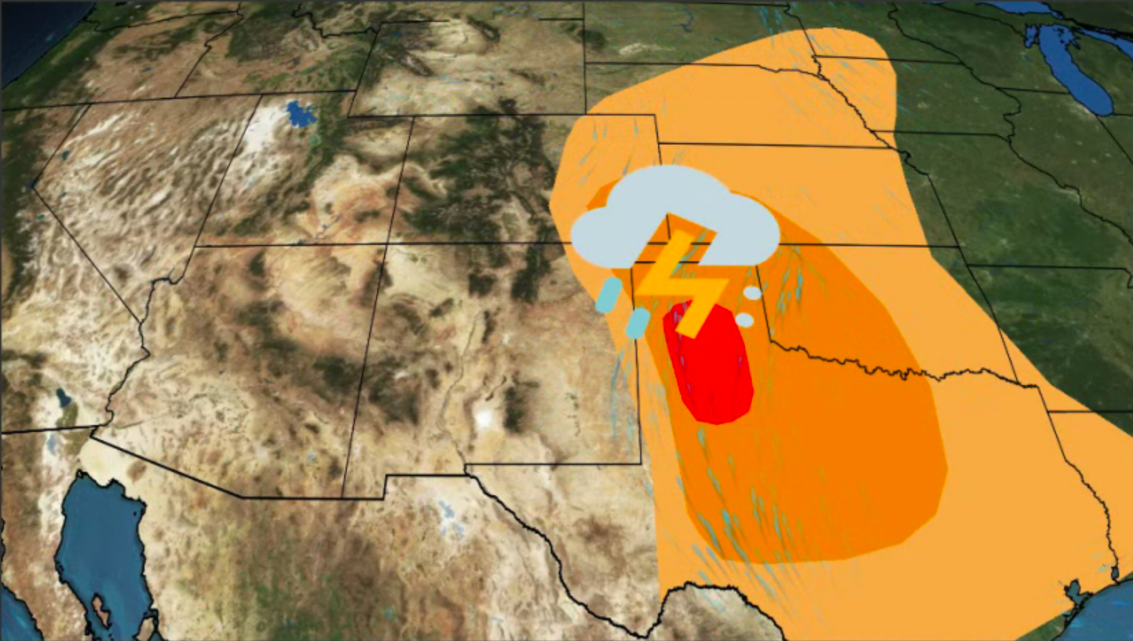
Vista, CA

5:38 AM PST on February 12, 2012 (GMT -0800)
Elev: 374 ft
Lon: 117.2° W
Lat: 33.2° N
Rapid Fire Updates™ Updated 4:52 AM PST Make this Location a Weather Sticker® Share:
Your Custom Weather Sticker®

Copy the following lines of HTML:
Tropical Weather: Tropical Cyclone Giovanna (South Indian Ocean) Tropical Cyclone Jasmine (Southern Pacific)
Weather Summary
Weather Underground Forecast for Sunday, February 12, 2012.

The East dries out on Sunday, but wet weather continues moving through the West. A trough of low pressure advances eastward over the Great Basin and Central Rockies, producing moderate snow showers over Utah and Colorado. Winter weather advisories have been issued for parts of western Colorado as snowfall accumulations may reach from 6 to 8 inches by Sunday evening. Most of Utah, western Wyoming, and northern New Mexico should see lighter snow showers with accumulation around 1 to 2 inches. The tail end of this trough will extend into western Texas, bringing snow and freezing rain showers into northwestern Texas. Precipitation from this system will move into the Texas Panhandle late Sunday into Monday morning. Winter storm warnings have been issued for the region as 3 to 5 inches of snow are possible, with ice accumulations from 0.10 to 0.30 inches by Sunday evening. This will cause dangerous roads and travel conditions.

Meanwhile, another trough of low pressure and associated cold front approach the West Coast on Sunday. This system will reach the coasts of the Pacific Northwest and northern California in the afternoon and evening hours, bringing more rain showers. Temperatures will remain cool over most of the West Coast as this system pushes clouds and moisture onshore.

In the East, a strong ridge of high pressure allows for dry, sunny, and cool weather to persist. This system creates strong flow from the north, pushing cold air into the Plains and Eastern Valleys. Expect highs to range in the 20s in the Midwest, while the Ohio River Valley and Tennessee Valleys will see highs in the 30s. Freeze advisories have been issued for the Gulf states as low temperatures will drop into the 20s Sunday night. Dangerous fire conditions spread over the Southeastern states due to high pressure creating a very dry airmas with strong winds.
Vista Weather at a Glance
Updated 4:52 AM PST
Weather Station
Elevation
26 ft
Report Station
You are about to report this weather station for bad data.

Please select the information which is incorrect and click 'Submit' otherwise click 'Cancel'.

Cancel

Now
Clear
Clear
Temperature
44 °F
Feels Like 44 °F
Wind(mph)
0
Sunrise / Set
6:35 AM
5:30 PM
Moon
Waning Gibbous
Today
Chance of Rain 61 °F
Chance of Rain
30% chance of precipitation
Tonight
Chance of Rain 47 °F
Chance of Rain
20% chance of precipitation
Tomorrow
Chance of a Thunderstorm 58 | 41 °F
Chance of T-storms
60% chance of precipitation
Tuesday
Chance of Rain 58 | 43 °F
Chance of Rain
20% chance of precipitation
Wednesday
Chance of Rain 59 | 43 °F
Chance of Rain
20% chance of precipitation
Thursday
Partly Cloudy 67 | 41 °F
Partly Cloudy
Today is forecast to be nearly the same temperature as yesterday.
Conditions
Pressure
29.97 in
Visibility
8.0 miles
Clouds
Clear -
Moisture
Humidity
89%
Rainfall
0.00 in
Snow Depth
Not available.
METAR
METAR KOKB 121252Z AUTO 00000KT 8SM CLR 07/05 A2997 RMK AO2 SLP148 T00670050 $
Don't speak METAR? Read our FAQ.
Weather Radio
Temperature
Temperature
44 °F
Dew Point
41 °F
Wind
Speed / Dir
Calm
Wind Gust
Health
UV
0 out of 16
Pollen
8.10 out of 12
Pollen Forecast
Air Quality
Not available.
Flu Activity
Widespread
View Flu Map
Loading…
Regional Forecast for San Diego County Coastal Areas
Today
cloudy Cloudy with a chance of showers in the morning...then mostly cloudy with a slight chance of showers in the afternoon. Highs 59 to 64. Light winds. Chance of measurable precipitation 40 percent.
Tonight
nt_cloudy Mostly cloudy. Slight chance of showers in the evening. Lows 47 to 53. Light winds. Chance of measurable precipitation 20 percent.
Monday
rain Cloudy. Chance of showers in the morning...then showers likely in the afternoon. Highs 58 to 63. Light winds becoming west 15 to 25 mph with gusts to 35 mph in the afternoon. Chance of measurable precipitation 70 percent.
Monday Night
nt_rain Showers and slight chance of thunderstorms in the evening...then showers likely and slight chance of thunderstorms overnight. Lows 42 to 49. Areas of winds west 15 to 25 mph. Gusts to 40 mph...becoming 35 mph overnight.
Tuesday
cloudy Mostly cloudy with a chance of showers in the morning...then partly cloudy with a slight chance of showers in the afternoon. Highs 57 to 62. Light winds. Chance of measurable precipitation 50 percent.
Tuesday Night
nt_partlycloudy Partly cloudy. Lows 41 to 49.
Wednesday
partlycloudy Partly cloudy. Highs 58 to 63.
Wednesday Night
nt_partlycloudy Partly cloudy. Lows 41 to 50.
Thursday
partlycloudy Partly cloudy. Highs 62 to 67.
Thursday Night
nt_sunny Mostly clear. Lows 42 to 50.
Friday
partlycloudy Mostly sunny. Highs 63 to 68.
Friday Night
nt_sunny Mostly clear. Lows 45 to 51.
Saturday
partlycloudy Mostly sunny. Highs 60 to 65.
Source: NWS at 3:30 am PST on February 12, 2012
Loading…
 
First Previous Last Next  
Updated:  


Nowcast
High surf advisory in effect until 6 PM PST this evening...
webcam preview
Forecast
View Calendar 7-Day Weather Forecast for 92081
Sunday, 12
Chance of Rain
61 | 47 °F
Chance of Rain
Chance of
Precipitation
30%
Monday, 13
Chance of a Thunderstorm
58 | 41 °F
Chance of T-storms
Chance of
Precipitation
60%
Tuesday, 14
Chance of Rain
58 | 43 °F
Chance of Rain
Chance of
Precipitation
20%
Wednesday, 15
Chance of Rain
59 | 43 °F
Chance of Rain
Chance of
Precipitation
20%
Thursday, 16
Partly Cloudy
67 | 41 °F
Partly Cloudy
Chance of
Precipitation
10%
Friday, 17
Clear
68 | 43 °F
Clear
Chance of
Precipitation
0%
Saturday, 18
Clear
65 | NA
Clear
Chance of
Precipitation
10%
Source: NWS at 3:30 am PST on February 12, 2012
Regional Forecast for San Diego County Coastal Areas
Today
cloudy Cloudy with a chance of showers in the morning...then mostly cloudy with a slight chance of showers in the afternoon. Highs 59 to 64. Light winds. Chance of measurable precipitation 40 percent.
Tonight
nt_cloudy Mostly cloudy. Slight chance of showers in the evening. Lows 47 to 53. Light winds. Chance of measurable precipitation 20 percent.
Hourly Forecast 6AM 12 Noon 6PM 12 Midnight
Temp. | Dew Point 46 | 46 60 | 49 54 | 49 49 | 48
Wind 6 mph South 6 mph SSW 3 mph SW 7 mph ESE
Humidity 98% 66% 79% 94%
Chance of Precip. 30% 30% 30% 20%
Cloud Cover 89% 83% 66% 70%
Conditions Chance of Rain Chance of Rain Chance of Rain Mostly Cloudy
Sunrise & Sunset
6:35 AM
5:30 PM
Source: NWS at 3:30 am PST on February 12, 2012
Regional Forecast for San Diego County Coastal Areas
Monday
rain Cloudy. Chance of showers in the morning...then showers likely in the afternoon. Highs 58 to 63. Light winds becoming west 15 to 25 mph with gusts to 35 mph in the afternoon. Chance of measurable precipitation 70 percent.
Monday Night
nt_rain Showers and slight chance of thunderstorms in the evening...then showers likely and slight chance of thunderstorms overnight. Lows 42 to 49. Areas of winds west 15 to 25 mph. Gusts to 40 mph...becoming 35 mph overnight.
Hourly Forecast 6AM 12 Noon 6PM 12 Midnight
Temp. | Dew Point 47 | 47 57 | 47 51 | 45 44 | 43
Wind 6 mph SSE 12 mph SSW 15 mph West 13 mph West
Humidity 98% 70% 80% 97%
Chance of Precip. 20% 60% 60% 80%
Cloud Cover 93% 82% 86% 80%
Conditions Chance of Rain Rain Showers Chance of a Thunderstorm Chance of a Thunderstorm
Sunrise & Sunset
6:34 AM
5:31 PM
Source: NWS at 3:30 am PST on February 12, 2012
Regional Forecast for San Diego County Coastal Areas
Tuesday
cloudy Mostly cloudy with a chance of showers in the morning...then partly cloudy with a slight chance of showers in the afternoon. Highs 57 to 62. Light winds. Chance of measurable precipitation 50 percent.
Tuesday Night
nt_partlycloudy Partly cloudy. Lows 41 to 49.
Hourly Forecast 6AM 12 Noon 6PM 12 Midnight
Temp. | Dew Point 42 | 40 55 | 40 51 | 40 44 | 41
Wind 2 mph ENE 6 mph West 5 mph WSW 3 mph SE
Humidity 93% 54% 66% 86%
Chance of Precip. 80% 20% 20% 10%
Cloud Cover 61% 51% 43% 40%
Conditions Chance of Rain Partly Cloudy Partly Cloudy Partly Cloudy
Sunrise & Sunset
6:34 AM
5:32 PM
Source: NWS at 3:30 am PST on February 12, 2012
Regional Forecast for San Diego County Coastal Areas
Wednesday
partlycloudy Partly cloudy. Highs 58 to 63.
Wednesday Night
nt_partlycloudy Partly cloudy. Lows 41 to 50.
Hourly Forecast 6AM 12 Noon 6PM 12 Midnight
Temp. | Dew Point 47 | 40 56 | 42 53 | 45 46 | 44
Wind 6 mph ENE 6 mph South 7 mph SW 6 mph SE
Humidity 78% 60% 73% 92%
Chance of Precip. 10% 20% 20% 30%
Cloud Cover 67% 67% 63% 63%
Conditions Chance of Rain Chance of Rain Chance of Rain Chance of Rain
Sunrise & Sunset
6:33 AM
5:33 PM
Source: NWS at 3:30 am PST on February 12, 2012
Regional Forecast for San Diego County Coastal Areas
Thursday
partlycloudy Partly cloudy. Highs 62 to 67.
Thursday Night
nt_sunny Mostly clear. Lows 42 to 50.
Hourly Forecast 6AM 12 Noon 6PM 12 Midnight
Temp. | Dew Point 50 | 42 62 | 42 58 | 42 46 | 39
Wind 5 mph NE 6 mph NE 8 mph NNE 7 mph NNE
Humidity 77% 48% 59% 79%
Chance of Precip. 30% 10% 10% 10%
Cloud Cover 43% 43% 20% 20%
Conditions Partly Cloudy Partly Cloudy Clear Clear
Sunrise & Sunset
6:32 AM
5:34 PM
Source: NWS at 3:30 am PST on February 12, 2012
Regional Forecast for San Diego County Coastal Areas
Friday
partlycloudy Mostly sunny. Highs 63 to 68.
Friday Night
nt_sunny Mostly clear. Lows 45 to 51.
Hourly Forecast 6AM 12 Noon 6PM 12 Midnight
Temp. | Dew Point 50 | 36 64 | 38 60 | 42 48 | 42
Wind 6 mph NE 6 mph NNE 7 mph West 5 mph ESE
Humidity 65% 40% 55% 80%
Chance of Precip. 10% 0% 0% 0%
Cloud Cover 19% 19% 25% 25%
Conditions Clear Clear Clear Clear
Sunrise & Sunset
6:32 AM
5:34 PM
Source: NWS at 3:30 am PST on February 12, 2012
Regional Forecast for San Diego County Coastal Areas
Saturday
partlycloudy Mostly sunny. Highs 60 to 65.
Hourly Forecast 6AM 12 Noon 6PM 12 Midnight
Temp. | Dew Point 50 | 40 60 | 40 60 | 42 48 | 42
Wind 6 mph East 7 mph South 7 mph West 5 mph ESE
Humidity 71% 48% 55% 80%
Chance of Precip. 0% 10% 0% 0%
Cloud Cover 17% 17% 25% 25%
Conditions Clear Clear Clear Clear
Sunrise & Sunset
6:32 AM
5:34 PM
BestForecast (what's this?)
Nearby
History & Almanac
February 12, 2012 Max Temp Min Temp
Normal - -
Record 82 °F (2006) 32 °F (2002)
Yesterday 63 °F 54 °F
Yesterday's Heating Degree Days: 6
Choose a date
Earthquake Activity
City Distance Mag. Time & Date
Ocotillo, CA 71 miles 3.0 2:27 AM PST
2012-02-12
Ocotillo, CA 71 miles 2.9 1:36 AM PST
2012-02-12
Niland, CA 96 miles 3.0 1:46 AM PST
2012-02-11
Guadalupe Victoria, Mexico 136 miles 2.9 4:24 PM PST
2012-02-09
Minimum magnitude displayed is 2.5.
Air Quality
  Air Quality AQ Index Pollutant
Yesterday Good
OZONE
Sunday Good
PM10
Sunday Good
OZONE
Sunday Good
CO
Sunday Good
NO2
Coastal Water Temperatures
Place Temperature
La Jolla, CA 59.0 °F
San Diego, CA 60.1 °F
Astronomy
Feb. 12, 2012 Rise Set
Actual Time 6:35 AM PST 5:30 PM PST
Civil Twilight 6:10 AM PST 5:56 PM PST
Nautical Twilight 5:41 AM PST 6:25 PM PST
Astronomical Twilight 5:12 AM PST 6:54 PM PST
Moon 11:10 PM PST 9:18 AM PST
Length Of Visible Light 11h 45m
Length of Day
10h 54m
Tomorrow will be 1m 52s longer.
Waning Gibbous, 74% of the Moon is Illuminated
Today
Waning Gibbous
Feb 14
Last Quarter
Feb 21
New
Feb 29
First Quarter
Mar 8
Full
Today's Extremes
State Highs State Lows
60 °F
North Island
60 °F
Thermal
59 °F
Needles
57 °F
Fullerton
57 °F
Imperial
21 °F
Truckee-Tahoe
21 °F
Montague
24 °F
Alturas
24 °F
Big Bear City
Source: NWS
Snow Depth
Station Depth Elevation
Virginia Lakes Ridge 14 in 9200 ft
Leavitt Lake 40 in 9400 ft
Sonora Pass 21 in 8800 ft
Lobdell Lake 16 in 9200 ft
Summit Meadow 18 in 9122 ft
WunderPhotos®
Snow Storm
Arctic Front Roars in
Uploaded by: nickwuaa
1,456,834 photos uploaded!
WunderBlogs®
Summer in Feb.
By WatchinTheSky 4 days ago
Travel & Activities
Travel Planning
Destination? *
When are you going?
to
Is there an activity you would like to explore?
* Required field
Aviation
City Temp. Conditions Updated
Carlsbad 51 °F Scattered Clouds 4:53 AM PST
Oceanside 44 °F Clear 4:52 AM PST
Camp Pendleton 41 °F Clear 4:54 AM PST
Ramona 47 °F Overcast 4:53 AM PST
Flight To ETA Status
No flights were found.
Flight Tracker by FlightAware FlightAware
Type Condition
Flight Rule: VFR (KOKB)
Wind Speed: 0.0 kts.
Wind Dir: N/A
Ceiling: Unlimited

METAR KOKB 121252Z AUTO 00000KT 8SM CLR 07/05 A2997 RMK AO2 SLP148 T00670050 $

Nearby Events
Event Date Forecast
Women Skills 6:00 PM PST 2012-02-13 Chance of a Thunderstorm, 54°F
Zumba Classes at Vista Palomar Park 6:00 PM PST 2012-02-14 Partly Cloudy, 51°F
Meet Stella & Dot - A Business Opportunity Event, Carlsbad, CA 9:00 AM PST 2012-02-14 Chance of Rain, 52°F
Free Workshop - Carlsbad Library 6:00 PM PST 2012-02-14 Partly Cloudy, 51°F
Zumba Classes at Vista Palomar Park 6:00 PM PST 2012-02-14 Partly Cloudy, 51°F
Come join Business Owners Network 11:00 AM PST 2012-02-14 Partly Cloudy, 54°F
Event data courtesy eviesays.com
Sports
Event Date Forecast
Budweiser Shootout 8:29 PM EST on February 18, 2012 Partly Cloudy, 63 °F
Gatorade Duel 1 2:19 PM EST on February 23, 2012 Average High 70° F/ 21° C
Event Date Forecast
AT&T Pebble Beach National Pro-Am 8:30 AM PST on February 12, 2012 Mostly Cloudy, 45 °F
Northern Trust Open 8:30 AM PST on February 16, 2012 Clear, 61 °F
Weather Stations
Station Location Temp. Windchill Dew Point Humidity Wind Precipitation Elevation Updated Type Website
APRSWXNET Vista CA , Vista, CA 49 °F 49 °F 45 °F 86% SW  at  0 mph 0.00 in / hr 567 ft 3:52 AM PST MADIS
Shadowridge, Vista, CA 49.6 °F 50 °F 48 °F 94% South  at  0.0 mph 0.00 in / hr 446 ft 5:38 AM PST Rapid Fire  
Sunset Hills, Oceanside, CA 49.1 °F 49 °F 46 °F 89% East  at  0.0 mph 0.00 in / hr 280 ft 5:30 AM PST Normal  
Oak Riparian Park / Lake Calavera, Oceanside, CA 48.6 °F 49 °F 46 °F 90% East  at  2.0 mph 0.00 in / hr 270 ft 5:24 AM PST Normal  
MesoWest Vista , Vista, CA 49 °F 49 °F 46 °F 89% North  at  0 mph 0.00 in / hr 439 ft 4:45 AM PST MADIS
Calavera Hills Schools, Carlsbad, CA 50.1 °F - 48 °F 91% SE  at  4.6 mph 0.00 in / hr 287 ft 5:38 AM PST Rapid Fire
Jeffries Ranch, Oceanside, CA 46.0 °F 46 °F 45 °F 95% ENE  at  1.0 mph 0.00 in / hr 207 ft 5:38 AM PST Rapid Fire
MesoWest San Marcos Palomar , San Marcos, CA 50 °F - 46 °F 87% North  at  0 mph 0.00 in / hr 629 ft 4:45 AM PST MADIS
Carlsbad Heights, Carlsbad, CA 50.1 °F - 46 °F 85% SE  at  1.0 mph 0.00 in / hr 350 ft 5:38 AM PST Normal  
MesoWest Twin Oaks , Escondido, CA 49 °F 49 °F 45 °F 87% WNW  at  0 mph 0.00 in / hr 767 ft 5:00 AM PST MADIS
Twin Oaks, San Marcos, CA 49.7 °F 50 °F 47 °F 91% NNE  at  0.0 mph 0.00 in / hr 655 ft 5:38 AM PST Rapid Fire
TwinOaks & Carlann Rd., San Marcos, CA 50.6 °F - 48 °F 91% ENE  at  2.2 mph 0.00 in / hr 604 ft 5:38 AM PST Normal
Via Montellano, Bonsall, CA 42.8 °F 43 °F 42 °F 98% WSW  at  0.7 mph 0.00 in / hr 200 ft 5:38 AM PST Rapid Fire  
Carlsbad, CA 52.0 °F - 52 °F 100% ENE  at  4.5 mph 0.00 in / hr 82 ft 5:38 AM PST Rapid Fire  
Back Gate, Oceanside, CA 45.9 °F 46 °F 44 °F 93% ENE  at  0.0 mph 0.00 in / hr 125 ft 5:28 AM PST Normal
San Marcos, CA 50.1 °F - 48 °F 91% SSE  at  5.0 mph 0.00 in / hr 775 ft 5:38 AM PST Rapid Fire  
LaCosta, Carlsbad, CA 52.3 °F - 48 °F 85% East  at  0.0 mph 0.00 in / hr 100 ft 5:38 AM PST Rapid Fire  
APRSWXNET Carlsbad CA , Carlsbad, CA 51 °F - 48 °F 90% SE  at  3 mph 0.00 in / hr 612 ft 5:15 AM PST MADIS
MesoWest Oceanside North , Camp Pendleton, CA 43 °F 43 °F 42 °F 97% NW  at  2 mph 0.00 in / hr 115 ft 4:54 AM PST MADIS
Rawhide Ranch, Bonsall, CA 47.8 °F 48 °F 45 °F 89% North  at  0.0 mph 0.00 in / hr 600 ft 5:38 AM PST Rapid Fire  
El Norte Pkwy & Rees, Escondido, CA 51.3 °F - 45 °F 79% East  at  2.7 mph 0.00 in / hr 770 ft 3:15 AM PST Rapid Fire  
Montreux, Escondido, CA 49.2 °F 49 °F 47 °F 91% SE  at  2.0 mph 0.00 in / hr 1100 ft 5:38 AM PST Normal  
Hidden Meadows, Escondido, CA 47.4 °F 47 °F 45 °F 90% SSW  at  0.0 mph 0.00 in / hr 1100 ft 5:35 AM PST Normal  
La Costa Valley, Carlsbad, CA 51.8 °F - 49 °F 90% SE  at  0.0 mph 0.00 in / hr 165 ft 5:29 AM PST Normal  
Escondido, Escondido, CA 48.4 °F 48 °F 40 °F 95% North  at  - 0.00 in / hr 877 ft 5:38 AM PST Rapid Fire  
MesoWest Circle R , Bonsall, CA 50 °F - 46 °F 87% ESE  at  1 mph 0.00 in / hr 653 ft 5:00 AM PST MADIS
MesoWest Hidden Meadows , Escondido, CA 47 °F 44 °F 45 °F 93% SSE  at  7 mph 0.00 in / hr 1360 ft 5:00 AM PST MADIS
APRSWXNET Oceanside CA , Oceanside, CA 50 °F - 46 °F 87% ENE  at  1 mph 0.00 in / hr 45 ft 4:29 AM PST MADIS
Calle Acervo/Rancho Santa Fe Rd, Carlsbad, CA 49.6 °F 50 °F 47 °F 92% WSW  at  0.0 mph 0.00 in / hr 171 ft 3:58 AM PST Normal  
Moosa Creek Nursery, Valley Center, CA 46.8 °F 47 °F 42 °F 85% North  at  0.0 mph 0.00 in / hr 968 ft 5:38 AM PST Rapid Fire
Encinitas ( Olivenhain ), CA 49.7 °F 50 °F 46 °F 88% SE  at  3.0 mph 0.00 in / hr 430 ft 5:38 AM PST Rapid Fire  
MesoWest Oceanside Harbor , Oceanside, CA 48 °F 46 °F 47 °F 96% ENE  at  5 mph 0.00 in / hr 9 ft 4:49 AM PST MADIS
Olivenhain Valley, Encinitas, CA 51.9 °F - 49 °F 91% SSE  at  0.0 mph 0.00 in / hr 200 ft 5:38 AM PST Normal  
MesoWest Encinitas , Encinitas, CA 51 °F - 49 °F 93% North  at  0 mph 0.00 in / hr 270 ft 4:51 AM PST MADIS
N Escondido, Escondido, CA 49.7 °F 50 °F 44 °F 81% North  at  0.0 mph 0.00 in / hr 840 ft 5:38 AM PST Rapid Fire  
MesoWest Escondido Hidden Meadows , Escondido, CA 46 °F 46 °F 44 °F 91% South  at  1 mph 0.00 in / hr 1540 ft 4:45 AM PST MADIS
Boulder Knolls Observatory - Hidden Me, Escondido, CA 46.2 °F 46 °F 44 °F 91% South  at  1.0 mph 0.00 in / hr 1545 ft 5:35 AM PST Normal
Would you like to share your weather data with the rest of the world? Add Your Weather Station!
High Surf Advisory
Mobile & Email Alerts Statement as of 3:52 AM PST on February 12, 2012

... High surf advisory remains in effect until 6 PM PST this
evening...

A high surf advisory remains in effect until 6 PM PST this
evening.

* Waves and surf: 5 to 8 feet. Highest surf at exposed west-
facing beaches.

* Tides: at San Diego... low tide this morning: 619 am at 0.7 feet.
High tide this afternoon: 1209 PM at 3.9 feet.

* Impacts: around the times of high tide... expect minor beach
erosion... minor coastal flooding... larger waves running well up
the beaches... water washing over low sea walls... across low
lying beach parking lots... over jetties... and against the bottom
of piers. During the times of low tide... expect breaking waves
across the mouths of Harbor and Marina entrances. Dangerous rip
currents will be present.

Precautionary/preparedness actions...

A high surf advisory means that high surf will affect beaches in
the advisory area... producing rip currents and localized beach
erosion.