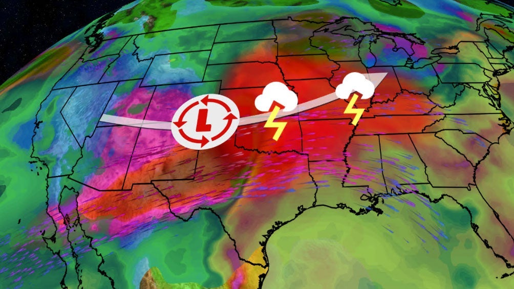
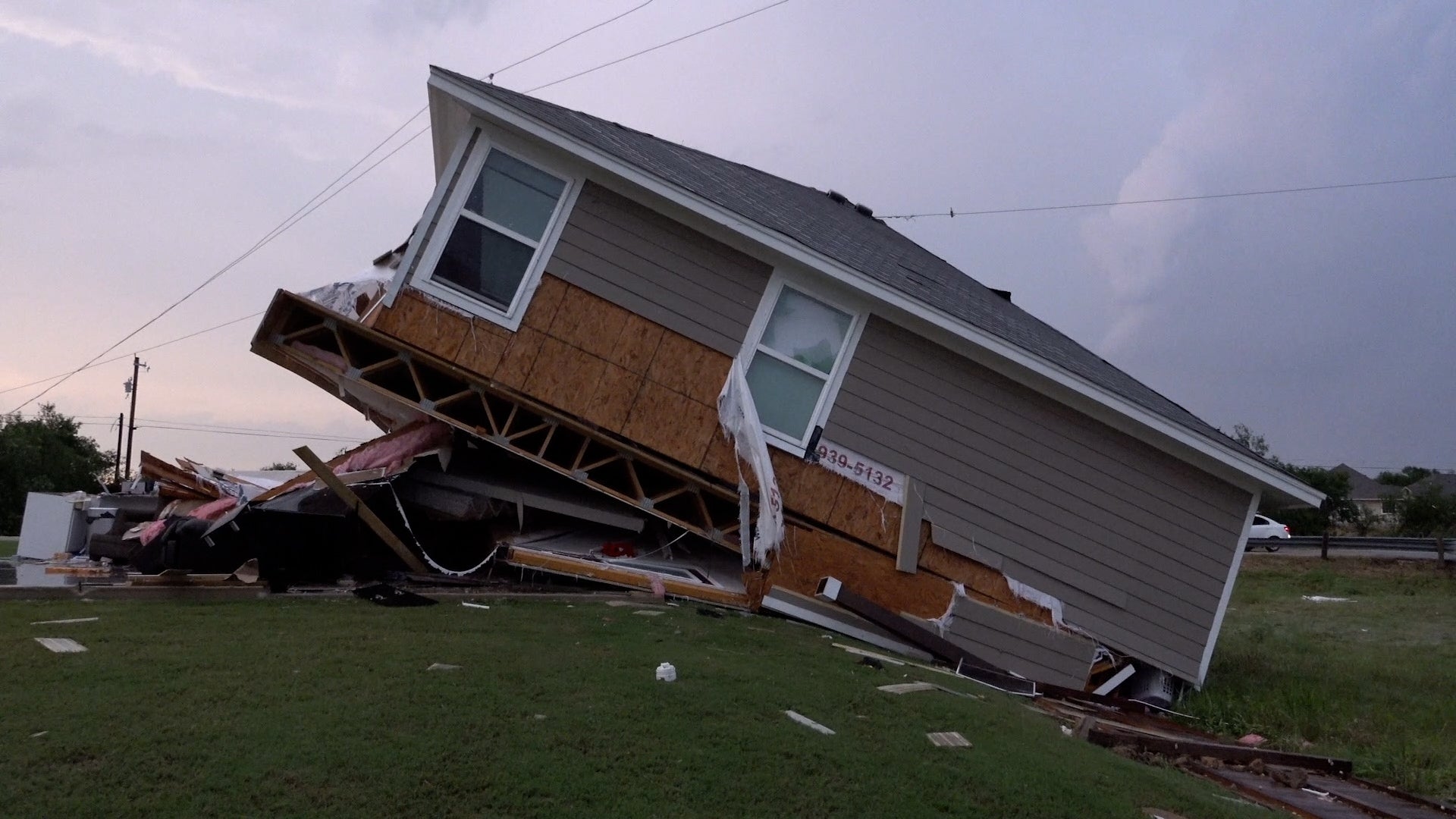
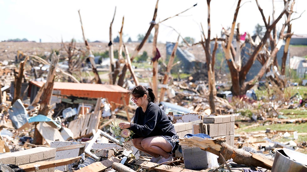
Torrey Pines, CA

6:03 AM PDT on May 25, 2012 (GMT -0700)
Elev: 259 ft
Lon: 117.2° W
Lat: 33.0° N
Source
Rapid Fire Updates™
Updated 5:20 AM PDT Get Free Weather Stickers® Share:
Your Custom Weather Sticker®

Copy the following lines of HTML:
Tropical Weather: Invest 94 (North Atlantic) Hurricane Bud (East Pacific) Typhoon Sanvu (Western Pacific)
Weather Summary
Weather Underground Forecast for Friday, May 25, 2012.

Expect more active weather to develop across the Great Lakes on Friday, as a low pressure system moves from the Upper Midwest into eastern Canada. This system will push a cold front over the Great Lakes and Midwest, producing scattered showers and thunderstorms throughout the day. There is a slight chance that some of these storms will turn severe with strong winds and large hail. Rainfall totals will range from 1 to 2 inches, with over 2 inches likely in areas of severe weather development.

Behind this activity in the West, a low pressure system will move over the Great Basin and into the Southern Rockies. Flow around this system will produce cooler temperatures across the West, while also triggering scattered showers over the Pacific Northwest, northern California, and Intermountain West. Snow showers may develop again across the highest elevations of the Northern Rockies.

Meanwhile in the East, high pressure builds from the Plains, over the Mississippi River Valley, and into the Eastern US. This will keep moisture away to the north, allowing for dry, sunny, and warm conditions. High temperatures will range in the 80s and 90s from the Central Plains through the Eastern Valleys, with parts of the Southern US reaching into the lower 100s.

Torrey Pines Weather at a Glance

Updated 5:20 AM PDT
Elevation
294 ft
Report Station
You are about to report this weather station for bad data.

Please select the information which is incorrect and click 'Submit' otherwise click 'Cancel'.

Cancel

Now
Light Drizzle
Light Drizzle Mist
Temperature
57 °F
Feels Like 57 °F
Wind(mph)
3
Sunrise / Set
5:43 AM
7:48 PM
Moon
Waxing Crescent
Today
Chance of Rain 66 °F
Chance of Rain
30% chance of precipitation
Tonight
Chance of Rain 54 °F
Chance of Rain
30% chance of precipitation
Tomorrow
Partly Cloudy 64 | 57 °F
Partly Cloudy
Sunday
Partly Cloudy 66 | 57 °F
Partly Cloudy
Monday
Partly Cloudy 70 | 57 °F
Partly Cloudy
Tuesday
Partly Cloudy 66 | 57 °F
Partly Cloudy
Today is forecast to be Cooler than yesterday.
Conditions
Pressure
29.72 in
Visibility
5.0 miles
Clouds
Overcast 800 ft
Moisture
Humidity
93%
Rainfall
-
Not available.
Snow Depth
Not available.
METAR
METAR KNKX 251255Z 19007KT 5SM -DZ BR OVC008 14/12 A2973 RMK AO2 CIG 004V011 SLP064 P0000 T01440122
Don't speak METAR? Read our FAQ.
Weather Radio
Temperature
Temperature
57 °F
Dew Point
55 °F
Wind
Speed / Dir
3 mph from SSE
Wind Gust
7.0 mph
Health
0 out of 16
Pollen
5.60 out of 12
Pollen Forecast
Ozone
Good
PM2.5
Good
Flu Activity
Local Activity
View Flu Map
Loading…
Source: BestForecast
Descriptive Forecast
Friday
chancerain Overcast with a chance of rain. High of 66F. Breezy. Winds from the SSW at 15 to 20 mph with gusts to 30 mph. Chance of rain 30%.
Friday Night
nt_chancerain Mostly cloudy with a chance of rain. Low of 54F. Breezy. Winds from the WSW at 10 to 20 mph. Chance of rain 30%.
Saturday
partlycloudy Mostly cloudy in the morning, then partly cloudy. High of 64F. Winds from the WSW at 10 to 15 mph.
Saturday Night
nt_mostlycloudy Mostly cloudy. Low of 57F. Winds from the North at 5 to 15 mph.
Sunday
partlycloudy Mostly cloudy in the morning, then clear. High of 66F. Winds from the North at 5 to 10 mph shifting to the WNW in the afternoon.
Sunday Night
nt_clear Partly cloudy. Fog overnight. Low of 57F. Winds from the NNW at 5 to 10 mph.
Monday
partlycloudy Clear. High of 70F. Winds from the West at 10 to 15 mph.
Monday Night
nt_clear Partly cloudy in the evening, then mostly cloudy. Fog overnight. Low of 57F. Winds less than 5 mph.
Tuesday
partlycloudy Mostly cloudy in the morning, then clear. High of 66F. Winds from the WSW at 5 to 15 mph.
Tuesday Night
nt_clear Clear. Fog overnight. Low of 57F. Winds less than 5 mph.
Wednesday
clear Clear. High of 66F. Winds from the West at 5 to 15 mph.
Wednesday Night
nt_clear Clear. Fog overnight. Low of 59F. Winds less than 5 mph.
Thursday
partlycloudy Clear. High of 66F. Winds from the West at 5 to 15 mph.
Thursday Night
nt_partlycloudy Partly cloudy. Fog overnight. Low of 57F. Winds less than 5 mph.
Friday
partlycloudy Clear. High of 68F. Winds from the West at 10 to 15 mph.
Friday Night
nt_clear Partly cloudy. Low of 57F. Winds less than 5 mph.
Saturday
partlycloudy Partly cloudy. High of 68F. Winds less than 5 mph.
Saturday Night
nt_clear Partly cloudy. Low of 57F. Winds less than 5 mph.
Sunday
partlycloudy Clear. High of 66F. Winds from the WSW at 5 to 10 mph.
Sunday Night
nt_clear Clear. Low of 55F. Winds less than 5 mph.
Monday
clear Clear. High of 66F. Winds from the WSW at 5 to 10 mph.
Monday Night
nt_clear Clear. Low of 55F. Winds less than 5 mph.
Loading…
 
First Previous Last Next  
Updated:  


Forecast

View Calendar 10-Day Forecast for station KCADELMA3

Friday, 25
Chance of Rain
66 | 54 °F
Chance of Rain
Chance of
Precipitation
30%
Saturday, 26
Partly Cloudy
64 | 57 °F
Partly Cloudy
Chance of
Precipitation
10%
Sunday, 27
Partly Cloudy
66 | 57 °F
Partly Cloudy
Chance of
Precipitation
0%
Monday, 28
Partly Cloudy
70 | 57 °F
Partly Cloudy
Chance of
Precipitation
0%
Tuesday, 29
Partly Cloudy
66 | 57 °F
Partly Cloudy
Chance of
Precipitation
0%
Wednesday, 30
Fog
66 | 59 °F
Fog
Chance of
Precipitation
0%
Thursday, 31
Partly Cloudy
66 | 57 °F
Partly Cloudy
Chance of
Precipitation
0%
Friday, 1
Partly Cloudy
68 | 57 °F
Partly Cloudy
Chance of
Precipitation
0%
Saturday, 2
Partly Cloudy
68 | 57 °F
Partly Cloudy
Chance of
Precipitation
0%
Sunday, 3
Partly Cloudy
66 | 55 °F
Partly Cloudy
Chance of
Precipitation
0%
Source: BestForecast at 1:14 AM PDT on May 25, 2012
Descriptive Forecast
Friday
chancerain Overcast with a chance of rain. High of 66F. Breezy. Winds from the SSW at 15 to 20 mph with gusts to 30 mph. Chance of rain 30%.
Friday Night
nt_chancerain Mostly cloudy with a chance of rain. Low of 54F. Breezy. Winds from the WSW at 10 to 20 mph. Chance of rain 30%.
Hourly Forecast 6AM 12 Noon 6PM 12 Midnight
Temp. | Dew Point 61 | 56 62 | 59 61 | 56 56 | 46
Wind 13 mph SSE 17 mph South 17 mph West 14 mph West
Humidity 87% 91% 81% 66%
Chance of Precip. 20% 20% 30% 30%
Cloud Cover 100% 94% 87% 77%
Conditions Chance of Rain Chance of Rain Chance of Rain Chance of Rain
Sunrise & Sunset
5:43 AM
7:48 PM
The quality of the forecasted high temperature for this day is fair. MaxT RMSE [2.99], Average RMSE [1.42]
The National Weather Service forecast quality is excellent. MaxT RMSE [1.36], Average RMSE [1.05] : Use NWS
Source: BestForecast at 1:14 AM PDT on May 25, 2012
Descriptive Forecast
Saturday
partlycloudy Mostly cloudy in the morning, then partly cloudy. High of 64F. Winds from the WSW at 10 to 15 mph.
Saturday Night
nt_mostlycloudy Mostly cloudy. Low of 57F. Winds from the North at 5 to 15 mph.
Hourly Forecast 6AM 12 Noon 6PM 12 Midnight
Temp. | Dew Point 56 | 51 63 | 55 63 | 53 58 | 53
Wind 10 mph WSW 12 mph WSW 13 mph WNW 6 mph North
Humidity 84% 74% 71% 82%
Chance of Precip. 10% 10% 10% 0%
Cloud Cover 78% 57% 62% 78%
Conditions Mostly Cloudy Partly Cloudy Partly Cloudy Mostly Cloudy
Sunrise & Sunset
5:43 AM
7:49 PM
The quality of the forecasted high temperature for this day is excellent. MaxT RMSE [1.29], Average RMSE [1.49]
The National Weather Service forecast quality is excellent. MaxT RMSE [1.40], Average RMSE [1.18] : Use NWS
Source: BestForecast at 1:14 AM PDT on May 25, 2012
Descriptive Forecast
Sunday
partlycloudy Mostly cloudy in the morning, then clear. High of 66F. Winds from the North at 5 to 10 mph shifting to the WNW in the afternoon.
Sunday Night
nt_clear Partly cloudy. Fog overnight. Low of 57F. Winds from the NNW at 5 to 10 mph.
Hourly Forecast 6AM 12 Noon 6PM 12 Midnight
Temp. | Dew Point 58 | 55 64 | 58 63 | 57 60 | 58
Wind 3 mph ENE 8 mph WNW 8 mph WNW 5 mph NNW
Humidity 87% 79% 80% 92%
Chance of Precip. 0% 0% 0% 0%
Cloud Cover 78% 19% 19% 0%
Conditions Mostly Cloudy Clear Clear Fog
Sunrise & Sunset
5:42 AM
7:49 PM
The quality of the forecasted high temperature for this day is excellent. MaxT RMSE [1.01], Average RMSE [1.08]
The National Weather Service forecast quality is excellent. MaxT RMSE [1.23], Average RMSE [1.29] : Use NWS
Source: BestForecast at 1:14 AM PDT on May 25, 2012
Descriptive Forecast
Monday
partlycloudy Clear. High of 70F. Winds from the West at 10 to 15 mph.
Monday Night
nt_clear Partly cloudy in the evening, then mostly cloudy. Fog overnight. Low of 57F. Winds less than 5 mph.
Hourly Forecast 6AM 12 Noon 6PM 12 Midnight
Temp. | Dew Point 60 | 57 65 | 60 65 | 58 59 | 58
Wind 3 mph North 12 mph West 9 mph West 2 mph West
Humidity 92% 80% 81% 96%
Chance of Precip. 0% 0% 0% 0%
Cloud Cover 0% 0% 0% 0%
Conditions Fog Clear Clear Fog
Sunrise & Sunset
5:42 AM
7:50 PM
The quality of the forecasted high temperature for this day is excellent. MaxT RMSE [1.00], Average RMSE [1.22]
The National Weather Service forecast quality is good. MaxT RMSE [1.83], Average RMSE [1.16] : Use NWS
Source: BestForecast at 1:14 AM PDT on May 25, 2012
Descriptive Forecast
Tuesday
partlycloudy Mostly cloudy in the morning, then clear. High of 66F. Winds from the WSW at 5 to 15 mph.
Tuesday Night
nt_clear Clear. Fog overnight. Low of 57F. Winds less than 5 mph.
Hourly Forecast 6AM 12 Noon 6PM 12 Midnight
Temp. | Dew Point 59 | 56 65 | 61 63 | 60 57 | 56
Wind 2 mph West 9 mph WSW 9 mph West 3 mph NW
Humidity 91% 84% 85% 93%
Chance of Precip. 0% 0% 0% 0%
Cloud Cover 83% 0% 0% 0%
Conditions Fog Clear Clear Fog
Sunrise & Sunset
5:42 AM
7:51 PM
The quality of the forecasted high temperature for this day is excellent. MaxT RMSE [0.99], Average RMSE [1.01]
The National Weather Service forecast quality is good. MaxT RMSE [2.01], Average RMSE [0.95] : Use NWS
Source: BestForecast at 1:14 AM PDT on May 25, 2012
Descriptive Forecast
Wednesday
clear Clear. High of 66F. Winds from the West at 5 to 15 mph.
Wednesday Night
nt_clear Clear. Fog overnight. Low of 59F. Winds less than 5 mph.
Hourly Forecast 6AM 12 Noon 6PM 12 Midnight
Temp. | Dew Point 58 | 57 64 | 60 64 | 62 58 | 56
Wind 3 mph NW 10 mph West 8 mph West 3 mph NW
Humidity 95% 87% 90% 95%
Chance of Precip. 0% 0% 0% 0%
Cloud Cover 41% 0% 0% 0%
Conditions Fog Clear Clear Fog
Sunrise & Sunset
5:42 AM
7:51 PM
The quality of the forecasted high temperature for this day is excellent. MaxT RMSE [1.12], Average RMSE [1.40]
The National Weather Service forecast quality is good. MaxT RMSE [1.96], Average RMSE [1.04] : Use NWS
Source: BestForecast at 1:14 AM PDT on May 25, 2012
Descriptive Forecast
Thursday
partlycloudy Clear. High of 66F. Winds from the West at 5 to 15 mph.
Thursday Night
nt_partlycloudy Partly cloudy. Fog overnight. Low of 57F. Winds less than 5 mph.
Hourly Forecast 6AM 12 Noon 6PM 12 Midnight
Temp. | Dew Point 60 | 58 64 | 62 63 | 62 60 | 60
Wind 2 mph WNW 10 mph WSW 7 mph West 2 mph NNW
Humidity 92% 91% 94% 100%
Chance of Precip. 0% 0% 0% 0%
Cloud Cover 21% 0% 0% 0%
Conditions Fog Clear Clear Fog
Sunrise & Sunset
5:42 AM
7:51 PM
The quality of the forecasted high temperature for this day is good. MaxT RMSE [1.68], Average RMSE [1.42]
Source: BestForecast at 1:14 AM PDT on May 25, 2012
Descriptive Forecast
Friday
partlycloudy Clear. High of 68F. Winds from the West at 10 to 15 mph.
Friday Night
nt_clear Partly cloudy. Low of 57F. Winds less than 5 mph.
Hourly Forecast 6AM 12 Noon 6PM 12 Midnight
Temp. | Dew Point 60 | 58 65 | 62 63 | 60 58 | 58
Wind 3 mph NW 11 mph WSW 7 mph WSW 2 mph SW
Humidity 94% 85% 90% 99%
Chance of Precip. 0% 0% 0% 0%
Cloud Cover 100% 0% 0% 14%
Conditions Fog Clear Clear Clear
Sunrise & Sunset
5:42 AM
7:51 PM
The quality of the forecasted high temperature for this day is good. MaxT RMSE [2.31], Average RMSE [1.88]
Source: BestForecast at 1:14 AM PDT on May 25, 2012
Descriptive Forecast
Saturday
partlycloudy Partly cloudy. High of 68F. Winds less than 5 mph.
Saturday Night
nt_clear Partly cloudy. Low of 57F. Winds less than 5 mph.
Hourly Forecast 6AM 12 Noon 6PM 12 Midnight
Temp. | Dew Point 60 | 58 65 | 62 63 | 62 58 | 55
Wind 2 mph WSW 4 mph SW 5 mph West 3 mph SW
Humidity 95% 85% 91% 91%
Chance of Precip. 0% 0% 0% 10%
Cloud Cover 29% 21% 13% 21%
Conditions Partly Cloudy Clear Clear Clear
Sunrise & Sunset
5:42 AM
7:51 PM
The quality of the forecasted high temperature for this day is fair. MaxT RMSE [2.83], Average RMSE [1.97]
Source: BestForecast at 1:14 AM PDT on May 25, 2012
Descriptive Forecast
Sunday
partlycloudy Clear. High of 66F. Winds from the WSW at 5 to 10 mph.
Sunday Night
nt_clear Clear. Low of 55F. Winds less than 5 mph.
Hourly Forecast 6AM 12 Noon 6PM 12 Midnight
Temp. | Dew Point 61 | 54 66 | 56 63 | 52 56 | 48
Wind 2 mph SW 4 mph SW 6 mph West 4 mph SW
Humidity 78% 70% 65% 71%
Chance of Precip. 10% 0% 0% 0%
Cloud Cover 28% 14% 0% 0%
Conditions Partly Cloudy Clear Clear Clear
Sunrise & Sunset
5:42 AM
7:51 PM
Source: BestForecast at 1:14 AM PDT on May 25, 2012
Descriptive Forecast
Monday
clear Clear. High of 66F. Winds from the WSW at 5 to 10 mph.
Monday Night
nt_clear Clear. Low of 55F. Winds less than 5 mph.
Hourly Forecast 6AM 12 Noon 6PM 12 Midnight
Temp. | Dew Point 59 | 51 64 | 54 64 | 51 56 | 46
Wind 3 mph SW 4 mph SW 6 mph West 3 mph WSW
Humidity 75% 67% 62% 71%
Chance of Precip. 0% 0% 0% 0%
Cloud Cover 0% 0% 0% %
Conditions Clear Clear Clear Clear
Sunrise & Sunset
5:42 AM
7:51 PM
Nearby
History & Almanac
May 25, 2012 Max Temp Min Temp
Normal (KNKX) 70 °F 53 °F
Record (KNKX) 76 °F (2003) 46 °F (2008)
Choose a date
Earthquake Activity
City Distance Mag. Time & Date
Calexico, CA 92 miles 2.5 11:58 PM PDT
2012-05-24
Guadalupe Victoria, Mexico 126 miles 2.7 11:05 PM PDT
2012-05-23
Barstow, CA 140 miles 3.2 10:45 PM PDT
2012-05-23
Guadalupe Victoria, Mexico 126 miles 2.6 1:36 PM PDT
2012-05-23
Minimum magnitude displayed is 2.5.
Air Quality
  Air Quality AQ Index Pollutant
Yesterday Moderate
PM2.5
Yesterday Good
OZONE
Current Good
PM2.5
Current Good
OZONE
Friday Good
PM2.5
Friday Good
OZONE
Coastal Water Temperatures
Place Temperature
La Jolla, CA 64.9 °F
San Diego, CA 66.9 °F
Astronomy
May. 25, 2012 Rise Set
Actual Time 5:43 AM PDT 7:48 PM PDT
Civil Twilight 5:15 AM PDT 8:16 PM PDT
Nautical Twilight 4:41 AM PDT 8:50 PM PDT
Astronomical Twilight 4:05 AM PDT 9:27 PM PDT
Moon 9:43 AM PDT 11:33 PM PDT
Length Of Visible Light 15h 00m
Length of Day
14h 04m
Tomorrow will be 1m 3s longer.
Waxing Crescent, 18% of the Moon is Illuminated
Today
Waxing Crescent
May 28
First Quarter
Jun 4
Full
Jun 11
Last Quarter
Jun 19
New
Today's Extremes
State Highs State Lows
82 °F
Needles
75 °F
Blythe
72 °F
Palm Springs
72 °F
Thermal
32 °F
Truckee-Tahoe
32 °F
Weaverville
33 °F
Blue Canyon
35 °F
Alturas
35 °F
Mount Shasta
Snow Depth
Station Depth Elevation
Leavitt Lake 19 in 9400 ft
Leavitt Meadows 1 in 7200 ft
Sonora Pass 0 in 8800 ft
Summit Meadow 2 in 9122 ft
Poison Flat 0 in 7900 ft
WunderPhotos®
Mars Rover Opportunity Captures Its Shadow
Florida Flooding
Uploaded by: apphotos
1,495,723 photos uploaded!
WunderBlogs®
Beautiful Spring day
By WatchinTheSky 1 day ago
Travel & Activities
Travel Planning
Destination? *
When are you going?
to
Is there an activity you would like to explore?
* Required field
Nearby Events
Event Date Forecast
Dale Hauskins 6:00 PM PDT 2012-05-25 Chance of Rain, 61°F
Unwritten Law 8:00 PM PDT 2012-05-25 Chance of Rain, 57°F
Gone Soft Tour 9:00 PM PDT 2012-05-25 Chance of Rain, 56°F
FORE Friday - Golf Networking for Real Estate & Business Professionals 7:00 AM PDT 2012-05-25 Chance of Rain, 61°F
Bootstrappers Breakfast - San Diego 7:00 AM PDT 2012-05-25 Chance of Rain, 61°F
Exceptional Entrepreneurs Business Networking Del Mar 11:00 AM PDT 2012-05-25 Chance of Rain, 63°F
Event data courtesy eviesays.com
Aviation
City Temp. Conditions Updated
Miramar MCAS 58 °F Light Drizzle Mist 5:55 AM PDT
San Diego Montgomery 57 °F Overcast 5:53 AM PDT
Carlsbad 59 °F Overcast 5:53 AM PDT
San Diego 60 °F Overcast 5:51 AM PDT
Flight To ETA Status
SWA103
Denver, CO
KSAN 07:56AM On Time
AWE162
Charlotte, NC
KSAN 09:30AM On Time
DAL1692
Atlanta, GA
KSAN 09:49AM On Time
AWE153
Philadelphia, PA
KSAN 09:51AM On Time
Flight Tracker by FlightAware FlightAware
Type Condition
Flight Rule: IFR (KNKX)
Wind Speed: 7.0 kts.
Wind Dir: 152° (SSE)
Ceiling: 800 ft

METAR KNKX 251255Z 19007KT 5SM -DZ BR OVC008 14/12 A2973 RMK AO2 CIG 004V011 SLP064 P0000 T01440122

Sports
Event Date Forecast
Royals vs. Orioles 7:05 PM EDT on May 25, 2012 Clear, 79 °F
Cubs vs. Pirates 7:05 PM EDT on May 25, 2012 Chance of a Thunderstorm, 81 °F
Diamondbacks vs. Padres 7:05 PM PDT on June 01, 2012 Average High 70° F/ 21° C
Diamondbacks vs. Padres 4:15 PM PDT on June 02, 2012 Average High 69° F/ 20° C
Event Date Forecast
Athletic vs. Barcelona 12:00 PM CEST on May 25, 2012 Scattered Clouds, High 86° F/ 30° C
Barcelona vs. Athletic 10:00 PM CEST on May 25, 2012 Scattered Clouds, High 86° F/ 30° C
Event Date Forecast
Coca-Cola 600 6:16 PM EDT on May 27, 2012 Chance of a Thunderstorm, 81 °F
FedEx 400 benefiting Autism Speaks 1:15 PM EDT on June 03, 2012 Average High 79° F/ 26° C
Event Date Forecast
Crowne Plaza Invitational at Colonial 8:30 AM CDT on May 25, 2012 Overcast, 74 °F
Crowne Plaza Invitational at Colonial 8:30 AM CDT on May 26, 2012 Mostly Cloudy, 72 °F
Weather Stations
Station Location Temp. Dew Point Humidity Wind Precipitation Elevation Updated Type Website
MesoWest Del Mar Heights , Del Mar, CA 57 °F 55 °F 93% SSE  at  3 mph 0.00 in / hr 294 ft 5:20 AM PDT MADIS
Del Mar Heights, Del Mar, CA 57.5 °F 56 °F 95% SSW  at  2.0 mph 0.00 in / hr 240 ft 6:02 AM PDT Rapid Fire
MesoWest Del Mar SE1 , Del Mar, CA 58 °F 57 °F 95% West  at  5 mph 0.01 in / hr 294 ft 4:55 AM PDT MADIS
Senterra, Villages of Fairbanks, San Diego, CA 57.8 °F 57 °F 97% ENE  at  0.0 mph 0.01 in / hr 250 ft 6:03 AM PDT Rapid Fire  
MesoWest Del Mar-Mira Costa College , Del Mar, CA - - - SSE  at  4 mph 0.00 in / hr 115 ft 4:00 AM PDT MADIS
Del Mar Coastal, Del Mar, CA 58.1 °F 56 °F 93% SE  at  5.0 mph 0.00 in / hr 152 ft 6:03 AM PDT Rapid Fire  
Solana Beach, Solana Beach, CA 57.4 °F 56 °F 95% SSW  at  1.0 mph 0.00 in / hr 198 ft 6:03 AM PDT Rapid Fire
Torrey Pines Reserve, San Diego, CA 57.0 °F 54 °F 91% North  at  0.0 mph 0.00 in / hr 347 ft 6:00 AM PDT Rapid Fire
Torrey Highlands, San Diego, CA 58.3 °F 55 °F 90% SE  at  3.9 mph - / hr 330 ft 6:03 AM PDT Normal  
Los Penasquitos Canyon, San Diego, CA 58.2 °F 56 °F 92% SSE  at  1.0 mph 0.00 in / hr 314 ft 6:03 AM PDT Rapid Fire  
Mira Mesa, San Diego, CA 58.3 °F 41 °F 53% SE  at  2.2 mph 0.00 in / hr 406 ft 6:03 AM PDT Rapid Fire  
APRSWXNET Cardiff By The Sea CA , Cardiff By The Sea, CA 58 °F 55 °F 91% SE  at  2 mph 0.01 in / hr 298 ft 5:27 AM PDT MADIS
Olivenhain, Encinitas, CA 58.7 °F 57 °F 94% SSE  at  0.0 mph 0.00 in / hr 20 ft 6:01 AM PDT Rapid Fire  
APRSWXNET Torrey Pines Glider CA , La Jolla, CA 57 °F - - SW  at  4 mph 0.00 in / hr 370 ft 5:34 AM PDT MADIS
Rancho Penasquitos - Northwest, San Diego, CA 57.9 °F 54 °F 86% SSE  at  3.1 mph 0.00 in / hr 460 ft 6:01 AM PDT Rapid Fire
UCSD Field Station, La Jolla, CA 57.5 °F 55 °F 92% South  at  1.0 mph 0.00 in / hr 298 ft 6:00 AM PDT Normal  
Encinitas, CA 58.8 °F 54 °F 84% NNE  at  0.0 mph 0.02 in / hr 350 ft 6:03 AM PDT Rapid Fire
MesoWest Rancho Santa Fe , Rancho Santa Fe, CA 58 °F 58 °F 100% SSE  at  1 mph 0.00 in / hr 249 ft 5:20 AM PDT MADIS
Cerros Redondos, Rancho Santa Fe, CA 57.5 °F 56 °F 95% South  at  0.0 mph 0.00 in / hr 243 ft 6:02 AM PDT Rapid Fire  
Rancho Penasquitos South, San Diego, CA 57.9 °F 55 °F 91% North  at  - 0.00 in / hr 600 ft 6:00 AM PDT Normal  
Mira Mesa, CA 58.1 °F 54 °F 88% South  at  2.0 mph 0.00 in / hr 410 ft 5:57 AM PDT Normal  
R. Penasquitos - Black Mtn., San Diego, CA 57.7 °F 57 °F 99% SW  at  0.0 mph 0.01 in / hr 719 ft 6:03 AM PDT Rapid Fire  
Olivenhain, Encinitas, CA 58.8 °F 57 °F 92% SW  at  0.0 mph - / hr 223 ft 5:56 AM PDT Normal
Mira Mesa, San Diego, CA 57.4 °F 54 °F 89% WSW  at  2.5 mph 0.00 in / hr 428 ft 6:03 AM PDT Rapid Fire  
MesoWest La Jolla , La Jolla, CA 58 °F 56 °F 93% South  at  2 mph 0.00 in / hr 180 ft 4:45 AM PDT MADIS
Scripps Pier (La Jolla), La Jolla, CA 58.5 °F 61 °F 91% South  at  8.8 mph 0.00 in / hr 40 ft 5:49 AM PDT Normal
La Jolla Shores, La Jolla, CA 62.7 °F 61 °F 92% South  at  8.8 mph 0.00 in / hr 50 ft 6:00 AM PDT Normal
Calle Acervo/Rancho Santa Fe Rd, Carlsbad, CA 59.0 °F 57 °F 93% NE  at  0.0 mph 0.00 in / hr 171 ft 5:55 AM PDT Normal  
Would you like to share your weather data with the rest of the world? Add Your Weather Station!