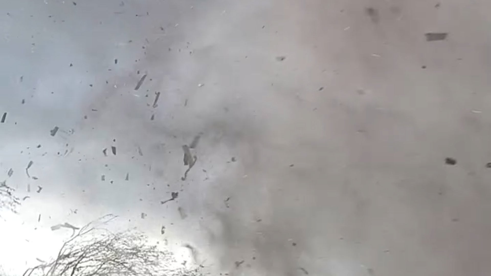
Campo, CA

4:36 PM PDT on May 24, 2012 (GMT -0700)
Elev: 3025 ft
Lon: 116.5° W
Lat: 32.7° N
Source
Rapid Fire Updates™
Updated 4:00 PM PDT Get Free Weather Stickers® Share:
Your Custom Weather Sticker®

Copy the following lines of HTML:
Tropical Weather: Invest 94 (North Atlantic) Hurricane Bud (East Pacific) Typhoon Sanvu (Western Pacific)
Weather Summary
Weather Underground midday recap for Thursday, May 24, 2012.

Severe weather developed over the North Central US on Thursday, as a low pressure system moved over the Upper Midwest. This created a frontal boundary that stretched from the Great Lakes through the Central Plains and produced moderate to heavy showers and thunderstorms. These storms produced heavy rainfall and strong winds for Minnesota and western Wisconsin. Rainfall totals ranged around 2 inches across the region, with heaviest rainfall reported in Minneapolis, Minnesota with a mid-day total of 2.10 inches. Flood advisories have been issued across the Upper Midwest due to this low moving frontal boundary. Meanwhile, the back side of this system allowed for another front to linger over the Northern Rockies. This system stretched into the Pacific Northwest and produced scattered showers throughout the day. Cooler temperatures over Northern Rockies allowed for snow showers to develop at the highest elevations in western Montana and northwestern Wyoming.

South of this activity, winds increased over the Southwest as a trough of low pressure moved in from the west. This created another warm and dry day for Arizona, New Mexico, and the Great Basin, which kept fire danger high.

In the East, heavy rainfall and strong winds associated with thunderstorm activity continued over southern Florida and the Bahamas. To the north, however, lighter and more widespread showers persisted in the Northeast and Mid-Atlantic states as a frontal boundary stalled over the region.

Campo Weather at a Glance

Updated 4:00 PM PDT
Elevation
3084 ft
Report Station
You are about to report this weather station for bad data.

Please select the information which is incorrect and click 'Submit' otherwise click 'Cancel'.

Cancel

Now
Scattered Clouds
Scattered Clouds
Temperature
69 °F
Feels Like 69 °F
Wind(mph)
10
Sunrise / Set
5:41 AM
7:44 PM
Moon
Waxing Crescent
Tonight
Partly Cloudy 48 °F
Partly Cloudy
Tomorrow
Chance of Rain 68 °F
Chance of Rain
20% chance of precipitation
Tomorrow Night
Chance of Rain 39 °F
Chance of Rain
30% chance of precipitation
Saturday
Chance of Rain 63 | 41 °F
Chance of Rain
20% chance of precipitation
Sunday
Partly Cloudy 72 | 43 °F
Partly Cloudy
Monday
Clear 81 | 37 °F
Clear
Tomorrow is forecast to be Much Cooler than today.
Conditions
Pressure
29.69 in
Visibility
10.0 miles
Clouds
Scattered Clouds 3000 ft
Moisture
Humidity
56%
Rainfall
-
Not available.
Snow Depth
Not available.
METAR
METAR KRNM 242253Z 27009G15KT 10SM SCT030 21/12 A2969 RMK AO2 SLPNO T02060122
Don't speak METAR? Read our FAQ.
Weather Radio
Temperature
Temperature
69 °F
Dew Point
53 °F
Wind
Speed / Dir
10 mph from West
Wind Gust
15.0 mph
Health
5 out of 16
Pollen
5.20 out of 12
Pollen Forecast
Air Quality
Not available.
Flu Activity
Local Activity
View Flu Map
Loading…
Source: BestForecast
Descriptive Forecast
Thursday Night
nt_partlycloudy Partly cloudy in the evening, then overcast. Fog overnight. Low of 48F. Winds from the SSW at 5 to 15 mph.
Friday
chancerain Overcast in the morning, then partly cloudy with a chance of rain. Fog early. High of 68F. Breezy. Winds from the SW at 15 to 20 mph with gusts to 30 mph. Chance of rain 20%.
Friday Night
nt_chancerain Mostly cloudy with a chance of rain. Low of 39F. Breezy. Winds from the WSW at 15 to 25 mph with gusts to 30 mph. Chance of rain 30%.
Saturday
chancerain Partly cloudy with a chance of rain. High of 63F. Winds from the West at 10 to 15 mph. Chance of rain 20%.
Saturday Night
nt_partlycloudy Partly cloudy. Fog overnight. Low of 41F. Winds from the WSW at 5 to 10 mph.
Sunday
partlycloudy Clear. High of 72F. Winds less than 5 mph.
Sunday Night
nt_clear Clear. Low of 43F. Winds less than 5 mph.
Monday
clear Clear. High of 81F. Winds from the WNW at 5 to 10 mph.
Monday Night
nt_clear Clear. Low of 37F. Winds from the WSW at 5 to 10 mph.
Tuesday
clear Clear. High of 82F. Winds from the WSW at 5 to 15 mph.
Tuesday Night
nt_clear Clear. Low of 43F. Winds from the WSW at 5 to 10 mph.
Wednesday
clear Clear. High of 82F. Winds from the West at 5 to 10 mph.
Wednesday Night
nt_clear Clear. Low of 46F. Winds from the WSW at 5 to 10 mph.
Thursday
clear Clear. High of 81F. Winds from the West at 5 to 15 mph.
Thursday Night
nt_clear Clear. Low of 43F. Winds from the WSW at 5 to 10 mph.
Friday
clear Clear. High of 88F. Winds less than 5 mph.
Friday Night
nt_clear Partly cloudy. Low of 48F. Winds less than 5 mph.
Saturday
partlycloudy Partly cloudy. High of 88F. Winds less than 5 mph.
Saturday Night
nt_partlycloudy Partly cloudy. Low of 46F. Winds less than 5 mph.
Sunday
partlycloudy Partly cloudy. High of 86F. Winds from the SW at 5 to 10 mph.
Sunday Night
nt_partlycloudy Partly cloudy. Low of 46F. Winds from the WSW at 5 to 10 mph.
Loading…
 
First Previous Last Next  
Updated:  


Nowcast
Wind Advisory in effect until 11 am PDT Friday...
High Wind Warning in effect from 11 am Friday to 4 am PDT Saturday...
webcam preview

Forecast

View Calendar 10-Day Forecast for station KCZZ

Thursday, 24
Clear
77 | 48 °F
Clear
Chance of
Precipitation
10%
Friday, 25
Chance of Rain
68 | 39 °F
Chance of Rain
Chance of
Precipitation
20%
Saturday, 26
Chance of Rain
63 | 41 °F
Chance of Rain
Chance of
Precipitation
20%
Sunday, 27
Partly Cloudy
72 | 43 °F
Partly Cloudy
Chance of
Precipitation
0%
Monday, 28
Clear
81 | 37 °F
Clear
Chance of
Precipitation
0%
Tuesday, 29
Clear
82 | 43 °F
Clear
Chance of
Precipitation
0%
Wednesday, 30
Clear
82 | 46 °F
Clear
Chance of
Precipitation
0%
Thursday, 31
Clear
81 | 43 °F
Clear
Chance of
Precipitation
0%
Friday, 1
Clear
88 | 48 °F
Clear
Chance of
Precipitation
0%
Saturday, 2
Partly Cloudy
88 | 46 °F
Partly Cloudy
Chance of
Precipitation
0%
Source: BestForecast at 3:15 PM PDT on May 24, 2012
Descriptive Forecast
Thursday Night
nt_partlycloudy Partly cloudy in the evening, then overcast. Fog overnight. Low of 48F. Winds from the SSW at 5 to 15 mph.
Hourly Forecast 6AM 12 Noon 6PM 12 Midnight
Temp. | Dew Point 48 | 41 73 | 47 66 | 51 51 | 51
Wind 3 mph ESE 11 mph SW 13 mph WSW 4 mph SSE
Humidity 81% 40% 61% 100%
Chance of Precip. 0% 0% 0% 10%
Cloud Cover 3% 4% 0% 53%
Conditions Clear Clear Clear Fog
Sunrise & Sunset
5:41 AM
7:44 PM
The quality of the forecasted high temperature for this day is excellent. MaxT RMSE [1.15], Average RMSE [1.66]
The National Weather Service forecast quality is good. MaxT RMSE [1.90], Average RMSE [2.45] : Use NWS
Source: BestForecast at 3:15 PM PDT on May 24, 2012
Descriptive Forecast
Friday
chancerain Overcast in the morning, then partly cloudy with a chance of rain. Fog early. High of 68F. Breezy. Winds from the SW at 15 to 20 mph with gusts to 30 mph. Chance of rain 20%.
Friday Night
nt_chancerain Mostly cloudy with a chance of rain. Low of 39F. Breezy. Winds from the WSW at 15 to 25 mph with gusts to 30 mph. Chance of rain 30%.
Hourly Forecast 6AM 12 Noon 6PM 12 Midnight
Temp. | Dew Point 51 | 50 64 | 45 57 | 52 46 | 44
Wind 7 mph SW 18 mph SW 20 mph WSW 19 mph West
Humidity 97% 51% 82% 93%
Chance of Precip. 10% 10% 20% 20%
Cloud Cover 96% 60% 62% 82%
Conditions Fog Partly Cloudy Chance of Rain Chance of Rain
Sunrise & Sunset
5:41 AM
7:45 PM
The quality of the forecasted high temperature for this day is good. MaxT RMSE [1.91], Average RMSE [1.81]
The National Weather Service forecast quality is good. MaxT RMSE [2.48], Average RMSE [2.83] : Use NWS
Source: BestForecast at 3:15 PM PDT on May 24, 2012
Descriptive Forecast
Saturday
chancerain Partly cloudy with a chance of rain. High of 63F. Winds from the West at 10 to 15 mph. Chance of rain 20%.
Saturday Night
nt_partlycloudy Partly cloudy. Fog overnight. Low of 41F. Winds from the WSW at 5 to 10 mph.
Hourly Forecast 6AM 12 Noon 6PM 12 Midnight
Temp. | Dew Point 45 | 42 60 | 44 58 | 41 44 | 42
Wind 10 mph WSW 11 mph West 11 mph WNW 6 mph WSW
Humidity 91% 54% 57% 96%
Chance of Precip. 30% 10% 10% 0%
Cloud Cover 64% 41% 41% 0%
Conditions Chance of Rain Partly Cloudy Partly Cloudy Clear
Sunrise & Sunset
5:40 AM
7:45 PM
The quality of the forecasted high temperature for this day is fair. MaxT RMSE [2.61], Average RMSE [1.62]
The National Weather Service forecast quality is fair. MaxT RMSE [2.99], Average RMSE [2.87] : Use NWS
Source: BestForecast at 3:15 PM PDT on May 24, 2012
Descriptive Forecast
Sunday
partlycloudy Clear. High of 72F. Winds less than 5 mph.
Sunday Night
nt_clear Clear. Low of 43F. Winds less than 5 mph.
Hourly Forecast 6AM 12 Noon 6PM 12 Midnight
Temp. | Dew Point 47 | 44 69 | 34 67 | 45 50 | 48
Wind 2 mph West 3 mph NE 5 mph NW 3 mph NW
Humidity 91% 28% 45% 90%
Chance of Precip. 0% 0% 0% 0%
Cloud Cover 14% 0% 0% 0%
Conditions Fog Clear Clear Clear
Sunrise & Sunset
5:40 AM
7:46 PM
The quality of the forecasted high temperature for this day is fair. MaxT RMSE [2.66], Average RMSE [1.66]
The National Weather Service forecast quality is poor. MaxT RMSE [3.96], Average RMSE [2.70] : Use NWS
Source: BestForecast at 3:15 PM PDT on May 24, 2012
Descriptive Forecast
Monday
clear Clear. High of 81F. Winds from the WNW at 5 to 10 mph.
Monday Night
nt_clear Clear. Low of 37F. Winds from the WSW at 5 to 10 mph.
Hourly Forecast 6AM 12 Noon 6PM 12 Midnight
Temp. | Dew Point 48 | 43 78 | 41 72 | 47 49 | 42
Wind 2 mph NW 3 mph West 9 mph West 5 mph WSW
Humidity 83% 26% 42% 78%
Chance of Precip. 0% 0% 0% 0%
Cloud Cover 0% 0% 0% 0%
Conditions Clear Clear Clear Clear
Sunrise & Sunset
5:40 AM
7:46 PM
The quality of the forecasted high temperature for this day is good. MaxT RMSE [2.30], Average RMSE [2.13]
The National Weather Service forecast quality is poor. MaxT RMSE [4.67], Average RMSE [2.54] : Use NWS
Source: BestForecast at 3:15 PM PDT on May 24, 2012
Descriptive Forecast
Tuesday
clear Clear. High of 82F. Winds from the WSW at 5 to 15 mph.
Tuesday Night
nt_clear Clear. Low of 43F. Winds from the WSW at 5 to 10 mph.
Hourly Forecast 6AM 12 Noon 6PM 12 Midnight
Temp. | Dew Point 46 | 39 79 | 40 68 | 47 49 | 45
Wind 4 mph WSW 8 mph WSW 10 mph West 5 mph WSW
Humidity 77% 24% 48% 84%
Chance of Precip. 0% 0% 0% 0%
Cloud Cover 0% 0% 0% 0%
Conditions Clear Clear Clear Clear
Sunrise & Sunset
5:40 AM
7:46 PM
The quality of the forecasted high temperature for this day is poor. MaxT RMSE [3.63], Average RMSE [2.37]
The National Weather Service forecast quality is poor. MaxT RMSE [5.12], Average RMSE [2.77] : Use NWS
Source: BestForecast at 3:15 PM PDT on May 24, 2012
Descriptive Forecast
Wednesday
clear Clear. High of 82F. Winds from the West at 5 to 10 mph.
Wednesday Night
nt_clear Clear. Low of 46F. Winds from the WSW at 5 to 10 mph.
Hourly Forecast 6AM 12 Noon 6PM 12 Midnight
Temp. | Dew Point 50 | 41 79 | 38 74 | 49 47 | 42
Wind 4 mph WSW 7 mph West 9 mph West 5 mph WSW
Humidity 74% 22% 43% 81%
Chance of Precip. 0% 0% 0% 0%
Cloud Cover 0% 0% 0% 0%
Conditions Clear Clear Clear Clear
Sunrise & Sunset
5:40 AM
7:46 PM
The quality of the forecasted high temperature for this day is poor. MaxT RMSE [3.99], Average RMSE [2.78]
Source: BestForecast at 3:15 PM PDT on May 24, 2012
Descriptive Forecast
Thursday
clear Clear. High of 81F. Winds from the West at 5 to 15 mph.
Thursday Night
nt_clear Clear. Low of 43F. Winds from the WSW at 5 to 10 mph.
Hourly Forecast 6AM 12 Noon 6PM 12 Midnight
Temp. | Dew Point 51 | 41 80 | 45 73 | 50 53 | 49
Wind 4 mph WSW 7 mph West 10 mph West 5 mph WSW
Humidity 71% 27% 46% 88%
Chance of Precip. 0% 0% 0% 0%
Cloud Cover 0% 0% 0% 0%
Conditions Clear Clear Clear Clear
Sunrise & Sunset
5:40 AM
7:46 PM
The quality of the forecasted high temperature for this day is poor. MaxT RMSE [4.31], Average RMSE [3.15]
Source: BestForecast at 3:15 PM PDT on May 24, 2012
Descriptive Forecast
Friday
clear Clear. High of 88F. Winds less than 5 mph.
Friday Night
nt_clear Partly cloudy. Low of 48F. Winds less than 5 mph.
Hourly Forecast 6AM 12 Noon 6PM 12 Midnight
Temp. | Dew Point 51 | 45 84 | 49 77 | 62 55 | 48
Wind 4 mph WSW 2 mph South 4 mph WSW 4 mph WSW
Humidity 79% 29% 59% 78%
Chance of Precip. 0% 0% 0% 10%
Cloud Cover 0% 2% 5% 18%
Conditions Clear Clear Clear Clear
Sunrise & Sunset
5:40 AM
7:46 PM
The quality of the forecasted high temperature for this day is poor. MaxT RMSE [4.50], Average RMSE [3.45]
Source: BestForecast at 3:15 PM PDT on May 24, 2012
Descriptive Forecast
Saturday
partlycloudy Partly cloudy. High of 88F. Winds less than 5 mph.
Saturday Night
nt_partlycloudy Partly cloudy. Low of 46F. Winds less than 5 mph.
Hourly Forecast 6AM 12 Noon 6PM 12 Midnight
Temp. | Dew Point 53 | 43 81 | 67 75 | 60 54 | 44
Wind 3 mph WSW 4 mph South 6 mph WSW 5 mph WSW
Humidity 69% 61% 56% 65%
Chance of Precip. 10% 10% 10% 10%
Cloud Cover 32% 28% 23% 33%
Conditions Partly Cloudy Partly Cloudy Clear Partly Cloudy
Sunrise & Sunset
5:40 AM
7:46 PM
Source: BestForecast at 3:15 PM PDT on May 24, 2012
Descriptive Forecast
Sunday
partlycloudy Partly cloudy. High of 86F. Winds from the SW at 5 to 10 mph.
Sunday Night
nt_partlycloudy Partly cloudy. Low of 46F. Winds from the WSW at 5 to 10 mph.
Hourly Forecast 6AM 12 Noon 6PM 12 Midnight
Temp. | Dew Point 53 | 43 82 | 69 73 | 60 53 | 42
Wind 3 mph WSW 4 mph SSW 7 mph WSW 5 mph WSW
Humidity 71% 65% 60% 66%
Chance of Precip. 10% 10% 10% 10%
Cloud Cover 42% 36% 30% 37%
Conditions Partly Cloudy Partly Cloudy Partly Cloudy Partly Cloudy
Sunrise & Sunset
5:40 AM
7:46 PM
Source: BestForecast at 3:15 PM PDT on May 24, 2012
Descriptive Forecast
Hourly Forecast 6AM 12 Noon 6PM 12 Midnight
Temp. | Dew Point 51 | 41 81 | 67 73 | 60 -9998 | -9998
Wind 4 mph WSW 4 mph SW 7 mph WSW -9998 mph North
Humidity 71% 64% 60% 66%
Chance of Precip. 10% 0% 10% 0%
Cloud Cover 44% % 30% %
Conditions Partly Cloudy Clear Partly Cloudy Clear
Sunrise & Sunset
5:40 AM
7:46 PM
Nearby
History & Almanac
May 24, 2012 Max Temp Min Temp
Normal (KCZZ) 80 °F 42 °F
Record (KCZZ) 92 °F (1984) 26 °F (2010)
Yesterday 77 °F 44 °F
Yesterday's Heating Degree Days: 4
Choose a date
Earthquake Activity
City Distance Mag. Time & Date
Guadalupe Victoria, Mexico 81 miles 2.7 11:05 PM PDT
2012-05-23
Guadalupe Victoria, Mexico 88 miles 2.5 7:05 PM PDT
2012-05-23
Guadalupe Victoria, Mexico 80 miles 2.6 1:36 PM PDT
2012-05-23
Seeley, CA 47 miles 4.0 8:06 AM PDT
2012-05-22
Minimum magnitude displayed is 2.5.
Astronomy
May. 24, 2012 Rise Set
Actual Time 5:41 AM PDT 7:44 PM PDT
Civil Twilight 5:14 AM PDT 8:12 PM PDT
Nautical Twilight 4:40 AM PDT 8:45 PM PDT
Astronomical Twilight 4:04 AM PDT 9:22 PM PDT
Moon 8:44 AM PDT 10:50 PM PDT
Length Of Visible Light 14h 58m
Length of Day
14h 02m
Tomorrow will be 1m 6s longer.
Waxing Crescent, 14% of the Moon is Illuminated
Today
Waxing Crescent
May 28
First Quarter
Jun 4
Full
Jun 11
Last Quarter
Jun 19
New
Today's Extremes
State Highs State Lows
99 °F
Needles
97 °F
Thermal
96 °F
Blythe
95 °F
El Centro
95 °F
Palm Springs
24 °F
Truckee-Tahoe
30 °F
Alturas
35 °F
Weaverville
37 °F
Campo
Snow Depth
Station Depth Elevation
Leavitt Lake 18 in 9400 ft
Leavitt Meadows 1 in 7200 ft
Summit Meadow 1 in 9122 ft
Monitor Pass 0 in 8350 ft
Blue Lakes 0 in 8000 ft
WunderPhotos®
Mars Rover Opportunity Captures Its Shadow
Florida Flooding
Uploaded by: apphotos
1,495,607 photos uploaded!
WunderBlogs®
Beautiful Spring day
By WatchinTheSky 21 hours ago
Travel & Activities
Travel Planning
Destination? *
When are you going?
to
Is there an activity you would like to explore?
* Required field
Nearby Events
Event Date Forecast
No events within 10 mi of location. View all events.
Event data courtesy eviesays.com
Aviation
City Temp. Conditions Updated
Campo 72 °F N/A 3:52 PM PDT
Santee This station is not reporting.
San Diego Brown 68 °F Scattered Clouds 3:53 PM PDT
Ramona 69 °F Scattered Clouds 3:53 PM PDT
Flight To ETA Status
No flights were found.
Flight Tracker by FlightAware FlightAware
Type Condition
Flight Rule: VFR (KRNM)
Wind Speed: 9.0 kts.
Wind Dir: 260° (West)
Ceiling: Unlimited

METAR KRNM 242253Z 27009G15KT 10SM SCT030 21/12 A2969 RMK AO2 SLPNO T02060122

Sports
Event Date Forecast
Braves vs. Reds 7:10 PM EDT on May 24, 2012 Clear, 81 °F
Padres vs. Mets 7:10 PM EDT on May 24, 2012 Chance of a Thunderstorm, 65 °F
Diamondbacks vs. Padres 7:05 PM PDT on June 01, 2012 Average High 70° F/ 21° C
Diamondbacks vs. Padres 4:15 PM PDT on June 02, 2012 Average High 69° F/ 20° C
Event Date Forecast
Numancia vs. Almería 8:00 PM CEST on May 24, 2012 Clear, High 80° F/ 27° C
Recreativo de Huelva vs. Valladolid 10:00 PM CEST on May 24, 2012 Clear, High 80° F/ 27° C
Event Date Forecast
Coca-Cola 600 6:16 PM EDT on May 27, 2012 Partly Cloudy, 81 °F
FedEx 400 benefiting Autism Speaks 1:15 PM EDT on June 03, 2012 Average High 79° F/ 26° C
Event Date Forecast
Crowne Plaza Invitational at Colonial 8:30 AM CDT on May 25, 2012 Overcast, 76 °F
Crowne Plaza Invitational at Colonial 8:30 AM CDT on May 26, 2012 Mostly Cloudy, 74 °F
Weather Stations
Station Location Temp. Heat Index Dew Point Humidity Wind Precipitation Elevation Updated Type Website
MesoWest Lake Morena , Campo, CA 69 °F - 53 °F 56% West  at  10 mph 0.00 in / hr 3084 ft 4:00 PM PDT MADIS
MesoWest Cameron , Campo, CA 68 °F - 52 °F 56% South  at  13 mph 0.00 in / hr 3211 ft 4:00 PM PDT MADIS
RAWS CAMERON FIRE STATION CA, Campo, CA 74 °F 77 °F 55 °F 51% SSW  at  9 mph 0.00 in / hr 3442 ft 3:03 PM PDT MADIS
MesoWest Cameron Corners , Campo, CA 69 °F - 50 °F 51% WNW  at  12 mph 0.00 in / hr 2848 ft 4:00 PM PDT MADIS
MesoWest Buckman Springs , Pine Valley, CA 70 °F - 52 °F 53% NW  at  8 mph 0.00 in / hr 3263 ft 4:00 PM PDT MADIS
MesoWest North Potrero , Potrero, CA 69 °F - 52 °F 54% WSW  at  10 mph 0.00 in / hr 2532 ft 4:00 PM PDT MADIS
MesoWest La Posta , Boulevard, CA 67 °F - 51 °F 57% WSW  at  10 mph 0.00 in / hr 4000 ft 4:00 PM PDT MADIS
MesoWest Corte Madera , Guatay, CA 64 °F - 52 °F 66% NW  at  9 mph 0.00 in / hr 4003 ft 4:00 PM PDT MADIS
MesoWest Shockey Truck Trail , Campo, CA 70 °F - 48 °F 46% SW  at  13 mph 0.00 in / hr 2886 ft 4:00 PM PDT MADIS
MesoWest Campo , Campo, CA 70 °F - 49 °F 48% SSW  at  12 mph 0.00 in / hr 2433 ft 4:00 PM PDT MADIS
MesoWest Round Potrero , Potrero, CA 68 °F - 51 °F 55% West  at  11 mph 0.00 in / hr 2634 ft 4:00 PM PDT MADIS
MesoWest Sunrise Hwy , Pine Valley, CA 66 °F - 52 °F 60% NW  at  6 mph 0.00 in / hr 4010 ft 4:00 PM PDT MADIS
MesoWest West Potrero , Potrero, CA 68 °F - 51 °F 54% West  at  11 mph 0.00 in / hr 2302 ft 4:00 PM PDT MADIS
RAWS POTRERO CA, Potrero, CA 73 °F 77 °F 52 °F 47% West  at  6 mph 0.00 in / hr 2345 ft 3:27 PM PDT MADIS
MesoWest Potrero , Tecate, CA 68 °F - 52 °F 56% West  at  9 mph 0.00 in / hr 2359 ft 4:00 PM PDT MADIS
Falcon's Lair - Noble Cyn., Pine Valley, CA 71.1 °F 74 °F 23 °F 16% NW  at  0.0 mph 0.00 in / hr 3727 ft 4:36 PM PDT Normal
MesoWest Tierra Del Sol , Boulevard, CA 69 °F - 47 °F 45% WSW  at  10 mph 0.00 in / hr 3543 ft 4:00 PM PDT MADIS
RAWS BARRETT CA, Potrero, CA 67 °F - 52 °F 58% West  at  14 mph 0.00 in / hr 2395 ft 3:50 PM PDT MADIS
MesoWest Sky Valley , Jamul, CA 66 °F - 53 °F 63% West  at  16 mph 0.00 in / hr 2248 ft 4:00 PM PDT MADIS
MesoWest Guatay , Guatay, CA 63 °F - 52 °F 68% WNW  at  10 mph 0.00 in / hr 3892 ft 4:00 PM PDT MADIS
Tierra del Sol, Boulevard, CA 74.0 °F 77 °F 47 °F 38% SW  at  9.0 mph 0.00 in / hr 3710 ft 4:35 PM PDT Normal  
MesoWest Tierra del Sol , Boulevard, CA 75 °F 78 °F 50 °F 41% West  at  8 mph 0.00 in / hr 3709 ft 3:50 PM PDT MADIS
Tierra Del Sol, Boulevard, CA 70.9 °F 77 °F 45 °F 40% SW  at  11.4 mph 0.00 in / hr 3900 ft 4:35 PM PDT Normal  
Mother Grundy, Jamul, CA 67.8 °F - 52 °F 57% West  at  7.0 mph 0.00 in / hr 2726 ft 4:36 PM PDT Rapid Fire
Deerhorn Valley, Jamul, CA 62.9 °F - 53 °F 71% WNW  at  25.0 mph 0.00 in / hr 2900 ft 4:36 PM PDT Rapid Fire  
MesoWest West Descano , Guatay, CA 64 °F - 53 °F 67% NNW  at  2 mph 0.00 in / hr 3876 ft 4:00 PM PDT MADIS
MesoWest Descanso , Guatay, CA 65 °F - 53 °F 64% NW  at  7 mph 0.00 in / hr 3393 ft 4:00 PM PDT MADIS
MesoWest Boulevard West , Boulevard, CA 68 °F - 48 °F 48% WSW  at  18 mph 0.00 in / hr 3403 ft 4:00 PM PDT MADIS
Deerhorn Valley- Rock Bottom Ranch, Jamul, CA 68.0 °F - 52 °F 57% WNW  at  6.0 mph 0.00 in / hr 2533 ft 4:36 PM PDT Rapid Fire  
RAWS BOULEVARD CA, Boulevard, CA 73 °F 77 °F 49 °F 42% WSW  at  16 mph 0.00 in / hr 3267 ft 3:50 PM PDT MADIS
MesoWest Lyons Peak , Jamul, CA 54 °F - 49 °F 83% WNW  at  13 mph 0.00 in / hr 3709 ft 3:58 PM PDT MADIS
MesoWest Deerhorn Valley , Jamul, CA 63 °F - 51 °F 66% West  at  9 mph 0.00 in / hr 2384 ft 4:00 PM PDT MADIS
MesoWest Wisecarver , Jamul, CA 65 °F - 53 °F 66% WNW  at  5 mph 0.00 in / hr 2552 ft 4:00 PM PDT MADIS
MesoWest Crestwood , Boulevard, CA 67 °F - 49 °F 53% WSW  at  11 mph 0.00 in / hr 4113 ft 4:00 PM PDT MADIS
MesoWest Carveacre , Alpine, CA 67 °F - 53 °F 60% West  at  8 mph 0.00 in / hr 1806 ft 4:00 PM PDT MADIS
MesoWest Barrett Junction , Tecate, CA 70 °F - 52 °F 53% North  at  14 mph 0.00 in / hr 1221 ft 4:00 PM PDT MADIS
MesoWest Laguna , Pine Valley, CA 63 °F - 52 °F 67% WSW  at  5 mph 0.00 in / hr 5029 ft 4:00 PM PDT MADIS
RAWS NPS #11 CA, Mount Laguna, CA 76 °F 78 °F 52 °F 43% WNW  at  2 mph 0.00 in / hr 5760 ft 3:23 PM PDT MADIS
MesoWest Mt. Laguna , Mount Laguna, CA 68 °F - 52 °F 57% West  at  2 mph 0.00 in / hr 5805 ft 4:00 PM PDT MADIS
Mt. Laguna, CA 63.5 °F - 50 °F 61% West  at  7.0 mph 0.00 in / hr 6150 ft 4:02 PM PDT Normal
MesoWest Mt. Laguna North , Mount Laguna, CA 66 °F - 48 °F 53% West  at  4 mph 0.00 in / hr 6265 ft 3:56 PM PDT MADIS
Would you like to share your weather data with the rest of the world? Add Your Weather Station!
High Wind Warning, Wind Advisory
Mobile & Email Alerts Statement as of 1:20 PM PDT on May 24, 2012

... Wind Advisory remains in effect until 11 am PDT Friday...
... High Wind Warning remains in effect from 11 am Friday to 4 am
PDT Saturday...

* winds... southwest to west 15 to 30... with gusts to 45 mph this
evening and overnight tonight... increasing on Friday afternoon
to 20 to 35 mph... with gusts to 60 mph Friday afternoon and
Friday night. The strongest wind gusts to around 70 mph will
occur below the Banning pass and in areas north and east of
Interstate 10 in the Coachella Valley... mainly late Friday
afternoon and Friday night.

* Timing... winds will increase late this afternoon and
evening... with the strongest winds occurring on Friday afternoon
and evening.

* Location... strongest winds will be near Banning pass... Desert
Mountain slopes and below passes and canyons. This will
include Interstate 10 between Banning and Palm Springs and
Interstate 8 from Pine Valley to the Imperial County border.

* Visibility... locally one mile or less in blowing dust or sand.

* Impacts... difficult driving for high profile vehicles. Downed
trees and tree limbs.

* Outlook... after peaking late Friday into Friday night... winds
will gradually weaken late Friday night and Saturday morning.

Precautionary/preparedness actions...

A Wind Advisory means that winds of 35 mph are expected. Winds
this strong can make driving difficult... especially for high
profile vehicles. Use extra caution.

A High Wind Warning means a hazardous high wind event is expected
or occurring. Sustained wind speeds of at least 40 mph or gusts
of 58 mph or more can lead to property damage.